BlockBefore
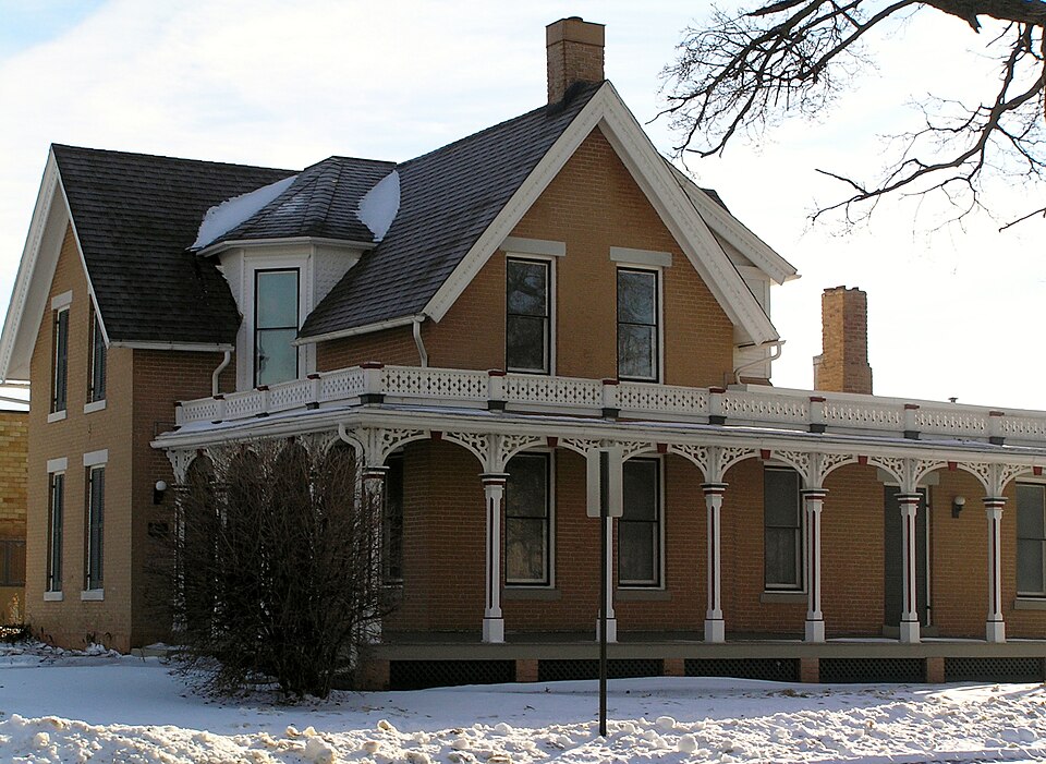
Photograph of Glick-Sower House
Photograph by Daniel Hartwig, CC BY 2.0. Via Wikimedia Commons.

Glick-Sower House

Listed on the National Register of Historic Places in 1993.

From the record

“The Glick-Sower House, also known as the Susie Sower House, is located in Marshalltown, Iowa. George Glick and has been listed on the National Register of Historic Places since 1993.”

Wikipedia article Glick-Sower House, CC BY-SA 4.0.

One of 18 National Register listings published here for Marshall County · listed in 1993 · category: Building.

Sources: the Wikipedia article · the case file at the National Archives · the National Register database, National Park Service

The listing

  • What is counted as historic. The nomination lists 1 building as contributing to the listing.
  • Listed as. Glick--Sower House - the National Register files a house under its owner's surname.
  • Address. 201 E. State St., Marshalltown, 50158
  • When was it listed? April 1993
  • Category. building
  • Township. Taylor township
  • Architectural style. Gothic Revival
  • National Register reference number. 93000331 - the number the National Park Service assigned this property when it was listed, and the key its nomination file is catalogued under at the National Archives.

Fires near this property

4 since 2010

Regional context, not property-specific evidence. The federal wildfire occurrence database lists 4 fires within 5 miles of Glick-Sower House between 2010 and 2012, burning about 14 acres in total. None started naturally. None was recorded as arson. Distance is straight-line from the map coordinates, so a fire counted here may appear on a neighbouring settlement's page as well.

Reported cause Fires
Missing data/not specified/undetermined3
Debris and open burning1

The most recent of them, most recent first, with the day each was reported and the service that recorded it.

DateCause SizeReported by Name on the report
30 March 2011Missing data/not specified/undetermined12 acresIowa Department of Natural ResourcesMM 9, MARSHALLTOWN, IA
26 March 2010Missing data/not specified/undeterminedunder an acreIowa Department of Natural Resources1959 VINE AVE, MARSHALLTOWN, IA, IOWA
28 October 2011Missing data/not specified/undetermined1.0 acresIowa Department of Natural Resources1981 WOODBURY ROAD AND COUNTY 9 ROAD, IA
10 October 2012Debris and open burningunder an acreIowa Department of Natural Resourcesnot named

Every fire recorded in Marshall County

Mines and quarries near this property

9 within 5 miles

Regional context, not property-specific evidence. The federal mineral resources record lists 9 workings within 5 miles of Glick-Sower House: 9 past producers. None of them still produces. What was taken out: Sand and Gravel, Construction, Stone, Crushed/Broken, Flagstone, Limestone, Dimension. Distance is straight-line from the map coordinates, so a quarry counted here may appear on a neighbouring settlement's page as well.

Where SiteCommodity StatusRecorded
Corrick QuarryLimestone, DimensionPast Producer
UnknownFlagstonePast Producer
Ash QuarryStone, Crushed/BrokenPast Producer
Rockton QuarryStone, Crushed/BrokenPast Producer
Timber Creek QuarryStone, Crushed/BrokenPast Producer
Ruth PitSand and Gravel, ConstructionPast Producer
Slappey PitSand and Gravel, ConstructionPast Producer
UnknownSand and Gravel, ConstructionPast Producer

Every working recorded in Marshall County

Storms near this property

60 of 146 shown

Regional context, not property-specific evidence. The National Weather Service names Marshalltown, the town this property stands in, in 146 storm reports between 1994 and 2025: 55 thunderstorm wind, 41 hail, 24 heavy rain, 14 flood. No death or injury is recorded in these reports. Each account below is quoted exactly as the forecast office filed it, from the NOAA Storm Events Database, and each date opens the federal record of that event.

WhenEvent Place namedHarm What the report says
July 2011Thunderstorm WindMarshalltown$500,000Extensive damage reported in Marshalltown. Trees over roads, trees on homes, gas leaks, and structural damage.
August 2015FloodMarshalltown$250,000The Iowa River at Marshalltown crested at 19.98 feet on 31 August 2015 at 8:30 PM CDT.
June 2014Thunderstorm WindMarshalltown$200,000A dugout at a school was destroyed by high winds. Power was out through much of the town.
June 2007Flash FloodMarshalltown$150,000no account filed
May 2019HailMarshalltown$100,000Trained spotter reported ping pong ball sized hail ongoing.
May 2017Thunderstorm WindMarshalltown$100,000Emergency manager reported tree on a large propane tank near Liscomb on Oaks Ave, many trees and power lines down in Marshalltown, traffic lights down in Marshalltown, and a barn down.
April 2007FloodMarshalltown$100,000no account filed
August 2004Thunderstorm WindMarshalltown$100,000no account filed
September 2000Thunderstorm WindMarshalltown$100,000no account filed
June 1998FloodMarshalltown$100,000no account filed
June 1998Thunderstorm WindMarshalltown$75,000no account filed
December 2015FloodMarshalltown$50,000The Iowa River crested at 20.43 feet on 15 December 2015 at 14:15 UTC.
July 2011Thunderstorm WindMarshalltown$50,000Measured winds on personal weather station. Damage included fences down, trees snapped, and siding ripped from houses.
June 2008Flash FloodMarshalltown$50,000Many city streets were under water from heavy rain.
March 2007FloodMarshalltown$50,000no account filed
August 2004Thunderstorm WindMarshalltown$50,000no account filed
July 2003HailMarshalltown$50,000no account filed
June 1998FloodMarshalltown$50,000no account filed
June 1998Thunderstorm WindMarshalltown$50,000no account filed
April 1994HailMarshalltown$50,000no account filed
March 2002Thunderstorm WindMarshalltown$30,000no account filed
June 1998FloodMarshalltown$30,000no account filed
August 2010Thunderstorm WindMarshalltown$25,000Power was knocked out by winds of 65 MPH.
June 2009Thunderstorm WindMarshalltown$25,000no account filed
May 2007FloodMarshalltown$25,000no account filed
June 2000Thunderstorm WindMarshalltown$25,000no account filed
July 2000HailMarshalltown$25,000no account filed
June 1997HailMarshalltown$25,000no account filed
June 2019Thunderstorm WindMarshalltown$20,000Public relayed images of tree and power pole damage. Time estimated from radar.
May 2017Thunderstorm WindMarshalltown$20,000Emergency manager reported roof damage to a farmstead and a barn blown down near the Marshalltown airport.
June 2008Thunderstorm WindMarshalltown$20,000no account filed
August 2004Thunderstorm WindMarshalltown$20,000no account filed
June 1998Thunderstorm WindMarshalltown$20,000no account filed
June 1998Tornado (F1)Marshalltown$20,000no account filed
July 2013Thunderstorm WindMarshalltown$15,000Many trees down in town, some 3 to 4 feet in diameter.
April 2009Flash FloodMarshalltown$15,000Water was reported as waist deep on Linn St and Church St in Marshalltown.
July 2001Thunderstorm WindMarshalltown$15,000no account filed
October 2011LightningMarshalltown$10,000Lightning struck a school building.
April 2009Flash FloodMarshalltown$10,000Water over Garwin Rd. near the intersection with Iowa Highway 14.
April 2009Flash FloodMarshalltown$10,000Water was over the northbound lanes of Iowa Highway 14.
August 2009Thunderstorm WindMarshalltown$10,000no account filed
July 2007Thunderstorm WindMarshalltown$10,000no account filed
September 2005Thunderstorm WindMarshalltown$10,000no account filed
August 2002Thunderstorm WindMarshalltown$10,000no account filed
July 2001Thunderstorm WindMarshalltown$10,000no account filed
July 2000HailMarshalltown$10,000no account filed
May 1999Thunderstorm WindMarshalltown$10,000no account filed
April 1996HailMarshalltown$10,000no account filed
July 1995Thunderstorm WindMarshalltown$10,000no account filed
June 1994Thunderstorm WindMarshalltown$5,000Thunderstorms formed during the middle to late afternoon hours over northwest Iowa. Overall dynamics were weak, however weak moisture advection during the day combined with temperatures warming to around 90 degrees contributed to making the airmass quite unstable. After taking into account the 90 degree temperature and the dew point around the 70 degree mark yielded a CAPE value of over 5000 J-Kg-1 by the late afternoon. The severe storms were confined to a rather narrow area. The first severe weather reported occurred over the far northwest Iowa, where three-quarter inch diameter hail fell at Sibley. The storms drifted southeast and produced hail in Clay County as well. Hail the size of quarters fell southwest of Spencer. Webster County was hard hit with both hail and heavy rainfall. Rain fell at the rate of two to three inches per hour in the Lizard Creek Basin. This caused some minor flooding. Street flooding also occurred in Fort Dodge. No serious flooding occurred however. It was generally urban flooding. Southern Webster County was pelted by hail. In the Harcourt area, dime-size hail accumulated to a depth of two inches. Northwest of Harcourt, golf ball-size hail was reported. Severe crop damage was reported to the corn crop in the area. The storms produced two small tornadoes, although there were several other unconfirmed reports around the central part of the state. One of the tornadoes touched down briefly in Hamilton County south of Webster City. The other was north of Boone, in Boone County. Neither of the tornadoes were on the ground very long and no significant damage was reported. High winds became a problem as the storms moved toward central Iowa. Winds of 60 mph were reported in the city of Boone. High winds took down several large trees in the city of Marshalltown. Most other reports during the afternoon and evening hours were of pea- to marble-size hail and 40 to 45 mph winds. During the evening, a second area of storms that had formed over eastern South Dakota and Minnesota moved into northwest Iowa. Most of them were not severe, though one did drop three-quarter inch diameter west of Le Mars before weakening.
May 2013Thunderstorm WindMarshalltown$5,000no account filed
March 2006HailMarshalltown$5,000no account filed
May 2003HailMarshalltown$5,000no account filed
June 2002HailMarshalltown$5,000no account filed
September 2001Thunderstorm WindMarshalltown$5,000no account filed
June 1998Thunderstorm WindMarshalltown$5,000no account filed
July 2022LightningMarshalltown$4,000Firefighters responded to a home struck by lightning, resulting in a fire in the attic.
July 2007Thunderstorm WindMarshalltown$3,000no account filed
March 2007Thunderstorm WindMarshalltown$3,000no account filed

Every storm recorded in Marshall County

Map coverage status

No historic map-sheet match is published for this property yet. That does not mean no map exists. This record needs a coordinate-quality review before it can be joined to a sheet boundary. Browse the county's mapped places while that work is pending.

Listed places nearby

6 within 8 miles

Other National Register properties close enough to walk or drive between, ordered by distance from this one. Both positions come from the same geocoding pass that matched these properties to their map sheets.

Photograph PropertyDistance Listed
Thaddeus Binford Houseunder 500 feet1984
Marshalltown Downtown Historic District0.2 miles2002
Marshall County Courthouse0.2 miles1972
C. H. Whitehead House0.7 miles1979
Leroy R. Willard House0.7 miles1976
Robert H. Sunday House1.9 miles1988

Sources for this property

National Archives recordThe nomination case file for reference 93000331 in Record Group 79.
Wikipedia articleCommunity-written account of this property, licensed CC BY-SA.
Marshall CountyAll 18 listed properties in this county.

Provenance

  • Listing record. National Park Service National Register of Historic Places, listed-properties dataset, current to 2026-05-22.
  • Map join. Address geocoded through the United States Census geocoder, then tested against the published boundary of every sheet in the USGS Historical Topographic Map Collection.
  • How this page is made. Listing fields come from federal records; map-sheet coverage is a labelled coordinate-to-boundary calculation, not a source-field claim.
  • Wildfire. Short, Karen C. 2022. Spatial wildfire occurrence data for the United States, 1992-2020 [FPA_FOD_20221014]. 6th Edition. Fort Collins, CO: Forest Service Research Data Archive. https://doi.org/10.2737/RDS-2013-0009.6 Collected with United States Government funding and usable without additional permissions or fees.
  • Mines and quarries. USGS Mineral Resources Data System (MRDS) https://mrdata.usgs.gov/mrds/ A work of the United States government, no copyright under 17 U.S.C. 105.
  • Storms. NOAA National Centers for Environmental Information, Storm Events Database https://www.ncei.noaa.gov/stormevents/ A work of the United States government, no copyright under 17 U.S.C. 105. Narratives are quoted verbatim from the National Weather Service report and are not edited or summarised.