
BlockBefore
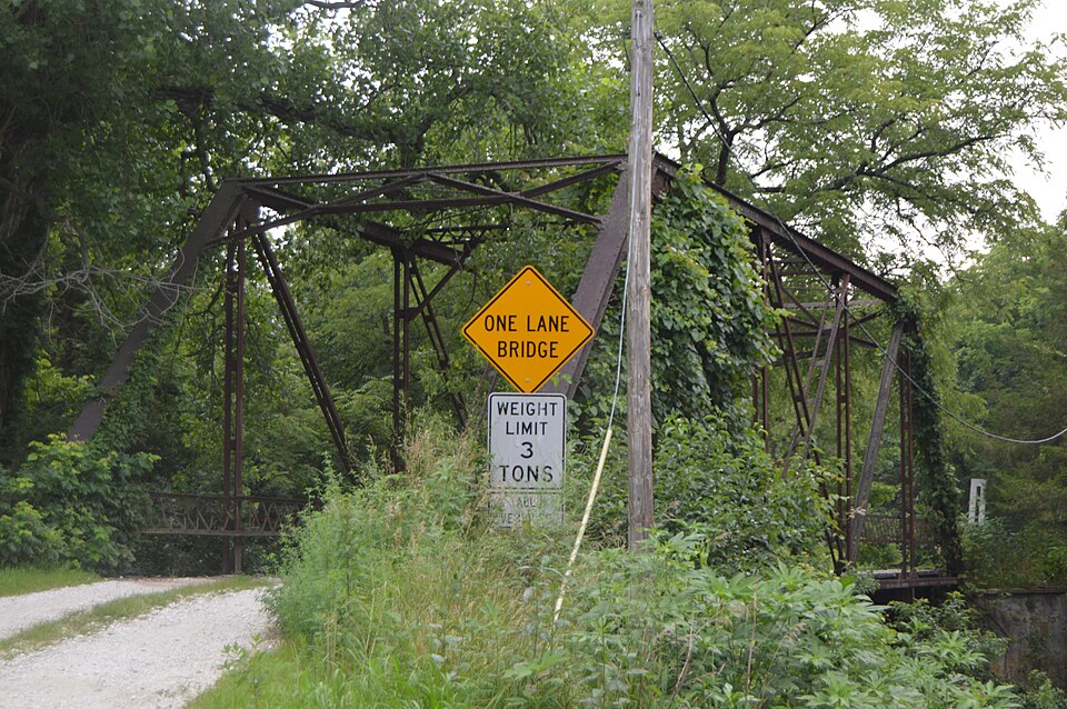
Photograph of Hawkeye Creek Bridge
Photograph by Nyttend, Public domain. Via Wikimedia Commons.

Hawkeye Creek Bridge

Built in 1909. Listed on the National Register of Historic Places in 1998.

From the record

“Hawkeye Creek Bridge is a historic structure located in a rural area northeast of Mediapolis, Iowa, United States. The Des Moines County Board of Supervisors contracted with Clinton Bridge and Iron Works on September 23, 1909, to design and build this bridge.”

Wikipedia article Hawkeye Creek Bridge, CC BY-SA 4.0.

One of 35 National Register listings published here for Des Moines County · listed in 1998 · category: Structure · built in 1909.

Sources: the Wikipedia article · the case file at the National Archives · the National Register database, National Park Service

The listing

  • What is counted as historic. The nomination lists 1 structure as contributing to the listing.
  • Address. Hawkeye Rd. over Hawkeye Cr., Mediapolis, 52646
  • When was it listed? June 1998
  • Category. structure
  • Also known as. Highway Bridges of Iowa MPS
  • Township. Huron township
  • When was it built? 1909
  • National Register reference number. 98000790 - the number the National Park Service assigned this property when it was listed, and the key its nomination file is catalogued under at the National Archives.

Fires near this property

7 since 2006

Regional context, not property-specific evidence. The federal wildfire occurrence database lists 7 fires within 5 miles of Hawkeye Creek Bridge between 2006 and 2016, burning about 76 acres in total. None started naturally. None was recorded as arson. Distance is straight-line from the map coordinates, so a fire counted here may appear on a neighbouring settlement's page as well.

Reported cause Fires
Missing data/not specified/undetermined3
Recreation and ceremony2
Equipment and vehicle use1
Debris and open burning1

The most recent of them, most recent first, with the day each was reported and the service that recorded it.

DateCause SizeReported by Name on the report
8 June 2016Recreation and ceremonyunder an acrePort Louisa National Wildlife RefugeHALL'S LK CAMPFIRE 2
8 June 2016Recreation and ceremonyunder an acrePort Louisa National Wildlife RefugeHALL'S LK CAMPFIRE1
25 April 2014Debris and open burning4.0 acresIowa Department of Natural Resourcesnot named
20 March 2014Equipment and vehicle use1.0 acresIowa Department of Natural Resourcesnot named
8 February 2006Missing data/not specified/undetermined1.0 acresIowa Department of Natural Resourcesnot named
21 November 2011Missing data/not specified/undeterminedunder an acreIowa Department of Natural ResourcesFIELD W AND S OF 17901 , IA
3 October 2006Missing data/not specified/undetermined70 acresIowa Department of Natural Resourcesnot named

Every fire recorded in Des Moines County

Mines and quarries near this property

5 within 5 miles

Regional context, not property-specific evidence. The federal mineral resources record lists 5 workings within 5 miles of Hawkeye Creek Bridge: 4 past producers, 1 producer. 1 still produces. What was taken out: Stone, Crushed/Broken, Sand and Gravel, Construction. Distance is straight-line from the map coordinates, so a quarry counted here may appear on a neighbouring settlement's page as well.

Where SiteCommodity StatusRecorded
Oakville PitSand and Gravel, ConstructionPast Producer
County QuarryStone, Crushed/BrokenPast Producer
Elrick Junction QuarryStone, Crushed/BrokenPast Producer
Nelson QuarryStone, Crushed/BrokenProducer
UnknownStone, Crushed/BrokenPast Producer

Every working recorded in Des Moines County

Storms near this property

31 since 1995

Regional context, not property-specific evidence. The National Weather Service names Mediapolis, the town this property stands in, in 31 storm reports between 1995 and 2024: 18 thunderstorm wind, 8 hail, 2 heavy rain, 1 lightning. No death or injury is recorded in these reports. Each account below is quoted exactly as the forecast office filed it, from the NOAA Storm Events Database, and each date opens the federal record of that event.

WhenEvent Place namedHarm What the report says
July 2003Heavy RainMediapolis$10,000Considerable street flooding. Fell in 30 minutes
July 1997LightningMediapolis$10,000Lightning was the cause of an attic fire in a family home. The children in the home, looking out the window, reported seeing a "fireball" next door. The parents heard a terrible crash, then discovered the fire. The fire was put out quickly by the homeowner. Besides some fire and water damage in the attic, one wall outlet, a cordless phone, and an air conditioner were damaged.
August 1995Thunderstorm WindMediapolis$10,000no account filed
October 2004Thunderstorm WindMediapolis$1,0008 inch diameter solid pine tree downed.
June 2007Thunderstorm WindMediapolis$500Trees were downed and roof shingles were ripped off.
June 2007Thunderstorm WindMediapolis$500A tree branch 8 inches in diameter was blown down covering part of the road between Orchard and Harrison streets.
June 2024Thunderstorm WindMediapolis-Estimated wind speed, with lawn furniture being thrown around.
March 2023Tornado (EF2)Mediapolis-A brief tornado tracked east across the southern portions of the town of Mediapolis, destroying siding and shingles on a few homes and businesses. Numerous large tree limbs fell on mobile homes and frame houses, damaging roofs and siding. In the middle of town, at it's peak strength, the tornado widened to 150 yards and produced EF2 damage at a home, where it removed the entire roof, and snapped a few large trees off just above the ground. The tornado dissipated quickly on the east side of town. The peak winds are estimated to be 120 mph with this tornado.
August 2020Thunderstorm WindMediapolis-Numerous tree branches were blown down all over town.
November 2020Thunderstorm WindMediapolis-The EM passed along a public report of an uprooted tree in the Mediapolis/Kossuth area along with several downed tree limbs in the area. The time of the event was estimated using radar.
July 2020Thunderstorm WindMediapolis-Trees were uprooted along with large limbs blown down. Tree limbs fell onto a roof of a house.
July 2020Thunderstorm WindMediapolis-Significant tree and limb damage throughout the town of Mediapolis. Power is out.
August 2019Thunderstorm WindMediapolis-Several reports of large trees damaged with branches down and a leaning power pole.
August 2017Thunderstorm WindMediapolis-A member of the public reported 2 large tree branches down. The time of the event was estimated using radar.
June 2017Thunderstorm WindMediapolis-A spotter estimated winds of 60 mph.
June 2017Thunderstorm WindMediapolis-A residential swing set was damaged.
June 2015Thunderstorm WindMediapolis-Twelve inch diameter trees were blown down on north side of town, power was also reported out.
May 2014HailMediapolis-Golf ball sized hail fell 1 mile north of Mediapolis, IA at 531 pm CDT May 11.
June 2012HailMediapolis-Quarter sized hail fell in Mediapolis, IA at 816 pm CDT June 29.
September 2012Thunderstorm WindMediapolis-Wind gusts estimated to be 65 mph blew a large tree limb down in Mediapolis, IA around 450 am CDT September 5.
March 2011Thunderstorm WindMediapolis-A trained spotter near Mediapolis estimated a wind gust of 60 mph.
June 2010Thunderstorm WindMediapolis-Wind gusts measured to be 63 mph were observed in Mediapolis, IA at 508 pm CDT June 23. South of town winds were even stronger, unroofing a barn and throwing the roof through a nearby garage. A grain bin just southeast of town was damaged.
June 2009Thunderstorm WindMediapolis-Wind gusts were estimated to be 60 mph in Mediapolis, IA around 520 pm June 19.
September 2008Flash FloodMediapolis-Heavy rains caused flash flooding of a few parts of Des Moines County during the morning of September 13.||In Burlington, a 60 foot tall tree fell over in Crapo Park due to the ground being so saturated with flood waters. Also, about 20 loose railroad ties were carried down the 700 block of Jefferson Street by flood waters about 2 feet deep forcing its closure for a time.||A water rescue was performed on two motorists who drove a Jeep into flood waters near Flint Creek in Burlington and West Burlington.||North of Mediapolis, portions of Highway 61 were under water.
March 2006HailMediapolis-just east of the city; also estimated 50 mph winds
October 2004Heavy RainMediapolis-1.1 inches in 35 minutes.
May 2023HailMediapolis-no account filed
April 2015HailMediapolis-no account filed
May 2014HailMediapolis-no account filed
May 2007HailMediapolis-no account filed
April 1996HailMediapolis-no account filed

Every storm recorded in Des Moines County

Map coverage status

No historic map-sheet match is published for this property yet. That does not mean no map exists. This record needs a coordinate-quality review before it can be joined to a sheet boundary. Browse the county's mapped places while that work is pending.

Sources for this property

National Archives recordThe nomination case file for reference 98000790 in Record Group 79.
Wikipedia articleCommunity-written account of this property, licensed CC BY-SA.
Des Moines CountyAll 35 listed properties in this county.

Provenance

  • Listing record. National Park Service National Register of Historic Places, listed-properties dataset, current to 2026-05-22.
  • Map join. Address geocoded through the United States Census geocoder, then tested against the published boundary of every sheet in the USGS Historical Topographic Map Collection.
  • How this page is made. Listing fields come from federal records; map-sheet coverage is a labelled coordinate-to-boundary calculation, not a source-field claim.
  • Wildfire. Short, Karen C. 2022. Spatial wildfire occurrence data for the United States, 1992-2020 [FPA_FOD_20221014]. 6th Edition. Fort Collins, CO: Forest Service Research Data Archive. https://doi.org/10.2737/RDS-2013-0009.6 Collected with United States Government funding and usable without additional permissions or fees.
  • Mines and quarries. USGS Mineral Resources Data System (MRDS) https://mrdata.usgs.gov/mrds/ A work of the United States government, no copyright under 17 U.S.C. 105.
  • Storms. NOAA National Centers for Environmental Information, Storm Events Database https://www.ncei.noaa.gov/stormevents/ A work of the United States government, no copyright under 17 U.S.C. 105. Narratives are quoted verbatim from the National Weather Service report and are not edited or summarised.