 Block
From the record
7 National Register listings published here, 1 of them a National Historic Landmark.
Sources: the National Register database, National Park Service
67 topographic sheets cover 36 settlements here, and 7 properties are on the National Register of Historic Places.
7 National Register listings published here, 1 of them a National Historic Landmark.
Sources: the National Register database, National Park Service
Every property in this county listed on the National Register of Historic Places, with the year it was listed and the federal nomination document.
| Photograph | Property | Type | Listed | Reference |
|---|---|---|---|---|
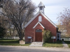 | Albion Methodist Church | building | 1986 | 86002161 |
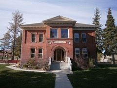 | Albion Normal School Campus | district | 1980 | 80001298 |
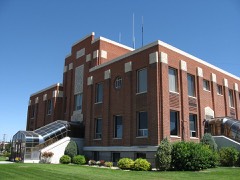 | Cassia County Courthouse | building | 1987 | 87001583 |
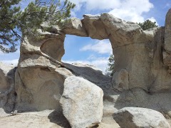 | City of Rocks | district | 1966 | 66000308 |
| Granite Pass | site | 1972 | 72000439 | |
| Oakley Historic District | district | 1980 | 80001299 | |
| Swanger Hall | building | 1978 | 78001058 |
Every wildfire the federal occurrence database records inside this county: 920 of them, burning about 511,214 acres. 512 started naturally and 33 were recorded as arson. Each settlement page carries the fires within five miles of it.
| Reported cause | Fires |
|---|---|
| Natural | 512 |
| Equipment and vehicle use | 109 |
| Missing data/not specified/undetermined | 87 |
| Recreation and ceremony | 77 |
| Debris and open burning | 36 |
| Power generation/transmission/distribution | 34 |
| Arson/incendiarism | 33 |
| Fireworks | 10 |
| Smoking | 6 |
| Other causes | 5 |
| Firearms and explosives use | 4 |
| Railroad operations and maintenance | 4 |
| Misuse of fire by a minor | 3 |
The five largest, by the area the report gives. None of them was recorded as arson.
| Date | Cause | Size | Reported by | Name on the report |
|---|---|---|---|---|
| 12 September 2020 | Missing data/not specified/undetermined | 90,143 acres | Sawtooth National Forest | BADGER |
| 5 August 2012 | Natural | 88,909 acres | Sawtooth National Forest | CAVE CANYON |
| 6 July 2007 | Natural | 72,361 acres | Sawtooth National Forest | BLACK PINE 2 |
| 22 September 2018 | Debris and open burning | 13,618 acres | Idaho Falls District | CONNER |
| 1 August 1996 | Natural | 12,986 acres | Twin Falls District | LAKEWALCOT |
| 26 August 1996 | Debris and open burning | 11,320 acres | Twin Falls District | ELBA |
| 27 July 2000 | Natural | 10,944 acres | Sawtooth National Forest | MONUMENT CANYON |
| 18 August 2000 | Natural | 10,587 acres | Twin Falls District | C ROCKS |
Every settlement page carries the fires within five miles of it - see the settlement index below.
The NOAA Storm Events Database holds 243 reports for this county, causing 4 deaths, 12 injuries and about $6,052,000 in recorded property damage. Each settlement page carries the reports that name it.
| Kind of event | Reports |
|---|---|
| Thunderstorm Wind | 126 |
| Hail | 59 |
| Flash Flood | 22 |
| Tornado | 10 |
| Funnel Cloud | 9 |
| Heavy Rain | 8 |
| Lightning | 4 |
| Flood | 3 |
| Wildfire | 2 |
The most serious of them, by death, then injury, then recorded damage. The accounts are quoted exactly as the forecast office filed them.
| When | Event | Place named | Harm | What the report says |
|---|---|---|---|---|
| August 1988 | Thunderstorm Wind | not stated | 2 killed, 10 hurt | no account filed |
| July 1996 | Lightning | Burley | 1 killed, 1 hurt | no account filed |
| July 1996 | Flash Flood | Malta | 1 killed, 1 hurt | no account filed |
| February 2017 | Flood | Burley | $5,240,000 | A warmup in temperatures caused extensive snow melt to lower elevations of Cassia County with devastating flooding throughout the rural county. Flooding began in earnest on the 5th. Interstate 86 was closed for a 36 mile stretch in the county with flooding over the Raft River bridges. A foot and a half of water was over the interstate and it was closed from the 6th until the 9th. The interstate began to flood on the 5th. Cassia County was declared a state disaster area. Dozens of homes were severely damaged by flood waters. Many private wells and septic systems flooded contaminating many homes. Several back roads had to be closed and many suffered tremendous damage. |
| June 2005 | Thunderstorm Wind | Countywide | $200,000 | A strong thunderstorm brought wind damage to much of Cassia County. Several trees were downed with at least 7 vehicles damaged by falling trees in Oakley. Sate highway 77 in Albion was blocked by a downed tree for more than an hour. In Declo, a tree crashed through the roof of a house on Main Street. Several power outages also were reported. |
| March 2017 | Flood | Burley | $175,000 | Sheet flooding continued in March throughout Cassia although effects were not nearly as strong as February. Property and road damage continued to add up and many fields in the Oakley area remained under water for much of the month. |
| May 2005 | Flash Flood | Central Portion | $110,000 | 1 to 2 inches of rainfall in a 2 hour period created extensive flash flooding in the towns of Albion and Oakley. In Albion, Marsh and Land Creeks flooded with the city of Albion declared a disaster area. 3 county road bridges/culverts were washed out. This cut off access to 6 homes. A foot of water was flowing across state highway 77 with damage to other county roads. 8 to 11 homes in Albion reported extensive basement and/or bedroom and kitchen flooding. Birch Creek created flooding in Oakley. Water from the Birch Creek Diversion canal flooded numerous roads but caused no damage. 1 home had basement flooding. |
| July 2001 | Thunderstorm Wind | Malta | $70,000 | A severe thunderstorms with measured gusts to 69 mph affected the city of Malta in Cassia County. Most of the damage occurred just northeast of the city along Sublett Road. Several small trees were downed, an attached garage was destroyed, approximately 20 power poles were downed, some trees blown across Sublett road, several residential windows and car windows blown out. the strong winds hit between 4 pm and 5 pm MDT. Damage to the electric company alone measured 40,000 dollars. |
| May 1993 | Thunderstorm Wind | not stated | $50,000 | A roof was torn off the laundry room of the Creekside Inn in Burley. A fence surrounding the Inn's swimming pool was also damaged, and power to the establishment was knocked out. Winds at the Burley airport were gusting to 59 mph(51 knots). The storm also blew down some power poles, according to the Cassia County Sheriff's Department. |
| March 2006 | Thunderstorm Wind | Oakley | $43,000 | no account filed |
| October 2019 | Thunderstorm Wind | View | $40,000 | A very large tree over 3 feet in diameter was uprooted and crashed into a residence on E 400 S just west of S 350 E. Roof and the back half of residence were destroyed. A second large tree next to the residence also uprooted. Large trees were snapped off approximately half way up along E 400 S near S 250 E. 2 other large trees 2-3 feet in diameter uprooted half way in between S 350 E and S 250 E and power pole was snapped in half. |
| December 2025 | Thunderstorm Wind | Idahome | $36,000 | Interstate 84 eastbound closed between interstate 86 eastbound and mile post 245 due to multiple commercial vehicle rollovers due to thunderstorm winds. |
| May 2009 | Thunderstorm Wind | Burley | $30,000 | Several trees were downed in Burley by a microburst wind with several trees on houses and extensive shingle damage reported. Light fixtures were shattered on several homes. |
| March 2011 | Thunderstorm Wind | Burley | $10,000 | Extensive damage and warning level winds occurred with the passage of a cold front the evening of March 10th. Two trees were downed into a house in Burley. Several trees down at Burley parks and golf course. |
| May 2005 | Lightning | Burley | $10,000 | Lightning in Burley struck an electrical light system at Overland and 14th Street causing damage. |
| May 2005 | Flash Flood | Albion | $6,500 | Marsh Creek in Albion flooded. A culvert was washed and one home was flooded. |
| September 2013 | Flash Flood | Oakley | $6,000 | Flash flooding occurred in the south foothills of Oakley. Heavy rain over a burn area caused water, debris and mud to flood one basement and several outlying buildings and potato cellars near the Mountain Meadows Ranch. The flow over burn areas brought ash into the debris and a foot of water and silt entered many ranch buildings and one basement. |
| September 2013 | Flash Flood | Oakley | $4,000 | Radar indicated about 2 to 3 inches of rainfall in southern Cassia County near Utah border. Birch Creek and Goose Creek roads flooded in the Oakley area and Lynn Road in Almo flooded and washed out. The roads were strewn with debris, branches and trees. |
| July 2012 | Thunderstorm Wind | Burley Arpt | $4,000 | Seventy-eight mile per hour wind gust recorded at Burley airport with power outages in Cassia County and trees downed. |
| June 1998 | Tornado (F0) | Burley | $4,000 | Evergreen Nursery greenhouse roofs removed and plants damaged. |
| July 2004 | Flash Flood | Oakley | $3,000 | no account filed |
| May 2014 | Thunderstorm Wind | Declo | $2,000 | A strong thunderstorm caused a gas station to be blown over in the city of Declo. |
| July 2013 | Thunderstorm Wind | Burley | $2,000 | An 8 foot by 10 foot shed blown down by thunderstorm winds in Burley. |
| September 2007 | Thunderstorm Wind | Burley | $2,000 | Thunderstorm winds damaged the roof of an industrial building at the corner of Albion Avenue and 13th Street in Burley. |
| August 2015 | Lightning | Declo | $1,500 | Lightning started a fire in a grain field in Declo with 30 foot flames. 40 to 50 acres of a 140 acre field were destroyed by the fire. |
| May 2024 | Thunderstorm Wind | Burley | $1,000 | Reports of tree damage, power outages with Idaho Power reporting 1,100 customers without power in Burley. |
| August 2021 | Thunderstorm Wind | Burley | $1,000 | Multiple power outages affecting over 500 customers near Milner, Hobson, and Hynes. |
| August 2003 | Thunderstorm Wind | Oakley | $1,000 | no account filed |
| April 2026 | Thunderstorm Wind | Idahome | - | The Yale ITD mesonet site recorded a 60 mph thunderstorm outflow wind gust. |
| May 2025 | Thunderstorm Wind | Marion | - | A 62 mph wind gust was recorded at the Cotton Ridge mesonet site. |
| May 2025 | Thunderstorm Wind | Albion | - | A 59 mph wind gust recorded at Connor Summit on Idaho 77. |
| May 2025 | Thunderstorm Wind | Almo | - | A 60 mph wind gust measured near Almo near intersection of Idaho 77 and Narrows Rd. |
| July 2025 | Thunderstorm Wind | Oakley | - | A 59 mph thunderstorm outflow wind measured at the Cotton Ridge RAWS site. |
| July 2025 | Thunderstorm Wind | Strevell | - | Mesonet station Pilot Gold recorded a 61 mph thunderstorm outflow wind. |
| July 2025 | Thunderstorm Wind | Strevell | - | The Moburg Canyon mesonet site recorded a 73 mph thunderstorm outflow wind gust. |
| July 2025 | Thunderstorm Wind | Strevell | - | A 58 mph thunderstorm outflow wind gust was measured at the Pilot Gold mesonet site. |
| December 2025 | Thunderstorm Wind | Churchill | - | A 70 mph wind gust measured at intersection of W 700 S and 300 W. |
| December 2025 | Thunderstorm Wind | Albion | - | A 58 mph wind gust measured off of 950 S. |
| May 2024 | Thunderstorm Wind | Churchill | - | A private weather station near Churchill measured a 58 mph wind gust. |
| May 2024 | Thunderstorm Wind | Idahome | - | A 70 mph wind gust measured at the Idahome ITD mesonet site. |
| May 2024 | Thunderstorm Wind | Burley Arpt | - | A 62 mph wind gust recorded at the Burley Municipal Airport ASOS. |
| May 2024 | Thunderstorm Wind | Idahome | - | The ITD Idahome site recorded a 65 mph wind gust. |
| May 2024 | Thunderstorm Wind | Idahome | - | A 67 mph wind gust measured at the MALI mesonet site. |
| May 2024 | Thunderstorm Wind | Burley | - | A 59 mph wind gust measured 4 miles south of Burley at station DVI01498. |
| May 2024 | Thunderstorm Wind | Declo | - | A 65 mph wind gust measured at the Yale ITD mesonet site. |
| May 2024 | Thunderstorm Wind | Oakley | - | Idaho Power reported 100 customers without power due to thunderstorm winds south of Oakley. |
| July 2024 | Thunderstorm Wind | Marion | - | A 77 mph thunderstorm outflow wind measured at the Cotton Ridge mesonet site. |
| June 2024 | Thunderstorm Wind | Bridge | - | A 66 mph wind gust measured at Moburg Canyon. |
| September 2024 | Thunderstorm Wind | Marion | - | A 65 mph thunderstorm outflow wind measured at Cotton Ridge. |
| September 2024 | Thunderstorm Wind | Bridge | - | Pilot Gold mesonet station recorded a 69 mph wind gust. |
| September 2024 | Thunderstorm Wind | Bridge | - | A 61 mph wind gust measured at Moburg Canyon. |
| September 2024 | Thunderstorm Wind | Idahome | - | A 59 mph wind gust measured at Idahome. |
| September 2024 | Thunderstorm Wind | Idahome | - | The Yale ITD site on interstate 84 measured a 64 mph thunderstorm outflow wind. |
| August 2024 | Thunderstorm Wind | Marion | - | A 64 mph wind gust measured at Cotton Ridge. |
| August 2024 | Thunderstorm Wind | Marion | - | A 64 mph wind gust measured at Cotton Ridge. |
| May 2023 | Flash Flood | Churchill | - | Water flowing over Highway 30 with road and bridge crews called to site. |
| May 2023 | Flash Flood | Burley | - | Extensive street flooding reported in Burley. |
| June 2023 | Thunderstorm Wind | Elba | - | A 59 mph wind gust measured in Elba. |
| August 2023 | Hail | Churchill | - | One inch hail measured west of Churchill in Cassia County. |
| August 2023 | Thunderstorm Wind | Strevell | - | A 62 mph wind gust measured at Moburg Canyon. |
The Survey's mineral resources record lists 243 workings inside this county. 19 still produce and 224 are closed or unrecorded. Each settlement page carries the workings within five miles of it.
| Commodity | Workings |
|---|---|
| Sand and Gravel, Construction | 88 |
| Geothermal | 40 |
| Gold | 19 |
| Lead | 18 |
| Uranium | 9 |
| Copper | 9 |
| REE | 9 |
| Pumice | 8 |
| Clay | 6 |
| Marble, Dimension | 5 |
| Lignite | 5 |
| Silver | 4 |
| Titanium, Iron, Garnet, Zirconium | 4 |
| Zinc | 3 |
The least common of them first, because a county's hundredth gravel pit says nothing its first ten did not.
| Where | Site | Commodity | Status | Recorded |
|---|---|---|---|---|
| Albion Group Mine | Lead, Silver, Gold, Copper, Zinc | Past Producer | Chalcopyrite, Galena, Malachite, Pyromorphite, Sphalerite, Tetrahedrite | |
| Almo Basin-Circle Creek #3 | REE, Titanium, Garnet, Iron | Unknown | ||
| Almo Basin-Edwards Creek | REE, Zirconium, Titanium, Garnet, Iron | Unknown | ||
| Almo Basin-Raft River #1 | REE, Garnet, Zirconium, Titanium, Iron | Unknown | ||
| Almo Basin-Raft River #3 | Garnet, Iron, Zirconium, Titanium, REE | Unknown | ||
| Big Bertha Group | Gold, Lead, Silver, Copper, Zinc | Past Producer | Vein | |
| Black Jack Scheelite | Tungsten | Occurrence | ||
| Boulder Creek Prospect | Copper, Silver, Lead | Occurrence | Galena, Malachite, Tetrahedrite | |
| Brooks Prospect | Beryllium, Thorium, Uranium | Occurrence | ||
| Burley Clay Mine | Brick Clay | Producer | Unconsolidated Sediments | |
| City of Rocks Mine | Feldspar, Uranium, Beryllium, Thorium | Past Producer | Pegmatite | |
| City of Rocks Uranium Deposit | Uranium, REE, Thorium | Occurrence | Magnetite | |
| Excelsior | Silver, Gold, Lead, Copper, Zinc | Producer | Vein | |
| Giant Lode | Gold, Silver, Lead, Zinc | Unknown | ||
| Harris and Hume Prospect | Silver, Gold, Lead | Past Producer | Vein | |
| Hazel Pine Mine | Silver, Lead, Gold, Zinc | Past Producer | Calamine, Smithsonite | |
| Idaho Quartzite | Silica | Prospect | ||
| Idaho Queen #1 | Beryllium, Uranium, Thorium | Occurrence | ||
| Melcher Mine | Lead, Silver, Copper, Gold | Past Producer | Vein | |
| Miller Cinnabar | Mercury, Copper, Lead, Arsenic, Barium-Barite | Past Producer | Cinnabar, Jamesonite, Tetrahedrite | |
| Mineral Gulch Prospect | Gold, Silver, Zinc, Copper | Occurrence | Copper, Gold, Tetrahedrite | |
| North Carson Creek | Limestone, General | Past Producer | ||
| Old Dominion Mine | Silver, Lead, Copper | Past Producer | 1888 | |
| Old Dominion Mine | Lead, Zinc, Silver, Copper | Past Producer | ||
| Ruth Mine | Zinc, Mercury, Silver, Copper | Past Producer | Cinnabar, Malachite, Smithsonite, Sphalerite, Tetrahedrite | |
| Silver Hills Mine | Lead, Zinc, Silver, Antimony, Copper, Gold | Past Producer | 1880, 1894 | |
| South Mountain Pegmatites | Feldspar | Occurrence | Pegmatite | |
| Tolman Mine | Gold, Arsenic, Mercury | Prospect | ||
| Unnamed Location | Gemstone | Occurrence | ||
| Unnamed Location | Uranium, Thorium, Beryllium | Occurrence | ||
| Unnamed Location | Copper, Mercury, Antimony, Zinc | Occurrence | ||
| White Mica Mining and Milling | Zinc, Silver, Lead, Gold, Copper | Occurrence | ||
| White Mica Mining and Milling | Gold, Copper, Lead, Silver, Zinc | Occurrence | ||
| Almo Basin-Circle Creek #1 | REE, Titanium, Iron, Garnet | Unknown | ||
| Almo Basin-Graham Creek | REE, Titanium, Iron, Garnet | Unknown | ||
| Connor Prospect | Lead, Silver, Gold | Occurrence | ||
| Crushed Rock Pit--Burley Hwy Dist | Stone, Crushed/Broken | Producer | ||
| East Dry Fork Prospect | Iron | Occurrence | Limonite | |
| Golden Eagle Mine | Lead, Gold, Silver, Copper | Past Producer | Vein | |
| Limestone Occurrence | Stone, Crushed/Broken, Clay | Occurrence | ||
| Mineral Gulch Prospect | Iron | Occurrence | ||
| Oakley Valley Stone,Inc | Stone | Producer | ||
| Rocky Mtn. Quarry | Stone | Producer | ||
| Valentine Mine | Mercury, Gold, Silver, Lead | Past Producer | Cinnabar | |
| Bill Anderson Kyanite Property | Kyanite | Occurrence | ||
| Cyanite Occurrence | Kyanite | Occurrence | Metamorphic | |
| Mineral Gulch Prospect | Copper, Zinc | Occurrence | Vein | |
| Phosphate Deposit | Phosphorus-Phosphates | Occurrence | ||
| Phosphate Deposit | Phosphorus-Phosphates | Occurrence | ||
| Posey No 5 | Kyanite | Occurrence | ||
| Quarry | Stone, Dimension | Unknown | ||
| Quarry | Stone, Dimension | Unknown | ||
| Rocky Mnt Quartzite Quarry | Stone, Dimension | Producer | ||
| Unnamed Location | Phosphorus-Phosphates | Occurrence | ||
| Almo Basin | REE, Titanium, Iron, Garnet, Zirconium | Unknown | ||
| Almo Basin-Circle Creek #2 | REE, Titanium, Iron, Garnet, Zirconium | Unknown | ||
| Almo Basin-Raft River #2 | REE, Titanium, Iron, Garnet, Zirconium | Unknown | ||
| Black Pine Mine | Gold, Silver | Past Producer | 1992 | |
| Kinney Mine | Lead, Silver | Past Producer | ||
| Trapper Creek #2 | REE, Titanium, Iron, Garnet, Zirconium | Unknown | ||
| Unnamed Location | Lead, Silver | Prospect | ||
| Barrett Prospect | Lignite, Uranium | Occurrence | ||
| Grant Prospect | Lignite, Uranium | Occurrence | ||
| Marble Quarry | Marble, Dimension | Past Producer | Metamorphic | |
| Marble Quarry | Marble, Dimension, Lead | Past Producer | Metamorphic | |
| Marble Quarry | Marble, Dimension | Past Producer | Metamorphic | |
| Marble Quarry | Marble, Dimension | Past Producer | Metamorphic | |
| Quarries | Marble, Dimension | Unknown | ||
| Unnamed Location | Lignite, Uranium | Occurrence | ||
| Unnamed Location | Lignite, Uranium | Past Producer | ||
| Worthington Prospect | Lignite, Uranium | Past Producer | ||
| Brick and Tile Clay Deposit | Clay | Unknown | ||
| Brick and Tile Clay Deposit | Clay | Prospect | ||
| Clay Deposit | Clay | Occurrence | Clay | |
| Clay Deposit | Clay | Occurrence | ||
| Gravel Pit | Clay | Unknown | ||
| Pumicite Deposit | Pumice | Occurrence | ||
| Pumicite Deposit | Pumice | Occurrence | ||
| Pumicite Deposit | Pumice | Occurrence | ||
| Pumicite Deposit | Pumice | Occurrence | ||
| Pumicite Occurrence | Pumice | Occurrence | ||
| Pumicite Occurrence | Pumice | Occurrence | ||
| Pumicite Occurrence | Pumice | Occurrence | ||
| Pumicite Pit | Pumice | Occurrence | ||
| City of Rocks Area | Uranium | Past Producer | ||
| City of Rocks Uranium Placer Deposit | Uranium | Prospect | Placer | |
| Gray Copper Prospect | Copper | Prospect | Malachite, Tetrahedrite | |
| Last Chance Group Prospect | Copper | Prospect | Vein | |
| Unnamed Location | Copper | Occurrence | ||
| Unnamed Location | Copper | Prospect | ||
| Uranium Deposit | Uranium | Occurrence | 1945 | |
| War Eagle Peak Prospect | Copper | Occurrence | Malachite, Tetrahedrite | |
| Myers Mine | Lead | Past Producer | ||
| Unnamed Location | Lead | Occurrence | ||
| Unnamed Location | Lead | Occurrence | ||
| Unnamed Location | Lead | Occurrence | ||
| Unnamed Location | Lead | Occurrence | ||
| Unnamed Location | Lead | Occurrence | ||
| Unnamed Location | Lead | Occurrence | ||
| Unnamed Location | Lead | Occurrence | ||
| Unnamed Location | Lead | Occurrence | ||
| Unnamed Location | Lead | Prospect | ||
| Bancroft Claim Placer | Gold | Past Producer | Placer | |
| Durango Placer | Gold | Past Producer | Placer | |
| G. W. Lish Farm Placer | Gold | Past Producer | Placer | |
| General Grant Placer | Gold | Past Producer | Placer | |
| Goose Creek Placer Deposits | Gold | Past Producer | ||
| Idaho Placer | Gold | Past Producer | Placer | |
| Marsh Creek Placer Deposits | Gold | Past Producer | ||
| Middle Mountain | Gold | Prospect | ||
| Raft River Placer Deposit | Gold | Past Producer | ||
| Snake River Placer | Gold | Past Producer | Placer | |
| Snake River Placers | Gold | Past Producer | Placer | |
| Spring Bar Placer | Gold | Past Producer | Placer | |
| Sweetzer Farm Placer | Gold | Past Producer | Placer | |
| Artesian City | Geothermal | Prospect | ||
| Bridger Hot Spring | Geothermal | Occurrence | ||
| Durfee Spring | Geothermal | Occurrence | ||
| Flowing Well | Geothermal | Unknown | ||
| Geothermal Location | Geothermal | Occurrence | ||
| Geothermal Location | Geothermal | Occurrence | ||
| Geothermal Location | Geothermal | Occurrence | ||
| Geothermal Location | Geothermal | Occurrence | ||
| Geothermal Location | Geothermal | Occurrence | ||
| Geothermal Location | Geothermal | Occurrence | ||
| Geothermal Location | Geothermal | Occurrence | ||
| Geothermal Location | Geothermal | Occurrence | ||
| Geothermal Location | Geothermal | Occurrence | ||
| Geothermal Location | Geothermal | Occurrence | ||
| Geothermal Location | Geothermal | Occurrence | ||
| Geothermal Location | Geothermal | Occurrence | ||
| Geothermal Location | Geothermal | Occurrence | ||
| Geothermal Location | Geothermal | Occurrence | ||
| Geothermal Location | Geothermal | Occurrence | ||
| Geothermal Location | Geothermal | Occurrence | ||
| Geothermal Location | Geothermal | Occurrence | ||
| Geothermal Location | Geothermal | Occurrence | ||
| Geothermal Location | Geothermal | Occurrence | ||
| Geothermal Location | Geothermal | Occurrence | ||
| Geothermal Location | Geothermal | Occurrence | ||
| Geothermal Location | Geothermal | Occurrence | ||
| Geothermal Location | Geothermal | Occurrence | ||
| Geothermal Location | Geothermal | Occurrence | ||
| Geothermal Location | Geothermal | Occurrence | ||
| Geothermal Location | Geothermal | Occurrence | ||
| Geothermal Location | Geothermal | Occurrence | ||
| Hot Well | Geothermal | Occurrence | ||
| Land Ranch Spring | Geothermal | Occurrence | ||
| Nelson Well | Geothermal | Prospect | ||
| Oakley Warm Springs | Geothermal | Occurrence | ||
| Oakley Warm Springs | Geothermal | Occurrence | ||
| Poulton Warm Spring | Geothermal | Occurrence | ||
| Sears Spring | Geothermal | Occurrence | ||
| Thoroughbred Spring | Geothermal | Occurrence | ||
| Trapper Creek # 1 | Geothermal | Prospect | ||
| Borrow Pit | Sand and Gravel, Construction | Past Producer | ||
| Borrow Pit | Sand and Gravel, Construction | Past Producer | ||
| Gordon Paving | Sand and Gravel, Construction | Past Producer | ||
| Gravel Pit | Sand and Gravel, Construction | Unknown | ||
| Gravel Pit | Sand and Gravel, Construction | Past Producer | ||
| Gravel Pit | Sand and Gravel, Construction | Unknown | ||
| Gravel Pit | Sand and Gravel, Construction | Unknown | ||
| Gravel Pit | Sand and Gravel, Construction | Past Producer | ||
| Gravel Pit | Sand and Gravel, Construction | Unknown | ||
| Gravel Pit | Sand and Gravel, Construction | Unknown | ||
| Gravel Pit | Sand and Gravel, Construction | Unknown | ||
| Gravel Pit | Sand and Gravel, Construction | Unknown | ||
| Gravel Pit | Sand and Gravel, Construction | Unknown | ||
| Gravel Pit | Sand and Gravel, Construction | Unknown | ||
| Gravel Pit | Sand and Gravel, Construction | Unknown | ||
| Gravel Pit | Sand and Gravel, Construction | Unknown | ||
| Gravel Pit | Sand and Gravel, Construction | Unknown | ||
| Gravel Pit | Sand and Gravel, Construction | Unknown | ||
| Gravel Pit | Sand and Gravel, Construction | Unknown | ||
| Gravel Pit | Sand and Gravel, Construction | Unknown | ||
| Gravel Pit | Sand and Gravel, Construction | Unknown | ||
| Gravel Pit | Sand and Gravel, Construction | Past Producer | ||
| Gravel Pit | Sand and Gravel, Construction | Unknown | ||
| Gravel Pit | Sand and Gravel, Construction | Unknown | ||
| Gravel Pit | Sand and Gravel, Construction | Past Producer | ||
| Gravel Pit | Sand and Gravel, Construction | Unknown | ||
| Gravel Pit | Sand and Gravel, Construction | Unknown | ||
| Gravel Pit | Sand and Gravel, Construction | Unknown | ||
| Gravel Pit | Sand and Gravel, Construction | Unknown | ||
| Gravel Pit | Sand and Gravel, Construction | Unknown | ||
| Gravel Pit | Sand and Gravel, Construction | Unknown | ||
| Gravel Pit | Sand and Gravel, Construction | Unknown | ||
| Gravel Pit | Sand and Gravel, Construction | Unknown | ||
| Gravel Pit | Sand and Gravel, Construction | Unknown | ||
| Gravel Pit | Sand and Gravel, Construction | Unknown | ||
| Gravel Pit | Sand and Gravel, Construction | Unknown | ||
| Gravel Pit | Sand and Gravel, Construction | Past Producer | ||
| Gravel Pit | Sand and Gravel, Construction | Past Producer | ||
| Gravel Pit | Sand and Gravel, Construction | Unknown | ||
| Gravel Pit | Sand and Gravel, Construction | Unknown | ||
| Gravel Pit | Sand and Gravel, Construction | Past Producer | ||
| Gravel Pit | Sand and Gravel, Construction | Occurrence | ||
| Gravel Pit | Sand and Gravel, Construction | Producer | ||
| Gravel Pit | Sand and Gravel, Construction | Unknown | ||
| Gravel Pit | Sand and Gravel, Construction | Unknown | ||
| Gravel Pit | Sand and Gravel, Construction | Unknown | ||
| Gravel Pit | Sand and Gravel, Construction | Unknown | ||
| Gravel Pit | Sand and Gravel, Construction | Unknown | ||
| Gravel Pit | Sand and Gravel, Construction | Unknown | ||
| Gravel Pit | Sand and Gravel, Construction | Past Producer | ||
| Gravel Pit | Sand and Gravel, Construction | Unknown | ||
| Gravel Pit | Sand and Gravel, Construction | Unknown | ||
| Gravel Pit | Sand and Gravel, Construction | Unknown | ||
| Gravel Pit | Sand and Gravel, Construction | Unknown | ||
| Gravel Pit | Sand and Gravel, Construction | Unknown | ||
| Gravel Pit | Sand and Gravel, Construction | Unknown | ||
| Gravel Pit | Sand and Gravel, Construction | Unknown | ||
| Gravel Pit | Sand and Gravel, Construction | Unknown | ||
| Gravel Pit | Sand and Gravel, Construction | Unknown | ||
| Gravel Pit | Sand and Gravel, Construction | Unknown | ||
| Gravel Pit | Sand and Gravel, Construction | Unknown | ||
| Gravel Pit | Sand and Gravel, Construction | Unknown | ||
| Gravel Pit | Sand and Gravel, Construction | Unknown | ||
| Gravel Pit | Sand and Gravel, Construction | Past Producer | ||
| Gravel Pit | Sand and Gravel, Construction | Past Producer | ||
| Gravel Pit | Sand and Gravel, Construction | Unknown | ||
| Gravel Pit - Idaho Dept of Highways | Sand and Gravel, Construction | Producer | ||
| Gravel Pit--Idaho Dept of Highway | Sand and Gravel, Construction | Producer | ||
| Gravel Pit--Idaho Dept of Highways | Sand and Gravel, Construction | Unknown | ||
| Gravel Pit--Idaho Dept of Highways | Sand and Gravel, Construction | Producer | ||
| Gravel Pit--Idaho Dept of Highways | Sand and Gravel, Construction | Producer | ||
| Gravel Pit--Idaho Dept of Highways | Sand and Gravel, Construction | Producer | ||
| Gravel Pit--Idaho Dept of Highways | Sand and Gravel, Construction | Producer | ||
| Gravel Pit--Idaho Dept of Highways | Sand and Gravel, Construction | Unknown | ||
| Gravel Pit--Us Forest Service | Sand and Gravel, Construction | Producer | ||
| Gravel Pits | Sand and Gravel, Construction | Past Producer | ||
| Gravel Pits | Sand and Gravel, Construction | Past Producer | ||
| Hoffbuhr Ready Mix | Sand and Gravel, Construction | Producer | ||
| Kloepfer Birley Pit | Sand and Gravel, Construction | Past Producer | ||
| Kloepfer Burley Pit | Sand and Gravel, Construction | Past Producer | ||
| Kloepfer Curtis Pit | Sand and Gravel, Construction | Past Producer | ||
| Kloepfer Oakley Pit | Sand and Gravel, Construction | Past Producer | ||
| Magic Valley Sand and Gravel | Sand and Gravel, Construction | Producer | ||
| Oakley Pit | Sand and Gravel, Construction | Producer | ||
| Oakley Pit | Sand and Gravel, Construction | Producer | ||
| Sand Pit | Sand and Gravel, Construction | Past Producer | ||
| Sand Pit | Sand and Gravel, Construction | Unknown | ||
| State Pit Cs 162 | Sand and Gravel, Construction | Producer |
Named settlements recorded in the Geographic Names Information System, each with the topographic sheets covering it. Villages, hamlets and abandoned places alike. Each is shown with the nearest named watercourse or landform and the survey quadrangle it falls on.
Albion census division · 83342 · On Cottonwood Creek · Bridge quadrangle
8 sheets, 1954 to 1993
Albion census division · 83342 · On Rice Creek · Nibbs Creek quadrangle
9 sheets, 1954 to 1993
Albion census division · 83342 · On Blacksmith Creek · Connor Ridge quadrangle
10 sheets, 1954 to 2001
Oakley census division · 83346 · Near Little Cedar Canyon · Buckhorn Canyon quadrangle
8 sheets, 1955 to 1992
Albion census division · 83318 · On Big Rocky Creek · Kenyon quadrangle
9 sheets, 1954 to 1993
No longer a settlement
Albion census division · 83211 · Near North Heglar Canyon · South Chapin Mountain quadrangle
10 sheets, 1954 to 1993
Oakley census division · 83346 · Near Big Cedar Canyon · Buckhorn Canyon quadrangle
8 sheets, 1955 to 1992
Albion census division · 83342 · On Round Mountain Creek · Naf quadrangle
9 sheets, 1954 to 1993
Albion census division · 83211 · On Raft River · North Chapin Mountain quadrangle
10 sheets, 1954 to 1993
Declo census division · 83318 · On Spring Creek · Rupert quadrangle
10 sheets, 1954 to 1993
Albion census division · 83342 · In Strevell Canyon · Strevell quadrangle
10 sheets, 1954 to 2001
Albion census division · 83342 · On Sublett Creek · Sublett quadrangle
10 sheets, 1954 to 1993
Albion census division · 83342 · Near Cold Spring Canyon · Sublett quadrangle
10 sheets, 1954 to 1993
No longer a settlement
The vanished settlements of Cassia County: the places named above that are no longer on the map.