 Block
From the record
3 National Register listings published here, 1 of them a National Historic Landmark.
Sources: the National Register database, National Park Service
24 topographic sheets cover 14 settlements here, and 3 properties are on the National Register of Historic Places.
3 National Register listings published here, 1 of them a National Historic Landmark.
Sources: the National Register database, National Park Service
Every property in this county listed on the National Register of Historic Places, with the year it was listed and the federal nomination document.
| Photograph | Property | Type | Listed | Reference |
|---|---|---|---|---|
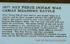 | Camas Meadow Camp and Battle Sites | site | 1989 | 89001081 |
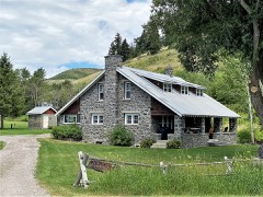 | Spencer Rock House | building | 1989 | 89001991 |
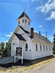 | St. James' Episcopal Mission Church | building | 1993 | 93000387 |
Every wildfire the federal occurrence database records inside this county: 187 of them, burning about 78,208 acres. 84 started naturally and 1 was recorded as arson. Each settlement page carries the fires within five miles of it.
| Reported cause | Fires |
|---|---|
| Natural | 84 |
| Recreation and ceremony | 33 |
| Missing data/not specified/undetermined | 21 |
| Equipment and vehicle use | 14 |
| Smoking | 11 |
| Debris and open burning | 11 |
| Railroad operations and maintenance | 9 |
| Power generation/transmission/distribution | 2 |
| Fireworks | 1 |
| Arson/incendiarism | 1 |
The five largest, by the area the report gives. None of them was recorded as arson.
| Date | Cause | Size | Reported by | Name on the report |
|---|---|---|---|---|
| 5 August 2003 | Natural | 37,842 acres | Idaho Falls District | DEEP |
| 12 September 2018 | Missing data/not specified/undetermined | 12,572 acres | Idaho Falls District | INDIAN BUTTE |
| 6 September 2006 | Natural | 9,677 acres | Idaho Falls District | SNOWSHOE |
| 14 August 2003 | Natural | 4,612 acres | Caribou-Targhee National Forest | WINSLOW / IDAHO |
| 18 August 2000 | Missing data/not specified/undetermined | 2,039 acres | Idaho Falls District | CATCH 22 |
| 25 August 2012 | Missing data/not specified/undetermined | 1,800 acres | Idaho Falls District | RADAR HILL |
| 2 August 2006 | Power generation/transmission/distribution | 1,652 acres | Idaho Falls District | NEZ PERCE TRAIL |
| 29 September 2008 | Natural | 1,646 acres | Caribou-Targhee National Forest | TIMBER WFU |
Every settlement page carries the fires within five miles of it - see the settlement index below.
The NOAA Storm Events Database holds 79 reports for this county, causing no deaths, no injuries and about $823,000 in recorded property damage. Each settlement page carries the reports that name it.
| Kind of event | Reports |
|---|---|
| Thunderstorm Wind | 46 |
| Hail | 10 |
| Flood | 7 |
| Tornado | 6 |
| Wildfire | 4 |
| Heavy Rain | 2 |
| Flash Flood | 2 |
| Funnel Cloud | 2 |
The most serious of them, by death, then injury, then recorded damage. The accounts are quoted exactly as the forecast office filed them.
| When | Event | Place named | Harm | What the report says |
|---|---|---|---|---|
| March 2018 | Flood | Kilgore | $680,000 | Snow melt began in earnest with warmer temperatures combined with periods of heavy rain in the latter half of March. This caused extensive sheet flooding in Clark County to the extent that the governor declared it a state of Idaho disaster area. Several county roads received extensive damage and were washed away. 1 home in the Medicine Lodge area flooded completely along with hay bail damage and crop damage. The Birch Creek Campground also had extensive damage with several campgrounds along the birch Creek washed away. The county placed damage estimates close to 700 thousand dollars. |
| February 2017 | Flood | Spencer | $67,000 | Some minor flooding and road damage occurred from a combination of snow melt with the extensive warmup during the month. |
| August 2003 | Wildfire | Dubois | $25,000 | no account filed |
| March 1991 | Tornado (F1) | not stated | $25,000 | no account filed |
| March 2017 | Flood | Spencer | $10,000 | Minor sheet flooding from snow melt continued in March but effects were minimal and mainly limited to road damage and some field flooding. |
| June 1995 | Hail | Port of Entry | $5,000 | no account filed |
| June 1995 | Tornado (F0) | not stated | $5,000 | no account filed |
| December 2025 | Flood | Small | $3,000 | Medicine Lodge Creed near Small went into flood stage around 950 PM on the 24th and reached an all time record at 1230 AM on the 25th and didn't drop below flood stage until 545 AM on the 25th. Two road washouts occurred. One was near the convergence of Medicine Lodge and Middle Creeks. The second was a mile further into the canyon where the Medicine Lodge Creek was flowing over the road. Four to five families were affected by the washouts. Twelve hour rainfall amounts ranged in the 1 to 2 inch range in the flood area. The highest amount was 1.81 inches 9 miles northwest of Small. The flooding area was 3 to 10 miles northwest of Small. |
| June 1997 | Tornado (F0) | Dubois | $3,000 | A tornado briefly touched down taking shingles off a home and destroying a 24X30' shed. The tornado was observed by two people; one in the home damaged with another about 1/2 mile to the southeast. |
| April 2026 | Thunderstorm Wind | Small | - | The Medicine Lodge mesonet site recorded a 58 mph thunderstorm outflow wind gust. |
| May 2025 | Thunderstorm Wind | Small | - | Medicine Lodge mesonet recorded a 70 mph wind gust. |
| May 2025 | Thunderstorm Wind | Small | - | Medicine Lodge mesonet site PC371 recorded 70 mph wind gust. |
| May 2025 | Thunderstorm Wind | Small | - | Medicine Lodge mesonet site recorded a 67 mph wind gust. |
| May 2025 | Thunderstorm Wind | Dubois | - | A 68 mph wind gust measured at the mesonet station Reno Gulch. |
| June 2025 | Thunderstorm Wind | Small | - | A 58 mph wind gust recorded at the Medicine Lodge mesonet site. |
| June 2025 | Thunderstorm Wind | Spencer | - | A 60 mph thunderstorm outflow measured at the Blue Dome mesonet site. |
| August 2025 | Thunderstorm Wind | Dubois | - | A 58 mph wind gust measured at the Blue Dome mesonet site. |
| July 2025 | Thunderstorm Wind | Small | - | The Medicine Lodge mesonet site recorded a 65 mph wind gust. |
| July 2025 | Thunderstorm Wind | Small | - | The Medicine Lodge mesonet station recorded a thunderstorm outflow wind gust of 65 mph. |
| July 2025 | Thunderstorm Wind | Small | - | A 58 mph thunderstorm wind gust measured at Medicine Lodge mesonet site. |
| July 2025 | Thunderstorm Wind | Dubois | - | The Dubois mesonet site measured a 62 mph thunderstorm outflow wind. |
| September 2025 | Thunderstorm Wind | Dubois | - | PACIFICORP station PC374 Reno Gulch measured a 58 mph thunderstorm outflow wind. |
| July 2024 | Thunderstorm Wind | Small | - | A 60 mph wind gust measured at BLU Blue Dome site. |
| July 2024 | Thunderstorm Wind | Dubois | - | A 61 mph wind gust measured at Reno Gulch mesonet site. |
| April 2024 | Thunderstorm Wind | Small | - | A 58 mph microburst occurred at Medicine Lodge mesonet station. |
| September 2024 | Thunderstorm Wind | Dubois | - | A 59 mph thunderstorm outflow wind measured at Blue Dome. |
| September 2024 | Thunderstorm Wind | Small | - | A 60 mph thunderstorm outflow was recorded at Medicine Lodge. |
| September 2024 | Thunderstorm Wind | Humphrey | - | A 59 mph thunderstorm outflow wind measured at Monida Pass on interstate 15. |
| September 2024 | Thunderstorm Wind | Small | - | A 62 mph thunderstorm outflow wind measured at Medicine Lodge. |
| September 2024 | Thunderstorm Wind | Small | - | A 58 mph wind gust measured at Medicine Lodge PC371. |
| August 2024 | Thunderstorm Wind | Small | - | Mesonet site Medicine Lodge recorded a 60 mph thunderstorm outflow wind gust. |
| August 2024 | Thunderstorm Wind | Small | - | A wind gust of 62 mph measured at Medicine Lodge. |
| June 2023 | Funnel Cloud | Dubois | - | Funnel cloud photographed in Dubois. |
| August 2023 | Thunderstorm Wind | Small | - | The Medicine Lodge mesonet site measured a 79 mph wind gust. |
| August 2023 | Thunderstorm Wind | Dubois | - | A 78 mph wind gust measured at Reno gulch Pacific Corp mesonet site. |
| August 2023 | Thunderstorm Wind | Small | - | A 61 mph wind gust at Medicine Lodge. |
| July 2022 | Thunderstorm Wind | Dubois | - | Private weather station measured a 62 mph wind gust in Dubois at the intersection of Main St and Oakley Ave. |
| July 2022 | Thunderstorm Wind | Humphrey | - | A thunderstorm outflow wind gust of 63 mph was measured at the Monida Pass ITD mesonet site. |
| June 2022 | Funnel Cloud | Dubois | - | A funnel cloud photographed near Dubois. |
| July 2021 | Thunderstorm Wind | Spencer | - | A 64 mph wind gust was measured at the China Point ITD site. |
| July 2021 | Thunderstorm Wind | Dubois | - | A 70 mph wind gust was measured at the Dubois ARL site. |
| July 2020 | Thunderstorm Wind | Dubois | - | A 57 mph wind gust measured at the Blue Dome Mesonet site. |
| May 2020 | Thunderstorm Wind | Dubois | - | An 83 mph wind gust measured at the Camas ITD site. |
| June 2020 | Thunderstorm Wind | Dubois | - | The Camas site recorded a 63 mph wind gust. |
| January 2017 | Flood | Small | - | Ice Jam on Birch Creek caused high water over Hwy 28 near Lone Pine on the border of Lemhi and Clark counties. |
| August 2014 | Heavy Rain | Dubois | - | Clark County was declared a natural disaster area by the USDA due to barley crop loss in August from heavy rains. Eastern Idaho lost about 64 million dollars of barley crops due to the rains with a portion of that occurring in Clark County. |
| August 2014 | Hail | Spencer | - | One inch hail reported in Spencer. |
| September 2013 | Thunderstorm Wind | Dubois | - | A 63 mph wind gust was measured at Blue Dome. |
| September 2013 | Tornado (EF0) | Dubois | - | A COOP observer witnessed a tornado with debris being lifted about 5 miles east-southeast of Dubois. Tornado was in open area with no damage occurring and path unknown. |
| July 2013 | Thunderstorm Wind | Dubois | - | A thunderstorm wind gust of 68 mph was measured at the Dubois ARL site. |
| July 2013 | Flash Flood | Spencer | - | Heavy rain in thunderstorms caused flooding of one house south of Spencer. |
| March 2012 | Flood | Dubois | - | Localized flooding occurred in Dubois from March 10th through the 17th caused by melting snow on frozen ground as well as ice jams in Beavercreek. Local flooding of streets occurred as well as some water in basements but substantial property damage was avoided. |
| May 2011 | Flood | Kilgore | - | Flooding of pasture and agricultural fields occurred. Some roads in the Kilgore area were flooded and several roads werre raised to avoid the flood waters. |
| August 2007 | Thunderstorm Wind | Dubois | - | Sixty mph winds were measured at the Dubois Mesonet site. |
| May 2005 | Tornado (F0) | Dubois | - | Tornado in open sagebrush area. No damage noted. |
| July 2001 | Flash Flood | Spencer | - | Localized flooding occurred from 1.5 to 2.0 inches of rain in 2 hours in the northern portions of the town of Spencer. |
| June 2005 | Thunderstorm Wind | Small | - | no account filed |
| August 2005 | Thunderstorm Wind | Dubois | - | no account filed |
| August 2005 | Hail | Dubois | - | no account filed |
| August 2005 | Hail | Dubois | - | no account filed |
The Survey's mineral resources record lists 103 workings inside this county. 17 still produce and 86 are closed or unrecorded. Each settlement page carries the workings within five miles of it.
| Commodity | Workings |
|---|---|
| Sand and Gravel, Construction | 51 |
| Phosphorus-Phosphates | 10 |
| Lead | 7 |
| Uranium | 6 |
| Silver | 5 |
| Limestone, General | 4 |
| Copper | 3 |
| Geothermal | 3 |
| Vanadium, Uranium, Fluorine-Fluorite | 2 |
| Iron | 2 |
| Silver, Lead | 2 |
| Bentonite | 2 |
| Silver, Gold | 2 |
| Gold | 2 |
The least common of them first, because a county's hundredth gravel pit says nothing its first ten did not.
| Where | Site | Commodity | Status | Recorded |
|---|---|---|---|---|
| Bare and Chastaine | Copper, Gold, Silver | Prospect | ||
| Beaverhead Claims No.1,2,3,&4 | Lead, Silver, Gold, Copper, Zinc | Unknown | ||
| Birch Creek | Silver, Gold, Lead, Zinc | Unknown | ||
| Birch Creek District | Silver, Zinc, Copper, Lead | Producer | REPLACEMENT | |
| Carrot Ridge Area Phosphate Deposit | Phosphorus-Phosphates, Uranium, Fluorine-Fluorite, Vanadium | Prospect | ||
| Lidy Hot Springs Occurrence | Uranium, Thorium | Occurrence | ||
| Limestone Occurrence | Limestone, Dimension | Unknown | ||
| Lone Pine Group | Antimony, Silver, Gold | Prospect | ||
| Opal Mountain Mine | Gemstone | Past Producer | ||
| Prospect | Clay | Occurrence | ||
| Sagebrush Prospect | Lead, Zinc, Silver | Prospect | ||
| Scott Mine | Silver, Lead, Zinc, Gold, Copper | Past Producer | 1885, 1888 | |
| South Slope Taylor Creek Phosphate Deposit | Uranium, Phosphorus-Phosphates, Fluorine-Fluorite, Vanadium | Occurrence | ||
| Spencer Opal Mine | Semiprecious Gemstone | Producer | ||
| Swan Butte | Pumice | Unknown | ||
| Troublesome Ridge Phosphate Deposit | Fluorine-Fluorite, Uranium, Phosphorus-Phosphates, Vanadium | Occurrence | ||
| Bald Mountain Phosphate Deposit | Phosphorus-Phosphates, Vanadium, Uranium, Fluorine-Fluorite | Occurrence | ||
| Bentonite Occurrence | Bentonite | Occurrence | Bentonite | |
| Bentonite Occurrence | Bentonite | Occurrence | Bentonite | |
| Bentonite Occurrence | Stone, Dimension | Unknown | ||
| Birch Creek | Iron | Past Producer | ||
| Centennial Phosphate Mine | Phosphorus-Phosphates, Vanadium, Uranium, Fluorine-Fluorite | Past Producer | 1956 | |
| First Discovery Claim | Uranium, Silver, Lead | Prospect | ||
| Fritz Creek | Stone, Dimension | Past Producer | ||
| Heart Creek Adit | Gold, Silver | Prospect | ||
| Kilgore | Gold | Prospect | ||
| Peterson Mine | Iron | Past Producer | 1925 | |
| Weimer Mine | Copper, Silver, Gold, Lead | Past Producer | 1885, 1890 | |
| Lidy Hot Springs | Geothermal | Occurrence | ||
| Pocahontas Claims | Copper | Past Producer | ||
| Thermal Spring | Geothermal | Occurrence | ||
| Unnamed Warm Spring | Geothermal | Occurrence | ||
| Fritz Creek Travertine Mine | Limestone, General | Past Producer | Calcite, Travertine | |
| Lidy Hot Springs Limestone | Limestone, General | Unknown | ||
| Montana Travertine Company | Limestone, General | Past Producer | ||
| White Rock | Limestone, General | Past Producer | ||
| Canyon West | Silver | Prospect | ||
| Hill No. 3 Prospect | Lead, Silver | Past Producer | Vein | |
| Rainbow Hill | Lead, Silver | Prospect | ||
| Elkhorn | Uranium | Occurrence | ||
| Iron Blowout Prospect | Uranium | Unknown | ||
| Long Canyon | Uranium | Unknown | ||
| Myers Creek Area-Elkhorn Group | Uranium | Occurrence | ||
| Bald Mountain Gulch Prospect | Lead | Prospect | ||
| Worthing Prospect | Lead | Prospect | Galena | |
| Blue Dome | Phosphorus-Phosphates | Prospect | ||
| East Dry Creek Phosphate Mine | Phosphorus-Phosphates | Past Producer | ||
| Taylor Creek Area | Phosphorus-Phosphates | Occurrence | ||
| Taylor Creek Area | Phosphorus-Phosphates | Occurrence | ||
| Taylor Creek Phosphate Mine | Phosphorus-Phosphates | Past Producer | ||
| Unnamed Phosphate Mine | Phosphorus-Phosphates | Past Producer | ||
| Unnamed Phosphate Mine | Phosphorus-Phosphates | Past Producer | ||
| Borrow Pit | Sand and Gravel, Construction | Unknown | ||
| Borrow Pit | Sand and Gravel, Construction | Unknown | ||
| Borrow Pit | Sand and Gravel, Construction | Unknown | ||
| Borrow Pit | Sand and Gravel, Construction | Unknown | ||
| Borrow Pit | Sand and Gravel, Construction | Unknown | ||
| Borrow Pit | Sand and Gravel, Construction | Unknown | ||
| Borrow Pit | Sand and Gravel, Construction | Unknown | ||
| Borrow Pit | Sand and Gravel, Construction | Unknown | ||
| Borrow Pit | Sand and Gravel, Construction | Unknown | ||
| Borrow Pit | Sand and Gravel, Construction | Unknown | ||
| Borrow Pit | Sand and Gravel, Construction | Unknown | ||
| Borrow Pit | Sand and Gravel, Construction | Unknown | ||
| Borrow Pit | Sand and Gravel, Construction | Unknown | ||
| Borrow Pit | Sand and Gravel, Construction | Unknown | ||
| Borrow Pit | Sand and Gravel, Construction | Unknown | ||
| Borrow Pit | Sand and Gravel, Construction | Unknown | ||
| Gravel Pit | Sand and Gravel, Construction | Producer | ||
| Gravel Pit | Sand and Gravel, Construction | Unknown | ||
| Gravel Pit | Sand and Gravel, Construction | Producer | ||
| Gravel Pit | Sand and Gravel, Construction | Producer | ||
| Gravel Pit | Sand and Gravel, Construction | Unknown | ||
| Gravel Pit | Sand and Gravel, Construction | Producer | ||
| Gravel Pit | Sand and Gravel, Construction | Producer | ||
| Gravel Pit | Sand and Gravel, Construction | Unknown | ||
| Gravel Pit | Sand and Gravel, Construction | Unknown | ||
| Gravel Pit | Sand and Gravel, Construction | Unknown | ||
| Gravel Pit | Sand and Gravel, Construction | Unknown | ||
| Gravel Pit | Sand and Gravel, Construction | Unknown | ||
| Gravel Pit | Sand and Gravel, Construction | Unknown | ||
| Gravel Pit | Sand and Gravel, Construction | Unknown | ||
| Gravel Pit | Sand and Gravel, Construction | Producer | ||
| Gravel Pit | Sand and Gravel, Construction | Producer | ||
| Gravel Pit | Sand and Gravel, Construction | Producer | ||
| Gravel Pit | Sand and Gravel, Construction | Unknown | ||
| Gravel Pit | Sand and Gravel, Construction | Unknown | ||
| Gravel Pit | Sand and Gravel, Construction | Past Producer | ||
| Gravel Pit | Sand and Gravel, Construction | Past Producer | ||
| Gravel Pit | Sand and Gravel, Construction | Producer | ||
| Gravel Pit | Sand and Gravel, Construction | Producer | ||
| Gravel Pit | Sand and Gravel, Construction | Unknown | ||
| Gravel Pit | Sand and Gravel, Construction | Producer | ||
| Gravel Pit | Sand and Gravel, Construction | Unknown | ||
| Gravel Pit | Sand and Gravel, Construction | Past Producer | ||
| Gravel Pit | Sand and Gravel, Construction | Producer | ||
| Gravel Pit | Sand and Gravel, Construction | Producer | ||
| Gravel Pit | Sand and Gravel, Construction | Unknown | ||
| Gravel Pit | Sand and Gravel, Construction | Past Producer | ||
| Gravel Pit | Sand and Gravel, Construction | Unknown | ||
| Gravel Pit | Sand and Gravel, Construction | Producer | ||
| Gravel Pit | Sand and Gravel, Construction | Producer | ||
| Gravel Pit | Sand and Gravel, Construction | Unknown |
Named settlements recorded in the Geographic Names Information System, each with the topographic sheets covering it. Villages, hamlets and abandoned places alike. Each is shown with the nearest named watercourse or landform and the survey quadrangle it falls on.
West Clark census division · 83464 · Near Skull Canyon · Blue Dome quadrangle
8 sheets, 1955 to 1983
East Clark census division · 83423 · On Dry Creek · Spencer South quadrangle
8 sheets, 1955 to 1983
East Clark census division · 83423 · On Robbins Creek · Spencer North quadrangle
8 sheets, 1955 to 1983
West Clark census division · 83464 · Near Skull Canyon · Blue Dome quadrangle
8 sheets, 1955 to 1983
No longer a settlement
East Clark census division · 83423 · On Warm Creek · Kilgore quadrangle
9 sheets, 1955 to 1989
West Clark census division · 83423 · Lidy Hot Springs quadrangle
8 sheets, 1955 to 1983
West Clark census division · 83464 · Near Bruce Canyon · Blue Dome quadrangle
8 sheets, 1955 to 1983
East Clark census division · 83423 · On Dairy Creek · Spencer North quadrangle
8 sheets, 1955 to 1983
East Clark census division · 83446 · Near Huntley Canyon · Spencer South quadrangle
8 sheets, 1955 to 1983
West Clark census division · 83423 · On Blue Creek · Lidy Hot Springs quadrangle
8 sheets, 1955 to 1983
The vanished settlements of Clark County: the places named above that are no longer on the map.