
BlockBefore
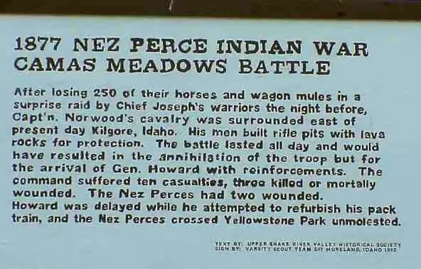
Photograph of Camas Meadows Battle Sites
Photograph by Philkon Phil Konstantin, Public domain. Via Wikimedia Commons.

Camas Meadow Camp and Battle Sites

A National Historic Landmark. Listed on the National Register of Historic Places in 1989.

From the record

“The Camas Meadows Battle Sites, also known as Camas Meadows Camp and Battle Sites, are two sites important to the Battle of Camas Creek, fought August 20, 1877 between members of the Nez Perce tribe and troops of the United States Army. The Nez Perce captured about 150 horses and mules from a campsite of the pursuing army, and for several hours besieged a detachment sent to recover them at a second site.”

Wikipedia article Camas Meadows Battle Sites, CC BY-SA 4.0.

One of 3 National Register listings published here for Clark County · listed in 1989 · category: Site · a National Historic Landmark.

Sources: the Wikipedia article · the case file at the National Archives · the National Register database, National Park Service

The listing

  • Address. E of Kilgore, Kilgore
  • When was it listed? April 1989
  • Category. site
  • Census division. East Clark
  • National Register reference number. 89001081 - the number the National Park Service assigned this property when it was listed, and the key its nomination file is catalogued under at the National Archives.

Mines and quarries near this property

1 within 5 miles

Regional context, not property-specific evidence. The federal mineral resources record lists 1 working within 5 miles of Camas Meadow Camp and Battle Sites: 1 producer. All of them still produce. What was taken out: Sand and Gravel, Construction. Distance is straight-line from the map coordinates, so a quarry counted here may appear on a neighbouring settlement's page as well.

Where SiteCommodity StatusRecorded
Gravel PitSand and Gravel, ConstructionProducer

Every working recorded in Clark County

Storms near this property

5 since 1996

Regional context, not property-specific evidence. The National Weather Service names Kilgore, the town this property stands in, in 5 storm reports between 1996 and 2018: 2 flood, 1 heavy rain, 1 hail, 1 wildfire. No death or injury is recorded in these reports. Each account below is quoted exactly as the forecast office filed it, from the NOAA Storm Events Database, and each date opens the federal record of that event.

WhenEvent Place namedHarm What the report says
March 2018FloodKilgore$680,000Snow melt began in earnest with warmer temperatures combined with periods of heavy rain in the latter half of March. This caused extensive sheet flooding in Clark County to the extent that the governor declared it a state of Idaho disaster area. Several county roads received extensive damage and were washed away. 1 home in the Medicine Lodge area flooded completely along with hay bail damage and crop damage. The Birch Creek Campground also had extensive damage with several campgrounds along the birch Creek washed away. The county placed damage estimates close to 700 thousand dollars.
May 2011FloodKilgore-Flooding of pasture and agricultural fields occurred. Some roads in the Kilgore area were flooded and several roads werre raised to avoid the flood waters.
September 2003WildfireKilgore-no account filed
August 2002HailKilgore-no account filed
July 1996Heavy RainKilgore-no account filed

Every storm recorded in Clark County

Map coverage status

No historic map-sheet match is published for this property yet. That does not mean no map exists. This record needs a coordinate-quality review before it can be joined to a sheet boundary. Browse the county's mapped places while that work is pending.

Sources for this property

National Archives recordThe nomination case file for reference 89001081 in Record Group 79.
Wikipedia articleCommunity-written account of this property, licensed CC BY-SA.
Clark CountyAll 3 listed properties in this county.

Provenance

  • Listing record. National Park Service National Register of Historic Places, listed-properties dataset, current to 2026-05-22.
  • Map join. Address geocoded through the United States Census geocoder, then tested against the published boundary of every sheet in the USGS Historical Topographic Map Collection.
  • How this page is made. Listing fields come from federal records; map-sheet coverage is a labelled coordinate-to-boundary calculation, not a source-field claim.
  • Mines and quarries. USGS Mineral Resources Data System (MRDS) https://mrdata.usgs.gov/mrds/ A work of the United States government, no copyright under 17 U.S.C. 105.
  • Storms. NOAA National Centers for Environmental Information, Storm Events Database https://www.ncei.noaa.gov/stormevents/ A work of the United States government, no copyright under 17 U.S.C. 105. Narratives are quoted verbatim from the National Weather Service report and are not edited or summarised.