 Block
From the record
6 National Register listings published here.
Sources: the National Register database, National Park Service
51 topographic sheets cover 23 settlements here, and 6 properties are on the National Register of Historic Places.
6 National Register listings published here.
Sources: the National Register database, National Park Service
Every property in this county listed on the National Register of Historic Places, with the year it was listed and the federal nomination document.
| Photograph | Property | Type | Listed | Reference |
|---|---|---|---|---|
 | Hotel Patrie | building | 1978 | 78001068 |
 | Jefferson County Courthouse | building | 1987 | 87001586 |
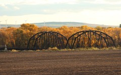 | Ririe A Pegram Truss Railroad Bridge | structure | 1997 | 97000759 |
| Ririe B Pegram Truss Railroad Bridge | structure | 1997 | 97000760 | |
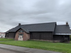 | Ririe Community Hall | building | 2019 | 100003924 |
| Josiah Scott House | building | 1982 | 82000387 |
Every wildfire the federal occurrence database records inside this county: 99 of them, burning about 173,761 acres. 33 started naturally and 4 were recorded as arson. Each settlement page carries the fires within five miles of it.
| Reported cause | Fires |
|---|---|
| Natural | 33 |
| Missing data/not specified/undetermined | 14 |
| Equipment and vehicle use | 13 |
| Debris and open burning | 9 |
| Power generation/transmission/distribution | 8 |
| Firearms and explosives use | 6 |
| Arson/incendiarism | 4 |
| Fireworks | 4 |
| Recreation and ceremony | 4 |
| Other causes | 2 |
| Smoking | 1 |
| Railroad operations and maintenance | 1 |
The five largest, by the area the report gives. None of them was recorded as arson.
| Date | Cause | Size | Reported by | Name on the report |
|---|---|---|---|---|
| 22 July 2019 | Natural | 112,107 acres | Idaho Falls District | SHEEP |
| 25 August 2017 | Equipment and vehicle use | 17,588 acres | Idaho Falls District | DEER PARK |
| 12 August 2003 | Natural | 12,068 acres | Idaho Falls District | MENAN 2 |
| 17 August 2000 | Power generation/transmission/distribution | 7,156 acres | Idaho Falls District | CAMAS |
| 7 August 1994 | Natural | 4,600 acres | Boise National Forest | BEAR RIVER |
| 11 August 2019 | Natural | 4,538 acres | Idaho Falls District | DESERT RIDE |
| 17 June 1994 | Power generation/transmission/distribution | 2,484 acres | Idaho Falls District | KETTLE BTE |
| 25 July 2018 | Natural | 2,337 acres | Idaho Falls District | DEVILS HOLE |
Every settlement page carries the fires within five miles of it - see the settlement index below.
The NOAA Storm Events Database holds 234 reports for this county, causing no deaths, 1 injury and about $3,836,800 in recorded property damage. Each settlement page carries the reports that name it.
| Kind of event | Reports |
|---|---|
| Thunderstorm Wind | 170 |
| Hail | 29 |
| Tornado | 18 |
| Flood | 10 |
| Funnel Cloud | 3 |
| Wildfire | 1 |
| Flash Flood | 1 |
| Heavy Rain | 1 |
| Lightning | 1 |
The most serious of them, by death, then injury, then recorded damage. The accounts are quoted exactly as the forecast office filed them.
| When | Event | Place named | Harm | What the report says |
|---|---|---|---|---|
| July 1992 | Thunderstorm Wind | not stated | 1 hurt | no account filed |
| February 2017 | Flood | Camas | $2,430,000 | A significant warmup in February caused massive sheet flooding from snowfall accumulation from December and January. Extensive damage occurred to homes and especially road damage. The state declared Jefferson County a disaster area due to the magnitude of the damage. Road flooding occurred near Roberts on the 11th and 12th, but extreme flooding commenced after the 19th mainly west of Interstate 15. 600 North was closed from 2450 East to 2300 East. 400 North was closed from 2400 East to 1800 East. 2300 East was closed from County Line to 400 North. 2100 East was closed from County Line to 400 North. 2600 East was closed from 200 North to 400 North and 1800 East was closed from 400 North to 1200 North. Water on some roads reached levels that caused automobiles to float. Road crews described some roads similar to waterfalls. |
| March 2017 | Flood | Camas | $435,000 | Extensive road and property damage continued into March. Many roads in the Roberts area suffered severe damage due to the flooding. Multiple personal water wells had e-coli due to the problems from the flooding in the first week of March. This occurred near E 200 N and N 3300 E southwest of Lewisville. |
| April 2023 | Flood | Roberts | $126,500 | The beginning of snowmelt season brought some initial sheet flooding to Jefferson County with road and bridge damage and surrounding some homes Minimal damage occurred to the homes with about 126 thousand dollars of road and bridge damage. |
| June 2024 | Thunderstorm Wind | Lorenzo | $100,000 | Ten power poles downed, numerous power pole cross arms broken, and at least 15 large trees downed, some snapped at various heights and some uprooted, along E 600 N between N 3950 E and N 4062 E. One large tree fell through the bedroom of a residence. |
| May 2018 | Flood | Lorenzo | $100,000 | Seasonal snow melt flooding along with heavy rain caused significant damage to the levee near Lorenzo as it was eroding 500 feet per day. The Snake River and Henry's Fork of the Snake flowed at action stage for several weeks causing the event. Jefferson County declared disaster as it was costing 9,000 dollars per day for seven days. The County used all of their 40,000 dollars for the repairs to the levee and required further assistance from the US Corps of Engineers. |
| April 2018 | Thunderstorm Wind | Annis | $90,000 | Outflow winds from severe thunderstorms caused extensive property damage in Jefferson County with damage estimates at $90,000. |
| January 2000 | Thunderstorm Wind | Countywide | $60,000 | Strong winds to 50 mph and hail of unknown size resulted widespread crop damage. An estimated 35-40,000 acres of alfalfa, wheat and other crops were damaged or destroyed. Winds also topped a 60 foot high grain silo made of corrugated steel. |
| July 2000 | Thunderstorm Wind | Countywide | $60,000 | Thunderstorm winds to 50 mph and hail of unknown diameter cut a swath through some 10% of the crops in Jefferson county. About 40,000 acres of alfalfa, wheat of other crops were damaged or flattened. Winds toppled and destroyed a 60 foot grain silo. |
| June 2002 | Tornado (F1) | Roberts | $60,000 | no account filed |
| May 2017 | Flood | Camas | $38,000 | Minor flooding continued throughout May with field flooding causing agricultural damage along with money needed for levee repair and recreation facilities. |
| August 2005 | Thunderstorm Wind | Rigby | $35,000 | no account filed |
| June 1992 | Tornado (F1) | not stated | $25,000 | no account filed |
| June 1991 | Tornado (F1) | not stated | $25,000 | no account filed |
| July 1980 | Tornado (F1) | not stated | $25,000 | no account filed |
| April 2020 | Thunderstorm Wind | Rigby | $15,000 | Thunderstorm winds caused major damage to vehicles at Tadd Jenkins Chevrolet in Rigby. Thunderstorm driven winds picked up rocks and shattered the windows on 15 vehicles with 20 to 30 other vehicles with other rock damage caused by the winds. Damage was estimated near 15,000 dollars. |
| June 2017 | Flood | Camas | $13,000 | Minor flooding continued throughout the first half of June with field flooding causing agricultural damage along with money needed for levee repair and recreation facilities. |
| June 2024 | Thunderstorm Wind | Lorenzo | $12,000 | Two very large trees uprooted along N 3950 Ed, one measured at 4 feet in diameter and another 3.5 feet in diameter, along with 1 power pole down. At least 7 additional trees down along Long Island Canal. A local farmer reported approximately 20 sheep killed due to falling trees. |
| October 2025 | Tornado (EF0) | Rigby | $10,000 | A brief EF0 tornado touched down at 1:45 pm MDT to 1:50 pm MDT near Rigby, Idaho. Multiple funnel cloud sightings were reported with damage at one property along N 3950 E. A survey revealed tree and property damage consistent with 75 to 85 mph winds including two large uprooted pine trees, a recreation vehicle flipped on its side, a damaged outbuilding, and a destroyed partially constructed sunroom attachment on the residence. |
| June 2024 | Thunderstorm Wind | Rigby | $10,000 | Multiple vehicles damaged by falling trees at a wedding at The Millhouse Venue, with significant dents and smashed windshields. |
| June 2011 | Flood | Rigby | $10,000 | High flows on the Snake River flooded over 1,100 acres of cropland. The Menan Buttes Public Access boat ramp and a recreational day use area and boat ramp adjacent to Highway 48 remained flooded. A power line which under the river near Lorenzo was unburied and snapped due to the high flows. |
| February 2000 | Thunderstorm Wind | Countywide | $10,000 | One home was damaged. |
| August 2024 | Thunderstorm Wind | Ririe | $9,000 | Jefferson County Dispatch reported multiple trees down across far eastern Jefferson County. No injuries or fatalities reported. |
| October 2016 | Hail | Rigby | $9,000 | A fast moving hail storm caused multiple cars to slide off Highway 20 south in Rigby causing traffic to be blocked for miles in the southbound lanes. Several vehicles were involved including one rollover and an RV and semi-truck. |
| June 2024 | Thunderstorm Wind | Lorenzo | $8,000 | Multiple large trees uprooted in the area of E 600 N and N 4100 E. Trees down on at least two homes with a hole in the side of one home. |
| June 2024 | Thunderstorm Wind | Rigby | $8,000 | Five to 6 trees downed at Jefferson Hills golf course with additional trees downed at nearby residences. |
| June 2024 | Thunderstorm Wind | Menan | $8,000 | Four trees snapped off and down at the intersection of E 700 N and N 3700 E with several pieces of siding removes from residence and small twigs and branches impaled into the siding on one side and one tree down on a roof. |
| June 2024 | Thunderstorm Wind | Menan | $7,000 | A livestock outbuilding constructed of wooden beams, wooden poles, and sheet metal destroyed along N 3800 E and just south of E 800 N. Multiple trees and large tree limbs down in the area. |
| June 2024 | Thunderstorm Wind | Lorenzo | $6,000 | Area of significant tree damage with numerous trees down and wires down at the intersection of N Yellowstone Highway and E 550 N. At least 4 trees measured at 3 to 4 feet in diameter uprooted and down across Yellowstone Highway with multiple other smaller trees down. |
| May 2025 | Thunderstorm Wind | Rigby | $5,000 | Several trees uprooted at Rigby Pioneer Cemetery in Rigby. |
| June 2024 | Thunderstorm Wind | Menan | $5,000 | Multiple trees down from Menan, to Annis to Lorenzo along Menan Lorenzo Highway. Multiple trees downd, damage to residential siding, power lines down. |
| August 2024 | Thunderstorm Wind | Heise | $5,000 | Emergency Management reported tree downed on vehicle on Kelly Canyon Rd with vehicle on fire. |
| August 2024 | Thunderstorm Wind | Lorenzo | $5,000 | Jefferson County Emergency Manager reported multiple trees down in the area of E Menan Lorenzo Highway and N 3950 E. |
| June 2005 | Tornado (F0) | Terreton | $5,000 | Tornado in Mud Lake area. Several trees downed and one tractor moved across highway and rolled over. |
| July 1995 | Thunderstorm Wind | Mud Lake | $5,000 | Strong winds at Mud Lake uprooted trees, blew shingles from roofs, destroyed crops and gardens, and moved any loose objects. |
| June 2024 | Thunderstorm Wind | Lorenzo | $4,000 | Large tree over 2 feet in diameter snapped off and down on top of a dump truck. |
| August 2023 | Thunderstorm Wind | Lewisville | $4,000 | Rocky Mountain Power reported 2,800 customers without power in the Lewisville area due to thunderstorm winds with some trees downed on power lines. |
| June 2024 | Thunderstorm Wind | Lorenzo | $3,000 | A large tree downed partially destroying a trailer home. |
| August 2024 | Thunderstorm Wind | Ririe | $3,000 | Large tree limbs broken off in Ririe and fell into roads. One tree was downed on wires. |
| August 2024 | Thunderstorm Wind | Lorenzo | $3,000 | Trees downed along E 600 N reported by social media. |
| August 2023 | Thunderstorm Wind | Lewisville | $3,000 | Multiple trees downed along and off of Old Highway 91 and Bassett Road. |
| April 1988 | Tornado (F1) | not stated | $2,500 | no account filed |
| April 1988 | Tornado (F1) | not stated | $2,500 | no account filed |
| June 1987 | Tornado (F0) | not stated | $2,500 | no account filed |
| April 1985 | Tornado (F1) | not stated | $2,500 | no account filed |
| July 2025 | Thunderstorm Wind | Monteview | $2,000 | Power lines reported damaged near Monteview with multiple power outages reported. |
| August 2024 | Thunderstorm Wind | Rigby | $2,000 | A large tree snapped off and down partially on a shed and home. |
| August 2023 | Thunderstorm Wind | Menan | $2,000 | Two trees at least 1 foot in diameter snapped off at base. |
| August 2023 | Thunderstorm Wind | Lewisville | $2,000 | A flagpole was broken at the base, one tree uprooted, and one tree split in half with numerous tree limbs down along N 3200 E near Idaho Highway 48. |
| August 2023 | Thunderstorm Wind | Rigby | $2,000 | Large trees and power lines downed on a house in Rigby. Residence damage was minimal. |
| August 2023 | Thunderstorm Wind | Hamer | $2,000 | Power lines down along Camas Creek Rd near Hamer Elementary School. |
| August 2021 | Thunderstorm Wind | Roberts | $2,000 | Power lines reported down near Roberts. |
| May 2011 | Flood | Terreton | $2,000 | Extensive road damage and washouts occurred along Kelly Canyon Road. Extensive lawland and agricultural field flooding occurred and a few properties had minor flooding in yards. One home 3 miles east of Roberts just off Highway 48 had water in the basement. Teh Menan Buttes Public Access boat ramp flooded and a recreational day use area and boat ramp adjacent to Highway 48 flooded. Levees were raised in the Roberts area and Scotts Slough by the Menan Buttes Bridge to avoid flood waters. |
| July 2000 | Thunderstorm Wind | Countywide | $2,000 | A small shed was picked up and thrown 200 feet and trees were downed two miles east of Rigby |
| August 2024 | Thunderstorm Wind | Lorenzo | $1,500 | A tree downed on a house along 600 N between Rigby and Menan. |
| September 2022 | Thunderstorm Wind | Rigby | $1,500 | A small greenhouse was destroyed at Farnsworth Middle School just west of Rigby. Jefferson County Emergency Management reported the damage. |
| June 2024 | Thunderstorm Wind | Menan | $1,000 | Tree snapped off and down at Annis Little Butte Cemetary. |
| June 2024 | Thunderstorm Wind | Lorenzo | $1,000 | Large tree downed along E Menan Lorenzo Highway. |
| June 2024 | Thunderstorm Wind | Rigby | $1,000 | Large tree limbs down near Jefferson County Lake/Rigby Lake. |
| June 2024 | Thunderstorm Wind | Lorenzo | $1,000 | Large tree limbs down in Labelle area. |
The Survey's mineral resources record lists 64 workings inside this county. 4 still produce and 60 are closed or unrecorded. Each settlement page carries the workings within five miles of it.
| Commodity | Workings |
|---|---|
| Sand and Gravel, Construction | 53 |
| Pumice | 5 |
| Gold | 2 |
| Geothermal | 2 |
| Brick Clay | 1 |
| Gold, Silver | 1 |
The least common of them first, because a county's hundredth gravel pit says nothing its first ten did not.
| Where | Site | Commodity | Status | Recorded |
|---|---|---|---|---|
| Roberts Clay Mine | Brick Clay | Producer | Clay | |
| Spare Time Mine | Gold, Silver | Occurrence | ||
| Geothermal Location | Geothermal | Occurrence | ||
| Hawley Warm Spring | Geothermal | Occurrence | ||
| Heise Gold Placer | Gold | Past Producer | 1875 | |
| Market Lake Placer | Gold | Past Producer | Placer | |
| Cinder Pit | Pumice | Past Producer | ||
| Cinder Pit | Pumice | Past Producer | ||
| Cinder Pit | Pumice | Past Producer | ||
| Cinder Pit | Pumice | Past Producer | ||
| Cinder Pit | Pumice | Past Producer | ||
| Borrow Pit | Sand and Gravel, Construction | Past Producer | ||
| Borrow Pit | Sand and Gravel, Construction | Past Producer | ||
| Borrow Pit | Sand and Gravel, Construction | Past Producer | ||
| Borrow Pit | Sand and Gravel, Construction | Past Producer | ||
| Borrow Pit | Sand and Gravel, Construction | Past Producer | ||
| Borrow Pit | Sand and Gravel, Construction | Past Producer | ||
| Borrow Pit | Sand and Gravel, Construction | Past Producer | ||
| Borrow Pit | Sand and Gravel, Construction | Past Producer | ||
| Borrow Pit | Sand and Gravel, Construction | Past Producer | ||
| Borrow Pit | Sand and Gravel, Construction | Past Producer | ||
| Borrow Pit | Sand and Gravel, Construction | Past Producer | ||
| Borrow Pit | Sand and Gravel, Construction | Past Producer | ||
| Borrow Pit | Sand and Gravel, Construction | Past Producer | ||
| Borrow Pit | Sand and Gravel, Construction | Past Producer | ||
| Borrow Pit | Sand and Gravel, Construction | Past Producer | ||
| Borrow Pit | Sand and Gravel, Construction | Past Producer | ||
| Borrow Pit | Sand and Gravel, Construction | Past Producer | ||
| Borrow Pit | Sand and Gravel, Construction | Past Producer | ||
| Borrow Pit | Sand and Gravel, Construction | Past Producer | ||
| Borrow Pit | Sand and Gravel, Construction | Past Producer | ||
| Borrow Pit | Sand and Gravel, Construction | Past Producer | ||
| Borrow Pit | Sand and Gravel, Construction | Past Producer | ||
| Borrow Pit | Sand and Gravel, Construction | Past Producer | ||
| Borrow Pit | Sand and Gravel, Construction | Past Producer | ||
| Borrow Pit | Sand and Gravel, Construction | Past Producer | ||
| Borrow Pit | Sand and Gravel, Construction | Past Producer | ||
| Borrow Pit | Sand and Gravel, Construction | Past Producer | ||
| Gravel Pit | Sand and Gravel, Construction | Producer | ||
| Gravel Pit | Sand and Gravel, Construction | Past Producer | ||
| Gravel Pit | Sand and Gravel, Construction | Past Producer | ||
| Gravel Pit | Sand and Gravel, Construction | Past Producer | ||
| Gravel Pit | Sand and Gravel, Construction | Past Producer | ||
| Gravel Pit | Sand and Gravel, Construction | Past Producer | ||
| Gravel Pit | Sand and Gravel, Construction | Past Producer | ||
| Gravel Pit | Sand and Gravel, Construction | Past Producer | ||
| Gravel Pit | Sand and Gravel, Construction | Past Producer | ||
| Gravel Pit | Sand and Gravel, Construction | Past Producer | ||
| Gravel Pit | Sand and Gravel, Construction | Past Producer | ||
| Gravel Pit | Sand and Gravel, Construction | Past Producer | ||
| Gravel Pit | Sand and Gravel, Construction | Past Producer | ||
| Gravel Pit | Sand and Gravel, Construction | Producer | ||
| Gravel Pit | Sand and Gravel, Construction | Past Producer | ||
| Gravel Pit | Sand and Gravel, Construction | Past Producer | ||
| Gravel Pit | Sand and Gravel, Construction | Past Producer | ||
| Gravel Pit | Sand and Gravel, Construction | Producer | ||
| Gravel Pit | Sand and Gravel, Construction | Past Producer | ||
| Gravel Pit | Sand and Gravel, Construction | Past Producer | ||
| Gravel Pit | Sand and Gravel, Construction | Past Producer | ||
| Gravel Pit | Sand and Gravel, Construction | Past Producer | ||
| Gravel Pit | Sand and Gravel, Construction | Past Producer | ||
| Gravel Pit | Sand and Gravel, Construction | Past Producer | ||
| Gravel Pit | Sand and Gravel, Construction | Past Producer | ||
| Gravel Pit | Sand and Gravel, Construction | Past Producer |
Named settlements recorded in the Geographic Names Information System, each with the topographic sheets covering it. Villages, hamlets and abandoned places alike. Each is shown with the nearest named watercourse or landform and the survey quadrangle it falls on.
Lewisville-Menan census division · 83442 · Near Little Buttes · Rigby quadrangle
12 sheets, 1948 to 1988
Mud Lake-Hamer census division · 83425 · On Beaver Creek · Camas quadrangle
9 sheets, 1955 to 1983
Mud Lake-Hamer census division · 83450 · Mud Lake NW quadrangle
9 sheets, 1955 to 1980
No longer a settlement
The vanished settlements of Jefferson County: the places named above that are no longer on the map.