
BlockBefore
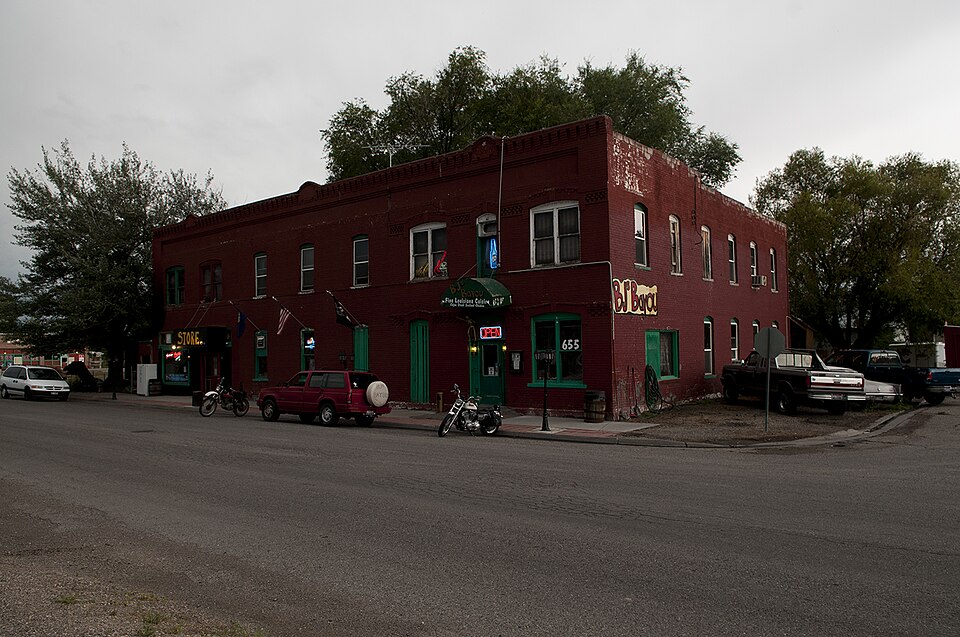
Photograph of Hotel Patrie
Photograph by Jcvanh, CC BY-SA 3.0. Via Wikimedia Commons.

Hotel Patrie

Listed on the National Register of Historic Places in 1978.

From the record

“The Hotel Patrie in Roberts, Idaho was built in 1892 and expanded in 1915 and in the 1920s. It has also been known as the Adams Hotel, as the Roberts Hotel, and as the American Hotel.”

Wikipedia article Hotel Patrie, CC BY-SA 4.0.

One of 6 National Register listings published here for Jefferson County · listed in 1978 · category: Building.

Sources: the Wikipedia article · the case file at the National Archives · the National Register database, National Park Service

The listing

  • What is counted as historic. The nomination lists 1 building as contributing to the listing.
  • Address. U.S. 91, Roberts, 83444
  • When was it listed? November 1978
  • Category. building
  • Census division. Roberts
  • National Register reference number. 78001068 - the number the National Park Service assigned this property when it was listed, and the key its nomination file is catalogued under at the National Archives.

Fires near this property

3 since 2003

Regional context, not property-specific evidence. The federal wildfire occurrence database lists 3 fires within 5 miles of Hotel Patrie between 2003 and 2018, burning about 1,951 acres in total. 1 started naturally. None was recorded as arson. Distance is straight-line from the map coordinates, so a fire counted here may appear on a neighbouring settlement's page as well.

Reported cause Fires
Railroad operations and maintenance1
Missing data/not specified/undetermined1
Natural1

The most recent of them, most recent first, with the day each was reported and the service that recorded it.

DateCause SizeReported by Name on the report
9 September 2012Missing data/not specified/undeterminedunder an acreIdaho Falls DistrictMARKET
18 August 2018Natural1,950 acresIdaho Falls DistrictARTESIAN
5 June 2003Railroad operations and maintenance1.0 acresIdaho Falls DistrictMARKET LAK

Every fire recorded in Jefferson County

Mines and quarries near this property

10 of 12 shown

Regional context, not property-specific evidence. The federal mineral resources record lists 12 workings within 5 miles of Hotel Patrie: 11 past producers, 1 producer. 1 still produces. What was taken out: Sand and Gravel, Construction, Brick Clay, Gold. Distance is straight-line from the map coordinates, so a quarry counted here may appear on a neighbouring settlement's page as well.

Where SiteCommodity StatusRecorded
Market Lake PlacerGoldPast ProducerPlacer
Roberts Clay MineBrick ClayProducerClay
Borrow PitSand and Gravel, ConstructionPast Producer
Gravel PitSand and Gravel, ConstructionPast Producer

Every working recorded in Jefferson County

Storms near this property

37 since 1997

Regional context, not property-specific evidence. The National Weather Service names Roberts, the town this property stands in, in 37 storm reports between 1997 and 2024: 23 thunderstorm wind, 7 hail, 3 funnel cloud, 2 tornado. No death or injury is recorded in these reports. Each account below is quoted exactly as the forecast office filed it, from the NOAA Storm Events Database, and each date opens the federal record of that event.

WhenEvent Place namedHarm What the report says
April 2023FloodRoberts$126,500The beginning of snowmelt season brought some initial sheet flooding to Jefferson County with road and bridge damage and surrounding some homes Minimal damage occurred to the homes with about 126 thousand dollars of road and bridge damage.
June 2002Tornado (F1)Roberts$60,000no account filed
August 2021Thunderstorm WindRoberts$2,000Power lines reported down near Roberts.
August 2023Thunderstorm WindRoberts$1,000Tree estimated at 1.5 feet in diameter snapped off several feet above the base with a second tree downed nearby.
April 2015HailRoberts$1,000Three to 6 inches of hail accumulated in Roberts. Several cars slid off roads and an INL bus got stuck in the ice. Snow plows were called out to plow the roads in the Roberts area.
May 2012Thunderstorm WindRoberts$1,000Thunderstorm winds destroyed flag pole and chicken coop at residence in Roberts and items blown 200 feet from house.
April 2020Thunderstorm WindRoberts$500Pine trees were snapped with shingles blown off a home. Occurred just north of Roberts.
August 2024Thunderstorm WindRoberts$250Large tree limb snapped off south of Roberts.
June 2024Thunderstorm WindRoberts-The Osgood ITD site measured a 60 mph wind gust.
August 2024Thunderstorm WindRoberts-Rocky Mountain Power reported power outage due to thunderstorm winds.
August 2024Funnel CloudRoberts-Received multiple reports from public and photos of funnel cloud southwest of Roberts.
August 2023Thunderstorm WindRoberts-Rocky Mountain Power reported 700 customers without power due to thunderstorm winds in the Roberts area.
August 2023Thunderstorm WindRoberts-Roberts mesonet site measured a 60 mph wind gust.
July 2022Thunderstorm WindRoberts-A thunderstorm outflow wind of 72 mph measured at the NOAA ARL Rover site.
September 2021Thunderstorm WindRoberts-A 60 mph wind gust 1 mile north of Roberts.
May 2020Thunderstorm WindRoberts-A 58 mph wind reported in Roberts.
September 2020Thunderstorm WindRoberts-Roberts ARL site recorded 57 mph wind gust.
March 2019FloodRoberts-Some flooding occurred in Jefferson County closing a few roads, but cooling temperatures eased the issue. Only minor damage occurred.
May 2018HailRoberts-An inch and a quarter sized hail fell in Roberts.
May 2018Funnel CloudRoberts-A spotter reported a funnel cloud 13 miles west of Rexburg on highway 33 at mile marker 64.
May 2018HailRoberts-Spotter reported 1 inch hail on Highway 33 at mile marker 64 thirteen miles west of Rexburg.
May 2018HailRoberts-One inch hail in Roberts.
October 2016HailRoberts-One inch hail in northwest Roberts.
October 2016Funnel CloudRoberts-Funnel cloud reported in Roberts.
October 2016Thunderstorm WindRoberts-A 68 mph wind gust at the Rover ARL site.
October 2016Thunderstorm WindRoberts-A 60 mph gust measured at the Rover ARL site.
July 2016Thunderstorm WindRoberts-A 72 mph wind gust was recorded at the Roberts ARL Site.
August 2015Thunderstorm WindRoberts-A 59 mph wind gust was measured at Roberts.
August 2014HailRoberts-One inch hail photographed and placed on social media occurred in the city of Roberts.
September 2014Thunderstorm WindRoberts-Roberts ARL mesnonet site recorded 60 mph winds.
July 2000Tornado (F0)Roberts-A brief touchdown from a weak tornado that caused no damage.
July 1997Thunderstorm WindRoberts-Wind blew 70 foot section of wall off shed.
August 2021Thunderstorm WindRoberts-no account filed
March 2006Thunderstorm WindRoberts-no account filed
August 2005HailRoberts-no account filed
May 2003Thunderstorm WindRoberts-no account filed
September 1997Thunderstorm WindRoberts-no account filed

Every storm recorded in Jefferson County

Map coverage status

No historic map-sheet match is published for this property yet. That does not mean no map exists. This record needs a coordinate-quality review before it can be joined to a sheet boundary. Browse the county's mapped places while that work is pending.

Sources for this property

National Archives recordThe nomination case file for reference 78001068 in Record Group 79.
Wikipedia articleCommunity-written account of this property, licensed CC BY-SA.
Jefferson CountyAll 6 listed properties in this county.

Provenance

  • Listing record. National Park Service National Register of Historic Places, listed-properties dataset, current to 2026-05-22.
  • Map join. Address geocoded through the United States Census geocoder, then tested against the published boundary of every sheet in the USGS Historical Topographic Map Collection.
  • How this page is made. Listing fields come from federal records; map-sheet coverage is a labelled coordinate-to-boundary calculation, not a source-field claim.
  • Wildfire. Short, Karen C. 2022. Spatial wildfire occurrence data for the United States, 1992-2020 [FPA_FOD_20221014]. 6th Edition. Fort Collins, CO: Forest Service Research Data Archive. https://doi.org/10.2737/RDS-2013-0009.6 Collected with United States Government funding and usable without additional permissions or fees.
  • Mines and quarries. USGS Mineral Resources Data System (MRDS) https://mrdata.usgs.gov/mrds/ A work of the United States government, no copyright under 17 U.S.C. 105.
  • Storms. NOAA National Centers for Environmental Information, Storm Events Database https://www.ncei.noaa.gov/stormevents/ A work of the United States government, no copyright under 17 U.S.C. 105. Narratives are quoted verbatim from the National Weather Service report and are not edited or summarised.