 Block
From the record
12 National Register listings published here.
Sources: the National Register database, National Park Service
39 topographic sheets cover 14 settlements here, and 12 properties are on the National Register of Historic Places.
12 National Register listings published here.
Sources: the National Register database, National Park Service
Every property in this county listed on the National Register of Historic Places, with the year it was listed and the federal nomination document.
| Photograph | Property | Type | Listed | Reference |
|---|---|---|---|---|
| American Falls East Shore Power Plants | building | 1976 | 76000680 | |
| American Falls Reservoir Flooded Townsite | site | 2002 | 01001480 | |
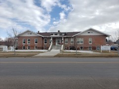 | Bethany Deaconess Hospital | building | 1995 | 95000507 |
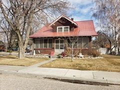 | William Davie House | building | 2008 | 08000252 |
| Oneida Milling and Elevator Company Grain Elevator | structure | 1993 | 93000380 | |
| Oregon Trail Historic District | district | 1973 | 73000688 | |
| Oregon Trail Historic District (Boundary Increase) | district | 1974 | 74002296 | |
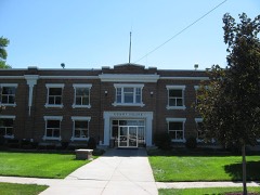 | Power County Courthouse | building | 1987 | 87001601 |
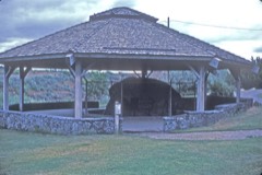 | Register Rock | object | 1978 | 78001097 |
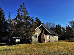 | Walter Sparks House | building | 2007 | 07000002 |
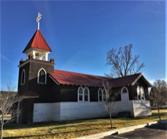 | St. John's Episcopal Church | building | 2007 | 07000004 |
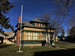 | Richard and Winnie Warwas House | building | 2006 | 06000741 |
Every wildfire the federal occurrence database records inside this county: 345 of them, burning about 538,655 acres. 212 started naturally and 13 were recorded as arson. Each settlement page carries the fires within five miles of it.
| Reported cause | Fires |
|---|---|
| Natural | 212 |
| Missing data/not specified/undetermined | 46 |
| Equipment and vehicle use | 24 |
| Arson/incendiarism | 13 |
| Power generation/transmission/distribution | 13 |
| Debris and open burning | 11 |
| Recreation and ceremony | 11 |
| Railroad operations and maintenance | 6 |
| Smoking | 5 |
| Firearms and explosives use | 3 |
| Misuse of fire by a minor | 1 |
The five largest, by the area the report gives. None of them was recorded as arson.
| Date | Cause | Size | Reported by | Name on the report |
|---|---|---|---|---|
| 15 August 2006 | Natural | 220,042 acres | Idaho Falls District | CRYSTAL |
| 4 August 2017 | Missing data/not specified/undetermined | 55,529 acres | Fort Hall Agency | POWERLINE |
| 26 July 2000 | Natural | 53,605 acres | Idaho Falls District | FLAT TOP |
| 18 September 1999 | Natural | 23,006 acres | Idaho Falls District | GRANDVIEW |
| 26 July 2000 | Natural | 17,479 acres | Idaho Falls District | FISHER SPG |
| 31 August 1998 | Natural | 12,606 acres | Idaho Falls District | EAGLE #2 |
| 5 August 2010 | Natural | 12,474 acres | Idaho Falls District | ROOSTER ROCK |
| 26 July 2000 | Natural | 11,414 acres | Idaho Falls District | MOONSHINE |
Every settlement page carries the fires within five miles of it - see the settlement index below.
The NOAA Storm Events Database holds 196 reports for this county, causing no deaths, no injuries and about $1,449,000 in recorded property damage. Each settlement page carries the reports that name it.
| Kind of event | Reports |
|---|---|
| Thunderstorm Wind | 94 |
| Hail | 29 |
| Flash Flood | 28 |
| Tornado | 17 |
| Heavy Rain | 10 |
| Funnel Cloud | 10 |
| Wildfire | 4 |
| Flood | 4 |
The most serious of them, by death, then injury, then recorded damage. The accounts are quoted exactly as the forecast office filed them.
| When | Event | Place named | Harm | What the report says |
|---|---|---|---|---|
| February 2000 | Tornado (F0) | American Falls | $375,000 | A large metal farm building was damaged 6W of Pocatello airport: siding pushed in and roof partially removed. Nearby, a cinder block and a steel framed potato storage buildings collapsed. A large grain silo sustained severe damage. A recreation fee building destroyed and several large trees downed at Willow Bay county park. Throughout the tornado's path, irrigations center pivots flipped and wheel line systems twisted. |
| February 2017 | Flood | Roy | $329,000 | A warmup in February caused extensive sheet flooding throughout Power County damaging roads and closing many of them in the 8th through 12th time period. Teh Interstate 86 exit 44 for Seagull Bay was closed due to water on the roadway along with several county roads as well. |
| August 1990 | Tornado (F2) | not stated | $250,000 | no account filed |
| March 2006 | Thunderstorm Wind | American Falls | $75,000 | no account filed |
| February 2000 | Thunderstorm Wind | Countywide | $70,000 | Two homes sustained roof damage. Ten wheel line irrigations systems were damaged. |
| March 2006 | Thunderstorm Wind | American Falls | $70,000 | no account filed |
| July 1999 | Tornado (F1) | Pocatello Arpt | $50,000 | The tornado was observed by NWS personnel on duty at the weather office as it touched down at the Bannock Peak Trading Post off Interstate 86. The tornado caused a tractor-trailer to tip onto its side, blow windows out of the truck and a motor home as well as damaging four other vehicles. As the tornado skipped along its path it was readily seen by hundreds of people in the city of Pocatello some 13 miles to the east. |
| March 2006 | Thunderstorm Wind | Michaud | $30,000 | no account filed |
| October 2019 | Thunderstorm Wind | American Falls | $25,000 | About 30 large hardwood trees either uprooted or snapped due to a likely microburst. One tree caused moderate damage to a RV, while another destroyed a pickup truck parked nearby. Another tree fell onto a baseball field fence. An open ended trailer rolled one turn on it's side significantly damaging it. A nearby heavy metal picnic table was flipped and shingle damage noted on a marina facilities building. |
| March 2017 | Flood | Roy | $25,000 | Flooding continued in March although the severity decreased substantially from February. Had a lot of minor basement flooding and damage and continued road damage from the snow melt. |
| May 1964 | Tornado (F1) | not stated | $25,000 | no account filed |
| December 2025 | Thunderstorm Wind | American Falls | $15,000 | A semi was blown over on interstate 86 near exit 44. |
| August 2023 | Flash Flood | American Falls | $15,000 | Over 2 inches of rain fell in a 3 hour period in American Falls resulting in flash flooding. Pocatello Avenue flooded with water coming halfway up tires. The construction site at American Falls High School flooded with sandbags required. Multiple houses flooded as storm drains could not catch up with the heavy rainfall. |
| September 2012 | Thunderstorm Wind | American Falls | $10,000 | Idaho Power lost three 60 foot towers near East Road in American Falls. |
| February 2000 | Hail | Arbon | $10,000 | Hail damage occurred to several vehicles. |
| August 2006 | Tornado (F0) | American Falls Arpt | $10,000 | no account filed |
| May 2005 | Thunderstorm Wind | American Falls | $6,000 | no account filed |
| December 2025 | Thunderstorm Wind | American Falls | $5,000 | Multiple trees and power lines downed on Pleasant Valley Rd and South Pleasant Valley Rd. |
| August 2013 | Flash Flood | American Falls | $5,000 | Over one inch of rain fell in less than an hour with 1.31 inches total. Houses on the southwest side of town had basement flooding with flooding in the downtown construction area. |
| February 2012 | Flood | Rockland | $5,000 | Several roads flooded with debris in the southern part of the Arbon Valley due to rain and snow melt. |
| February 2006 | Flash Flood | East Portion | $4,500 | no account filed |
| December 2025 | Thunderstorm Wind | American Falls | $4,000 | Wires downed and power outages in American Falls. |
| May 2024 | Thunderstorm Wind | American Falls | $4,000 | Trees downed in west of American Falls. |
| August 2022 | Flash Flood | Roy | $4,000 | Flash flooding occurred north of Roy due to an inch of rain. Minor road damage on Lawery Lane with the South Fork Rock Creek and Simms Rd showing damage. Debris was reported across Idaho route 37 by a local farmer. A basement also was reported flooded. |
| May 2015 | Thunderstorm Wind | American Falls | $3,000 | Large tree uprooted and downed due to thunderstorm winds near American Falls. Created 6 to 8 foot deep crater and landed on a home. |
| July 2004 | Flash Flood | Rockland | $2,500 | no account filed |
| July 1981 | Tornado (F1) | not stated | $2,500 | no account filed |
| June 2015 | Thunderstorm Wind | American Falls | $2,000 | Idaho State Journal reported several large tree limbs down as well as power lines and road signs west of American Falls. |
| September 2013 | Flash Flood | Pauline | $2,000 | One basement flooded in the Bannock Creek District of the Fort Hall Indian Reservation near Rooster Rock. Cars were washed down a road for a half mile. Water carried debris out of the mountains into the valley and took out fences along side of road from Rooster Rock to the road going to Bannock Peak. The main impacted area was from Rattlesnake to the Bannock Creek Community Center. |
| March 2011 | Thunderstorm Wind | American Falls | $2,000 | Extensive damage and warning level winds occurred with the passage of a cold front the evening of March 10th. A roof was blown off a building in American Falls into power lines with power outages in the city for up to an hour. Wind speeds of 78 mph were measured in American Falls. The winds also downed some power lines. |
| August 2007 | Thunderstorm Wind | American Falls | $2,000 | Several trees downed to the east of American Falls with power outages. |
| September 2022 | Thunderstorm Wind | Rockland | $1,500 | Several large trees damaged with a few down along East Fork or Rock Creek east, southeast of Rockland. |
| June 2024 | Thunderstorm Wind | American Falls | $1,000 | Large tree several feet in diameter uprooted and down on top of a house along Van Buren St. |
| June 2024 | Thunderstorm Wind | American Falls | $1,000 | A large tree uprooted and downed in a yard. |
| June 2024 | Thunderstorm Wind | American Falls | $1,000 | Tree snapped off in the area of Fort Hall Ave and Madison St. |
| June 2024 | Flash Flood | American Falls | $1,000 | Several commercial and residential streets under water. One residential street experienced significant damage and erosion. |
| August 2021 | Thunderstorm Wind | (Pih)Pocatello Muni | $1,000 | Thunderstorms damaged power lines and knocked out power to parts of Michaud and Fort Hall Reservation. |
| May 2015 | Thunderstorm Wind | (Pih)Pocatello Muni | $1,000 | A trained spotter reported fallen branches from trees and one tree had fallen on a service line 2 miles west fo the Pocatello airport. |
| August 2014 | Flash Flood | American Falls | $1,000 | Flash flooding reported in American Falls with standing water on roadways and a basement flooded at one residence. |
| May 2014 | Tornado (EF0) | American Falls | $1,000 | A tornado was spotted about 10 miles west-northwest of American Falls around 640 PM MDT and it moved slightly north-northwest until around 7 pm MDT. It was located 1.2 mile north-northwest of the intersection of North Pleasant Valley Road and County Line Road at 641 pm MDT. A damage survey showed damage to a residence on North Pleasant Valley Road between Schritter and County Line Roads. Multiple trees were uprooted or had branches torn off. Shingles were torn off the hours and a shed door was damaged and blown off its hinges. There were also isolated reports of irrigation line damage as the tornado moved through mostly open fields. No other damage was found. |
| April 2002 | Thunderstorm Wind | American Falls | $1,000 | no account filed |
| August 2024 | Thunderstorm Wind | American Falls | $500 | Large tree limb fell on fence in American Falls. |
| June 2024 | Flash Flood | American Falls | $300 | Flash flooding occurred across roads and fields in the areas of Bragg Rd and Neibur Rd with several inches of water in a garage. |
| June 2024 | Flash Flood | American Falls | $100 | Intersection of Fort Hall Ave and Harrison St flooded. |
| June 2024 | Flash Flood | American Falls | $100 | Water reported across the interstate 86 eastbound exit ramp at exit 40. |
| April 2026 | Thunderstorm Wind | Cold Water | - | A 61 mph thunderstorm outflow wind gust was measured at the Cold Water ITD mesonet site. |
| April 2026 | Thunderstorm Wind | (Pih)Pocatello Muni | - | A 61 mph thunderstorm outflow wind gust was measured at the Pocatello Regional Airport ASOS site. |
| May 2025 | Thunderstorm Wind | Michaud | - | The ASOS at the Pocatello Regional Airport recorded a 59 mph wind gust. |
| June 2025 | Hail | (Pih)Pocatello Muni | - | Hail at 1.25 inches fell at the National Weather Service Office at the Pocatello Regional Airport. |
| August 2025 | Thunderstorm Wind | American Falls | - | A 58 mph wind gust recorded at mesonet station 2977 D5 Arbon Valley. |
| July 2025 | Thunderstorm Wind | (Pih)Pocatello Muni | - | A 61 mph thunderstorm outflow wind gust measured at the Pocatello Regional Airport ASOS site. |
| July 2025 | Hail | Cold Water | - | One inch hail in the area of Interstate 86 Exit 21 Osborn Loop near and just east of Cold Water Rest Area. |
| December 2025 | Thunderstorm Wind | Arbon | - | A 76 mph wind gust was measured at the Arbon Valley ITD mesonet site. |
| December 2025 | Thunderstorm Wind | (Pih)Pocatello Muni | - | A 61 mph wind gust measured by the Pocatello Regional Airport ASOS. |
| September 2025 | Hail | Roy | - | Hail along Side Canyon Rd. Covered the ground. |
| September 2025 | Thunderstorm Wind | Crystal | - | Idaho Power reported thunderstorm winds resulted in power outages form the south end of Pocatello southwest down to the Arbon Valley. |
| May 2024 | Thunderstorm Wind | American Falls | - | Idaho Power reported 100 customers lost power west of Aberdeen. |
| May 2024 | Thunderstorm Wind | (Pih)Pocatello Muni | - | A 63 mph gust measured at the Pocatello Airport at 6 pm EDT and a 64 mph gust measured at 6:07 pm EDT. |
| May 2024 | Thunderstorm Wind | Cold Water | - | A 64 mph wind gust measured at the Coldwater ITD mesonet site. |
| May 2024 | Thunderstorm Wind | (Pih)Pocatello Muni | - | Idaho Power reported over 150 customers without power from west Chubbuck to American Falls Reservoir. |
The Survey's mineral resources record lists 75 workings inside this county. 7 still produce and 68 are closed or unrecorded. Each settlement page carries the workings within five miles of it.
| Commodity | Workings |
|---|---|
| Gold | 47 |
| Sand and Gravel, Construction | 7 |
| Pumice | 6 |
| Mercury | 4 |
| Geothermal | 4 |
| Clay | 2 |
| Phosphorus-Phosphates | 2 |
| Silver | 1 |
| Silica, Stone, Quartz | 1 |
| Lead, Silver | 1 |
| Stone, Dimension | 1 |
| Stone | 1 |
| Barium-Barite | 1 |
The least common of them first, because a county's hundredth gravel pit says nothing its first ten did not.
| Where | Site | Commodity | Status | Recorded |
|---|---|---|---|---|
| Bannock Apex 1 | Gold, Lead, Silver | Past Producer | ||
| Barite Prospect | Barium-Barite, Mercury | Unknown | ||
| Idaho Placer | Gold, Silver | Past Producer | Placer | |
| Kit Quarry | Silica, Stone, Quartz | Producer | Quartzite | |
| Unnamed Location | Stone | Past Producer | ||
| Wapi Flow | Stone, Dimension | Producer | ||
| Clay Deposit | Clay | Occurrence | Clay | |
| Clay Deposit | Clay | Occurrence | Clay | |
| FMC Elemental Phosphorus Plant | Phosphorus-Phosphates | Unknown | ||
| Simplot Don Plant | Phosphorus-Phosphates | Unknown | ||
| Broken Arrow Ranch | Geothermal | Occurrence | ||
| Geothermal Location | Geothermal | Occurrence | ||
| Geothermal Location 10S-30E-24BA | Geothermal | Occurrence | ||
| Geothermal Location 8S-31E-17 | Geothermal | Occurrence | ||
| Juniper Hill Mine | Mercury | Past Producer | 1931 | |
| Juniper Hills Mining Co. | Mercury | Unknown | ||
| Sunbeam 1 | Mercury | Past Producer | ||
| Eliason Ranch Pumice Deposit | Pumice | Prospect | Pumice | |
| Pumicite Deposit | Pumice | Occurrence | ||
| Pumicite Deposit | Pumice | Occurrence | ||
| Pumicite Deposit | Pumice | Prospect | ||
| Pumicite Deposit | Pumice | Occurrence | ||
| Rocky Hollow Pumicite Occurrence | Pumice | Prospect | ||
| Gravel Pit | Sand and Gravel, Construction | Producer | ||
| Gravel Pit | Sand and Gravel, Construction | Unknown | ||
| Gravel Pit | Sand and Gravel, Construction | Unknown | ||
| Power County Highways | Sand and Gravel, Construction | Producer | ||
| Power County Highways | Sand and Gravel, Construction | Producer | ||
| Power County Highways | Sand and Gravel, Construction | Producer | ||
| Power County Highways | Sand and Gravel, Construction | Producer | ||
| Albert Placer | Gold | Past Producer | Placer | |
| Amber Placer | Gold | Past Producer | Placer | |
| Bannock Peak Saddle Prospect | Gold | Prospect | ||
| Big Bend | Gold | Past Producer | ||
| Black Rock Placer | Gold | Past Producer | Placer | |
| Bonanza Bar Placer | Gold | Past Producer | Placer | |
| Cassie Placer | Gold | Past Producer | Placer | |
| Cedar Placer | Gold | Past Producer | Placer | |
| Cliff Placer | Gold | Past Producer | Placer | |
| E. H. Albert Farm Placer | Gold | Past Producer | Placer | |
| Emigrant Bar Placer | Gold | Past Producer | Placer | |
| Excelsior Placer | Gold | Past Producer | Placer | |
| Fraction Placer | Gold | Past Producer | Placer | |
| Gifford-Sampson Co. Farm Placer | Gold | Past Producer | Placer | |
| Gold Bar Placer | Gold | Past Producer | Placer | |
| Gold Crown Placer | Gold | Past Producer | Placer | |
| Gold Field Placer | Gold | Past Producer | Placer | |
| Gold Lake Placer | Gold | Past Producer | Placer | |
| Gold Leaf Placer | Gold | Past Producer | Placer | |
| Golden Treasure Bar Placer | Gold | Past Producer | Placer | |
| Grasshopper Placer | Gold | Past Producer | Placer | |
| Heigh Placer | Gold | Past Producer | Placer | |
| High Bar Placer | Gold | Past Producer | Placer | |
| High Bar Placer | Gold | Past Producer | Placer | |
| Horse Island Placer Deposit | Gold | Past Producer | ||
| Lookout Placer | Gold | Past Producer | Placer | |
| Lucky Jim Placer | Gold | Past Producer | Placer | |
| March Morning Placer | Gold | Past Producer | Placer | |
| Meadow Placer | Gold | Past Producer | Placer | |
| Montana Placer | Gold | Past Producer | Placer | |
| Neely Placer Deposit | Gold | Past Producer | ||
| New Bonanza Placer | Gold | Past Producer | Placer | |
| North Star Placer | Gold | Past Producer | Placer | |
| O. J. Cleveland Farm Placer | Gold | Past Producer | Placer | |
| Oneida Placer | Gold | Past Producer | Placer | |
| Orphan Boy Placer | Gold | Past Producer | Placer | |
| Poor Boy Placer | Gold | Past Producer | Placer | |
| Rescue Placer | Gold | Past Producer | Placer | |
| Rose Placer | Gold | Past Producer | Placer | |
| Sample Placer | Gold | Past Producer | Placer | |
| Spotted Fawn Placer | Gold | Past Producer | Placer | |
| Tiger Placer | Gold | Past Producer | Placer | |
| Tonupoh Placer | Gold | Past Producer | Placer | |
| Twin Bull Placer | Gold | Past Producer | Placer | |
| Wyoming Placer | Gold | Past Producer | Placer |
Named settlements recorded in the Geographic Names Information System, each with the topographic sheets covering it. Villages, hamlets and abandoned places alike. Each is shown with the nearest named watercourse or landform and the survey quadrangle it falls on.
American Falls census division · 83211 · American Falls quadrangle
12 sheets, 1934 to 1984
Arbon census division · 83212 · On Clifton Creek · Clifton Creek quadrangle
9 sheets, 1954 to 1984
American Falls census division · 83211 · Near Paps Mountain · American Falls quadrangle
12 sheets, 1934 to 1984
American Falls census division · 83211 · On Warm Creek · Neeley quadrangle
13 sheets, 1934 to 1984
Rockland census division · 83271 · On East Fork Rock Creek · Rockland West quadrangle
13 sheets, 1934 to 1984
Fort Hall census division · 83204 · On Bannock Creek · Schiller quadrangle
11 sheets, 1934 to 1984