 Block
From the record
One of 5 National Register listings published here for Minidoka County · listed in 2010 · category: District.
Sources: the case file at the National Archives · the National Register database, National Park Service
Listed on the National Register of Historic Places in 2010.
One of 5 National Register listings published here for Minidoka County · listed in 2010 · category: District.
Sources: the case file at the National Archives · the National Register database, National Park Service
Regional context, not property-specific evidence. The federal wildfire occurrence database lists 4 fires within 5 miles of Rupert Town Square Historic District (Boundary Increase) between 1995 and 2012, burning about 92 acres in total. 1 started naturally. None was recorded as arson. Distance is straight-line from the map coordinates, so a fire counted here may appear on a neighbouring settlement's page as well.
| Reported cause | Fires |
|---|---|
| Debris and open burning | 2 |
| Missing data/not specified/undetermined | 1 |
| Natural | 1 |
The most recent of them, most recent first, with the day each was reported and the service that recorded it.
| Date | Cause | Size | Reported by | Name on the report |
|---|---|---|---|---|
| 29 July 1995 | Natural | 40 acres | Twin Falls District | PAULNORTH |
| 27 June 2010 | Debris and open burning | 9.0 acres | Idaho Falls District | REC |
| 22 June 1999 | Debris and open burning | 38 acres | Twin Falls District | SSIDECANAL |
| 10 May 2012 | Missing data/not specified/undetermined | 5.0 acres | Idaho Falls District | NORTH BRIDGE |
Regional context, not property-specific evidence. The federal mineral resources record lists 7 workings within 5 miles of Rupert Town Square Historic District (Boundary Increase): 3 unknowns, 2 producers, 1 prospect, 1 past producer. 2 still produce. What was taken out: Sand and Gravel, Construction, Clay, Gold. Distance is straight-line from the map coordinates, so a quarry counted here may appear on a neighbouring settlement's page as well.
| Where | Site | Commodity | Status | Recorded |
|---|---|---|---|---|
| Brick and Tile Clay Deposit | Clay | Prospect | ||
| Snake River Placers | Gold | Past Producer | Placer | |
| Gravel Pit | Sand and Gravel, Construction | Producer | ||
| Gravel Pit | Sand and Gravel, Construction | Producer | ||
| Gravel Pit | Sand and Gravel, Construction | Unknown | ||
| Gravel Pit | Sand and Gravel, Construction | Unknown | ||
| Gravel Pit--Idaho Dept of Highways | Sand and Gravel, Construction | Unknown |
Regional context, not property-specific evidence. The National Weather Service names Rupert, the town this property stands in, in 31 storm reports between 1996 and 2025: 19 thunderstorm wind, 6 hail, 2 heavy rain, 2 flood. No death or injury is recorded in these reports. Each account below is quoted exactly as the forecast office filed it, from the NOAA Storm Events Database, and each date opens the federal record of that event.
| When | Event | Place named | Harm | What the report says |
|---|---|---|---|---|
| July 1999 | Thunderstorm Wind | Rupert | $200,000 | Thunderstorm winds caused extensive damage to property in Rupert. Flying debris and downed trees damaged numerous vehicles and one home. The most extensive damage was a car dealership that lost part of its roof, which damaged or destoryed a number of vehicles. Power outages were widespread. |
| December 2025 | Thunderstorm Wind | Rupert | $16,000 | Trees downed and 2 power poles snapped off along Idaho Highway 25 near Rupert. Power outages throughout the area. |
| June 2015 | Thunderstorm Wind | Rupert | $10,000 | A tractor trailer was reported overturned on interstate 84 south of Rupert when strong thunderstorm winds passed through the region. |
| July 2012 | Thunderstorm Wind | Rupert | $10,000 | Minidoka County sherriff office reported power outages with trees taking down power lines. Roofs and buildings damaged and wheel lines blown into roads. Most of the damage reported in the city of Rupert. |
| August 2022 | Thunderstorm Wind | Rupert | $7,000 | Seven large trees were blown down with some uprooted at the Rupert Country Club. Some were as large as two feet in diameter. |
| December 2025 | Thunderstorm Wind | Rupert | $6,000 | Trees and power lines downed in the area of the Idaho 25 Bridge over the Snake River. |
| December 2025 | Thunderstorm Wind | Rupert | $3,000 | Multiple large trees snapped off across Rupert, including a 2 to 3 foot diameter tree down on a house. Several roads were blocked. |
| May 2024 | Thunderstorm Wind | Rupert | $3,000 | Trees downed in Rupert. |
| August 2022 | Thunderstorm Wind | Rupert | $3,000 | A tree fell onto a Minivan near Rupert. |
| August 2022 | Thunderstorm Wind | Rupert | $3,000 | The public reported multiple trees downed in the city of Rupert. |
| August 2022 | Thunderstorm Wind | Rupert | $1,000 | Fence destroyed near intersection of S 300 W and W 50 Rd S near Rupert. |
| May 2018 | Thunderstorm Wind | Rupert | $500 | Severe thunderstorm winds damaged power lines in Rupert causing power outages for many Rupert residents. |
| December 2025 | Thunderstorm Wind | Rupert | - | A 78 mph wind gust measured along E 300 N near N Meridian Road. |
| October 2019 | Thunderstorm Wind | Rupert | - | A large section of a tree down on 3rd st just east of H St in Rupert. Sheet metal debris strewn about the city. |
| February 2019 | Flood | Rupert | - | Warm temperatures and rain associated with a long lasting atmospheric river led to extensive sheet flooding in Minidoka County. Several roads were closed in the Rupert and Paul areas with one gravel road washed away. |
| May 2018 | Hail | Rupert | - | One inch hail reported in Rupert. |
| May 2018 | Hail | Rupert | - | One inch hail in Rupert. |
| March 2011 | Thunderstorm Wind | Rupert | - | Extensive damage and warning level winds occurred with the passage of a cold front the evening of March 10th. Power lines were downed south of Rupert along Idaho route 24. Much of Minidoka County had power outages causing a black out for nearly 2 hours. The city of Rupert had a complete power outage. Power was restored to many areas by 8 pm. |
| February 2009 | Flood | Rupert | - | Road 600 West was closed between 600 North and 900 North due to recent rain and warmer temperatures which caused extensive water on the road. |
| June 2004 | Thunderstorm Wind | Rupert | - | Cows lifted off ground. |
| April 2003 | Tornado (F0) | Rupert | - | Tornado occurred in open fields near the city of Rupert. No damage occurred. |
| August 1998 | Thunderstorm Wind | Rupert | - | Wind downed trees; one crushed a car. Siding and awning damage. Metal shed destroyed. |
| May 1997 | Hail | Rupert | - | Golfball-size hail |
| June 1997 | Heavy Rain | Rupert | - | Extremely heavy rain and 1/4 inch diameter hail. Hail covered the ground. Water ponded 2 to 3 inches on road. |
| May 2023 | Hail | Rupert | - | no account filed |
| June 2006 | Thunderstorm Wind | Rupert | - | no account filed |
| June 2004 | Hail | Rupert | - | no account filed |
| August 2003 | Thunderstorm Wind | Rupert | - | no account filed |
| August 1999 | Hail | Rupert | - | no account filed |
| August 1999 | Funnel Cloud | Rupert | - | no account filed |
| September 1996 | Heavy Rain | Rupert | - | no account filed |
No historic map-sheet match is published for this property yet. That does not mean no map exists. This record needs a coordinate-quality review before it can be joined to a sheet boundary. Browse the county's mapped places while that work is pending.
Other National Register properties close enough to walk or drive between, ordered by distance from this one. Both positions come from the same geocoding pass that matched these properties to their map sheets.
| Photograph | Property | Distance | Listed |
|---|---|---|---|
| Wilson Theater | 0.1 miles | 2001 | |
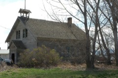 | Empire School | 3.1 miles | 2001 |
| National Archives record | The nomination case file for reference 10000074 in Record Group 79. |
| Minidoka County | All 5 listed properties in this county. |