 Block
From the record
One of 17 National Register listings published here for Bingham County · listed in 1979 · category: District.
Sources: the case file at the National Archives · the National Register database, National Park Service
Listed on the National Register of Historic Places in 1979.
One of 17 National Register listings published here for Bingham County · listed in 1979 · category: District.
Sources: the case file at the National Archives · the National Register database, National Park Service
Regional context, not property-specific evidence. The federal wildfire occurrence database lists 30 fires within 5 miles of North Shilling Historic District between 1993 and 2020, burning about 2,300 acres in total. 8 started naturally. None was recorded as arson. Distance is straight-line from the map coordinates, so a fire counted here may appear on a neighbouring settlement's page as well.
| Reported cause | Fires |
|---|---|
| Missing data/not specified/undetermined | 13 |
| Natural | 8 |
| Railroad operations and maintenance | 3 |
| Recreation and ceremony | 2 |
| Debris and open burning | 2 |
| Equipment and vehicle use | 1 |
| Power generation/transmission/distribution | 1 |
The most recent of them, most recent first, with the day each was reported and the service that recorded it.
| Date | Cause | Size | Reported by | Name on the report |
|---|---|---|---|---|
| 9 September 2005 | Natural | 1,994 acres | Idaho Falls District | DIVERSION |
| 9 September 2005 | Natural | 160 acres | Idaho Falls District | STEVENS PK |
| 7 September 2020 | Power generation/transmission/distribution | under an acre | Bingham County | BINGHAM COUNTY ASSIST 8 |
| 7 September 2019 | Missing data/not specified/undetermined | 3.0 acres | Fort Hall Agency | FORT HALL ASSIST 4 |
| 4 September 2008 | Railroad operations and maintenance | under an acre | Fort Hall Agency | FT HALL ASST 12 |
| 4 September 2008 | Railroad operations and maintenance | under an acre | Fort Hall Agency | FT HALL ASST 11 |
| 4 September 2008 | Railroad operations and maintenance | under an acre | Fort Hall Agency | FT HALL ASST 10 |
| 27 September 2018 | Missing data/not specified/undetermined | under an acre | Idaho Falls District | BINGHAM COUNTY ASSIST 10 |
Regional context, not property-specific evidence. The federal mineral resources record lists 8 workings within 5 miles of North Shilling Historic District: 4 past producers, 4 producers. 4 still produce. What was taken out: Sand and Gravel, Construction, Gold, Platinum, Titanium. Distance is straight-line from the map coordinates, so a quarry counted here may appear on a neighbouring settlement's page as well.
| Where | Site | Commodity | Status | Recorded |
|---|---|---|---|---|
| Welch Ground, and Gold Point and Eagle Bend | Gold, Platinum, Titanium | Producer | 1865 | |
| Snake River Placer | Gold | Past Producer | ||
| Blackfoot Pit and Plant | Sand and Gravel, Construction | Producer | ||
| Gravel Pit | Sand and Gravel, Construction | Past Producer | ||
| Gravel Pit | Sand and Gravel, Construction | Producer | ||
| Gravel Pit | Sand and Gravel, Construction | Past Producer | ||
| Gravel Pit | Sand and Gravel, Construction | Producer | ||
| Miller Pit | Sand and Gravel, Construction | Past Producer |
Regional context, not property-specific evidence. The National Weather Service names Blackfoot, the town this property stands in, in 61 storm reports between 1995 and 2025: 33 thunderstorm wind, 9 hail, 4 funnel cloud, 4 flood. The reports record 1 injury. Each account below is quoted exactly as the forecast office filed it, from the NOAA Storm Events Database, and each date opens the federal record of that event.
| When | Event | Place named | Harm | What the report says |
|---|---|---|---|---|
| April 1995 | Tornado (F0) | Blackfoot | 1 hurt, $500,000 | A series of tornados touch down in Bingham County causing damage to mobile homes, highway signs, and recreational equipment. |
| August 2014 | Flash Flood | Blackfoot | $300,000 | Nearly 2 inches of rain in less than an hour brought extensive flooding to the city of Blackfoot. Extensive street and parking lot flooding occurred with standing water on roadways a problem throughout the city. Several cars stalled out driving through water with one truck driving into an uncovered manhole Several manhole covers in roads became uncovered as the amount of water was too much for the cities drainage system. 30 homes and 15 businesses reported damage with house basements receiving the most damage. Several roads were also damaged. Damage in Blackfoot was estimated at $300,000. |
| March 2006 | Tornado (F0) | Blackfoot | $210,000 | F0 tornado touched down in the southeastern part of Blackfoot near Robertson Street and moved up University and Schilling Streets before lifting near the State Fairgrounds. Four trees downed at St Paul's Episcopal Church on Schilling Street. Windows at private residence on Schilling Street shattered and house severely damaged by felled tree. |
| March 2006 | Thunderstorm Wind | Blackfoot | $60,000 | no account filed |
| June 2013 | Lightning | Blackfoot | $20,000 | Lightning damage occurred in Blackfoot. One home on S Adams Ave had a window blown out with siding damage and damage to utility lines and appliances in the house. A telephone was knocked down near the courthouse. A trailer at the Sage Hill Travel Center was struck by lightning and destroyed. |
| March 2006 | Thunderstorm Wind | Blackfoot | $10,000 | no account filed |
| September 1997 | Thunderstorm Wind | Blackfoot | $10,000 | no account filed |
| August 2023 | Thunderstorm Wind | Blackfoot | $5,000 | Numerous sections of trees and large tree limbs blown down just west of interstate 15 across the Collins, Aiken, Clarkson, Riverside and Groveland communities. |
| June 2011 | Flood | Blackfoot | $5,000 | The Snake River at Blackfoot was above flood stage from June 1st through June 19th. It was below flood stage from June 13th through June 16th. Water levels reached moderate flood stage and crested at 11.79 feet on the evening of June 10th. There was widespread floodign in the Riverton area resulting in the closure of Riverton Road with several homes threatened. A number of homes and access roads were threatened in the Thomas area near Riverbend Road and Wilson Road. Berm construction and sandbagging appeared to have been successful in those areas. Archery Range Road near the Rose Overpass was submerged and impassable for a period. In Blackfoot, sub-water seepage into Jensens Grove caused minor flooding of the park. Flooding of lowland and agricultural fields occurred adjacent to the river between Rose and Tilden Bridge. |
| July 2024 | Thunderstorm Wind | Blackfoot | $3,000 | Large tree downed on wood stockade fence knocking it down. Occurred along Pendlebury Lane. Power outage also reported. |
| August 2024 | Thunderstorm Wind | Blackfoot | $3,000 | Three large trees reported downed at Jensen Grove Park in Blackfoot. |
| August 2013 | Thunderstorm Wind | Blackfoot | $3,000 | Strong thunderstorm outflow winds on August 12th downed 3 trees at a Blackfoot home. It did damage to the roof and some storage sheds. |
| August 2023 | Thunderstorm Wind | Blackfoot | $2,200 | Two large pine trees and part of a willow tree downed on Colonial Loop just off of US Highway 26 in Blackfoot. |
| July 2024 | Thunderstorm Wind | Blackfoot | $2,000 | Large tree uprooted and down on a truck near the intersection of Dennis St and Opal Str. |
| July 2024 | Thunderstorm Wind | Blackfoot | $2,000 | Two trees downed on River Ranch Rd. |
| May 2011 | Flood | Blackfoot | $2,000 | The Snake River at Blackfoot reached flood stage of 10 feet on May 10th and remained over flood stage the remainder of the month peaking at 12.04 feet on May 29th. The Riverton area had widespread flooding resulting in the closure of Riverton Road with several homes threatened. The Rose Levee broke on May 27th resulting in the washout of about 200 feet of levee structure. Flows occurred through the Rose Ponds recreation area flooding campgrounds and a walking path. The Archery Range Road was flooded causing the evacuation of a resident from their property. In Blackfoot, sub-water seepage into Jensen's Grove caused minor flooding of the park and an industrial storage lot behind the Super 8 Motel and Blackfoot Medical Center. Flooding of lowlands and agricultural fields occurred adjacent to the river between Rost and Tilden Bridge. The Snake River at Shelley reached flood stage on May 16th at 12 feet and peaked at 13.15 feet on May 28th which was major flood stage. County Road 700 North southwest of Firth was closed. In firth, the Riverview Arena was partially underwater and extensive flooding of lowlands and agricultural fields occurred adjacent to the river between Firth and Rose. |
| July 2010 | Thunderstorm Wind | Blackfoot | $2,000 | Trees downed in the City of Blackfoot reported by law enforcement officers. |
| July 2024 | Thunderstorm Wind | Blackfoot | $1,000 | Large pine tree uprooted on corner of W Center St and Lansing St. |
| July 2024 | Thunderstorm Wind | Blackfoot | $1,000 | Large tree downed at Blackfoot High School. |
| August 2024 | Thunderstorm Wind | Blackfoot | $1,000 | Several reports of localized tree damage in Blackfoot. |
| August 2023 | Thunderstorm Wind | Blackfoot | $1,000 | Large cottonwood tree blown over with numerous small branches down as well. |
| May 2017 | Thunderstorm Wind | Blackfoot | $1,000 | Roofing material was blown onto Main Street in Blackfoot when a microbust struck a warehouse building owned by Blacker's Furniture Store. It tied up traffic for a very short time. |
| August 2007 | Thunderstorm Wind | Blackfoot | $1,000 | Thunderstorm winds knocked down basketball hoop, broke window in mini-van and tore shingles off roof. |
| September 1997 | Lightning | Blackfoot | $1,000 | Lightning ignited a Tanner Lane straw stack with the resultant fire destroying about 2000 bales. |
| June 2009 | Hail | Blackfoot | $300 | Broke car wind shield. |
| July 2024 | Thunderstorm Wind | Blackfoot | $250 | Window at a residence broken by flying tree limb. |
| May 2025 | Hail | Blackfoot | - | Hail of 1.25 inches fell 14 miles northwest of Chesterfield. |
| July 2024 | Thunderstorm Wind | Blackfoot | - | Idaho Power reported approximately 7,700 customers without power from Gibson to Blackfoot to Wapello. |
| May 2022 | Thunderstorm Wind | Blackfoot | - | Mesonet site BLK 1 mile east southeast of Blackfoot recorded a 61 mph wind gust. |
| June 2019 | Funnel Cloud | Blackfoot | - | Funnel cloud photograph taken by public. |
| June 2019 | Funnel Cloud | Blackfoot | - | A funnel cloud was observed on Porterville Road just north of Blackfoot. |
| October 2016 | Thunderstorm Wind | Blackfoot | - | A 72 mph wind gust measured 30 miles northwest of Blackfoot. |
| April 2016 | Funnel Cloud | Blackfoot | - | Photographs were taken of a funnel cloud near Blackfoot on April 29th. |
| June 2015 | Hail | Blackfoot | - | One inch hail fell in Blackfoot. |
| July 2015 | Hail | Blackfoot | - | One inch hail reported in Blackfoot. |
| July 2010 | Thunderstorm Wind | Blackfoot | - | Sixty mph wind gusts reported by trained spotter 3 miles east northeast of Blackfoot. |
| June 2009 | Flood | Blackfoot | - | Extensive street flooding from heavy rains in Blackfoot residential areas. |
| June 2009 | Thunderstorm Wind | Blackfoot | - | A 74 mile per hour wind gust reported in Blackfoot. |
| June 1998 | Thunderstorm Wind | Blackfoot | - | Trees blown down. |
| July 1998 | Thunderstorm Wind | Blackfoot | - | Trees blown down. |
| July 1998 | Lightning | Blackfoot | - | Ignited brush fire that burned 23,360 acres. |
| July 1997 | Flood | Blackfoot | - | Heavy rains flooded a few streets in Blackfoot. Some residents in low lying areas reported water in homes. |
| September 1997 | Thunderstorm Wind | Blackfoot | - | Nearly 700 Idaho Power Co. customers were without electricity for nearly two hours because three cottonwood trees were blown across Groveland Road by an intense thunderstorm. |
| June 2009 | Hail | Blackfoot | - | no account filed |
| March 2006 | Thunderstorm Wind | Blackfoot | - | no account filed |
| July 2006 | Hail | Blackfoot | - | no account filed |
| July 2006 | Flash Flood | Blackfoot | - | no account filed |
| May 2005 | Hail | Blackfoot | - | no account filed |
| August 2004 | Thunderstorm Wind | Blackfoot | - | no account filed |
| August 2004 | Thunderstorm Wind | Blackfoot | - | no account filed |
| August 2003 | Thunderstorm Wind | Blackfoot | - | no account filed |
| August 2003 | Flash Flood | Blackfoot | - | no account filed |
| August 2003 | Wildfire | Blackfoot | - | no account filed |
| April 2002 | Thunderstorm Wind | Blackfoot | - | no account filed |
| August 2001 | Wildfire | Blackfoot | - | no account filed |
| September 2001 | Thunderstorm Wind | Blackfoot | - | no account filed |
| August 2000 | Wildfire | Blackfoot | - | no account filed |
| January 1998 | Thunderstorm Wind | Blackfoot | - | no account filed |
| August 1997 | Hail | Blackfoot | - | no account filed |
| July 1996 | Funnel Cloud | Blackfoot | - | no account filed |
No historic map-sheet match is published for this property yet. That does not mean no map exists. This record needs a coordinate-quality review before it can be joined to a sheet boundary. Browse the county's mapped places while that work is pending.
Other National Register properties close enough to walk or drive between, ordered by distance from this one. Both positions come from the same geocoding pass that matched these properties to their map sheets.
| Photograph | Property | Distance | Listed |
|---|---|---|---|
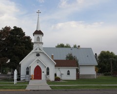 | St. Paul's Episcopal Church | under 500 feet | 1979 |
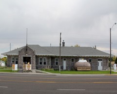 | Blackfoot Railway Depot | 0.1 miles | 1974 |
 | Shilling Avenue Historic District | 0.1 miles | 1983 |
| J. W. Jones Building | 0.2 miles | 1982 | |
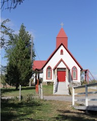 | Ross Fork Episcopal Church | 0.2 miles | 1983 |
 | Blackfoot LDS Tabernacle | 0.2 miles | 1977 |
| National Archives record | The nomination case file for reference 79000777 in Record Group 79. |
| Bingham County | All 17 listed properties in this county. |