
BlockBefore
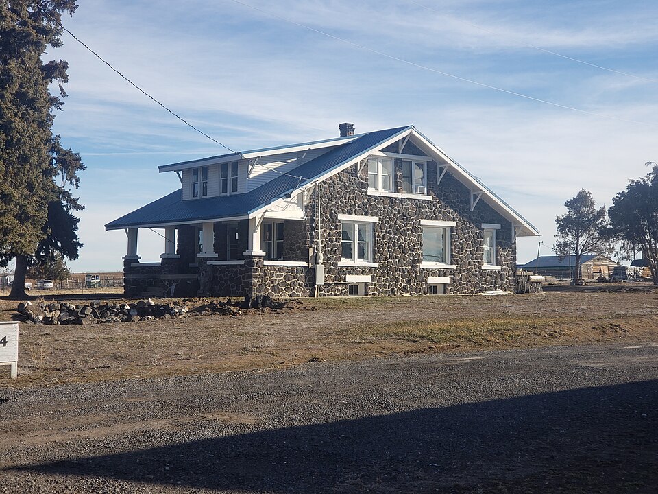
Photograph of William Weigle House and Water Tank
Photograph by 25or6to4, CC BY-SA 4.0. Via Wikimedia Commons.

William Weigle House and Water Tank

Built in 1919 (bungalow). Listed on the National Register of Historic Places in 1983.

From the record

“The William Weigle House and Water Tank, near Jerome, Idaho, is a lava rock structure built in 1919. It was listed on the National Register of Historic Places in 1983.”

Wikipedia article William Weigle House and Water Tank, CC BY-SA 4.0.

One of 64 National Register listings published here for Jerome County · listed in 1983 · category: Building · built in 1919, bungalow.

Sources: the Wikipedia article · the case file at the National Archives · the National Register database, National Park Service
The listing

  • What is counted as historic. The nomination lists 2 buildingss as contributing to the listing.
  • Listed as. Weigle, William, House and Water Tank - the National Register files a house under its owner's surname.
  • Address. NW of Jerome, Jerome, 83338
  • When was it listed? September 1983
  • Category. building
  • Also known as. Lava Rock Structures in South Central Idaho TR
  • Census division. Jerome
  • When was it built? 1919
  • Architectural style. bungalow
  • National Register reference number. 83002315 - the number the National Park Service assigned this property when it was listed, and the key its nomination file is catalogued under at the National Archives.

Fires near this property

9 since 1998

Regional context, not property-specific evidence. The federal wildfire occurrence database lists 9 fires within 5 miles of William Weigle House and Water Tank between 1998 and 2020, burning about 2,418 acres in total. 4 started naturally. None was recorded as arson. Distance is straight-line from the map coordinates, so a fire counted here may appear on a neighbouring settlement's page as well.

Reported cause Fires
Natural4
Missing data/not specified/undetermined3
Debris and open burning2

The most recent of them, most recent first, with the day each was reported and the service that recorded it.

DateCause SizeReported by Name on the report
7 September 1998Missing data/not specified/undetermined88 acresTwin Falls DistrictWENDELLIST
25 August 2020Natural1,556 acresEastern Supervisory Area OfficeCOUNTY LINE
13 August 2003Debris and open burningunder an acreTwin Falls DistrictESCAPE
9 July 2005Natural57 acresTwin Falls District700 ROAD
2 July 2011Missing data/not specified/undetermined8.0 acresTwin Falls DistrictWEST CANAL
11 July 2006Natural706 acresTwin Falls DistrictCANAL
1 July 2005Debris and open burning1.0 acresTwin Falls DistrictI84 MM162
17 June 2015Missing data/not specified/undetermined1.1 acresTwin Falls District400 WEST

Every fire recorded in Jerome County

Mines and quarries near this property

1 within 5 miles

Regional context, not property-specific evidence. The federal mineral resources record lists 1 working within 5 miles of William Weigle House and Water Tank: 1 producer. All of them still produce. What was taken out: Sand and Gravel, Construction. Distance is straight-line from the map coordinates, so a quarry counted here may appear on a neighbouring settlement's page as well.

Where SiteCommodity StatusRecorded
Wendell Screening PlantSand and Gravel, ConstructionProducer

Every working recorded in Jerome County

Storms near this property

17 since 1997

Regional context, not property-specific evidence. The National Weather Service names Jerome, the town this property stands in, in 17 storm reports between 1997 and 2025: 9 thunderstorm wind, 5 hail, 2 flood, 1 tornado. No death or injury is recorded in these reports. Each account below is quoted exactly as the forecast office filed it, from the NOAA Storm Events Database, and each date opens the federal record of that event.

WhenEvent Place namedHarm What the report says
February 2017FloodJerome$2,750,000Rainfall and rapid melting of low elevation snowpack on top of frozen and saturated soil led to widespread flooding. Many roads around Jerome were damaged and closed due to flood waters. Widespread flooding of agricultural lands occurred.
May 2025Thunderstorm WindJerome-A tree branch with a width estimated to be 1.5 - 2 feet in diameter fell onto a parked car, causing significant damage to a parked car. Winds are estimated to be 65 MPH, given the size of the branch that fell while also taking into consideration that the branch appeared to be unhealthy in the image.
June 2017Thunderstorm WindJerome-The local newspaper reported that a barn had collapsed and power poles were down just north of Jerome.
July 2017Thunderstorm WindJerome-The Jerome Butte ITD station reported a wind gust of 64 MPH.
July 2014Thunderstorm WindJerome-One tree blown down and tin roofing removed from the roof of a barn in Jerome. Images forwarded by KMVT.
August 2014HailJerome-A trained spotter reported ping pong ball size hail covering most of the ground and damage to his corn crop.
July 2013Thunderstorm WindJerome-A wind gust of 60 MPH was reported at the Jerome ASOS.
May 2013Tornado (EF0)Jerome-A Jerome County deputy reported a brief tornado touchdown. No damage was reported.
August 2013HailJerome-Local media reported quarter sized hail around the Jerome, Idaho area.
August 2012Thunderstorm WindJerome-KMVT television station reported a large tree was uprooted in Jerome, Idaho.
January 2011FloodJerome-The North Side Canal overflowed around the intersection of Tiger Drive and 16th Avenue East on Monday the 17th. City workers cleared mud and debris from streets and some homes and basements were flooded.
August 2010Thunderstorm WindJerome-Jerome County Sherrif dispatch reported trees and power lines down in the town of Jerome and the ASOS reported a wind gust of 67 MPH.
August 2003Thunderstorm WindJerome-Wide spread thunderstorms moved into in Jerome County. These storms brought, heavy rain and strong winds that blew down trees and caused power outages in Jerome and Gooding counties. Blowing dust across Interstate 84 with visibilities as low as 10 feet caused several accidents.
May 1998HailJerome-The Jerome County Sheriff reported 1.75 inch hailstones from a severe thunderstorm.
August 1997HailJerome-A spotter in Jerome reported 7/8 inch hail with an evening thunderstorm.
August 2000Thunderstorm WindJerome-no account filed
June 1998HailJerome-no account filed

Every storm recorded in Jerome County

Map coverage status

No historic map-sheet match is published for this property yet. That does not mean no map exists. This record needs a coordinate-quality review before it can be joined to a sheet boundary. Browse the county's mapped places while that work is pending.

Listed places nearby

6 within 8 miles

Other National Register properties close enough to walk or drive between, ordered by distance from this one. Both positions come from the same geocoding pass that matched these properties to their map sheets.

Photograph PropertyDistance Listed
Carl Blessing Outbuildings0.6 miles1983
G. H. Erdman House2.4 miles1983
Arnold Stevens House2.4 miles1983
Jessie Osborne House2.4 miles1983
W. H. Silbaugh House2.5 miles1983
Lulu Graves Farm3.0 miles1983

Sources for this property

National Archives recordThe nomination case file for reference 83002315 in Record Group 79.
Wikipedia articleCommunity-written account of this property, licensed CC BY-SA.
Jerome CountyAll 64 listed properties in this county.

Provenance

  • Listing record. National Park Service National Register of Historic Places, listed-properties dataset, current to 2026-05-22.
  • Map join. Address geocoded through the United States Census geocoder, then tested against the published boundary of every sheet in the USGS Historical Topographic Map Collection.
  • How this page is made. Listing fields come from federal records; map-sheet coverage is a labelled coordinate-to-boundary calculation, not a source-field claim.
  • Wildfire. Short, Karen C. 2022. Spatial wildfire occurrence data for the United States, 1992-2020 [FPA_FOD_20221014]. 6th Edition. Fort Collins, CO: Forest Service Research Data Archive. https://doi.org/10.2737/RDS-2013-0009.6 Collected with United States Government funding and usable without additional permissions or fees.
  • Mines and quarries. USGS Mineral Resources Data System (MRDS) https://mrdata.usgs.gov/mrds/ A work of the United States government, no copyright under 17 U.S.C. 105.
  • Storms. NOAA National Centers for Environmental Information, Storm Events Database https://www.ncei.noaa.gov/stormevents/ A work of the United States government, no copyright under 17 U.S.C. 105. Narratives are quoted verbatim from the National Weather Service report and are not edited or summarised.