 Block
From the record
4 National Register listings published here.
Sources: the county history on the Internet Archive · the National Register database, National Park Service
54 topographic sheets cover 24 settlements here, and 4 properties are on the National Register of Historic Places.
4 National Register listings published here.
Sources: the county history on the Internet Archive · the National Register database, National Park Service
Every property in this county listed on the National Register of Historic Places, with the year it was listed and the federal nomination document.
| Photograph | Property | Type | Listed | Reference |
|---|---|---|---|---|
 | Lock and Dam No. 18 Historic District | district | 2004 | 04000178 |
 | Oquawka Wagon Bridge | structure | 1975 | 75000660 |
 | Alexis Phelps House | building | 1982 | 82002537 |
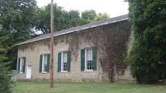 | South Henderson Church and Cemetery | building | 1976 | 76000709 |
The NOAA Storm Events Database holds 223 reports for this county, causing no deaths, 1 injury and about $20,505,340 in recorded property damage. Each settlement page carries the reports that name it.
| Kind of event | Reports |
|---|---|
| Thunderstorm Wind | 86 |
| Hail | 66 |
| Flood | 34 |
| Flash Flood | 19 |
| Tornado | 13 |
| Funnel Cloud | 3 |
| Heavy Rain | 2 |
The most serious of them, by death, then injury, then recorded damage. The accounts are quoted exactly as the forecast office filed them.
| When | Event | Place named | Harm | What the report says |
|---|---|---|---|---|
| July 2003 | Thunderstorm Wind | Gulfport | 1 hurt, $200,000 | Trees down & semi overturned |
| May 2003 | Hail | Gladstone | $10,000,000 | no account filed |
| April 1996 | Tornado (F1) | Bald Bluff | $4,000,000 | no account filed |
| April 1996 | Tornado (F0) | Oquawka | $4,000,000 | no account filed |
| May 2003 | Flash Flood | Countywide | $500,000 | IL 94 and other roads covered with water |
| April 2013 | Flood | Big River St Forest | $250,000 | Several rounds of heavy rains fell across much of Henderson County from the afternoon of April 17 through the morning of April 18. |
| June 2010 | Flood | Gulfport | $250,000 | Heavy rains during the third week of June resulted in the Mississippi River at Burlington going above the moderate flood stage level of 16.5 feet on June 22 around 230 pm. It crested around 16.95 feet around 1 pm June 26. It fell below the moderate flood stage level around 4 am June 28. |
| April 2011 | Flood | Lomax | $250,000 | no account filed |
| May 2003 | Hail | Gladstone | $250,000 | no account filed |
| April 1984 | Tornado (F0) | not stated | $250,000 | no account filed |
| July 2010 | Flood | Big River St Forest | $125,000 | no account filed |
| July 2003 | Thunderstorm Wind | Countywide | $100,000 | Trees & wires down southern half of county |
| April 2010 | Thunderstorm Wind | Raritan | $50,000 | Wind gusts estimated to be 60 mph blew a machine shed over and damaged several small outbuildings near Raritan, IL around 630 pm April 4. |
| May 1993 | Tornado (F1) | Stronghurst | $50,000 | Two grain bins were destroyed and a barn roof was blown off southeast of Stronghurst. A machine tool shed was also destroyed. Some trees were blown down and two cars were rolled over. |
| May 2003 | Hail | Carman | $50,000 | no account filed |
| July 2015 | Tornado (EF1) | Lone Tree | $25,000 | An EF1 tornado with maximum winds estimated at 95 mph touched down 1.1 miles east of Lone Tree, IL. The tornado traveled 0.84 miles and lifted 1.8 miles east northeast of Lone Tree. The maximum path width was about 100 yards. Along the path, trees and outbuildings were destroyed. |
| June 2011 | Thunderstorm Wind | Terre Haute | $25,000 | Wind gusts estimated to be 70 mph caused some tree damage in the Terre Haute Cemetery just north of Terre Haute, IL and blew a tree down onto a house in Terre Haute, IL around 150 am CDT June 27. |
| August 2007 | Thunderstorm Wind | Biggsville | $25,000 | Winds estimated to be 70 mph blew down several trees in Biggsville, IL. A house and car were damaged. Delayed report. Time of report corrected from previous issuance indicating 1:25 AM. |
| January 1967 | Tornado (F2) | not stated | $25,000 | no account filed |
| June 2008 | Thunderstorm Wind | Oquawka | $15,000 | Winds estimated to be 65 mph blew down some power lines in Oquawka, IL at 8:50 pm June 8. |
| June 1998 | Tornado (F1) | Bald Bluff | $15,000 | no account filed |
| August 2007 | Thunderstorm Wind | Biggsville | $10,000 | Winds estimated to be 70 mph blew down several trees just south of Biggsville, IL. Several trees were blocking highways 94 and 96 as well as some township roads. Delayed report. |
| June 2005 | Thunderstorm Wind | Countywide | $10,000 | Bow echo crossed the Mississippi and affected mainly the northern half of the county. The squall line had weakened and since the county was immediately south of the bow apex, damage was extremely sporatic but consisted of several trees down along with power lines down. A building and irrigation system were damaged 3N of Bald Bluff by trees and a house was damaged in Stronghurst when a 24 inch diameter tree fell on it. Based on radar, the following times have been established (all CST); 3N of Bald Bluff 1205-1214, Stronghurst 1214-1217. |
| June 2010 | Thunderstorm Wind | Oquawka | $5,000 | Wind gusts knocked down power poles, leaving residents of Biggsville without opwer for about 24 hours. |
| July 2008 | Thunderstorm Wind | Lomax | $5,000 | Wind gusts estimated to be over 60 mph blew some trees and power lines down in the Dallas City, IL area around 756 pm July 27. One tree was blocking Route 96 on the northeast side of town in Henderson County. |
| April 2006 | Hail | Oquawka | $5,000 | Also reported by a spotter; nickel to quarter size hail covering the ground. |
| August 2004 | Thunderstorm Wind | Gladstone | $4,000 | Trees down west of Gladstone to south of Gladstone |
| April 2006 | Hail | Carman | $3,000 | Emergency manager also reported estimated 43 knot (50 mph) winds. |
| August 2005 | Thunderstorm Wind | Big River St Forest | $2,000 | WFO DVN Electronics Technician reported some trees were downed along with several large branches on County Route 3 just north of Bald Bluff Road. |
| August 2004 | Hail | Biggsville | $2,000 | Jct of IL 164 and 94 |
| August 2004 | Thunderstorm Wind | Stronghurst | $2,000 | no account filed |
| April 2000 | Thunderstorm Wind | Biggsville | $1,000 | Thunderstorm winds downed several trees along Illinois Route 94 between Biggsville and Rozetta. |
| August 2004 | Hail | Stronghurst | $1,000 | no account filed |
| April 2009 | Flood | Bald Bluff | $250 | Heavy rains of 2 to 3 inches fell over portions of northeast Henderson County during the morning of April 30 resulting in flooding of creeks, streams, and low-lying areas as well as some basements of area residences. |
| April 1984 | Tornado (F0) | not stated | $30 | no account filed |
| April 1984 | Tornado (F0) | not stated | $30 | no account filed |
| April 1984 | Tornado (F0) | not stated | $30 | no account filed |
| March 2025 | Thunderstorm Wind | Bald Bluff | - | Recorded gust with wind measuring equipment. |
| August 2025 | Thunderstorm Wind | Stronghurst | - | Downed tree and branches reported. |
| June 2025 | Thunderstorm Wind | Lone Tree | - | Trained spotter measured wind gust. |
| March 2024 | Thunderstorm Wind | Biggsville | - | Thunderstorm wind damage to a grain bin. |
| July 2024 | Thunderstorm Wind | Biggsville | - | A trained spotter reported a power pole down on Highway 94. |
| July 2024 | Flood | Gladstone | - | The Mississippi River at Gladstone rose above its major flood stage of 14 feet around 5 PM on July 2nd and crested at 16.32 feet on July 12th. The river fell back below major flood stage around 7 PM on July 22nd. |
| August 2024 | Thunderstorm Wind | Biggsville | - | Downed fencing reported with estimated 60 MPH wind gusts. |
| August 2024 | Thunderstorm Wind | Raritan | - | A relayed report of some damage to a building on Main Street. Also reported several tree limbs down in town. |
| March 2023 | Thunderstorm Wind | Rozetta | - | Pea sized hail was also falling at the time of the severe wind gust. |
| April 2023 | Flood | Heapsville | - | The Mississippi River at Burlington rose above its major flood stage of 18.0 feet during the evening hours of April 26th. The river continues to rise to 19.68 feet on the evening of April 30th. |
| April 2023 | Flood | Gladstone | - | The Mississippi River at Gladstone rose above its major flood stage of 14 feet during the early morning hours of April 27th. It continued to rise to 15.6 feet during the evening hours of April 30th. |
| June 2023 | Hail | Terre Haute | - | Three farmers in this area reported quarter size hail, which resulted in crop damage. The time of this report was estimated from radar. |
| August 2023 | Flash Flood | Lomax | - | Law Enforcement reported that IL-96 was flooded in a construction zone around Camp Creek. The flooding was discovered around 615 AM CDT. |
| July 2022 | Thunderstorm Wind | Lomax | - | A public report of a large tree down via social media. the The time of the event was estimated using radar. |
| April 2021 | Thunderstorm Wind | Stronghurst | - | A spotter reported a snapped tree and a power line down on social media. |
| April 2020 | Flood | Carthage Lake | - | The Mississippi River at Burlington Iowa (BRLI4) rose above its major flood stage of 18 feet at 9 PM CST on April 11th and fell back below major flood stage at 1 AM on April 16th. The river crested 18.21 feet at 6 AM on April 13th. |
| September 2020 | Hail | Oquawka | - | A CoCoRaHS observer reported quarter size hail. |
| July 2020 | Thunderstorm Wind | Rozetta | - | A home weather station recorded an 84 mph wind gust. |
| November 2020 | Thunderstorm Wind | Gladstone | - | Estimated 60 mph winds with extremely heavy rain, leading to loss of power. |
| July 2020 | Thunderstorm Wind | Oquawka | - | Trees and power lines were blown down. |
| July 2020 | Thunderstorm Wind | Rozetta | - | A spotter reported trees and power lines blown down, along with three sheets of metal peeled off a hog building roof. |
| July 2020 | Thunderstorm Wind | Big River St Forest | - | Trees blown down across a road, trapping a car on the road. No injuries occurred. |
| March 2019 | Flood | Oquawka | - | Heavy rain and snow melt across the region caused the Mississippi River at Lock and Dam 18 near Gladestone to to rise above major flood stage of 14 feet on March 17th. The Mississippi River at Burlington Iowa rose above major flood stage on the same day and remained there through the end of the month. The river remained above the major flood stage through the end of the month. An initial crest of 16.31 feet occurred early in the morning on the 24th, into the early morning hours of the 26th. |
The Survey's mineral resources record lists 9 workings inside this county. 3 still produce and 6 are closed or unrecorded. Each settlement page carries the workings within five miles of it.
| Commodity | Workings |
|---|---|
| Stone, Crushed/Broken | 7 |
| Sand and Gravel, Construction | 1 |
| Granite | 1 |
The least common of them first, because a county's hundredth gravel pit says nothing its first ten did not.
| Where | Site | Commodity | Status | Recorded |
|---|---|---|---|---|
| Addleman Sand Pit | Sand and Gravel, Construction | Producer | ||
| Monmouth Stone Company Quarry | Granite | Past Producer | ||
| Biggsville Quarry Cessford Const. | Stone, Crushed/Broken | Producer | ||
| Biggsville Quarry Medusa Agg. | Stone, Crushed/Broken | Past Producer | ||
| Dallas City Quarry | Stone, Crushed/Broken | Producer | ||
| Dallas City Quarry Turner Stone | Stone, Crushed/Broken | Past Producer | ||
| Dollar Quarry | Stone, Crushed/Broken | Past Producer | ||
| Limestone Prospect | Stone, Crushed/Broken | Occurrence | ||
| Media Quarry | Stone, Crushed/Broken | Past Producer |
One book written about this county, cut here where the book itself is cut, at its printed chapters: 1 chapter in all. Every chapter is public domain, machine-read from the scan and reproduced complete. A chapter already given under one of the county's towns is not repeated in this list.
| Chapter | Length |
|---|---|
| The whole text | 363,687 words in 23 parts |
Named settlements recorded in the Geographic Names Information System, each with the topographic sheets covering it. Villages, hamlets and abandoned places alike. Each is shown with the nearest named watercourse or landform and the survey quadrangle it falls on.
Biggsville township · 61418 · On Old Tom Creek · Kirkwood West quadrangle
17 sheets, 1934 to 1990
Carman township · 61425 · Near Harper Island · Burlington quadrangle
18 sheets, 1934 to 1990
Gladstone township · 61437 · On South Henderson Creek · Gladstone quadrangle
17 sheets, 1934 to 1990
Carman township · 61425 · On Ellison Creek · Burlington quadrangle
18 sheets, 1934 to 1990
Lomax township · 61454 · On Little Dugout Creek · Lomax quadrangle
14 sheets, 1932 to 1990
Carman township · 61425 · On Ellison Creek · Burlington quadrangle
18 sheets, 1934 to 1990
No longer a settlement
The vanished settlements of Henderson County: the places named above that are no longer on the map.