Listed on the National Register of Historic Places in 1976.
From the record
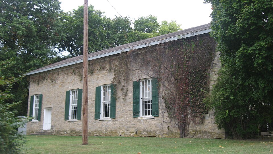
“The South Henderson Church is a historic Presbyterian church located in rural Henderson County, Illinois, north of the village of Biggsville. The church was built in 1854; it was the second church building used by the local Associate Reformed Presbyterian congregation, which formed in 1835 and built its first church two years later.”
Wikipedia article South Henderson Church, CC BY-SA 4.0.
One of 4 National Register listings published here for Henderson County · listed in 1976 · category: Building.
National Register reference number.76000709- the number the National Park Service assigned this property when it was listed, and the key its nomination file is catalogued under at the National Archives.
Mines and
quarries near this property
3 within 5 miles
Regional context, not property-specific
evidence. The federal mineral resources record lists
3 workings within 5 miles of South Henderson Church and Cemetery: 1 past producer, 1 producer, 1 occurrence.
1 still produces. What was taken out: Stone, Crushed/Broken, Granite. Distance is straight-line from the
map coordinates, so a quarry counted here may appear on a neighbouring
settlement's page as well.
Regional context, not property-specific
evidence. The National Weather Service names
Gladstone, the town this property stands in, in 15 storm reports between 1996 and 2024: 5 hail, 5 flood, 4 thunderstorm wind, 1 flash flood.
No death or injury is recorded in these reports. Each account below is quoted exactly as the forecast office
filed it, from the NOAA Storm Events Database, and each date
opens the federal record of that event.
The Mississippi River at Gladstone rose above its major flood stage of 14 feet around 5 PM on July 2nd and crested at 16.32 feet on July 12th. The river fell back below major flood stage around 7 PM on July 22nd.
The Mississippi River at Gladstone rose above its major flood stage of 14 feet during the early morning hours of April 27th. It continued to rise to 15.6 feet during the evening hours of April 30th.
The Mississippi River at Burlington (BRLI4) began the month above its major flood stage of 18 feet and continued to see major flooding through the end of the month, with only one short period on the 17th, where it dipped back down to near 18 feet. The river stage at the beginning of the month was 20.4 feet. The river would rise to a crest of 23.54 feet on May 3rd. This crest is preliminary the 4th highest crest. The river rose to a even higher crest in early June.
Episodes of heavy rainfall of about 5 to 15 inches in a 10 day period in much of northeast Iowa and southwest Wisconsin caused the Mississippi River to rise above major flood stage at Gladstone. The extended duration between the forecast and actual lower end major river flooding allowed preparations to preclude major damage downstream. Gladstone rose above major flood stage of 14.0 feet at 245 PM CST on 9 September. Then crested around 14.23 feet at 930 PM CST on September 11th and fell below 14.0 feet at approximately 130 AM CST on 13 September.
The river rose above flood stage at Gladstone LD18 on October 2 at 800 pm cst and fell below flood stage on October 16 at 430 am cst. Moderate flooding occurred with the crest reaching 12.33 feet on October 8 at 500 am cst. Flood stage is 10 feet.
No historic map-sheet match is published
for this property yet. That does not mean no map exists. This record needs
a coordinate-quality review before it can be joined to a sheet boundary.
Browse the county's mapped places while that work is
pending.
Listed places nearby
3 within 8 miles
Other National Register properties close
enough to walk or drive between, ordered by distance from this one. Both
positions come from the same geocoding pass that matched these properties
to their map sheets.
Listing record. National Park Service National Register of Historic Places, listed-properties dataset, current to 2026-05-22.
Map join. Address geocoded through the United States Census geocoder, then tested against the published boundary of every sheet in the USGS Historical Topographic Map Collection.
How this page is made. Listing fields come from federal records; map-sheet coverage is a labelled coordinate-to-boundary calculation, not a source-field claim.
Mines and quarries. USGS Mineral Resources Data System (MRDS) https://mrdata.usgs.gov/mrds/ A work of the United States government, no copyright under 17 U.S.C. 105.
Storms. NOAA National Centers for Environmental Information, Storm Events Database https://www.ncei.noaa.gov/stormevents/ A work of the United States government, no copyright under 17 U.S.C. 105. Narratives are quoted verbatim from the National Weather Service report and are not edited or summarised.
 Block