 Block
From the record
1 National Register listing published here.
Sources: the National Register database, National Park Service
85 topographic sheets cover 36 settlements here, and 1 property is on the National Register of Historic Places.
1 National Register listing published here.
Sources: the National Register database, National Park Service
Every property in this county listed on the National Register of Historic Places, with the year it was listed and the federal nomination document.
| Photograph | Property | Type | Listed | Reference |
|---|---|---|---|---|
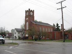 | Golconda Historic District | district | 1976 | 76000726 |
Every wildfire the federal occurrence database records inside this county: 171 of them, burning about 1,615 acres. 3 started naturally and 29 were recorded as arson. Each settlement page carries the fires within five miles of it.
| Reported cause | Fires |
|---|---|
| Debris and open burning | 52 |
| Missing data/not specified/undetermined | 36 |
| Recreation and ceremony | 30 |
| Arson/incendiarism | 29 |
| Equipment and vehicle use | 8 |
| Smoking | 6 |
| Natural | 3 |
| Power generation/transmission/distribution | 3 |
| Railroad operations and maintenance | 3 |
| Misuse of fire by a minor | 1 |
The five largest, by the area the report gives. Five of them were set deliberately.
| Date | Cause | Size | Reported by | Name on the report |
|---|---|---|---|---|
| 27 February 2006 | Arson/incendiarism | 129 acres | Shawnee National Forest | ASHBY |
| 28 February 2004 | Arson/incendiarism | 100 acres | Shawnee National Forest | ASHBY |
| 19 February 2004 | Debris and open burning | 80 acres | Shawnee National Forest | OLD BARN |
| 14 April 1992 | Misuse of fire by a minor | 80 acres | Shawnee National Forest | not named |
| 19 June 2009 | Arson/incendiarism | 70 acres | Shawnee National Forest | POPE COUNTY |
| 27 February 2006 | Arson/incendiarism | 60 acres | Shawnee National Forest | WALTERSBURG |
| 4 November 2005 | Recreation and ceremony | 59 acres | Shawnee National Forest | GLEN STREET ROAD |
| 19 March 1995 | Arson/incendiarism | 55 acres | Shawnee National Forest | BARGER |
Every settlement page carries the fires within five miles of it - see the settlement index below.
The NOAA Storm Events Database holds 173 reports for this county, causing 3 deaths, 6 injuries and about $7,027,500 in recorded property damage. Each settlement page carries the reports that name it.
| Kind of event | Reports |
|---|---|
| Thunderstorm Wind | 56 |
| Flood | 40 |
| Hail | 34 |
| Flash Flood | 18 |
| Tornado | 14 |
| Heavy Rain | 7 |
| Funnel Cloud | 4 |
The most serious of them, by death, then injury, then recorded damage. The accounts are quoted exactly as the forecast office filed them.
| When | Event | Place named | Harm | What the report says |
|---|---|---|---|---|
| April 1972 | Tornado (F3) | not stated | 3 killed, $25,000 | no account filed |
| April 1972 | Tornado (F1) | not stated | 2 hurt, $250,000 | no account filed |
| March 1997 | Flash Flood | Eddyville | 2 hurt, $50,000 | no account filed |
| April 2002 | Tornado (F3) | Dixon Spgs | 1 hurt, $400,000 | The tornado touched down near Dixon Springs and tracked east, parallel and very close to Illinois Route 146. The path was through rural farm country and the Shawnee National Forest. A couple of farm buildings were damaged near the beginning of the track. Where the tornado crossed Route 146, a mobile home was destroyed, injuring one person. On the north side of Golconda, one brick home was destroyed and a couple of nearby homes were damaged. The tornado then crossed the Ohio River into Kentucky. |
| July 2016 | Flash Flood | Bristol | 1 hurt, $1,000 | Flash flooding of a creek in the Shawnee National Forest resulted in significant injury to a camper. A campsite along the creek at Jackson Falls was quickly overtaken by floodwaters. The driver of a van parked near the creek was awakened by the rocking of the van by rushing floodwaters. He escaped, however a tent camper near the van was swept away. The tent camper was swept into the creek and over the waterfall. The camper was transported to a hospital after being rescued from the creek. |
| May 2003 | Tornado (F3) | Temple Hill | $2,500,000 | The tornado entered Pope County near where Illinois Route 145 crosses the Massac County line. The tornado passed near the communities of Temple Hill, Homberg, and Brownfield. In Pope County, three mobile homes and four permanent homes were destroyed, along with numerous barns and outbuildings. An additional nine single-family homes and two mobile homes received major damage. Dozens of other residences received minor to moderate damage. Some vehicles were rolled or moved. The tornado passed just west and northwest of Golconda before ending about a mile north of town. Just west of Golconda, the roof was blown off the county elementary school's gymnasium. Despite the seven destroyed residences, not one injury was reported. The maximum intensity of the tornado was rated F-3 in Pope County, and F-4 in Massac and Pulaski Counties. The slightly lower intensity of the tornado, combined with the fact it narrowly missed the center of several Pope County communities, may partly explain the lack of injuries. When the tornado ended just north of Golconda, it had been on the ground for 33 miles and an hour and ten minutes. Where the track of the tornado ended near Golconda, the Ohio River and Kentucky state line were less than a mile away. |
| January 1999 | Tornado (F2) | Golconda | $800,000 | A tornado with top winds estimated near 125 MPH struck a development of cabins and small summer homes in the Shawnee National Forest, at a place called Ropers Landing. The tornado damaged or destroyed about 30 of these structures and caused extensive tree damage. About six cabins were completely demolished. The homes were unhabited in the middle of winter. Ropers Landing is located at the base of a bluff along the Ohio River. The tornado lifted as it crossed the Ohio River. |
| March 2008 | Flood | Mc Cormick | $750,000 | Illinois 145 was closed two miles north of Route 146. Route 145 is the main north-south route through the county. More than 1,000 sandbags were filled in Pope County for residents in flood-prone areas. Many of the sandbags were placed around a water pumping station that services parts of the county with drinking water. |
| November 2013 | Tornado (EF2) | New Liberty | $500,000 | The tornado crossed into Pope County from Massac County. The most intense damage in Pope County was rated EF-2 with estimated 130 mph peak winds. At least two mobile homes were completely destroyed. The mobile home units separated from their frame undercarriage and were rolled several times. The tornado continued east across the Ohio River into Livingston County, Kentucky. The total path length of this tornado was 42 miles. The parent supercell tracked from southeast Missouri across the Mississippi River through the Paducah area, then east to the Kentucky Lake area of western Kentucky. |
| May 2011 | Flood | Golconda | $250,000 | Major flooding continued on the Ohio River from April. At the Golconda river gage, the flood crest of 56.89 feet on the afternoon of May 6 was about 3 feet higher than the 1997 flood. This was still almost six feet lower than the record crest set in 1937. The activation of the New Madrid Floodway by the U.S. Army Corps of Engineers spared Pope County from an even higher crest that would have inundated even larger areas of the county. With the detonation of the Mississippi River levee at Birds Point, Missouri, the Ohio River stopped rising or rose much more slowly at the Golconda gage. Due to Ohio River flooding, the floodgates were installed at Golconda. This required that all access roads into and out of Golconda be closed, since those roads pass through the floodwall openings. Schools and government offices were closed due to the effective shutdown of Golconda, the largest town in the county. The town of Golconda was under a voluntary evacuation request. The Golconda post office was moved to a temporary location outside of town. Residents of the tiny community of Hamletsburg were evacuated. All the residents of Hall Town, which is an unprotected area outside the levee protection system, were evacuated as floodwaters engulfed the community. Lusk Creek backed up into Golconda, flooding a street. Residents of the community of Bay City boated to Golconda for emergency supplies. Floodwaters inundated much of the community of New Liberty. Bay Creek Camp was flooded. Backwater flooded rural gravel roads in the Brownfield area. |
| October 1990 | Tornado (F2) | not stated | $250,000 | no account filed |
| October 2004 | Tornado (F2) | Abbott | $150,000 | This tornado entered Pope County from Johnson County in a remote area of the Shawnee National Forest. Most of the track was through heavily forested areas, causing extensive tree destruction. The tornado reached its peak intensity about a mile northeast of Bell Smith Springs, a scenic river gorge about 4 miles northwest of Eddyville. Peak winds were estimated near 120 MPH. Near the end of the damage path, just as the tornado was reaching Illinois Route 145, a mobile home was damaged. |
| May 2011 | Thunderstorm Wind | Bristol | $120,000 | A major downburst with winds up to 100 mph occurred. Part of the roof was torn off a house, including the decking. The front porch was blown off the house. A hog barn was unroofed, and a grain bin was blown over. A pole barn and a cattle barn were destroyed. At least a dozen trees were snapped or uprooted. |
| March 2018 | Flood | Golconda | $100,000 | Moderate flooding continued on the Ohio River from late February. At the Golconda river gage, the river crested at 52.66 feet on March 3. Flood stage is 40 feet. This crest was about one foot lower than the flood of March, 1997. Isolated evacuations of some lowland residents were conducted. In Pope County, a home on Lusk Creek near Golconda was standing in water. Rural Pope County roads were flooded around Brownfield and Hamletsburg. |
| April 2011 | Thunderstorm Wind | Glendale | $100,000 | Near the intersection of Highways 147 and 145, the roof of a house was heavily damaged. A large portion of the shingles were stripped off, and seven large trees were snapped off or uprooted. One of the largest trees landed on the house. A machine shed used to store a camper was destroyed, along with a smaller shed. A few other houses in the area sustained relatively minor siding and shingle damage. There were numerous reports of downed tree limbs and power lines. |
| May 1999 | Thunderstorm Wind | Golconda | $50,000 | Two south-facing windows were blown out of the courthouse in Golconda, and a 30 by 40 foot section of its roof was blown off. Numerous trees and power lines were down in Golconda. The upstairs part of the building sustained water damage. |
| June 1995 | Thunderstorm Wind | Countywide | $50,000 | Numerous trees were blown down across the county, including the Golconda area. Roads were blocked and power lines were taken down. Power was restored to everyone within 24 hours. |
| April 1994 | Thunderstorm Wind | McCormick and | $50,000 | Numerous large trees were blown down in the north part of the county near McCormick. A boat was severely damaged by high winds at a marina at Golconda. Damages were $20,000. |
| March 2011 | Flood | Golconda | $50,000 | no account filed |
| June 2019 | Tornado (EF1) | Waltersburg | $40,000 | A tornado occurred in the Shawnee National Forest north-northwest of Golconda. The tornado began along Clark Road and tracked northeast, ending northeast of the Highway 146/Buschwack Road junction. Dozens of trees were uprooted or snapped. A home lost some shingles, and a small shed lost part of its roof. Peak winds were estimated near 95 mph. |
| April 2011 | Heavy Rain | Golconda | $40,000 | A secondary road was washed out at the site of a large culvert. |
| June 2018 | Thunderstorm Wind | Delwood | $35,000 | Widespread damaging winds occurred around the county. Numerous trees and power lines were down, causing power outages. Several trees blocked Highway 145 in northern parts of the county. |
| October 2004 | Thunderstorm Wind | New Liberty | $35,000 | An unoccupied single-wide trailer was blown 30 feet off its foundation and destroyed. The new trailer was not yet tied down. An outbuilding used as a workshop was shifted off its foundation, and a garage door was blown in. Two nearby residences received minor damage, such as roofing material blown off. Trees were blown down in a swath along Unionville Road. |
| February 2019 | Flood | Golconda | $30,000 | Moderate flooding of the Ohio River occurred. At the Golconda gage, the river crested at 51.51 feet on February 25. Flood stage there is 40 feet, and moderate flooding begins at 49 feet. There was considerable flooding of low-lying woods and fields. A few residences in the lowest areas near the river were impacted. Rural Pope County roads were flooded around Brownfield and Hamletsburg. |
| May 2011 | Flood | Abbott | $30,000 | no account filed |
| June 2005 | Thunderstorm Wind | Golconda | $25,000 | Two thunderstorm microbursts occurred along Route 146. Both damage areas were about one-half mile in length. The northern microburst, which was less than 200 yards wide, blew down numerous large limbs and uprooted at least one large tree. Between two and three miles south of there, another larger and stronger microburst damaged several structures. The damage area, which was about one-third of a mile wide, was at the intersection of Eddyville Road and Route 146. A porch roof was blown over a house, causing damage to the house's roof. Another house was partially unroofed, and a third house received minor damage. Most of the roof of a large metal workshed/storage building was torn off. Minor damage occurred to a smaller shed. Eight trees were blown down. |
| March 2000 | Thunderstorm Wind | Herod | $25,000 | A house under construction lost its second story. |
| February 2021 | Flood | Brownfield | $20,000 | A water rescue was conducted in rural Pope County after a woman drove through floodwaters. The woman and her infant child were rescued by the fire department during the overnight hours near Brownfield. The car was swept off the road. Both persons were rescued unharmed. |
| October 2001 | Thunderstorm Wind | Bay City | $20,000 | A mobile home was overturned and destroyed. |
| June 1998 | Thunderstorm Wind | Eddyville | $20,000 | Thunderstorm winds downed trees and blew a roof off a building. |
| March 2022 | Thunderstorm Wind | Golconda | $17,000 | A weather service storm survey found scattered thunderstorm wind damage in an area three to five miles north of Golconda along Highway 146. A manufactured home had most of its roofing material removed. A small portion of roofing was blown off a metal barn. A few small tree limbs were down. Peak winds were estimated between 70 and 75 mph. |
| June 2021 | Thunderstorm Wind | Brownfield | $15,000 | Wind damage was reported across southern and central Pope County, mainly from the Brownfield area to the Rosebud area. Some corn fields were blown down, and numerous tree limbs were down. Power outages were reported. One tree limb landed on a car in the Temple Hill area. |
| January 2016 | Flood | Golconda | $15,000 | Minor flooding occurred along the Ohio River. Low-lying woods and fields were flooded, as well as some county roads. About 10,000 sandbags were delivered to Golconda to support the placement of flood gates. |
| June 2011 | Thunderstorm Wind | New Liberty | $15,000 | A shed was destroyed, numerous trees were uprooted, and large branches were blown down. |
| May 2008 | Thunderstorm Wind | Delwood | $15,000 | Trees were blown down along Highways 34 and 145 near the Saline County line. Downed trees and power lines blocked portions of Highway 34. |
| May 2007 | Thunderstorm Wind | Golconda | $15,000 | Numerous trees were blown down. Siding was off a home. |
| September 2006 | Tornado (F1) | Bay City | $15,000 | This tornado originated in Pope County and crossed the Ohio River into Livingston County, Kentucky. Two distinct paths of mainly tree damage were found south of Bay City in Pope County. Both showed signs of convergence, and this appeared to be the result of a multiple vortex tornado. The main damage path was about 300 yards wide with peak winds of 80 MPH. The second damage path was about two-tenths of a mile south of the first path and was about 100 yards wide. Peak winds with this path were estimated near 75 MPH. Mainly tree damage was seen with the second vortex. Citizens reported one tornado crossing the Ohio River into Kentucky. A camper on a bluff in the Shawnee National Forest videotaped the tornado after it crossed the river. A radio tower, numerous trees, and some power lines were down in the Bay City area. |
| September 2000 | Thunderstorm Wind | Golconda | $15,000 | Large trees were blown down in Golconda, and shingles were blown off roofs. At a marina on the Ohio River, a metal roof over a walkway was blown off, and slips were displaced. |
| May 2004 | Thunderstorm Wind | Glendale | $15,000 | no account filed |
| March 2015 | Flood | Tansill | $10,000 | Minor flooding occurred on the Ohio River. At the Golconda river gage, the river crested at 48.60 feet on the 20th. Flood stage is 40 feet. A few families evacuated their homes in an area known as Hall Town. Large areas of agricultural land were flooded. Crop losses were negligible since planting was not yet underway.This flood was nearly identical to the flood crest of March, 2008. |
| January 1999 | Thunderstorm Wind | Rosebud | $10,000 | A roof was blown off a barn. |
| May 2003 | Tornado (F1) | Bay City | $8,000 | The tornado first touched down along the Ohio River near the small community of Bay City, then crossed the Ohio River into Kentucky. In and near Bay City, large trees up to 4 feet in diameter were blown down. Some barns and fences were damaged. |
| April 1999 | Thunderstorm Wind | Golconda | $8,000 | A large tree was uprooted and blown onto a house. |
| May 1998 | Flash Flood | North Portion | $8,000 | Prolonged thunderstorms produced an estimated 2.5 inches of rain per hour. Flooding of roads and creeks resulted. Up to 5 feet of water covered some roads. Illinois Route 145 was flooded near the Saline County line. |
| May 2017 | Thunderstorm Wind | Temple Hill | $6,000 | Some trees were snapped or uprooted. |
| April 2006 | Thunderstorm Wind | Eddyville | $6,000 | Numerous trees were uprooted, and roof damage was reported. |
| April 2024 | Thunderstorm Wind | Mc Cormick | $5,000 | A storm line moving eastward brought down multiple large trees. |
| July 2023 | Thunderstorm Wind | Golconda | $5,000 | A large tree was down on a house. |
| June 2010 | Thunderstorm Wind | Golconda | $5,000 | A five-foot diameter tree was blown over. Other large tree limbs were blown down, some on power lines. |
| June 1995 | Thunderstorm Wind | Golconda | $5,000 | Trees and power lines were blown down. A tree landed on a car in Golconda, destroying it. |
| April 2018 | Flood | Golconda | $5,000 | no account filed |
| July 2014 | Thunderstorm Wind | Golconda | $4,000 | A few trees were down in Golconda, as well as northeast of town. |
| July 1997 | Thunderstorm Wind | Golconda | $4,000 | Power lines were down. |
| September 2012 | Thunderstorm Wind | Rosebud | $3,000 | Scattered tree limbs were blown down. |
| March 2006 | Thunderstorm Wind | Golconda | $3,000 | Power lines were down a few miles west of Golconda. Trees were down in Hamletsburg. |
| October 2001 | Thunderstorm Wind | Countywide | $3,000 | Trees and power lines were down. |
| January 2000 | Thunderstorm Wind | Golconda | $3,000 | Tree limbs were blown down. |
| June 1999 | Thunderstorm Wind | Delwood | $3,000 | A few trees were down. |
| June 1999 | Flood | Herod | $3,000 | no account filed |
| April 1995 | Hail | Golconda | $3,000 | no account filed |
The Survey's mineral resources record lists 119 workings inside this county. 1 still produces and 118 are closed or unrecorded. Each settlement page carries the workings within five miles of it.
| Commodity | Workings |
|---|---|
| Fluorine-Fluorite | 74 |
| Stone, Crushed/Broken | 10 |
| Fluorine-Fluorite, Lead, Zinc | 9 |
| Barium-Barite | 8 |
| Zinc | 6 |
| Fluorine-Fluorite, Zinc | 6 |
| Barium-Barite, Fluorine-Fluorite | 4 |
| Fluorine-Fluorite, Zinc, Lead | 3 |
| Zinc, Barium-Barite | 1 |
| Lead, Zinc, Barium-Barite, Fluorine-Fluorite | 1 |
| Sand and Gravel, Construction | 1 |
| Lead, Zinc | 1 |
| Zinc, Lead | 1 |
The least common of them first, because a county's hundredth gravel pit says nothing its first ten did not.
| Where | Site | Commodity | Status | Recorded |
|---|---|---|---|---|
| Barnett Mine | Fluorine-Fluorite, Lead, Zinc, Barium-Barite | Past Producer | 1966 | |
| Gaskins Mine | Lead, Zinc, Barium-Barite, Fluorine-Fluorite | Past Producer | 1865 | |
| Henson Mine | Fluorine-Fluorite, Zinc, Lead, Barium-Barite | Past Producer | Underground | |
| Medeker Pit | Sand and Gravel, Construction | Past Producer | ||
| Zinc Barite Occurrence No. 1 | Zinc, Barium-Barite | Occurrence | ||
| Empire Fluorspar Mine | Fluorine-Fluorite, Zinc, Lead | Past Producer | ||
| Henson Mine | Fluorine-Fluorite, Zinc, Lead | Past Producer | ||
| Red Knight Fluorspar Mine | Fluorine-Fluorite, Zinc, Lead | Producer | Fluorite | |
| Barite-Fluorite Prospect Number 1 | Barium-Barite, Fluorine-Fluorite | Occurrence | ||
| Little Jean Mine | Barium-Barite, Fluorine-Fluorite | Occurrence | 1918, 1922 | |
| Little Jean Mine | Barium-Barite, Fluorine-Fluorite | Prospect | ||
| Parkinson Mine | Barium-Barite, Fluorine-Fluorite | Past Producer | ||
| Baldwin Prospect | Fluorine-Fluorite, Zinc | Past Producer | ||
| Hutchinson Mine | Fluorine-Fluorite, Zinc | Past Producer | ||
| Mcclellan Mine | Zinc | Past Producer | ||
| Mcclellan Mine | Fluorine-Fluorite, Zinc | Past Producer | ||
| Pittsburg Mine | Fluorine-Fluorite, Zinc | Past Producer | ||
| Pittsburg Mine | Fluorine-Fluorite, Zinc | Past Producer | ||
| Shelby Property | Fluorine-Fluorite, Zinc | Prospect | ||
| Zinc Barite Occurrence No. 1 | Zinc, Barium-Barite | Occurrence | ||
| Zinc Prospect No. 1 | Zinc | Occurrence | ||
| Zinc Prospect No. 1 | Zinc | Occurrence | ||
| Zinc Prospect No. 2 | Zinc | Occurrence | ||
| Zinc Prospect No. 2 | Zinc | Occurrence | ||
| Barite Occurrence Number 1 | Barium-Barite | Occurrence | ||
| Barite Occurrence Number 1 | Barium-Barite | Occurrence | ||
| Barite Occurrence Number 2 | Barium-Barite | Occurrence | ||
| Barite Occurrence Number 2 | Barium-Barite | Occurrence | ||
| Barite-Fluorite Prospect Number 1 | Fluorine-Fluorite, Barium-Barite | Occurrence | ||
| Barnett Mine | Fluorine-Fluorite, Lead, Zinc | Past Producer | ||
| Barnett Shaft | Fluorine-Fluorite, Lead, Zinc | Past Producer | ||
| Barnett Shaft | Fluorine-Fluorite, Lead, Zinc | Past Producer | ||
| Bay City Mine | Fluorine-Fluorite, Lead, Zinc | Prospect | ||
| Bay City Mine | Fluorine-Fluorite, Lead, Zinc | Prospect | ||
| Empire-O.Crabb-Red Extention | Fluorine-Fluorite, Lead, Zinc | Past Producer | 1863 | |
| Fairbairn Mine | Fluorine-Fluorite, Lead, Zinc | Past Producer | ||
| Fairbairn Mine | Fluorine-Fluorite, Lead, Zinc | Past Producer | ||
| Gaskins Mine | Fluorine-Fluorite, Lead, Zinc | Past Producer | ||
| Bethel Sandstone Exposure | Stone, Crushed/Broken | Prospect | ||
| Brownfield Sanstone Exposure | Stone, Crushed/Broken | Prospect | ||
| Dixon Springs Sandstone Exposure | Stone, Crushed/Broken | Past Producer | ||
| Golconda Sandstone Exposure | Stone, Crushed/Broken | Prospect | ||
| Hardinsburg Sandstone Exposure | Stone, Crushed/Broken | Prospect | ||
| Herod Sandstone Exposure | Stone, Crushed/Broken | Prospect | ||
| Limestone Prospect | Stone, Crushed/Broken | Occurrence | ||
| Limestone Prospect | Stone, Crushed/Broken | Occurrence | ||
| Limestone Prospect | Stone, Crushed/Broken | Occurrence | ||
| Limestone Prospect | Stone, Crushed/Broken | Occurrence | ||
| Acup Prospect | Fluorine-Fluorite | Occurrence | Fluorite, Galena | |
| Acup Prospect | Fluorine-Fluorite | Prospect | ||
| Baldwin Prospect | Fluorine-Fluorite | Past Producer | Fluorite, Galena, Sphalerite | |
| Balfour Prospect | Fluorine-Fluorite | Occurrence | Fluorite | |
| Balfour Prospect | Fluorine-Fluorite | Prospect | ||
| Big Joe Prospect | Fluorine-Fluorite | Occurrence | Fluorite, Galena | |
| Big Joe Prospect | Fluorine-Fluorite | Prospect | ||
| Charles Crabb Mine | Fluorine-Fluorite | Past Producer | Fluorite, Galena, Sphalerite | |
| Charles Crabb Mine | Fluorine-Fluorite | Past Producer | ||
| Compton Mine | Fluorine-Fluorite | Past Producer | Fluorite, Galena, Sphalerite | |
| Compton Mine | Fluorine-Fluorite | Past Producer | ||
| Conrad Prospect | Fluorine-Fluorite | Occurrence | Fluorite, Galena, Sphalerite | |
| Conrad Prospect | Fluorine-Fluorite | Prospect | ||
| Davenport Prospect | Fluorine-Fluorite | Occurrence | Fluorite, Galena, Sphalerite | |
| Davenport Prospect | Fluorine-Fluorite | Prospect | ||
| Desautels Prospect | Fluorine-Fluorite | Occurrence | Underground | |
| Desautels Prospect | Fluorine-Fluorite | Prospect | ||
| Douglas Mine | Fluorine-Fluorite | Past Producer | Fluorite, Galena, Sphalerite | |
| Douglas Mine | Fluorine-Fluorite | Past Producer | 1900 | |
| Empire-O. Crabb-Red Extention | Fluorine-Fluorite | Past Producer | Fluorite, Galena, Sphalerite | |
| Gordon Mine | Fluorine-Fluorite | Past Producer | Barite, Fluorite, Galena, Sphalerite | |
| Gordon Mine | Fluorine-Fluorite | Past Producer | ||
| Gullett Mine | Fluorine-Fluorite | Past Producer | Fluorite | |
| Gullett Mine | Fluorine-Fluorite | Past Producer | ||
| H. Mcguire Property | Fluorine-Fluorite | Past Producer | ||
| H. Mcguire Property | Fluorine-Fluorite | Past Producer | ||
| Hicks Creek Mine | Fluorine-Fluorite | Past Producer | Fluorite | |
| Hicks Creek Mine | Fluorine-Fluorite | Past Producer | ||
| Hollomon Prospect | Fluorine-Fluorite | Occurrence | Fluorite, Galena, Sphalerite | |
| Hollomon Prospect | Fluorine-Fluorite | Prospect | ||
| Hubbard Shaft | Fluorine-Fluorite | Past Producer | Fluorite | |
| Hubbard Shaft | Fluorine-Fluorite | Past Producer | ||
| Jefferson Mine | Fluorine-Fluorite | Past Producer | ||
| Jefferson Mine | Fluorine-Fluorite | Past Producer | ||
| Lost 40 Mines | Fluorine-Fluorite | Past Producer | Fluorite, Galena, Sphalerite | |
| Lost 40 Mines | Fluorine-Fluorite | Past Producer | ||
| Luella Mine | Fluorine-Fluorite | Occurrence | ||
| Luella Mine | Fluorine-Fluorite | Prospect | ||
| Mc Guire Prospect | Fluorine-Fluorite | Occurrence | Fluorite | |
| Mc Guire Prospect | Fluorine-Fluorite | Prospect | ||
| Moore Mine | Fluorine-Fluorite | Past Producer | Fluorite | |
| Moore Mine | Fluorine-Fluorite | Past Producer | ||
| New Baldwin Mine | Fluorine-Fluorite | Past Producer | Fluorite, Galena | |
| New Baldwin Mine | Fluorine-Fluorite | Past Producer | ||
| O Rear Prospect | Fluorine-Fluorite | Occurrence | Fluorite | |
| O Rear Prospect | Fluorine-Fluorite | Prospect | ||
| Parkinson Mine | Fluorine-Fluorite | Past Producer | Barite, Fluorite, Sphalerite | |
| Pierce Mine | Fluorine-Fluorite | Past Producer | Fluorite, Galena, Sphalerite | |
| Pierce Mine | Fluorine-Fluorite | Past Producer | ||
| Rainy Mine | Fluorine-Fluorite | Past Producer | Fluorite, Galena, Smithsonite, Sphalerite | |
| Red | Fluorine-Fluorite | Past Producer | ||
| Red | Fluorine-Fluorite | Past Producer | ||
| Rock Candy Mountain Property | Fluorine-Fluorite | Past Producer | Fluorite, Galena, Sphalerite | |
| Rock Candy Mountain Property | Fluorine-Fluorite | Past Producer | ||
| Rotes Mine | Fluorine-Fluorite | Past Producer | Barite, Fluorite, Galena, Sphalerite | |
| Rotes Mine | Fluorine-Fluorite | Past Producer | ||
| Scott Mine | Fluorine-Fluorite | Past Producer | Fluorite, Galena, Sphalerite | |
| Scott Mine | Fluorine-Fluorite | Past Producer | ||
| Shelby Property | Fluorine-Fluorite | Prospect | Fluorite, Galena, Sphalerite | |
| Slapout Mine | Fluorine-Fluorite | Past Producer | Fluorite | |
| Slapout Mine | Fluorine-Fluorite | Past Producer | ||
| Stockton | Fluorine-Fluorite | Past Producer | Fluorite, Galena, Sphalerite | |
| Stockton | Fluorine-Fluorite | Past Producer | ||
| Todd Prospect | Fluorine-Fluorite | Past Producer | Fluorite, Galena, Sphalerite | |
| Todd Prospect | Fluorine-Fluorite | Past Producer | ||
| Tripod Prospect | Fluorine-Fluorite | Occurrence | Fluorite | |
| Tripod Prospect | Fluorine-Fluorite | Prospect | ||
| Turner Prospect | Fluorine-Fluorite | Occurrence | Fluorite | |
| Turner Prospect | Fluorine-Fluorite | Prospect | ||
| Williams Mine | Fluorine-Fluorite | Occurrence | Underground | |
| Williams Mine | Fluorine-Fluorite | Prospect |
Named settlements recorded in the Geographic Names Information System, each with the topographic sheets covering it. Villages, hamlets and abandoned places alike. Each is shown with the nearest named watercourse or landform and the survey quadrangle it falls on.
Webster No. 5 precinct · 62938 · On Root Lick Branch · Reevesville quadrangle
21 sheets, 1917 to 1996
Jefferson No. 4 precinct · 62938 · On Barren Creek · Smithland quadrangle
21 sheets, 1929 to 1996
Golconda No. 1 precinct · 62938 · On Flat Lick Branch · Brownfield quadrangle
21 sheets, 1917 to 1996
Eddyville No. 6 precinct · 62928 · On Frieze Branch · Waltersburg quadrangle
21 sheets, 1917 to 1996
Webster No. 5 precinct · 62985 · By Millstone Bluff · Glendale quadrangle
19 sheets, 1917 to 1996
Golconda No. 3 precinct · 62938 · On Lusk Creek · Golconda quadrangle
23 sheets, 1916 to 1996
Golconda No. 2 precinct · 62938 · Near Hurricane Hollow · Shetlerville quadrangle
24 sheets, 1916 to 1996
No longer a settlement
Golconda No. 2 precinct · 62938 · On Simmons Creek · Shetlerville quadrangle
24 sheets, 1916 to 1996
Golconda No. 2 precinct · 62947 · On East Fork Little Lusk Creek · Herod quadrangle
22 sheets, 1916 to 1996
Golconda No. 1 precinct · 62938 · Near Deputy Hill · Brownfield quadrangle
21 sheets, 1917 to 1996
Webster No. 5 precinct · 62938 · On Robnett Creek · Reevesville quadrangle
21 sheets, 1917 to 1996
Golconda No. 2 precinct · 62938 · By War Bluff · Shetlerville quadrangle
24 sheets, 1916 to 1996
Golconda No. 2 precinct · 62947 · On Hobbs Creek · Shetlerville quadrangle
24 sheets, 1916 to 1996
Golconda No. 1 precinct · 62938 · Near Deputy Hill · Brownfield quadrangle
21 sheets, 1917 to 1996
Webster No. 5 precinct · 62938 · On Root Lick Branch · Reevesville quadrangle
21 sheets, 1917 to 1996
No longer a settlement
Golconda No. 2 precinct · 62938 · By War Bluff · Waltersburg quadrangle
21 sheets, 1917 to 1996
Webster No. 5 precinct · 62943 · On Hills Branch · Reevesville quadrangle
21 sheets, 1917 to 1996
Golconda No. 1 precinct · 62938 · Near Reddick Hollow · Waltersburg quadrangle
21 sheets, 1917 to 1996
Webster No. 5 precinct · 62985 · By Millstone Bluff · Glendale quadrangle
19 sheets, 1917 to 1996
Webster No. 5 precinct · 62938 · Near Cromeenes Hollow · Reevesville quadrangle
21 sheets, 1917 to 1996
Golconda No. 1 precinct · 62938 · On Rocky Branch · Waltersburg quadrangle
21 sheets, 1917 to 1996
The vanished settlements of Pope County: the places named above that are no longer on the map.