 Block
From the record
2 National Register listings published here.
Sources: the National Register database, National Park Service
41 topographic sheets cover 20 settlements here, and 2 properties are on the National Register of Historic Places.
2 National Register listings published here.
Sources: the National Register database, National Park Service
Every property in this county listed on the National Register of Historic Places, with the year it was listed and the federal nomination document.
| Photograph | Property | Type | Listed | Reference |
|---|---|---|---|---|
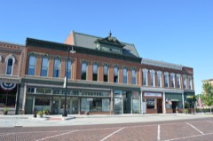 | Phoenix Opera House Block | building | 1985 | 85001010 |
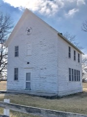 | White Oak Hall | building | 2003 | 02001757 |
The NOAA Storm Events Database holds 212 reports for this county, causing 1 death, 15 injuries and about $8,789,380 in recorded property damage. Each settlement page carries the reports that name it.
| Kind of event | Reports |
|---|---|
| Thunderstorm Wind | 98 |
| Hail | 54 |
| Flash Flood | 32 |
| Tornado | 21 |
| Flood | 6 |
| Lightning | 1 |
The most serious of them, by death, then injury, then recorded damage. The accounts are quoted exactly as the forecast office filed them.
| When | Event | Place named | Harm | What the report says |
|---|---|---|---|---|
| June 1981 | Tornado (F3) | not stated | 1 killed, 12 hurt, $2,500,000 | no account filed |
| March 1998 | Thunderstorm Wind | Camden | 2 hurt, $1,000,000 | As thunderstorms moved through Schuyler county, they destroyed several barns and grain bins in Camden. A Camden couple sustained injuries after being struck by a tree limb while they were standing in their yard watching the storm pass. Numerous windows were blown out in Rushville and a roof was torn off of a recycling plant 5 miles east of Rushville. The winds caused the rear wall of one business to collapse and another lost its roof in Rushville. Also, numerous cars at two dealerships were damaged, 2 satellite dishes and communications antennas were torn off the roof of a radio station and a storage building was demolished. In total, approximately $1 million dollars worth of damage was sustained in Schuyler county. |
| December 2018 | Lightning | Huntsville | 1 hurt | A lightning strike injured a person in Huntsville in Schuyler County. |
| April 2013 | Flash Flood | Bader | $2,000,000 | Torrential rainfall of 3.00 to 8.00 inches resulted in damage to hundreds of houses in the county, which included several basement walls which collapsed. Nearly every creek and stream in the county was flooded, which damaged a few bridges and culverts. Nearly every road in the county was also impassable with water one to two feet deep in spots. Several water rescues were made. |
| August 1999 | Hail | Rushville | $758,000 | Hail up to baseball size fell, especially to the north and west of Rushville. Hundreds of cars were damaged by the hail. Numerous houses sustained roof damage and thousands of acres of corn and soybeans damaged. |
| July 2010 | Flash Flood | Ray | $370,000 | Slow moving thunderstorms produced copious amounts of rainfall in much of Schuyler County late in the evening of July 28th. Nearly 5.00 of rain was measured in 90 minutes which produced nearly two feet of water on many rural roads. This rainfall event, combined with the heavy rain and flooding nine days earlier, produced extensive damage to 24 box culverts and bridges in northern and eastern Schuyler County. |
| December 2018 | Tornado (EF1) | Bluff City | $260,000 | A tornado touched down in an open field 1.9 miles southwest of Bluff City at 3:51 PM CST. The tornado tracked northeastward and damaged a couple of outbuildings before knocking a home off its foundation and doing tree damage in Bluff City along Highway 100. It then crossed from Schuyler County into far southern Fulton County at 3:55 PM CST. |
| May 1996 | Flash Flood | Countywide | $250,000 | no account filed |
| November 1990 | Tornado (F2) | not stated | $250,000 | no account filed |
| March 1990 | Tornado (F2) | not stated | $250,000 | no account filed |
| April 2013 | Flood | Bluff City | $100,000 | No homes were damaged by record levels of flooding on the Illinois River. However, thousands of acres of agricultural land and several roads adjacent to the river were damaged. The river stage at Beardstown climbed to a record level of 29.81 feet on April 27th at 01:25 local time, which was nearly 16 feet above flood stage. High impact flooding continued into the month of May 2013. |
| July 2010 | Flash Flood | Ray | $100,000 | Clusters of training thunderstorms produced excessive amounts of rainfall in Schuyler County during the late evening hours of July 19th. Rainfall rates of 2.00 per hour for more than 3 hours produced widespread flash flooding, which closed nearly every rural road and caused some road damage in northern and western parts of the county. Total rainfall accumulations reached nearly 8.00 in western Schuyler county near Camden and Huntsville. Two people suffered indirect injuries due to traffic accidents as a result of the flooded roads. |
| August 1999 | Thunderstorm Wind | Huntsville | $77,000 | Thunderstorm winds caused considerable damage in Schuyler county. Numerous trees, tree limbs, and power lines were blow down. Also, thousands of acres of corn were laid down by the winds. Crop damage was estimated around $2 million. In Rushville, one unoccupied truck was damaged when a tree fell onto it. Property damage was estimated around $77,000. |
| May 2013 | Thunderstorm Wind | Littleton | $70,000 | Several power poles were blown down along Highway 67 near Littleton. |
| June 2011 | Thunderstorm Wind | Littleton | $70,000 | Several barns and outbuildings experienced wind damage south of Littleton. |
| June 1999 | Tornado (F0) | Rushville | $60,000 | A tornado touched down 5.5 miles northwest of Rushville. As it travelled to the northeast it destroyed the roof of a machine shed and tipped over a camper and a fifth wheel. Numerous trees were blown over. Four and a half miles north northwest of Rushville, the tornado caused minor damage to two homes and the roof of a barn. Also, several power poles were snapped off at the base. The tornado lifted and dissipated 5 miles north of Rushville. No injuries were reported and damage was estimated around $60,000. |
| June 2018 | Thunderstorm Wind | Rushville | $50,000 | A large tree was split and fell onto a church. Numerous tree limbs and power lines were blown down as well. |
| June 2010 | Thunderstorm Wind | Rushville | $50,000 | Many trees, tree limbs, and power lines were blown down. |
| June 2014 | Thunderstorm Wind | Pleasant View | $45,000 | Several tree tops were broken off and tree limbs were blown down. A large cottonwood tree was blown down along Pokeberry Road. Damage occurred to tents at the fairgrounds northeast of Rushville. |
| June 2018 | Thunderstorm Wind | Rushville | $40,000 | Numerous trees were blown down in Rushville. |
| July 2008 | Thunderstorm Wind | Rushville | $40,000 | Trees and power poles were blown down in Rushville. |
| June 2011 | Thunderstorm Wind | Rushville | $32,000 | A tree was blown down onto a trailer on Madison Street in Rushville. |
| July 2010 | Thunderstorm Wind | Rushville | $32,000 | Numerous trees were blown down around town. The Subway restaurant had its door torn off. |
| June 2017 | Thunderstorm Wind | Rushville | $30,000 | Several large trees and tree branches were blown down. |
| June 2018 | Thunderstorm Wind | Brooklyn | $25,000 | Numerous trees were blown down in Brooklyn. |
| June 2014 | Thunderstorm Wind | Browning | $25,000 | Several power lines were knocked down in the town of Browning. |
| February 2011 | Thunderstorm Wind | Frederick | $25,000 | Numerous large tree limbs were blown down from Frederick to Browning. |
| March 1957 | Tornado (F2) | not stated | $25,000 | no account filed |
| July 2010 | Thunderstorm Wind | Browning | $24,000 | A few trees were blown down north of Browning. Crops were knocked down near Bader. |
| June 2017 | Thunderstorm Wind | Frederick | $20,000 | Numerous tree branches up to 15 inches in diameter were snapped off. |
| June 2015 | Thunderstorm Wind | Brooklyn | $20,000 | Numerous trees were blown down in Brooklyn. |
| May 2013 | Thunderstorm Wind | Huntsville | $20,000 | Several small trees were blown down at the Weinberg King State Fish and Wildlife Area. A few larger trees were knocked down along Highway 101 east of Augusta near the Schuyler/Hancock County line. |
| July 2010 | Thunderstorm Wind | Camden | $20,000 | Several large tree limbs were blown down. |
| August 2009 | Thunderstorm Wind | Rushville | $20,000 | Numerous large tree limbs were blown down in Rushville. |
| June 2008 | Thunderstorm Wind | Rushville | $20,000 | Numerous trees, tree limbs, and power lines were blown down in Rushville. |
| June 2009 | Thunderstorm Wind | Huntsville | $15,000 | Tree branches were blown down in the towns of Huntsville, Camden, and Rushville. |
| December 2018 | Tornado (EF1) | Brooklyn | $12,000 | A tornado touched down about 0.4 miles southwest of Brooklyn at 3:00 PM CST , then tracked north-northeastward and dissipated 1.1 miles north of Brooklyn at 3:02 PM CST. Only minor damage was reported during its brief time on the ground. |
| June 2014 | Thunderstorm Wind | Rushville | $12,000 | Three trees were blown down on Pokeberry Road about 2 miles northeast of Rushville. One of the trees fell on an unoccupied van. |
| June 2011 | Thunderstorm Wind | Brooklyn | $12,000 | One large tree was uprooted and several pine trees were snapped off west of Brooklyn. |
| March 2017 | Thunderstorm Wind | Huntsville | $10,000 | The roof of a house was damaged in Huntsville. |
| July 2013 | Thunderstorm Wind | Rushville | $10,000 | Shingles were damaged on a house and several 4-inch diameter trees were snapped on Curry Chapel Road about 1 mile south of Camden Road. |
| August 2009 | Thunderstorm Wind | Brooklyn | $10,000 | Power lines were blown down in Brooklyn. |
| December 2008 | Thunderstorm Wind | Littleton | $10,000 | The roof was blown off a barn. |
| April 1997 | Thunderstorm Wind | Rushville | $7,800 | Thunderstorm winds blew down several trees, one of which blocked Route 24 just north of Rushville. In Rushville, the winds damaged the library roof causing $7,800 in damage. No injuries were reported. |
| February 2011 | Hail | Ray | $5,000 | Golfball-sized hail broke windows at a home 2 miles north of Ray. |
| March 1985 | Tornado (F1) | not stated | $2,500 | no account filed |
| May 2015 | Thunderstorm Wind | Littleton | $2,000 | A tree was blown down on Route 101 just west of Littleton. |
| July 2008 | Thunderstorm Wind | Rushville | $2,000 | A large tree was blown down 4 miles west of Rushville. |
| August 1993 | Thunderstorm Wind | Brooklyn | $500 | Large tree limbs were blown down according to the Schuyler County Sheriff's Office. |
| August 1993 | Thunderstorm Wind | Camden | $500 | Large tree limbs were blown down. |
| August 1993 | Thunderstorm Wind | Huntsville | $50 | Large tree limbs were blown down. |
| May 1982 | Tornado (F0) | not stated | $30 | no account filed |
| March 2025 | Thunderstorm Wind | Rushville | - | Several tree branches were blown down onto power lines, resulting in a power outage. |
| December 2025 | Thunderstorm Wind | Rushville | - | An empty semi-truck was tipped over on Route 24 northeast of Rushville. |
| July 2024 | Thunderstorm Wind | Rushville Arpt | - | Tree branches were snapped and a few power poles were blown down along Highway 67 northwest of Rushville. |
| May 2024 | Thunderstorm Wind | Camden | - | Trees were blown down near intersection of Camden Road and Daly Lane. |
| May 2024 | Thunderstorm Wind | Littleton | - | Structural damage occurred to a small pole barn. |
| May 2024 | Thunderstorm Wind | Littleton | - | A mobile home sustained considerable structural damage. |
| May 2024 | Thunderstorm Wind | Littleton | - | Power poles were blown down on Highway 67. |
| July 2024 | Thunderstorm Wind | Rushville | - | Several tree branches were blown down throughout town, including some that fell onto power lines. One large tree was blown over. |
The Survey's mineral resources record lists 13 workings inside this county. 3 still produce and 10 are closed or unrecorded. Each settlement page carries the workings within five miles of it.
| Commodity | Workings |
|---|---|
| Sand and Gravel, Construction | 8 |
| Stone, Crushed/Broken | 4 |
| Clay | 1 |
The least common of them first, because a county's hundredth gravel pit says nothing its first ten did not.
| Where | Site | Commodity | Status | Recorded |
|---|---|---|---|---|
| Carbondale Shale Exposure | Clay | Prospect | ||
| General Pit & Mill | Stone, Crushed/Broken | Plant | ||
| Hammitt Quarry | Stone, Crushed/Broken | Producer | ||
| Lickey Quarry | Stone, Crushed/Broken | Past Producer | ||
| Schuyler Highway Department | Stone, Crushed/Broken | Past Producer | ||
| Blend Sand Pit | Sand and Gravel, Construction | Past Producer | ||
| Coal Creek Pit | Sand and Gravel, Construction | Producer | ||
| Damon Quarry No. 11 | Sand and Gravel, Construction | Past Producer | ||
| Donaldson Pit | Sand and Gravel, Construction | Past Producer | ||
| Leland Jacobs Farm Pit | Sand and Gravel, Construction | Past Producer | ||
| Old John Smith Pit | Sand and Gravel, Construction | Past Producer | ||
| Sheldon Grove Sand & Gravel Pit | Sand and Gravel, Construction | Past Producer | ||
| Sugar Grove Pit | Sand and Gravel, Construction | Past Producer |
Named settlements recorded in the Geographic Names Information System, each with the topographic sheets covering it. Villages, hamlets and abandoned places alike. Each is shown with the nearest named watercourse or landform and the survey quadrangle it falls on.
Browning township · 62624 · On Dutchmans Creek · Astoria quadrangle
15 sheets, 1926 to 1990
Frederick township · 62639 · On Coal Creek · Beardstown quadrangle
16 sheets, 1926 to 1990
Buena Vista township · 62681 · Erwin quadrangle
14 sheets, 1923 to 1990
No longer a settlement
Huntsville township · 62346 · On Grand Tower Branch · Camden quadrangle
14 sheets, 1946 to 1990
Oakland township · 62681 · On West Branch Sugar Creek · Rushville North quadrangle
15 sheets, 1923 to 1990
The vanished settlements of Schuyler County: the places named above that are no longer on the map.