BlockBefore
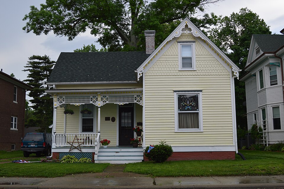
Photograph of George Draser, Jr., Houses
Photograph by Nyttend, Public domain. Via Wikimedia Commons.

George Draser Jr. House

Listed on the National Register of Historic Places in 2000.

From the record

“Houses are a pair of neighboring houses located at 48 and 52 W. The houses are both Queen Anne structures designed and built by local architect George Draser Jr.”

Wikipedia article George Draser Jr. Houses, CC BY-SA 4.0.

One of 27 National Register listings published here for St. Clair County · listed in 2000 · category: Building.

Sources: the Wikipedia article · the case file at the National Archives · the National Register database, National Park Service
The listing

  • What is counted as historic. The nomination lists 4 buildingss, 3 structuress as contributing to the listing.
  • Listed as. Draser, George, Jr., House - the National Register files a house under its owner's surname.
  • Address. 48 and 52 W. Main St., Mascoutah, 62258
  • When was it listed? May 2000
  • Category. building
  • Township. Mascoutah township
  • Architectural style. Queen Anne style architecture in the United States
  • National Register reference number. 00000474 - the number the National Park Service assigned this property when it was listed, and the key its nomination file is catalogued under at the National Archives.

The ground it stands on

326 words

The chapter on Mascoutah Township in Centennial, McKendree College, with St. Clair County History, published 1928 names Mascoutah. This is what it says, exactly as the scans read.

Samuel Dixon built the first house withm the limits of the present town of Mascoutah. Dixon was a hunter and lived just south of where the Postel Mills now stand. The town was laid out on the sixth of April, i8j7 by T. J. Krafft and John Flanagan. It contained six blocks of different sizes and was called Mechanicsburg. After the town was laid out Samuel Mitchell built a log cabin and established a saw mill . In 1839 an addition was made containing seventy-two lots, by Hilgard, Krafft, and Benjamin West. At this time the name was changed to Mascoutah. Many other additions have been laid out since then. Dr. Smith, a son-in-law of Major Brown, was the first physician in the place. The first school house was erected just north of the Postel mill. Nathan Fike was the first postmaster. Conrad and Philip Eisenmayer purchased the mill property in 1839. They soon took in as a partner Philip H. Postel. They enlarged the mill and became exporters of flour. The second mill, erected near the old site was built by Andrew Eisenmayer and Philip Postel in 1848 and now known as the Postel Mills. It has been enlarged and improved until now it is one of the largest mills in this section of the country, having a capacity of three hundred and fifty barrels of flour a day. The growth was slow until the German immigrants began to come about 1840 and later. Since then the growth of the town has been steady and now Mascoutah is one of the fine towns of the county. It has six churches, a fine public school system, including a community high school, a hat factory, a rubber goods factory, a municipal water works and lighting system. Good hotels, some fine stores and business houses of various kinds. Illinois State highway No. 1 5 runs right through the principal street and there is bus service to St. Louis.

Passage source: Centennial, McKendree College, with St. Clair County History, published 1928.

Machine-read from a century-old scan, so expect the errors a machine makes: misspelled names, dropped words, stray characters.

Read the whole chapter on Mascoutah Township - 326 words on its settlement, mills, schools and churches.

Storms near this property

50 since 1994

Regional context, not property-specific evidence. The National Weather Service names Mascoutah, the town this property stands in, in 50 storm reports between 1994 and 2025: 26 thunderstorm wind, 22 hail, 1 flash flood, 1 tornado. No death or injury is recorded in these reports. Each account below is quoted exactly as the forecast office filed it, from the NOAA Storm Events Database, and each date opens the federal record of that event.

WhenEvent Place namedHarm What the report says
March 2025Tornado (EF1)Mascoutah$260,000At approximately 10:30 PM, a tornado began near Scheve Park in Mascoutah. In Mascoutah the tornado caused roof damage to multiple residences as well as the local high school. Power poles and outbuildings were damaged as well. The most intense damage in town occurred near the intersection of Beechcraft Blvd and Fuesser Rd. The tornado continued northeast where it damaged a grain elevator and more farm outbuildings. The most significant damage in the county occurred near the Madison/Clinton County border where farm outbuildings were completely destroyed and residences sustained heavy roof and window damage. The tornado then crossed into Clinton County. In St. Clair County the tornado was rated EF-1 with a path length of 7.88 miles and a maximum path width of 700 yards.
July 2021Thunderstorm WindMascoutah$20,000Thunderstorm winds blew down numerous large tree limbs, up to 12 inches in diameter, throughout Mascoutah. A utility pole was snapped off at its base. A couple of trees, as well as numerous tree limbs, were snapped off along Highbanks Road. A flag pole was also bent.
May 1995Thunderstorm WindMascoutah$15,000The roof of an apartment complex collapsed after being damaged from high winds. Numerous large trees and power lines were blown down through out the Mascoutah area. Reported by ham radio spotters.
May 2008Thunderstorm WindMascoutah$10,000The local 911 center reported many tree limbs down on streets in Mascoutah. Minor roof damage was also reported.
May 2022Thunderstorm WindMascoutah$5,000Thunderstorm winds blew down numerous tree limbs around town.
October 2001Thunderstorm WindMascoutah$5,000Wind gusts downed a tree which fell on a parked school bus causing minor roof damage. No one was on the bus at the time.
May 1995Thunderstorm WindMascoutah$300County officials reported power lines and poles down.
August 2019Thunderstorm WindMascoutah-Thunderstorm winds blew down a large tree onto an unoccupied car just south southeast of Mascoutah.
March 2017Thunderstorm WindMascoutah-Thunderstorm winds blew down several trees, tree limbs and power lines around town.
July 2014HailMascoutah-Lots of quarter sized hail was reported over Mascoutah.
July 2013Thunderstorm WindMascoutah-Thunderstorm winds blew down several tree limbs and power lines. Also, a few large trees were snapped off.
February 2011Thunderstorm WindMascoutah-Thunderstorm winds blew over a semi on Illinois Route 177 east of Mascoutah. No injuries were reported.
April 2011Flash FloodMascoutah-Up to three inches of rain fell in a short amount of time causing flash flooding. Several roads had water over them including Illinois Route 4 south of Mascoutah and up to 10 inches deep on the northside of Freeburg on Deerfield Court.
December 2010Thunderstorm WindMascoutah-Thunderstorm winds blew some siding off of a house and outbuildings.
June 2008Thunderstorm WindMascoutah-Thunderstorm winds uprooted and blew over two large trees as well as numerous tree limbs in Mascoutah.
June 2008Thunderstorm WindMascoutah-Several large trees were blown down southeast and east of Mascoutah.
May 2007HailMascoutah-Amateur radio spotters reported 3/4 inch hail northwest of Mascoutah.
July 2006Thunderstorm WindMascoutah-Numerous large tree limbs were blown down.
June 2005Thunderstorm WindMascoutah-The local electric cooperative reported 4 power poles broken along Highway 177.
May 2004HailMascoutah-Storm spotters reported 3/4 inch hail.
June 2003Thunderstorm WindMascoutah-Thunderstorm wind gusts downed numerous trees and power lines across the area.
May 2000HailMascoutah-Storm spotters reported 3/4 inch hail in Mascoutah.
June 2000Thunderstorm WindMascoutah-Storm spotters reported trees down in Mascoutah.
April 1994HailMascoutah-Several large trees were knocked down in Dupo and wind gusts as high as 70 mph were reported by ham radio spotters in Belleville. Quarter-size hail was also reported in Freeburg and dime-size hail was reported in Mascoutah.
March 2024HailMascoutah-no account filed
March 2017Thunderstorm WindMascoutah-no account filed
September 2012HailMascoutah-no account filed
April 2012HailMascoutah-no account filed
June 2011Thunderstorm WindMascoutah-no account filed
May 2011HailMascoutah-no account filed
June 2010HailMascoutah-no account filed
May 2010HailMascoutah-no account filed
June 2009HailMascoutah-no account filed
April 2008HailMascoutah-no account filed
June 2008HailMascoutah-no account filed
May 2008HailMascoutah-no account filed
April 2007HailMascoutah-no account filed
February 2006HailMascoutah-no account filed
July 2005Thunderstorm WindMascoutah-no account filed
July 2002Thunderstorm WindMascoutah-no account filed
August 2001Thunderstorm WindMascoutah-no account filed
June 2000Thunderstorm WindMascoutah-no account filed
February 1999Thunderstorm WindMascoutah-no account filed
June 1998Thunderstorm WindMascoutah-no account filed
April 1996HailMascoutah-no account filed
October 1996Thunderstorm WindMascoutah-no account filed

Every storm recorded in St. Clair County

Map coverage status

No historic map-sheet match is published for this property yet. That does not mean no map exists. This record needs a coordinate-quality review before it can be joined to a sheet boundary. Browse the county's mapped places while that work is pending.

Listed places nearby

5 within 8 miles

Other National Register properties close enough to walk or drive between, ordered by distance from this one. Both positions come from the same geocoding pass that matched these properties to their map sheets.

Photograph PropertyDistance Listed
Berger-Kiel House0.8 miles1999
Scott Field Historic District4.8 miles1994
Turkey Hill Grange Hall7.6 miles2016
Lebanon Historic District7.8 miles1978
Mermaid House Hotel7.8 miles1975

Sources for this property

National Archives recordThe nomination case file for reference 00000474 in Record Group 79.
Wikipedia articleCommunity-written account of this property, licensed CC BY-SA.
St. Clair CountyAll 27 listed properties in this county.

Provenance

  • Listing record. National Park Service National Register of Historic Places, listed-properties dataset, current to 2026-05-22.
  • Map join. Address geocoded through the United States Census geocoder, then tested against the published boundary of every sheet in the USGS Historical Topographic Map Collection.
  • How this page is made. Listing fields come from federal records; map-sheet coverage is a labelled coordinate-to-boundary calculation, not a source-field claim.
  • Storms. NOAA National Centers for Environmental Information, Storm Events Database https://www.ncei.noaa.gov/stormevents/ A work of the United States government, no copyright under 17 U.S.C. 105. Narratives are quoted verbatim from the National Weather Service report and are not edited or summarised.