BlockBefore
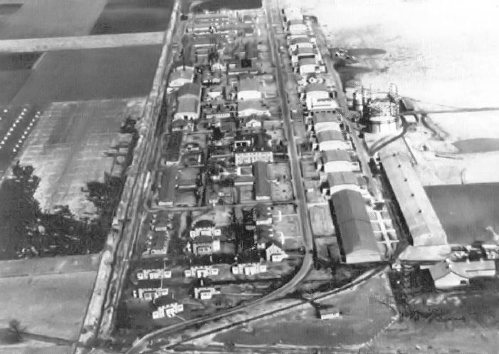
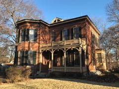
Photograph of Scott Field Historic District
Photograph by United States Army Air Corps, Public domain. Via Wikimedia Commons.

Scott Field Historic District

Listed on the National Register of Historic Places in 1994.

From the record

“Scott Field Historic District began as a World War I era air base built in 1917 near O'Fallon, Illinois, and was expanded and rebuilt before World War II. The district contains primarily that portion of the base built prior to 1941, and is now contained within the renamed, expanded, and operational Scott Air Force Base.”

Wikipedia article Scott Field Historic District, CC BY-SA 4.0.

One of 27 National Register listings published here for St. Clair County · listed in 1994 · category: District.

Sources: the Wikipedia article · the case file at the National Archives · the National Register database, National Park Service
The listing

  • Address. Roughly bounded by Scott Dr. and Hanger Rd., O'Fallon, 62225
  • When was it listed? March 1994
  • Category. district
  • Township. Shiloh Valley township
  • National Register reference number. 94000060 - the number the National Park Service assigned this property when it was listed, and the key its nomination file is catalogued under at the National Archives.

The ground it stands on

4,315 words

The chapter on Shiloh Valley Township in History of St. Clair County, Illinois. With Illustrations ... and Biographical Sketches of Some of Its Prominent Men and Pioneers, published 1881 names O'Fallon. This is what it says, exactly as the scans read.

The first house erected in the village proper was by Edwin Pierce, in 1845. It is still standing, just in the rear of the church, and is known as the Gaag house. The next dwelling was built by Robert Dorey. Jacob Canmann erected the first store-house and opened the first stock of goods for sale, in 1845. Andrew Haege erected two or three houses, and his brother Jacob erected a dwelling and blacksmith shop about the same date. Jacob Haege was the first blacksmith. A steam saw-mill was erected by Edwin Pierce, Philip Scott and Charles Alexander, about 1847. The village is located in the north-western part of the precinct, near the O'Fallon line, and was laid out by Martin Stites and James Atkins.

Passage source: History of St. Clair County, Illinois. With Illustrations ... and Biographical Sketches of Some of Its Prominent Men and Pioneers, published 1881.

|HIS is one of the northern tier of precints, bounded on the north by Madison county, east by O'Fallon, south by O'Fallon and French Village, and west by East St. Louis. It contains twenty-three sections or about 14,720 acres. It is drained by Canteen creek and its affluents in the northern and eastern part, and the Grand Marias in the south-western. Caseyville, situated a little north of the geographical centre of the precinct is the only village within its borders. The Ohio & Mississippi, and the St. Louis, Vandalia & Terre Haute Railroads enter the western part of the precinct and run side-by-side until they reach Caseyville, when the latter takes a north-easterly course and passes out on section three. From Caseyville the 0. & M. runs in a south-easterly course and passes out on section 27. The surface of the precinct is divided between bottom lands And bluffs. The line separating the two passes through Caseyville in nearly a north-eastern and southwestern direction from that point. In early times the bottom lands included in this precinct were covered with water the greater part of the year, and only for a few years back have they been drained so as to insure crops when sown. The bluffs in the region of Caseyville are very rugged, and mostly covered with a heavy growth of timber. They are composed principally of sand, clay and gravel. Hence, from these facts, the territory embracing Caseyville was not so early settled as some of the precincts adjoining it.

Passage source: History of St. Clair County, Illinois. With Illustrations ... and Biographical Sketches of Some of Its Prominent Men and Pioneers, published 1881.

Machine-read from a century-old scan, so expect the errors a machine makes: misspelled names, dropped words, stray characters.

Read the whole chapter on Shiloh Valley Township - 4,315 words on its settlement, mills, schools and churches.

Storms near this property

31 since 1995

Regional context, not property-specific evidence. The National Weather Service names O'Fallon, the town this property stands in, in 31 storm reports between 1995 and 2025: 17 thunderstorm wind, 13 hail, 1 tornado. The reports record 2 injuries. Each account below is quoted exactly as the forecast office filed it, from the NOAA Storm Events Database, and each date opens the federal record of that event.

WhenEvent Place namedHarm What the report says
March 2025Thunderstorm WindO Fallon2 hurt, $150,000Thunderstorm winds caused a home to collapse with two elderly residents inside.
March 2025Tornado (EF1)O Fallon$150,000At approximately 10:28 PM a tornado began in the northeastern outskirts of O'Fallon, IL where it caused damage to multiple mobile homes, single family homes, outbuildings, and trees along its track northeast. The tornado then passed into southern Madison County. In Madison County the tornado was rated EF-1 with a path length of 6.75 miles and a maximum path width of 770 yards. In St. Clair County the tornado was rated EF-1 with a path length of 5.9 miles and a maximum path width of 450 yards.
May 1995Thunderstorm WindO'Fallon$800Numerous power lines and large trees were knocked down across the county.
March 2025HailO Fallon-Wind driven hail caused extensive damage to west facing homes and buildings.
March 2025Thunderstorm WindO Fallon-Thunderstorm winds snapped a large tree which fell onto a house and its deck.
March 2025Thunderstorm WindO Fallon-Thunderstorm wind driven hail destroyed the siding and windows on numerous homes spanning entire neighborhoods in O'Fallon.
June 2013Thunderstorm WindO Fallon-Thunderstorm winds blew down a 6 inch diameter tree.
July 2009Thunderstorm WindO Fallon-Several trees and power lines were blown down. Also, one house sustained minor siding damage.
July 2006Thunderstorm WindO Fallon-Several large trees and tree limbs were blown down.
July 2006Thunderstorm WindO Fallon-Several large tree limbs were blown down.
March 2025HailO Fallon-no account filed
August 2019HailO Fallon-no account filed
May 2018HailO Fallon-no account filed
May 2013HailO Fallon-no account filed
March 2012HailO Fallon-no account filed
May 2010HailO Fallon-no account filed
June 2009HailO Fallon-no account filed
June 2005Thunderstorm WindO Fallon-no account filed
May 2004HailO Fallon-no account filed
July 2004Thunderstorm WindO Fallon-no account filed
June 2003Thunderstorm WindO Fallon-no account filed
July 2002Thunderstorm WindO Fallon-no account filed
July 2001Thunderstorm WindO Fallon-no account filed
August 2000Thunderstorm WindO Fallon-no account filed
February 1999HailO Fallon-no account filed
May 1998Thunderstorm WindO Fallon-no account filed
April 1996HailO Fallon-no account filed

Every storm recorded in St. Clair County

Map coverage status

No historic map-sheet match is published for this property yet. That does not mean no map exists. This record needs a coordinate-quality review before it can be joined to a sheet boundary. Browse the county's mapped places while that work is pending.

Listed places nearby

6 within 8 miles

Other National Register properties close enough to walk or drive between, ordered by distance from this one. Both positions come from the same geocoding pass that matched these properties to their map sheets.

Photograph PropertyDistance Listed
Berger-Kiel House4.0 miles1999
Tiedemann House4.7 miles2020
George Draser Jr. House4.8 miles2000
Lebanon Historic District5.1 miles1978
Mermaid House Hotel5.4 miles1975
Turkey Hill Grange Hall6.0 miles2016

Sources for this property

National Archives recordThe nomination case file for reference 94000060 in Record Group 79.
Wikipedia articleCommunity-written account of this property, licensed CC BY-SA.
St. Clair CountyAll 27 listed properties in this county.

Provenance

  • Listing record. National Park Service National Register of Historic Places, listed-properties dataset, current to 2026-05-22.
  • Map join. Address geocoded through the United States Census geocoder, then tested against the published boundary of every sheet in the USGS Historical Topographic Map Collection.
  • How this page is made. Listing fields come from federal records; map-sheet coverage is a labelled coordinate-to-boundary calculation, not a source-field claim.
  • Storms. NOAA National Centers for Environmental Information, Storm Events Database https://www.ncei.noaa.gov/stormevents/ A work of the United States government, no copyright under 17 U.S.C. 105. Narratives are quoted verbatim from the National Weather Service report and are not edited or summarised.