 Block
From the record
One of 13 National Register listings published here for Montgomery County · listed in 2001 · category: Structure.
Sources: the case file at the National Archives · the National Register database, National Park Service
Listed on the National Register of Historic Places in 2001.
One of 13 National Register listings published here for Montgomery County · listed in 2001 · category: Structure.
Sources: the case file at the National Archives · the National Register database, National Park Service
Regional context, not property-specific evidence. The federal wildfire occurrence database lists 4 fires within 5 miles of Route 66, Litchfield to Mount Olive between 2008 and 2009, burning about 3 acres in total. None started naturally. None was recorded as arson. Distance is straight-line from the map coordinates, so a fire counted here may appear on a neighbouring settlement's page as well.
| Reported cause | Fires |
|---|---|
| Missing data/not specified/undetermined | 4 |
The most recent of them, most recent first, with the day each was reported and the service that recorded it.
| Date | Cause | Size | Reported by | Name on the report |
|---|---|---|---|---|
| 4 April 2009 | Missing data/not specified/undetermined | under an acre | Illinois Division of Forestry Resources | EAGARVILLE |
| 20 January 2008 | Missing data/not specified/undetermined | 1.0 acres | Illinois Division of Forestry Resources | PRAIRIE |
| 15 January 2009 | Missing data/not specified/undetermined | under an acre | Illinois Division of Forestry Resources | RT. 16 |
| 14 January 2009 | Missing data/not specified/undetermined | under an acre | Illinois Division of Forestry Resources | MINENICH |
Regional context, not property-specific evidence. The federal mineral resources record lists 1 working within 5 miles of Route 66, Litchfield to Mount Olive: 1 past producer. None of them still produces. What was taken out: Stone, Crushed/Broken. Distance is straight-line from the map coordinates, so a quarry counted here may appear on a neighbouring settlement's page as well.
| Where | Site | Commodity | Status | Recorded |
|---|---|---|---|---|
| Kiggins Crushed Stone Co. Quarry | Stone, Crushed/Broken | Past Producer |
Regional context, not property-specific evidence. The National Weather Service names Litchfield, the town this property stands in, in 70 storm reports between 1993 and 2024: 43 hail, 25 thunderstorm wind, 2 tornado. No death or injury is recorded in these reports. Each account below is quoted exactly as the forecast office filed it, from the NOAA Storm Events Database, and each date opens the federal record of that event.
| When | Event | Place named | Harm | What the report says |
|---|---|---|---|---|
| May 2024 | Thunderstorm Wind | Litchfield | $5,000 | Thunderstorm winds knocked a tree atop a mobile home, knocked numerous limbs down, and flattened an estimated acre of wheat field on the south side of Litchfield. |
| June 2023 | Thunderstorm Wind | Litchfield | - | Thunderstorm winds blew down numerous trees, tree limbs and several power lines across Montgomery County, especially in Litchfield, Hillsboro, Butler, Irving, Witt and Nokomis. |
| June 2019 | Thunderstorm Wind | Litchfield | - | Thunderstorm winds blew down numerous large tree limbs. |
| December 2018 | Tornado (EF2) | Litchfield | - | The tornado first touched down just southeast of Litchfield, IL, along Old Litchfield Trail where large tree branches were snapped. The damage worsened as the tornado moved northeast, where a large farm building was destroyed near Illinois Route 16. The tornado then crossed to the north of Illinois Route 16, doing damage along Rocky Hollow Trail. This area sustained the worst of the tornadic damage, where several farm buildings were destroyed. A brick family residence sustained major roof damage and suffered a partial loss of its walls in this location as well. The tornado then continued to the northeast, weakening and eventually lifting as it turned to the west towards E 7th Road. This curvature in the tornado path made the path length 7.93 miles. However, can only plot two points went entering tornado information, thus path length in the header is indicating 6.79 miles. Overall, the tornado was rated EF2 with a path length of 7.93 miles and a max path width of 100 yards. No injuries or deaths were reported with this tornado. |
| July 2017 | Thunderstorm Wind | Litchfield | - | Thunderstorm winds caused minor damage to buildings at a business on the west side of Litchfield. In Raymond, numerous tree limbs were blown down and some shingles were blown off roofs. |
| March 2017 | Thunderstorm Wind | Litchfield | - | Thunderstorm winds snapped off several large tree limbs. |
| June 2017 | Thunderstorm Wind | Litchfield | - | Thunderstorm winds blew down a few power lines around town. |
| April 2017 | Thunderstorm Wind | Litchfield | - | Thunderstorm winds blew down several power lines on the east side of town. |
| May 2016 | Thunderstorm Wind | Litchfield | - | Thunderstorm winds blew down several large trees as well as numerous tree limbs. Also, a house in Litchfield had several shingles blown off of it's roof. |
| October 2012 | Thunderstorm Wind | Litchfield | - | Thunderstorm winds blew down several large trees around town. |
| June 2011 | Hail | Litchfield | - | Golfball sized hail on Illinois Route 16 about 3 miles east of Litchfield. |
| August 2010 | Thunderstorm Wind | Litchfield | - | Thunderstorm winds caused widespread damage on the north side of Litchfield. Numerous trees, tree limbs and power lines were blown down. A couple of homes in the area sustained minor roof damage. |
| May 2008 | Thunderstorm Wind | Litchfield | - | Local law enforcement reported a couple of trees blown over, large limbs down, and a few power lines down. An electric transformer was also damaged which resulted in the high school and junior high school losing power. |
| August 2007 | Thunderstorm Wind | Litchfield | - | Several power lines were blown down. |
| June 2006 | Thunderstorm Wind | Litchfield | - | Several large tree limbs were blown down. A few of the limbs landed on power lines in Litchfield. |
| June 2005 | Thunderstorm Wind | Litchfield | - | Thunderstorm winds knocked down a tree and power lines on Washboard Trail Road. |
| June 2005 | Thunderstorm Wind | Litchfield | - | Storm spotters and local law enforcement reported a few trees and large tree limbs down in Litchfield. One tree fell on a car and large branches fell on power lines causing power outages. |
| November 2005 | Hail | Litchfield | - | Local law enforcement reported 3/4 inch hail south of Litchfield. |
| April 2003 | Hail | Litchfield | - | Storm spotters reported 3/4 inch hail. |
| May 2003 | Hail | Litchfield | - | The Illinois State Police reported 3/4 inch hail. |
| August 2000 | Hail | Litchfield | - | Storm spotters reported 3/4 inch hail northwest of Litchfield. |
| August 1993 | Tornado (F0) | Litchfield | - | A tornado briefly touched down near Interstate 55 and Highway 108, 7 miles north of Litchfield. No damage was reported. |
| May 2023 | Hail | Litchfield | - | no account filed |
| June 2017 | Hail | Litchfield | - | no account filed |
| April 2012 | Hail | Litchfield | - | no account filed |
| May 2011 | Hail | Litchfield | - | no account filed |
| February 2011 | Thunderstorm Wind | Litchfield | - | no account filed |
| April 2011 | Hail | Litchfield | - | no account filed |
| May 2011 | Hail | Litchfield | - | no account filed |
| June 2010 | Hail | Litchfield | - | no account filed |
| September 2010 | Hail | Litchfield | - | no account filed |
| July 2010 | Thunderstorm Wind | Litchfield | - | no account filed |
| June 2009 | Hail | Litchfield | - | no account filed |
| May 2009 | Hail | Litchfield | - | no account filed |
| February 2008 | Hail | Litchfield | - | no account filed |
| July 2008 | Hail | Litchfield | - | no account filed |
| April 2008 | Hail | Litchfield | - | no account filed |
| April 2008 | Hail | Litchfield | - | no account filed |
| March 2007 | Hail | Litchfield | - | no account filed |
| June 2007 | Hail | Litchfield | - | no account filed |
| July 2006 | Hail | Litchfield | - | no account filed |
| July 2006 | Hail | Litchfield | - | no account filed |
| May 2005 | Hail | Litchfield | - | no account filed |
| May 2004 | Thunderstorm Wind | Litchfield | - | no account filed |
| May 2004 | Thunderstorm Wind | Litchfield | - | no account filed |
| May 2004 | Thunderstorm Wind | Litchfield | - | no account filed |
| May 2004 | Thunderstorm Wind | Litchfield | - | no account filed |
| May 2004 | Thunderstorm Wind | Litchfield | - | no account filed |
| October 2004 | Hail | Litchfield | - | no account filed |
| October 2004 | Hail | Litchfield | - | no account filed |
| October 2004 | Hail | Litchfield | - | no account filed |
| October 2004 | Hail | Litchfield | - | no account filed |
| October 2004 | Hail | Litchfield | - | no account filed |
| October 2004 | Hail | Litchfield | - | no account filed |
| April 2003 | Hail | Litchfield | - | no account filed |
| June 2002 | Thunderstorm Wind | Litchfield | - | no account filed |
| May 2002 | Thunderstorm Wind | Litchfield | - | no account filed |
| April 2002 | Hail | Litchfield | - | no account filed |
| April 2002 | Hail | Litchfield | - | no account filed |
| May 2002 | Hail | Litchfield | - | no account filed |
No historic map-sheet match is published for this property yet. That does not mean no map exists. This record needs a coordinate-quality review before it can be joined to a sheet boundary. Browse the county's mapped places while that work is pending.
Other National Register properties close enough to walk or drive between, ordered by distance from this one. Both positions come from the same geocoding pass that matched these properties to their map sheets.
| Photograph | Property | Distance | Listed |
|---|---|---|---|
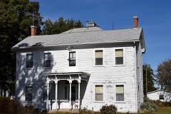 | Manske-Niemann Farm | 0.9 miles | 2003 |
 | Belvidere Cafe, Motel and Gas Station | 3.0 miles | 2007 |
| Ariston Cafe | 3.3 miles | 2006 | |
 | Brown Shoe Company Factory | 3.6 miles | 2006 |
 | Litchfield Public Library | 3.7 miles | 1999 |
 | Litchfield Elks Lodge No. 654 | 3.8 miles | 1995 |
| National Archives record | The nomination case file for reference 01001312 in Record Group 79. |
| Montgomery County | All 13 listed properties in this county. |