
BlockBefore
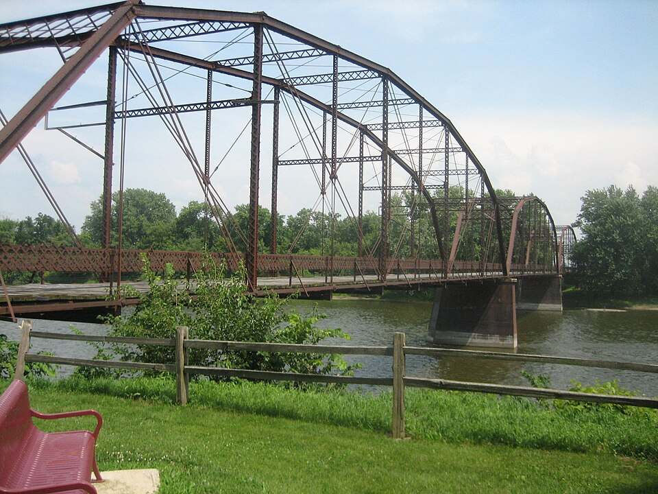
Photograph of Lyndon Bridge
Photograph by IvoShandor, CC BY 2.5. Via Wikimedia Commons.

Lyndon Bridge

Listed on the National Register of Historic Places in 2003.

From the record

“The Lyndon Bridge is a metal Parker Pratt through truss bridge in the village of Lyndon, Whiteside County, Illinois, United States. The Lyndon Bridge was designed by engineer R.S.”

Wikipedia article Lyndon Bridge, CC BY-SA 4.0.

One of 11 National Register listings published here for Whiteside County · listed in 2003 · category: Structure.

Sources: the Wikipedia article · the case file at the National Archives · the National Register database, National Park Service

The listing

  • What is counted as historic. The nomination lists 1 structure as contributing to the listing.
  • Address. S end of 6th Ave. W, Lyndon, 61277
  • When was it listed? May 2003
  • Category. structure
  • Township. Prophetstown township
  • National Register reference number. 03000353 - the number the National Park Service assigned this property when it was listed, and the key its nomination file is catalogued under at the National Archives.

The ground it stands on

20,495 words

The chapter on Prophetstown Township in History of Whiteside County, Illinois, from Its First Settlement to the Present Time;, published 1877 names Lyndon. This is what it says, exactly as the scans read.

Marvin Frary was born in Massachusetts, in 1799. In 1802, he went with his father's family to Ontario county, New York, where he grew to manhood, and then located in Cattaraugus county, New York. In the early part of 1835, he came to Prophetstown, and made a claim between the present villages of Prophetstown and Portland, which he afterwards sold to Fred Dwight, and bought the claim of Norman B. Seely. In addition to farming he was engaged for a time in the distilling business in Portland. Mr. Frary first married Miss Mary E. Seely, but they were divorced, and he afterwards married Mrs. E. S. Ellithrope, widow of Sampson Ellithrope. The children by the first marriage were : Myron, who died in 1836, and Caroline who married Joshua Bennidum, and is now dead. By the second marriage there was only one child, Delia, who married Fernando Brewer, and lives in Lyndon. Mr. Frary died in Prophetstown.

Passage source: History of Whiteside County, Illinois, from Its First Settlement to the Present Time;, published 1877.

At that time there were no houses on the south side of Rock river from Dixon down, until the grove just above Prophetstown was reached, where there were two cabins, one occupied by Mr. McClure and the other by Mr. Bestwick, an Englishman. Messrs. Wright and Perkins made a claim adjoining Asa Crook's, and which took in the land on which the village of Prophetstown now stands, and also enough of the bend of the river below to make what they considered two good-sized farms. Perkins soon after returned to Kendall county, while Mr. Wright remained to hold possession, and make improvements, and eventually purchased the interest of Perkins. Mr. Wright then took R. Ammidon as a partner, and the claim was divided. In 1836 he sold his share, with the exception of twenty acres which had been previously conveyed, to Jabez Warner, who had then just come up the river with a flat boat loaded with flour and provisions. He then went a few miles further up the river, made another claim, and commenced improvements, but having had the chills and fever for most of the time for two years, reluctantly left Whiteside county in the fall of 1839, and settled near Lisbon, Kendall county. Mr. Wright married Miss Sophrona Clark, daughter of W. L. Clark, of Lyndon Precinct, in October, 1840. Their children have been: Julia, Emily, Clara, and Lottie, all of whom are now living, and married; they have also had three others, who are now dead.

Passage source: History of Whiteside County, Illinois, from Its First Settlement to the Present Time;, published 1877.

Machine-read from a century-old scan, so expect the errors a machine makes: misspelled names, dropped words, stray characters.

Read the whole chapter on Prophetstown Township - 20,495 words on its settlement, mills, schools and churches.

Mines and quarries near this property

2 within 5 miles

Regional context, not property-specific evidence. The federal mineral resources record lists 2 workings within 5 miles of Lyndon Bridge: 1 producer, 1 past producer. 1 still produces. What was taken out: Sand and Gravel, Construction. Distance is straight-line from the map coordinates, so a quarry counted here may appear on a neighbouring settlement's page as well.

Where SiteCommodity StatusRecorded
Collinson Pit and MillSand and Gravel, ConstructionProducer
Lynden PitSand and Gravel, ConstructionPast Producer

Every working recorded in Whiteside County

Storms near this property

11 since 1994

Regional context, not property-specific evidence. The National Weather Service names Lyndon, the town this property stands in, in 11 storm reports between 1994 and 2022: 5 thunderstorm wind, 2 hail, 1 tornado, 1 funnel cloud. No death or injury is recorded in these reports. Each account below is quoted exactly as the forecast office filed it, from the NOAA Storm Events Database, and each date opens the federal record of that event.

WhenEvent Place namedHarm What the report says
May 2006Thunderstorm WindLyndon$3,000tranformers blown up south of I-88 and intersection of IL 78
May 2006HailLyndon$2,000penny size hail increased to quarter size hail
June 2000Thunderstorm WindLyndon$1,000no account filed
June 1994Thunderstorm WindLyndon$500Early in the afternoon a large crowd at the Davenport, Iowa Airport were able to witness a funnel cloud near the Mississippi River between Princeton, Iowa, and Port Byron, Illinois. The large crowd was due to the Quad City Air Show in progress at the time of the event. Later in the afternoon thunderstorms strengthened in Whiteside County, Illinois. Numerous reports of hail was received. Walnut-size hail was the largest reported in Lyndon, Illinois, shortly before 1500 CST. One tree was also blown down just north of Lyndon shortly after 1500 CST. Chicago Doppler Radar estimated three and one-half to four inches of rain between Morrison and Sterling between 1300 CST and 1600 CST.
March 2022Thunderstorm WindLyndon-An NWS Storm Survey found that a microburst with wind speeds of 80 to 85 MPH caused 1 to 3 inch broken tree branches. The tree damage was located 2 miles east northeast of Lyndon at the Rivers Edge Resort Most of the damage was blown to the east-northeast.
October 2018FloodLyndon-Major flooding on the Rock River at the Joslin, IL gage began at 12 PM, October 8th, when it exceeded 16.5 feet. It crested at 17.2 feet, 2 AM, October 10th, before falling below 16.5 feet, which is major flood stage, at 3 PM, October 12th.
August 2016Flash FloodLyndon-Law enforcement was reported over a County Road. The Fire Department was called out to close the road but conditions were improving quickly and the road would be reopening a short time later.
May 1998Thunderstorm WindLyndon-Thunderstorm winds downed tree limbs producing light damage in the city of Lyndon.
May 1995Tornado (F0)Lyndon-A tornado touched down briefly on Interstate 88 near mile marker 27. No damage was reported.
June 1994HailLyndon-Early in the afternoon a large crowd at the Davenport, Iowa Airport were able to witness a funnel cloud near the Mississippi River between Princeton, Iowa, and Port Byron, Illinois. The large crowd was due to the Quad City Air Show in progress at the time of the event. Later in the afternoon thunderstorms strengthened in Whiteside County, Illinois. Numerous reports of hail was received. Walnut-size hail was the largest reported in Lyndon, Illinois, shortly before 1500 CST. One tree was also blown down just north of Lyndon shortly after 1500 CST. Chicago Doppler Radar estimated three and one-half to four inches of rain between Morrison and Sterling between 1300 CST and 1600 CST.
August 2000Funnel CloudLyndon-no account filed

Every storm recorded in Whiteside County

Map coverage status

No historic map-sheet match is published for this property yet. That does not mean no map exists. This record needs a coordinate-quality review before it can be joined to a sheet boundary. Browse the county's mapped places while that work is pending.

Listed places nearby

2 within 8 miles

Other National Register properties close enough to walk or drive between, ordered by distance from this one. Both positions come from the same geocoding pass that matched these properties to their map sheets.

Photograph PropertyDistance Listed
Odell Building7.1 miles1996
Morrison Main Street Historic District7.1 miles2014

Sources for this property

National Archives recordThe nomination case file for reference 03000353 in Record Group 79.
Wikipedia articleCommunity-written account of this property, licensed CC BY-SA.
Whiteside CountyAll 11 listed properties in this county.

Provenance

  • Listing record. National Park Service National Register of Historic Places, listed-properties dataset, current to 2026-05-22.
  • Map join. Address geocoded through the United States Census geocoder, then tested against the published boundary of every sheet in the USGS Historical Topographic Map Collection.
  • How this page is made. Listing fields come from federal records; map-sheet coverage is a labelled coordinate-to-boundary calculation, not a source-field claim.
  • Mines and quarries. USGS Mineral Resources Data System (MRDS) https://mrdata.usgs.gov/mrds/ A work of the United States government, no copyright under 17 U.S.C. 105.
  • Storms. NOAA National Centers for Environmental Information, Storm Events Database https://www.ncei.noaa.gov/stormevents/ A work of the United States government, no copyright under 17 U.S.C. 105. Narratives are quoted verbatim from the National Weather Service report and are not edited or summarised.