
BlockBefore
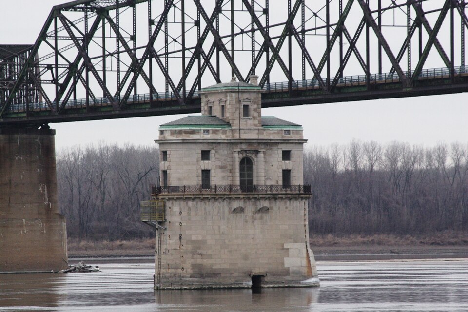
Photograph of Chain of Rocks Bridge
Photograph by Rklawton at English Wikipedia, CC BY-SA 3.0. Via Wikimedia Commons.

Chain of Rocks Bridge

Listed on the National Register of Historic Places in 2006.

From the record

“The Chain of Rocks Bridge spans the Mississippi River on the north edge of St. The eastern end of the bridge is on Chouteau Island, while the western end is on the Missouri shoreline.”

Wikipedia article Chain of Rocks Bridge, CC BY-SA 4.0.

One of 40 National Register listings published here for Madison County · listed in 2006 · category: Structure.

Sources: the Wikipedia article · the case file at the National Archives · the National Register database, National Park Service


The listing

  • Address. West Chain of Rocks Rd., Madison, 62048
  • When was it listed? December 2006
  • Category. structure
  • Also known as. Route 66 through Illinois MPS
  • Township. Chouteau township
  • National Register reference number. 06001091 - the number the National Park Service assigned this property when it was listed, and the key its nomination file is catalogued under at the National Archives.

The ground it stands on

26 words

This property stands in Chouteau Township. Centennial History of Madison County, Illinois, and Its People, 1812 to 1912, published 1912 gives that township a chapter of its own.

The chapter covers natural features, early settlement, early land claims entered, pioneer hardships, pleasures and dangers, education and religion, first mill and store.

Machine-read from a century-old scan, so expect the errors a machine makes: misspelled names, dropped words, stray characters.

Read the whole chapter on Chouteau Township - 26 words on its settlement, mills, schools and churches.

Mines and quarries near this property

5 within 5 miles

Regional context, not property-specific evidence. The federal mineral resources record lists 5 workings within 5 miles of Chain of Rocks Bridge: 4 past producers, 1 producer. 1 still produces. What was taken out: Stone, Crushed/Broken, Clay. Distance is straight-line from the map coordinates, so a quarry counted here may appear on a neighbouring settlement's page as well.

Where SiteCommodity StatusRecorded
Prospect Hill Cement PlantStone, Crushed/Broken, ClayProducer
Bemmey QuarryStone, Crushed/BrokenPast Producer
Emmerick QuarryStone, Crushed/BrokenPast Producer
Unknown - LsStone, Crushed/BrokenPast Producer

Every working recorded in Madison County

Storms near this property

25 since 1996

Regional context, not property-specific evidence. The National Weather Service names Madison, the town this property stands in, in 25 storm reports between 1996 and 2025: 12 thunderstorm wind, 11 hail, 1 flash flood, 1 tornado. No death or injury is recorded in these reports. Each account below is quoted exactly as the forecast office filed it, from the NOAA Storm Events Database, and each date opens the federal record of that event.

WhenEvent Place namedHarm What the report says
June 2022Thunderstorm WindMadison$10,000Thunderstorm winds blew a large tree down onto an unoccupied car in Granite City, causing major damage.
June 2008Flash FloodMadison$1,000Two to three inches of rain fell in a short amount of time over Madison county. Numerous secondary roads were flooded including some in the Granite City and Illinois Route 162 in Maryville. In Maryville, 3 people had to be rescued from a vehicle that had slid off the road and into a steep drainage ditch, which had overflowed and was flooding Illinois Route 162 in that location. None of the people from the car were injured.
May 2025Tornado (EF1)Madison-After crossing from St. Louis City, the tornado weakened. It caused EF-1 structural and tree damage in Granite City and Pontoon Beach before dissipating near Southern Illinois University - Edwardsville.
July 2023Thunderstorm WindMadison-Widespread wind damage across Madison County. Numerous trees, tree limbs and power lines were blown down. A couple of power poles were snapped off as well. In Madison, a small market sustained moderate roof damage. In Collinsville, the false roof of a building that covered up the A/C units was blown off and tossed onto Route 66 below. Also, a nearby Catholic school gymnasium sustained moderate roof damage. The tree damage was reported in Madison, Granite City, Roxana, Collinsville, Edwardsville, Glen Carbon, Maryville, Troy and Marine.
July 2023Thunderstorm WindMadison-Thunderstorm winds blew down numerous large tree limbs in Granite City and Collinsville.
June 2019Thunderstorm WindMadison-Thunderstorm winds blew down a large tree in Granite City and numerous large tree limbs around Horseshoe Lake.
May 2017Thunderstorm WindMadison-Thunderstorm winds blew down several large tree limbs and power lines around town.
April 2014HailMadison-A large swath of hail fell across Madison County from Granite City to the Glen Carbon area.
April 2012HailMadison-There were numerous reports of large hail across Granite City. The largest hail stones were tennis ball size.
April 2011HailMadison-Numerous repprts of golfball sized hail were reported over Granite City.
May 2011Thunderstorm WindMadison-Thunderstorm winds caused minor damage to a chimney. Also, part of the roof of a building was blown off near the intersection of 23rd Street and Washington Avenue. Several large trees were blown down around town.
August 2010Thunderstorm WindMadison-Thunderstorm winds blew down several large trees and many large tree limbs.
June 1997HailMadison-Skywarn spotters reported golfball size hail.
March 2024HailMadison-no account filed
July 2023HailMadison-no account filed
July 2021Thunderstorm WindMadison-no account filed
May 2018HailMadison-no account filed
October 2017HailMadison-no account filed
April 2011HailMadison-no account filed
May 2011HailMadison-no account filed
May 2007HailMadison-no account filed
August 2005Thunderstorm WindMadison-no account filed
September 2000Thunderstorm WindMadison-no account filed
August 2000Thunderstorm WindMadison-no account filed
October 1996Thunderstorm WindMadison-no account filed

Every storm recorded in Madison County

Map coverage status

No historic map-sheet match is published for this property yet. That does not mean no map exists. This record needs a coordinate-quality review before it can be joined to a sheet boundary. Browse the county's mapped places while that work is pending.

Listed places nearby

2 within 8 miles

Other National Register properties close enough to walk or drive between, ordered by distance from this one. Both positions come from the same geocoding pass that matched these properties to their map sheets.

Photograph PropertyDistance Listed
Granite City YMCA4.2 miles2017
Emmert-Zippel House4.5 miles1996

Sources for this property

National Archives recordThe nomination case file for reference 06001091 in Record Group 79.
Wikipedia articleCommunity-written account of this property, licensed CC BY-SA.
Madison CountyAll 40 listed properties in this county.

Provenance

  • Listing record. National Park Service National Register of Historic Places, listed-properties dataset, current to 2026-05-22.
  • Map join. Address geocoded through the United States Census geocoder, then tested against the published boundary of every sheet in the USGS Historical Topographic Map Collection.
  • How this page is made. Listing fields come from federal records; map-sheet coverage is a labelled coordinate-to-boundary calculation, not a source-field claim.
  • Mines and quarries. USGS Mineral Resources Data System (MRDS) https://mrdata.usgs.gov/mrds/ A work of the United States government, no copyright under 17 U.S.C. 105.
  • Storms. NOAA National Centers for Environmental Information, Storm Events Database https://www.ncei.noaa.gov/stormevents/ A work of the United States government, no copyright under 17 U.S.C. 105. Narratives are quoted verbatim from the National Weather Service report and are not edited or summarised.