
BlockBefore
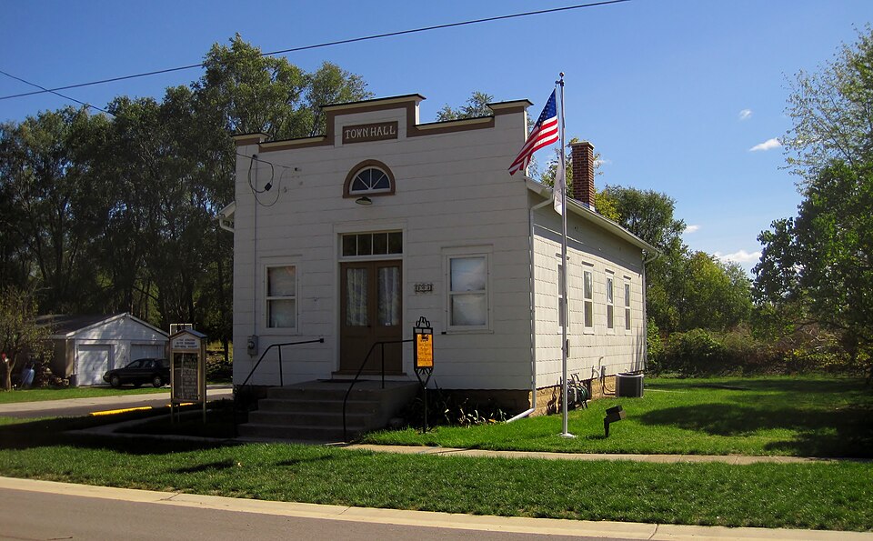
Photograph of Village of Davis Junction Town Hall
Photograph by Teemu08, CC BY-SA 3.0. Via Wikimedia Commons.

Village of Davis Junction Town Hall

Listed on the National Register of Historic Places in 2008.

From the record

“The Village of Davis Junction Town Hall is a historic building in Davis Junction, Illinois, United States. It is associated with the administration of Scott Township and is the only municipal building left from the early history of Davis Junction.”

Wikipedia article Village of Davis Junction Town Hall, CC BY-SA 4.0.

One of 29 National Register listings published here for Ogle County · listed in 2008 · category: Building.

Sources: the Wikipedia article · the case file at the National Archives · the National Register database, National Park Service
The listing

  • What is counted as historic. The nomination lists 1 building as contributing to the listing.
  • Address. 202 Pacific Ave., Davis Junction, 61020
  • When was it listed? June 2008
  • Category. building
  • Township. Scott township
  • National Register reference number. 08000504 - the number the National Park Service assigned this property when it was listed, and the key its nomination file is catalogued under at the National Archives.

The ground it stands on

6,769 words

The chapter on Scott Township in The History of Ogle County, Illinois, Containing a History of the County, Its Cities, Towns, Etc., a Biographical Directory of Its Citizens, War Record of Its Volunteers in the Late Rebellion, General and Local Statistics ... History of the Northwest, History of Illinois ... Etc, published 1878 names Davis Junction. This is what it says, exactly as the scans read.

BI.ACKMAX JL. W. Farmer; Sec. 13 ; P. O. Davis Junction ; born in Genesee Co., N. Y., in 1846; married Olive Stevens in 1867; she was born in Chemung Co., N. Y., in 1844 ; have one child, Henry W., born Feb. 3, 1871 ; came to this Co. in 1858 and settled in Monroe Tp. with his father, Walter Blackman, an old settler; in 1861 he settled on his present estate, where he has since resided.

Passage source: The History of Ogle County, Illinois, Containing a History of the County, Its Cities, Towns, Etc., a Biographical Directory of Its Citizens, War Record of Its Volunteers in the Late Rebellion, General and Local Statistics ... History of the Northwest, History of Illinois ... Etc, published 1878.

BRACEi P. Hardware Merchant ; Davis Junction; born in Schuyler Co., N. Y., July 29, 1835 ; came to this state in 1860, and settled in Rochelle, where he was employed in the hardware business about two years, when he removed to Iowa and engaged in farming, returning to Rochelle after two years residence in that state ; in 1875 he came to this village and settled in business; has a fine stock of hardware, and is prominently known and identified with the interests of the town.

Passage source: The History of Ogle County, Illinois, Containing a History of the County, Its Cities, Towns, Etc., a Biographical Directory of Its Citizens, War Record of Its Volunteers in the Late Rebellion, General and Local Statistics ... History of the Northwest, History of Illinois ... Etc, published 1878.

Machine-read from a century-old scan, so expect the errors a machine makes: misspelled names, dropped words, stray characters.

Read the whole chapter on Scott Township - 6,769 words on its settlement, mills, schools and churches.

Mines and quarries near this property

7 within 5 miles

Regional context, not property-specific evidence. The federal mineral resources record lists 7 workings within 5 miles of Village of Davis Junction Town Hall: 7 past producers. None of them still produces. What was taken out: Stone, Crushed/Broken. Distance is straight-line from the map coordinates, so a quarry counted here may appear on a neighbouring settlement's page as well.

Where SiteCommodity StatusRecorded
Dummer QuarryStone, Crushed/BrokenPast Producer
Larsons QuarryStone, Crushed/BrokenPast Producer
Lumpkin QuarryStone, Crushed/BrokenPast Producer
Pagel PitStone, Crushed/BrokenPast Producer
Unnamed Limestone QuarryStone, Crushed/BrokenPast Producer
Winquist Qry.Rein, Schultz & DahlStone, Crushed/BrokenPast Producer

Every working recorded in Ogle County

Storms near this property

8 since 2016

Regional context, not property-specific evidence. The National Weather Service names Davis Junction, the town this property stands in, in 8 storm reports between 2016 and 2025: 5 thunderstorm wind, 2 hail, 1 tornado. No death or injury is recorded in these reports. Each account below is quoted exactly as the forecast office filed it, from the NOAA Storm Events Database, and each date opens the federal record of that event.

WhenEvent Place namedHarm What the report says
May 2025Thunderstorm WindDavis Junction-Trees were snapped causing damage to property.
June 2025Thunderstorm WindDavis Junction-A large tree was down and blocking IL-72 in Davis Junction. Another tree was reported down on power lines.
July 2024Tornado (EF0)Davis Junction-A tornado with estimated peak winds of 80 mph touched down northwest of the intersection of Moulton Road and Route 72 and moved east through Davis Junction producing tree damage. The tornado ended east of Davis Junction and just north of Route 72.
August 2022Thunderstorm WindDavis Junction-Photos showed large live trees that were mostly uprooted. A few large tree limbs were also blown down.
August 2021Thunderstorm WindDavis Junction-A wind gust to 60 mph was measured.
June 2016Thunderstorm WindDavis Junction-Several four to six inch diameter tree limbs down near Friday Rd and Edson Rd. Time approximated from radar.
April 2023HailDavis Junction-no account filed
April 2022HailDavis Junction-no account filed

Every storm recorded in Ogle County

Map coverage status

No historic map-sheet match is published for this property yet. That does not mean no map exists. This record needs a coordinate-quality review before it can be joined to a sheet boundary. Browse the county's mapped places while that work is pending.

Listed places nearby

1 within 8 miles

Other National Register properties close enough to walk or drive between, ordered by distance from this one. Both positions come from the same geocoding pass that matched these properties to their map sheets.

Photograph PropertyDistance Listed
Stillman's Run Battle Site4.0 miles1983

Sources for this property

National Archives recordThe nomination case file for reference 08000504 in Record Group 79.
Wikipedia articleCommunity-written account of this property, licensed CC BY-SA.
Ogle CountyAll 29 listed properties in this county.

Provenance

  • Listing record. National Park Service National Register of Historic Places, listed-properties dataset, current to 2026-05-22.
  • Map join. Address geocoded through the United States Census geocoder, then tested against the published boundary of every sheet in the USGS Historical Topographic Map Collection.
  • How this page is made. Listing fields come from federal records; map-sheet coverage is a labelled coordinate-to-boundary calculation, not a source-field claim.
  • Mines and quarries. USGS Mineral Resources Data System (MRDS) https://mrdata.usgs.gov/mrds/ A work of the United States government, no copyright under 17 U.S.C. 105.
  • Storms. NOAA National Centers for Environmental Information, Storm Events Database https://www.ncei.noaa.gov/stormevents/ A work of the United States government, no copyright under 17 U.S.C. 105. Narratives are quoted verbatim from the National Weather Service report and are not edited or summarised.