BlockBefore
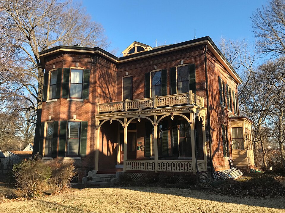
Photograph of Tiedemann House
Photograph by ErnstTiedemann, CC BY-SA 4.0. Via Wikimedia Commons.

Tiedemann House

Listed on the National Register of Historic Places in 2020.

From the record

“The Tiedemann House is a historic house at 212 W. The house was built in 1884 for Ernst Tiedemann, a local merchant and a member of the city's board of trustees.”

Wikipedia article Tiedemann House, CC BY-SA 4.0.

One of 27 National Register listings published here for St. Clair County · listed in 2020 · category: Building.

Sources: the Wikipedia article · the National Register database, National Park Service

The listing

  • What is counted as historic. The nomination lists 1 building, 1 structure as contributing to the listing.
  • Address. 212 West Washington St., O'Fallon, 62269
  • When was it listed? May 2020
  • Category. building
  • Township. O'Fallon township
  • National Register reference number. 100005233 - assigned by the National Park Service when the property was listed.

The ground it stands on

1,223 words

The chapter on O'Fallon Township in History of St. Clair County, Illinois. With Illustrations ... and Biographical Sketches of Some of Its Prominent Men and Pioneers, published 1881 names O'Fallon. This is what it says, exactly as the scans read.

Lodges. - The Royal Templars of Temperance was organized in February 1880. The Independent Order of Good Templers in February, 1881. The O'Fallon Lodge, No. 576, A F. and A. M., was chartered Oct. 6, 1868. Treu Bund, W. O. T. B., was organized May 6, 1871. The German Lodge No. 463, L O. O. F., organized in 1872. The 0 Fallon Lodge No. 431, I. 0. O. F., was chartered in 1869. St. Clair Lodge, K. of P. No. 40, chartered in 1875. German Lodge, K. of H. No. 878, chartered February 4, 1878. They are all well attended, and have a good membership.

Passage source: History of St. Clair County, Illinois. With Illustrations ... and Biographical Sketches of Some of Its Prominent Men and Pioneers, published 1881.

There are also two more coal mines in this precinct, east of O'Fallon, the Van Court mine, and the Nicholas mine. The former was sunk in 1863 by Sharp and Thompson. It is now owned by B. J. Van Court, and operated by Savitz Brothers, of St. Louis. The mine is 207 feet deep, with a seven foot vein. The Nicholas mine was sunk about 1870, by Nicholas and McCoy. It is now owned and operated by Joseph Morris. The shaft is 212 feet deep, and the vein the same thickness of the above.

Passage source: History of St. Clair County, Illinois. With Illustrations ... and Biographical Sketches of Some of Its Prominent Men and Pioneers, published 1881.

Machine-read from a century-old scan, so expect the errors a machine makes: misspelled names, dropped words, stray characters.

Read the whole chapter on O'Fallon Township - 1,223 words on its settlement, mills, schools and churches.

Mines and quarries near this property

3 within 5 miles

Regional context, not property-specific evidence. The federal mineral resources record lists 3 workings within 5 miles of Tiedemann House: 1 past producer, 1 prospect, 1 occurrence. None of them still produces. What was taken out: Clay, Stone, Crushed/Broken. Distance is straight-line from the map coordinates, so a quarry counted here may appear on a neighbouring settlement's page as well.

Where SiteCommodity StatusRecorded
Limestone ProspectStone, Crushed/BrokenOccurrence
Hill Brick Co. Shale PitClayPast Producer
Little Canteen Shale ExposureClayProspect

Every working recorded in St. Clair County

Storms near this property

31 since 1995

Regional context, not property-specific evidence. The National Weather Service names O'Fallon, the town this property stands in, in 31 storm reports between 1995 and 2025: 17 thunderstorm wind, 13 hail, 1 tornado. The reports record 2 injuries. Each account below is quoted exactly as the forecast office filed it, from the NOAA Storm Events Database, and each date opens the federal record of that event.

WhenEvent Place namedHarm What the report says
March 2025Thunderstorm WindO Fallon2 hurt, $150,000Thunderstorm winds caused a home to collapse with two elderly residents inside.
March 2025Tornado (EF1)O Fallon$150,000At approximately 10:28 PM a tornado began in the northeastern outskirts of O'Fallon, IL where it caused damage to multiple mobile homes, single family homes, outbuildings, and trees along its track northeast. The tornado then passed into southern Madison County. In Madison County the tornado was rated EF-1 with a path length of 6.75 miles and a maximum path width of 770 yards. In St. Clair County the tornado was rated EF-1 with a path length of 5.9 miles and a maximum path width of 450 yards.
May 1995Thunderstorm WindO'Fallon$800Numerous power lines and large trees were knocked down across the county.
March 2025HailO Fallon-Wind driven hail caused extensive damage to west facing homes and buildings.
March 2025Thunderstorm WindO Fallon-Thunderstorm winds snapped a large tree which fell onto a house and its deck.
March 2025Thunderstorm WindO Fallon-Thunderstorm wind driven hail destroyed the siding and windows on numerous homes spanning entire neighborhoods in O'Fallon.
June 2013Thunderstorm WindO Fallon-Thunderstorm winds blew down a 6 inch diameter tree.
July 2009Thunderstorm WindO Fallon-Several trees and power lines were blown down. Also, one house sustained minor siding damage.
July 2006Thunderstorm WindO Fallon-Several large trees and tree limbs were blown down.
July 2006Thunderstorm WindO Fallon-Several large tree limbs were blown down.
March 2025HailO Fallon-no account filed
August 2019HailO Fallon-no account filed
May 2018HailO Fallon-no account filed
May 2013HailO Fallon-no account filed
March 2012HailO Fallon-no account filed
May 2010HailO Fallon-no account filed
June 2009HailO Fallon-no account filed
June 2005Thunderstorm WindO Fallon-no account filed
May 2004HailO Fallon-no account filed
July 2004Thunderstorm WindO Fallon-no account filed
June 2003Thunderstorm WindO Fallon-no account filed
July 2002Thunderstorm WindO Fallon-no account filed
July 2001Thunderstorm WindO Fallon-no account filed
August 2000Thunderstorm WindO Fallon-no account filed
February 1999HailO Fallon-no account filed
May 1998Thunderstorm WindO Fallon-no account filed
April 1996HailO Fallon-no account filed

Every storm recorded in St. Clair County

Map coverage status

No historic map-sheet match is published for this property yet. That does not mean no map exists. This record needs a coordinate-quality review before it can be joined to a sheet boundary. Browse the county's mapped places while that work is pending.

Listed places nearby

6 within 8 miles

Other National Register properties close enough to walk or drive between, ordered by distance from this one. Both positions come from the same geocoding pass that matched these properties to their map sheets.

Photograph PropertyDistance Listed
Scott Field Historic District4.7 miles1994
Lebanon Historic District5.4 miles1978
Mermaid House Hotel5.8 miles1975
Gustave Koerner House6.6 miles2004
Belleville Historic District6.7 miles1976
Blair Historic District6.7 miles2015

Sources for this property

National Archives recordThe nomination case file for reference 100005233 in Record Group 79.
Wikipedia articleCommunity-written account of this property, licensed CC BY-SA.
St. Clair CountyAll 27 listed properties in this county.

Provenance

  • Listing record. National Park Service National Register of Historic Places, listed-properties dataset, current to 2026-05-22.
  • Map join. Address geocoded through the United States Census geocoder, then tested against the published boundary of every sheet in the USGS Historical Topographic Map Collection.
  • How this page is made. Listing fields come from federal records; map-sheet coverage is a labelled coordinate-to-boundary calculation, not a source-field claim.
  • Mines and quarries. USGS Mineral Resources Data System (MRDS) https://mrdata.usgs.gov/mrds/ A work of the United States government, no copyright under 17 U.S.C. 105.
  • Storms. NOAA National Centers for Environmental Information, Storm Events Database https://www.ncei.noaa.gov/stormevents/ A work of the United States government, no copyright under 17 U.S.C. 105. Narratives are quoted verbatim from the National Weather Service report and are not edited or summarised.