 Block
From the record
One of 40 National Register listings published here for Madison County · listed in 2023 · category: Building.
Sources: the National Register database, National Park Service
Listed on the National Register of Historic Places in 2023.
One of 40 National Register listings published here for Madison County · listed in 2023 · category: Building.
Sources: the National Register database, National Park Service
The chapter on Collinsville Township in History of Madison County, Illinois ... With Biographical Sketches .., published 1882 names Collinsville. This is what it says, exactly as the scans read.
The original town plat was laid out by the representatives of Wm. B. Collins, deceased, Joseph L. Darrow and Horace Look. It constituted a part of the N. E. i of thirtythree, jind a part of the X. W. i of section thirty-four, of three-eight or Collinsville township. The plat was recorded in the office of county clerk May 12, 1837. Since this date there have been seventeen additions made to the plat.
Passage source: History of Madison County, Illinois ... With Biographical Sketches .., published 1882.
The first settler on the present site of Collinsville was John A. Cook, who entered land,, erected a log cabin, and made some improvements in the eastern part of section thirty four, about 1816. "In 1817 three brothers, Augustus, Anson and Michael Collins, from Litchfield, Connecticut, purchased the premises of Mr. Cook, and immediately commenced improvements. They soon erected a distillery, of logs, with two s' ills - one of thirty gallons' and the other of sixty gallons' capacity - a frame store-house, a large, double-decked ox-grist and saw mill, cooper, blacksmith, wagon and carpenter shops, tan yard, and several dwellings. Thus was laid the foundation of the present city of Collinsville. To this place these brothers first gave the name Unionville, which was subsequently changed to its present name." The following letter from the pen of the late Rev. Thomas Lipjiincott, gives a good description of the place at the time of his visit :
Passage source: History of Madison County, Illinois ... With Biographical Sketches .., published 1882.
Machine-read from a century-old scan, so expect the errors a machine makes: misspelled names, dropped words, stray characters.
Read the whole chapter on Collinsville Township - 7,805 words on its settlement, mills, schools and churches.
Regional context, not property-specific evidence. The federal wildfire occurrence database lists 4 fires within 5 miles of Collinsville Township High School between 2008 and 2011, burning about 2 acres in total. None started naturally. None was recorded as arson. Distance is straight-line from the map coordinates, so a fire counted here may appear on a neighbouring settlement's page as well.
| Reported cause | Fires |
|---|---|
| Missing data/not specified/undetermined | 3 |
| Debris and open burning | 1 |
The most recent of them, most recent first, with the day each was reported and the service that recorded it.
| Date | Cause | Size | Reported by | Name on the report |
|---|---|---|---|---|
| 10 September 2008 | Debris and open burning | under an acre | Illinois Division of Forestry Resources | 10 BARCLAY |
| 23 March 2011 | Missing data/not specified/undetermined | under an acre | Illinois Division of Forestry Resources | CAMPMEYER |
| 27 January 2008 | Missing data/not specified/undetermined | under an acre | Illinois Division of Forestry Resources | HADFIELD |
| 26 January 2008 | Missing data/not specified/undetermined | 1.0 acres | Illinois Division of Forestry Resources | AGIDON |
Regional context, not property-specific evidence. The federal mineral resources record lists 4 workings within 5 miles of Collinsville Township High School: 2 past producers, 1 occurrence, 1 prospect. None of them still produces. What was taken out: Fire Clay (Refractory), Aluminum, Iron, Silica, Titanium, Stone, Sand and Gravel, Construction. Distance is straight-line from the map coordinates, so a quarry counted here may appear on a neighbouring settlement's page as well.
| Where | Site | Commodity | Status | Recorded |
|---|---|---|---|---|
| Barker Dredge | Sand and Gravel, Construction | Past Producer | ||
| Collinsville Pit | Stone | Past Producer | ||
| Madison County Fireclay | Fire Clay (Refractory) | Occurrence | ||
| Madison County Fireclay | Aluminum, Iron, Silica, Titanium | Prospect |
Regional context, not property-specific evidence. The National Weather Service names Collinsville, the town this property stands in, in 44 storm reports between 1996 and 2026: 23 hail, 18 thunderstorm wind, 2 lightning, 1 tornado. The reports record 1 injury. Each account below is quoted exactly as the forecast office filed it, from the NOAA Storm Events Database, and each date opens the federal record of that event.
| When | Event | Place named | Harm | What the report says |
|---|---|---|---|---|
| August 1996 | Lightning | Collinsville | 1 hurt | no account filed |
| May 1996 | Thunderstorm Wind | Collinsville | $15,000 | no account filed |
| March 2026 | Thunderstorm Wind | Collinsville | - | A TV meteorologist noted several gusts over 60 mph in his station's Storm Runner vehicle. |
| April 2023 | Tornado (EFU) | Collinsville | - | A tornado briefly touched down just to the west of Collinsville, IL. The only evidence of this tornado was a video provided via local media. Duration was likely less than 1 minute, no damage or injuries. The tornado was rated EFU with an estimated path length of 0.16 miles and an estimated path width of 25 yards. |
| April 2019 | Hail | Collinsville | - | Another severe storm moved through the southern half of Madison County dropping large hail between Collinsville and Troy. The largest hail stones reported were 2 inches in diameter. |
| May 2018 | Thunderstorm Wind | Collinsville | - | Several large tree limbs were blown down onto a house and car causing moderate damage. |
| June 2018 | Thunderstorm Wind | Collinsville | - | Thunderstorm winds blew down several trees throughout Collinsville. The worst damage occurred near St. Johns Cemetery where several large trees and headstones were toppled. |
| February 2017 | Thunderstorm Wind | Collinsville | - | Thunderstorm winds blew down several trees and power lines in Collinsville and just south of Pontoon Beach. One house sustained siding damage from the winds. |
| February 2017 | Hail | Collinsville | - | A wide swath of large hail, up to two inches in diameter, fell across Madison County from the Collinsville/Pontoon Beach area northeastward through Maryville, Glen Carbon, Edwardsville, Troy and Marine. |
| June 2015 | Thunderstorm Wind | Collinsville | - | Thunderstorm winds snapped an 18 inch diameter ash tree about 10 feet up from the base. |
| April 2014 | Thunderstorm Wind | Collinsville | - | Thunderstorm winds blew down a tree across a road two miles south of St. Jacob. |
| August 2014 | Thunderstorm Wind | Collinsville | - | Thunderstorm winds blew down a large tree onto a power line. |
| April 2011 | Thunderstorm Wind | Collinsville | - | Thunderstorm winds blew down a two foot diameter tree limb as well as numerous smaller limbs. |
| May 2008 | Hail | Collinsville | - | Amateur radio spotters reported nickel size hail. |
| May 2008 | Hail | Collinsville | - | A trained spotter reported 1 inch hail. |
| May 2007 | Hail | Collinsville | - | Storm spotters reported hail in Collinsville ranging from pea size to 1 inch. |
| April 2006 | Hail | Collinsville | - | The Collinsville Police reported nickel size hail. |
| July 2006 | Thunderstorm Wind | Collinsville | - | Numerous large trees, tree limbs and power lines were blown down. Several of the trees caused minor to moderate roof damage. |
| July 2004 | Lightning | Collinsville | - | A lightning strike started several fires at a home in Collinsville. The home suffered extensive damage. |
| July 2004 | Thunderstorm Wind | Collinsville | - | The local fire department reported numerous large tree limbs and power lines down across town. |
| June 2001 | Thunderstorm Wind | Collinsville | - | Thunderstorm wind gusts caused scattered damage across Collinsville. Trees and power lines were downed leaving about 2500 customers without power. |
| July 2001 | Thunderstorm Wind | Collinsville | - | Local law enforcement reported numerous trees and power lines down. |
| June 2000 | Thunderstorm Wind | Collinsville | - | The Collinsville Police reported a large tree down blocking a street on the east side of town. |
| October 2000 | Hail | Collinsville | - | The Collinsville Police reported 3/4 inch hail on the south side side of town. |
| March 2025 | Hail | Collinsville | - | no account filed |
| March 2021 | Hail | Collinsville | - | no account filed |
| May 2016 | Hail | Collinsville | - | no account filed |
| April 2014 | Hail | Collinsville | - | no account filed |
| September 2012 | Hail | Collinsville | - | no account filed |
| January 2012 | Hail | Collinsville | - | no account filed |
| April 2011 | Hail | Collinsville | - | no account filed |
| June 2009 | Hail | Collinsville | - | no account filed |
| January 2008 | Hail | Collinsville | - | no account filed |
| February 2006 | Hail | Collinsville | - | no account filed |
| February 2006 | Hail | Collinsville | - | no account filed |
| July 2006 | Hail | Collinsville | - | no account filed |
| August 2005 | Thunderstorm Wind | Collinsville | - | no account filed |
| May 2004 | Hail | Collinsville | - | no account filed |
| May 2004 | Hail | Collinsville | - | no account filed |
| May 2004 | Hail | Collinsville | - | no account filed |
| August 2000 | Thunderstorm Wind | Collinsville | - | no account filed |
| August 2000 | Thunderstorm Wind | Collinsville | - | no account filed |
| June 1998 | Thunderstorm Wind | Collinsville | - | no account filed |
| April 1997 | Hail | Collinsville | - | no account filed |
No historic map-sheet match is published for this property yet. That does not mean no map exists. This record needs a coordinate-quality review before it can be joined to a sheet boundary. Browse the county's mapped places while that work is pending.
Other National Register properties close enough to walk or drive between, ordered by distance from this one. Both positions come from the same geocoding pass that matched these properties to their map sheets.
| Photograph | Property | Distance | Listed |
|---|---|---|---|
 | Brooks Catsup Bottle Water Tower | 0.5 miles | 2002 |
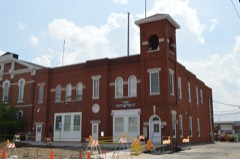 | Collinsville City Hall and Fire Station | 0.9 miles | 2004 |
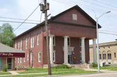 | Collinsville Masonic Temple Lodge #712 A.F. & A.M. | 0.9 miles | 2005 |
 | State Bank Building | 1.0 miles | 2010 |
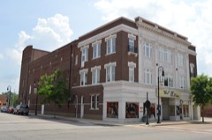 | Miners Institute Building | 1.1 miles | 1985 |
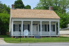 | Daniel Dove Collins House | 1.2 miles | 2002 |
| National Archives record | The nomination case file for reference 100009253 in Record Group 79. |
| Madison County | All 40 listed properties in this county. |