
BlockBefore
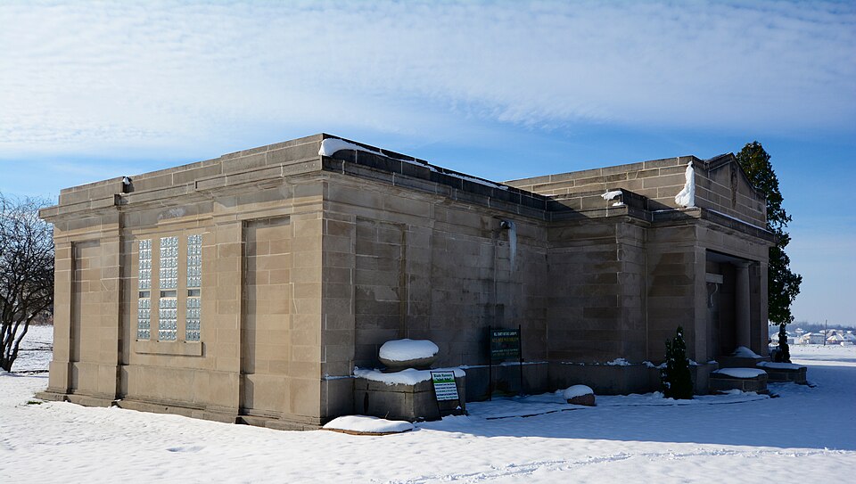
Photograph of Beecher Mausoleum
Photograph by Boscophotos, CC BY-SA 3.0. Via Wikimedia Commons.

Beecher Mausoleum

Built in 1913 (Neoclassical architecture). Listed on the National Register of Historic Places in 2013.

From the record

“The Beecher Mausoleum is a community mausoleum located at the junction of Illinois Route 1 and Horner Lane in Washington Township, Will County, Illinois, southeast of the village of Beecher. The mausoleum was built in 1913-14, making it an early example of a community mausoleum.”

Wikipedia article Beecher Mausoleum, CC BY-SA 4.0.

One of 38 National Register listings published here for Will County · listed in 2013 · category: Building · built in 1913, Neoclassical architecture.

Sources: the Wikipedia article · the National Register database, National Park Service

The listing

  • What is counted as historic. The nomination lists 1 building as contributing to the listing.
  • Address. Jct. of IL 1 & Horner Ln., Beecher, 60401
  • When was it listed? September 2013
  • Category. building
  • Township. Washington township
  • When was it built? 1913
  • Architectural style. Neoclassical architecture
  • National Register reference number. 13000714 - assigned by the National Park Service when the property was listed.

Storms near this property

33 since 1994

Regional context, not property-specific evidence. The National Weather Service names Beecher, the town this property stands in, in 33 storm reports between 1994 and 2026: 18 thunderstorm wind, 6 hail, 3 tornado, 2 flood. No death or injury is recorded in these reports. Each account below is quoted exactly as the forecast office filed it, from the NOAA Storm Events Database, and each date opens the federal record of that event.

WhenEvent Place namedHarm What the report says
May 2011LightningBeecher$300,000A house near the intersection of South Ashland Avenue and Peotone-Beecher Road caught on fire after being struck by lightning. The roof and second story were completely destroyed by the fire and the first floor was destroyed by water damage.
September 2014Thunderstorm WindBeecher$55,000A large tree was blown down damaging a home. Three power lines were blown down two miles south of Beecher.
April 1994Tornado (F1)Beecher$50,000Two small tornadoes touched down producing parallel paths about 0.50 to 1 mile apart. The first tornado touched down southeast of Beecher damaging a house roof, grain bins and other farm buildings. A few trees and limbs were also damaged and one power pole was pushed partly over. The tornado lifted just west of the Indiana state line. Another tornado touched down about 0.50 mile northwest of where the first tornado lifted in eastern Will County. It crossed the state line into Lake County Indiana 5 miles east of Beecher. On the Illinois side the tornado blew down tree limbs and knocked down an antenna. One house had its roof taken off at the state line. On the Indiana side, several farm buildings were damaged and a row of pine trees was uprooted at another farm.
September 2007Thunderstorm WindBeecher$1,000At least five large trees were blown down, some fell onto power lines.
April 2026Thunderstorm WindBeecher-Power poles and trees were downed in Beecher. A fire was started when one branch fell onto a power line.
July 2024Thunderstorm WindBeecher-Multiple tree limbs were blown down in and near Beecher.
July 2024Thunderstorm WindBeecher-A large tree limb was snapped off of a tree.
August 2021Heavy RainBeecher-Rainfall of 3.76 inches was measured in 1 hour and 20 minutes.
June 2020Thunderstorm WindBeecher-A 25 to 30 foot tall tree was blown over onto a fence. Wind gusts were estimated to 65 mph.
June 2020Funnel CloudBeecher-A funnel cloud was reported in the vicinity of Beecher.
July 2019Heavy RainBeecher-Rainfall of 1.60 inches was measured in 25 minutes.
August 2019Thunderstorm WindBeecher-An old barn was pushed off its foundation and a silo was damaged.
August 2019Thunderstorm WindBeecher-Several large tree limbs were blown down. One large tree was snapped and a garage was damaged.
August 2019Thunderstorm WindBeecher-Several silos and associated equipment were blown over and damaged on W County Line Road. A large tree limb was blown down.
July 2018Thunderstorm WindBeecher-A one foot diameter tree, 20 to 30 feet tall, was uprooted along County Line Road.
June 2017Tornado (EF0)Beecher-A trained spotter recorded a video of a brief landspout near Beecher looking north from Route 1. No damage was reported.
June 2017Thunderstorm WindBeecher-Trees around 10 inches in diameter along with other tree limbs were blown down east of Beecher around a golf course.
May 2011HailBeecher-Up to golf ball size hail was reported near the town of Beecher. Specific reports include golf ball and half dollar size hail approximately one and two miles south of Beecher, respectively, on Illinois Route 1. Half dollar size hail was also reported near the intersection of Ashland Avenue and Peotone-Beecher Road.
June 2010Thunderstorm WindBeecher-Wind gusts were estimated to 70 mph.
June 2010Thunderstorm WindBeecher-A one foot diameter tree was blown down.
July 2007Thunderstorm WindBeecher-A four inch diameter tree was snapped off 4 feet above the ground.
April 2006FloodBeecher-Beecher Road closed due to flooding. Other roads under water.
May 2006Thunderstorm WindBeecher-Trees were blown down.
July 2006FloodBeecher-One foot of water covering Route 1, one mile south of Beecher. Peotone measured 2.02 inches of rainfall.
June 2005Thunderstorm WindBeecher-Numerous trees were blown down in the Racoon Grove Forest Preserve. At the Pheasant Lake Estates, a 6 inch tree was uprooted, a trailer was damaged, a shed was moved and leveled and a car port was blown down.
April 2004Tornado (F0)Beecher-A weak tornado pulled shingles off two mobile homes near the corner of 319th and Yates. There was minor roof damage to a barn.
May 2004HailBeecher-Reported at the intersection of Eagle Road and Western Road.
May 2004HailBeecher-Reported at Eagle Road and IL Route 1.
July 2016HailBeecher-no account filed
June 2013Thunderstorm WindBeecher-no account filed
July 2012HailBeecher-no account filed
May 2006HailBeecher-no account filed
August 2001Thunderstorm WindBeecher-no account filed

Every storm recorded in Will County

Map coverage status

No historic map-sheet match is published for this property yet. That does not mean no map exists. This record needs a coordinate-quality review before it can be joined to a sheet boundary. Browse the county's mapped places while that work is pending.

Listed places nearby

1 within 8 miles

Other National Register properties close enough to walk or drive between, ordered by distance from this one. Both positions come from the same geocoding pass that matched these properties to their map sheets.

Photograph PropertyDistance Listed
Joseph Ferris Perry House7.4 miles2022

Sources for this property

National Archives recordThe nomination case file for reference 13000714 in Record Group 79.
Wikipedia articleCommunity-written account of this property, licensed CC BY-SA.
Will CountyAll 38 listed properties in this county.

Provenance

  • Listing record. National Park Service National Register of Historic Places, listed-properties dataset, current to 2026-05-22.
  • Map join. Address geocoded through the United States Census geocoder, then tested against the published boundary of every sheet in the USGS Historical Topographic Map Collection.
  • How this page is made. Listing fields come from federal records; map-sheet coverage is a labelled coordinate-to-boundary calculation, not a source-field claim.
  • Storms. NOAA National Centers for Environmental Information, Storm Events Database https://www.ncei.noaa.gov/stormevents/ A work of the United States government, no copyright under 17 U.S.C. 105. Narratives are quoted verbatim from the National Weather Service report and are not edited or summarised.