BlockBefore
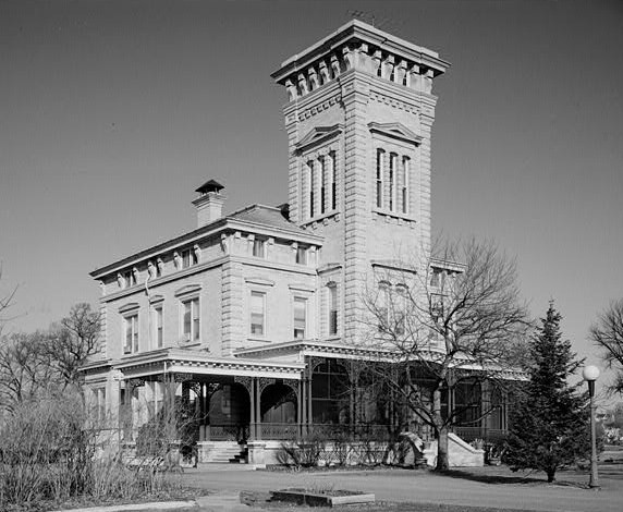
Photograph of Rock Island Arsenal
Photograph by Robert A, Ryan, J. Ceronia, and Bruce A. Harms, Photographers, Public domain. Via Wikimedia Commons.

Rock Island Arsenal

A National Historic Landmark. Built in 1862 (Greek Revival architecture). Listed on the National Register of Historic Places in 1969.

From the record

“The Rock Island Arsenal comprises 946 acres (383 ha) located on Arsenal Island, originally known as Rock Island, on the Mississippi River between the cities of Davenport, Iowa, and Rock Island, Illinois. It is home to the United States Army First Army Headquarters, and the United States Army Center of Excellence for Additive Manufacturing.”

Wikipedia article Rock Island Arsenal, CC BY-SA 4.0.

One of 29 National Register listings published here for Rock Island County · listed in 1969 · category: District · built in 1862, Greek Revival architecture · a National Historic Landmark.

Sources: the Wikipedia article · the case file at the National Archives · the National Register database, National Park Service


The listing

  • Address. Rock Island in Mississippi River, Rock Island, 61201
  • When was it listed? September 1969
  • Category. district
  • Township. Rock Island township
  • When was it built? 1862
  • Architectural style. Greek Revival architecture
  • National Register reference number. 69000057 - the number the National Park Service assigned this property when it was listed, and the key its nomination file is catalogued under at the National Archives.

The ground it stands on

19,359 words

The chapter on Rock Island Township in Historic Rock Island County; History of the Settlement of Rock Island County from the Earliest Known Period to the Present Time ... Embracing References of Importance, and Including a Biography of Rock Island County's Well-known Citizens, published 1908 names Rock Island. This is what it says, exactly as the scans read.

A history of the towns of Rock Island and Moline would apparently be similar and coincident to the history of the cities of Rock Island and Moline, the two towns being the corporate limits of the two cities. The date of the formation of these two townships is noted in Township Organization.

Passage source: Historic Rock Island County; History of the Settlement of Rock Island County from the Earliest Known Period to the Present Time ... Embracing References of Importance, and Including a Biography of Rock Island County's Well-known Citizens, published 1908.

The City of Rock Island was preceded by the Town of Farnhamsburg. the first settlement on this side of the river within the ])resent City limits. Here the first house was built by Colonel Davenport and Russell Farnham. partners in the Indian trade, in 1826. It stood near the landing from old Fort Armstrong, about a block south of the southern approach to the present railroad bridge over Sylvan Water, and on an elevated lime stone knoll. The county road from the east ran in front of it. and turned from the Moline road to the west of the Lemuel Andrews residence - now Honorable Ben T. Cable's residence - and down along where is now the Hurlington and ^lilwaukee Railroad tracks, until it reached Twenty-fom-th Street, where it met old Illinois Street, now Second Avenue. The house was a noted place in the early history of Rock Island County. Here the County Covernment was formed, the first elections held, and the first postoffice established; it was the seat of the Circuit and County Courts from 1833 to 1835. In the latter year, this original seat of justice of the county was sui^erseded by the Town of Stephenson, and a laid out in what is now the lower ])art of the City of Rock Lsland. It was laid out by the commissioners authorized by the Legislature to establish the seat of justice for Rock Island County, anil contained the old county grounds, with a ])ortion of the county buildings. There are still standing many of the earlier buildings erected by the pioneers and here were inaugurated man}' of the first institutions of Rock Island. Stephenson was the cradle of Rock Island, the nursery of much of that intellectual and social life which has since expanded into the laraor and intenser life of the cit\-.

Passage source: Historic Rock Island County; History of the Settlement of Rock Island County from the Earliest Known Period to the Present Time ... Embracing References of Importance, and Including a Biography of Rock Island County's Well-known Citizens, published 1908.

Machine-read from a century-old scan, so expect the errors a machine makes: misspelled names, dropped words, stray characters.

Read the whole chapter on Rock Island Township - 19,359 words on its settlement, mills, schools and churches.

Fires near this property

19 since 2006

Regional context, not property-specific evidence. The federal wildfire occurrence database lists 19 fires within 5 miles of Rock Island Arsenal between 2006 and 2019, burning about 20 acres in total. None started naturally. None was recorded as arson. Distance is straight-line from the map coordinates, so a fire counted here may appear on a neighbouring settlement's page as well.

Reported cause Fires
Missing data/not specified/undetermined10
Debris and open burning4
Smoking4
Power generation/transmission/distribution1

The most recent of them, most recent first, with the day each was reported and the service that recorded it.

DateCause SizeReported by Name on the report
23 September 2009Smokingunder an acreIllinois Division of Forestry ResourcesIDNR2
11 September 2009Debris and open burningunder an acreIllinois Division of Forestry ResourcesIDNR
16 August 2008Missing data/not specified/undetermined2.0 acresIllinois Division of Forestry ResourcesMM15
3 July 2010Missing data/not specified/undeterminedunder an acreIllinois Division of Forestry Resources528
24 July 2010Power generation/transmission/distributionunder an acreIllinois Division of Forestry ResourcesMID AMERICA
22 July 2008Missing data/not specified/undeterminedunder an acreIllinois Division of Forestry ResourcesPOLE
9 April 2019Debris and open burning2.0 acresIowa Department of Natural Resourcesnot named
3 April 2011Missing data/not specified/undetermined10 acresIowa Department of Natural ResourcesH AVE AND E 49, IA

Every fire recorded in Rock Island County

Mines and quarries near this property

6 within 5 miles

Regional context, not property-specific evidence. The federal mineral resources record lists 6 workings within 5 miles of Rock Island Arsenal: 3 past producers, 2 producers, 1 plant. 3 still produce. What was taken out: Stone, Crushed/Broken, Sand and Gravel, Construction. Distance is straight-line from the map coordinates, so a quarry counted here may appear on a neighbouring settlement's page as well.

Where SiteCommodity StatusRecorded
Big Island Plant #51 DredgeSand and Gravel, ConstructionProducer
Builders Sand and Gravel Co. DredgeSand and Gravel, ConstructionProducer
Allied Stone Plant #30Stone, Crushed/BrokenPlant
Bettendorf Stone Co. QuarryStone, Crushed/BrokenPast Producer
Rock Island City Eng.Stone, Crushed/BrokenPast Producer
U. S. Army EngineersStone, Crushed/BrokenPast Producer

Every working recorded in Rock Island County

Storms near this property

1 since 1994

Regional context, not property-specific evidence. The National Weather Service names Rock Island, the town this property stands in, in 1 storm report in 1994: 1 hail. No death or injury is recorded in these reports. Each account below is quoted exactly as the forecast office filed it, from the NOAA Storm Events Database, and each date opens the federal record of that event.

WhenEvent Place namedHarm What the report says
April 1994HailRock Island-On the evening of the 14th, and the early morning hours of the 15th, numerous thunderstorms moved across the Mississippi River bringing with them isolated wind and hail storms. Reports were received of 50 and 60 mph winds and three-quarter inch to one inch hail, but damage was minor. At 0145 CST lightning struck a tree in Reynolds, Illinois, followed by wind damage to metal shed. Shortly before 0200 CST, Port Byron, Illinois reported three-quarter inch to one inch hail.

Every storm recorded in Rock Island County

Map coverage status

No historic map-sheet match is published for this property yet. That does not mean no map exists. This record needs a coordinate-quality review before it can be joined to a sheet boundary. Browse the county's mapped places while that work is pending.

Listed places nearby

6 within 8 miles

Other National Register properties close enough to walk or drive between, ordered by distance from this one. Both positions come from the same geocoding pass that matched these properties to their map sheets.

Photograph PropertyDistance Listed
Rock Island Lines Passenger Station0.9 miles1982
Old Main, Augustana College0.9 miles1975
Rock Island National Cemetery1.0 miles1997
Lock and Dam No. 15 Historic District1.1 miles2004
Weyerhaeuser House1.2 miles1975
Skelly Service Station1.3 miles2024

Sources for this property

National Archives recordThe nomination case file for reference 69000057 in Record Group 79.
Wikipedia articleCommunity-written account of this property, licensed CC BY-SA.
Rock Island CountyAll 29 listed properties in this county.

Provenance

  • Listing record. National Park Service National Register of Historic Places, listed-properties dataset, current to 2026-05-22.
  • Map join. Address geocoded through the United States Census geocoder, then tested against the published boundary of every sheet in the USGS Historical Topographic Map Collection.
  • How this page is made. Listing fields come from federal records; map-sheet coverage is a labelled coordinate-to-boundary calculation, not a source-field claim.
  • Wildfire. Short, Karen C. 2022. Spatial wildfire occurrence data for the United States, 1992-2020 [FPA_FOD_20221014]. 6th Edition. Fort Collins, CO: Forest Service Research Data Archive. https://doi.org/10.2737/RDS-2013-0009.6 Collected with United States Government funding and usable without additional permissions or fees.
  • Mines and quarries. USGS Mineral Resources Data System (MRDS) https://mrdata.usgs.gov/mrds/ A work of the United States government, no copyright under 17 U.S.C. 105.
  • Storms. NOAA National Centers for Environmental Information, Storm Events Database https://www.ncei.noaa.gov/stormevents/ A work of the United States government, no copyright under 17 U.S.C. 105. Narratives are quoted verbatim from the National Weather Service report and are not edited or summarised.