
BlockBefore
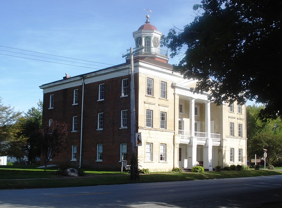
Photograph of Bishop Hill Colony
Photograph by Kepper66, CC BY-SA 3.0. Via Wikimedia Commons.

Colony Steeple Building

A National Historic Landmark. Built in 1846. Listed on the National Register of Historic Places in 1970.

From the record

“Bishop Hill Colony is a historic district in Bishop Hill, Illinois. Bishop Hill was the site of a utopian religious community which operated as a commune.”

Wikipedia article Bishop Hill Colony, CC BY-SA 4.0.

One of 16 National Register listings published here for Henry County · listed in 1970 · category: Building · built in 1846 · a National Historic Landmark.

Sources: the Wikipedia article · the case file at the National Archives · the National Register database, National Park Service
The listing

  • National Historic Landmark. The highest federal designation, held by about 2,600 places in the country against roughly 100,000 Register listings.
  • What is counted as historic. The nomination lists 35 buildingss, 6 sitess as contributing to the listing.
  • Still standing. The Park Service records this property as extant.
  • Address. Off US 34, Bishop Hill, 61419
  • When was it listed? April 1970
  • Category. building
  • Township. Weller township
  • When was it built? 1846
  • National Register reference number. 70000244 - the number the National Park Service assigned this property when it was listed, and the key its nomination file is catalogued under at the National Archives.

The ground it stands on

11,807 words

The chapter on Weller Township in History of Henry County, Illinois : It's Taxpayers and Voters; Containing Also, a Biographical Directory, a Condensed History of the State; Map of the County; a Business Directory...etc, published 1877 names Bishop Hill. This is what it says, exactly as the scans read.

ANDERSON HOKAN, Farmer, Sec. 16; P.O. Bishop Hill; born Sweden, Aug. 2, 1822; Rep; owns 200 acres of land, value $10,000; he lived in Sweden thirty-five years, and came to this country in 1857; came to this state, Henry Co. same year; has been here twenty years next July; held office School Director; married Mary Christian Johnson, Feb. 28, 1862; she was born Sweden, Dec. 15, 1832; have four children, three boys and one girl: Anna M.t John, Edwin, Alfred.

Passage source: History of Henry County, Illinois : It's Taxpayers and Voters; Containing Also, a Biographical Directory, a Condensed History of the State; Map of the County; a Business Directory...etc, published 1877.

ANDERSON LARS W. Harness-maker, Bishop Hill; born Sweden; Jan. 14, 1843; Dem; Lib; he lived in Sweden three years, and came to this country 1846, and came to this state and county, to Bishop Hill, with colony; has lived here thirty years; married Christine Swanson in June, 1868; she was born in Sweden, April 8, 1848; they have two children, sons.

Passage source: History of Henry County, Illinois : It's Taxpayers and Voters; Containing Also, a Biographical Directory, a Condensed History of the State; Map of the County; a Business Directory...etc, published 1877.

Machine-read from a century-old scan, so expect the errors a machine makes: misspelled names, dropped words, stray characters.

Read the whole chapter on Weller Township - 11,807 words on its settlement, mills, schools and churches.

Storms near this property

11 since 1996

Regional context, not property-specific evidence. The National Weather Service names Bishop Hill, the town this property stands in, in 11 storm reports between 1996 and 2025: 7 hail, 3 thunderstorm wind, 1 tornado. The reports record 4 injuries. Each account below is quoted exactly as the forecast office filed it, from the NOAA Storm Events Database, and each date opens the federal record of that event.

WhenEvent Place namedHarm What the report says
April 1996Tornado (F3)Bishop Hill4 hurt, $10,000,000no account filed
May 2004Thunderstorm WindBishop Hill$10,000Damage to a farm house with a machine shed destroyed near Bishop Hill with 3 or 4 power poles broken off on Bishop Hill Road. In Galva, numerous power lines were downed with some trees with siding from an apartment building blown off. A 5 inch diameter limb was downed that damaged the library roof in Galva.
May 2025HailBishop Hill-A trained spotter reported that mostly smaller hailstones had fallen but a few of the stones were quarter sized.
May 2025Thunderstorm WindBishop Hill-Galva City ESA reported a 52 knot thunderstorm wind gust.
August 2021Thunderstorm WindBishop Hill-Numerous tree limbs reported down across the county with powerlines down due to wind. A few houses had shingles blown off.
April 2012HailBishop Hill-Dime size hail covered the ground near Bishop Hill.
May 2012HailBishop Hill-A report of dime sized hail was relayed from the Galva ESDA.
May 2012HailBishop Hill-Hail increased from dime to quarter sized.
May 2025HailBishop Hill-no account filed
May 2011HailBishop Hill-no account filed
April 2011HailBishop Hill-no account filed

Every storm recorded in Henry County

Map coverage status

No historic map-sheet match is published for this property yet. That does not mean no map exists. This record needs a coordinate-quality review before it can be joined to a sheet boundary. Browse the county's mapped places while that work is pending.

Listed places nearby

2 within 8 miles

Other National Register properties close enough to walk or drive between, ordered by distance from this one. Both positions come from the same geocoding pass that matched these properties to their map sheets.

Photograph PropertyDistance Listed
Olof Johnson House4.2 miles1982
Galva Opera House4.6 miles1982

Sources for this property

National Archives recordThe nomination case file for reference 70000244 in Record Group 79.
Wikipedia articleCommunity-written account of this property, licensed CC BY-SA.
Henry CountyAll 16 listed properties in this county.

Provenance

  • Listing record. National Park Service National Register of Historic Places, listed-properties dataset, current to 2026-05-22.
  • Map join. Address geocoded through the United States Census geocoder, then tested against the published boundary of every sheet in the USGS Historical Topographic Map Collection.
  • How this page is made. Listing fields come from federal records; map-sheet coverage is a labelled coordinate-to-boundary calculation, not a source-field claim.
  • Storms. NOAA National Centers for Environmental Information, Storm Events Database https://www.ncei.noaa.gov/stormevents/ A work of the United States government, no copyright under 17 U.S.C. 105. Narratives are quoted verbatim from the National Weather Service report and are not edited or summarised.