
BlockBefore
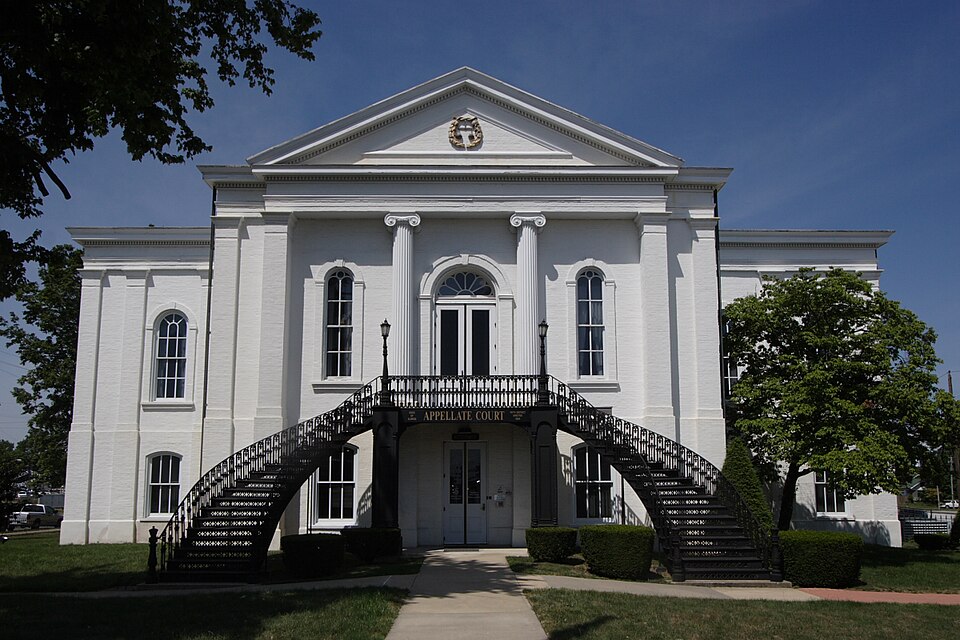
Photograph of 5th District Appellate Court
Photograph by Robert Lawton, CC BY 2.5. Via Wikimedia Commons.

Appellate Court, 5th District

Built in 1854 (Greek Revival architecture). Listed on the National Register of Historic Places in 1973.

From the record

“The 5th District Appellate Court is located in Mount Vernon, Illinois, an incorporated town in Jefferson County. The building was originally constructed for the southern division of the Illinois Supreme Court, which was created by the 1848 Illinois constitution.”

Wikipedia article 5th District Appellate Court, CC BY-SA 4.0.

One of 2 National Register listings published here for Jefferson County · listed in 1973 · category: Building · built in 1854, Greek Revival architecture.

Sources: the Wikipedia article · the case file at the National Archives · the National Register database, National Park Service

The listing

  • What is counted as historic. The nomination lists 1 building as contributing to the listing.
  • Address. 14th and Main Sts., Mount Vernon, 62864
  • When was it listed? July 1973
  • Category. building
  • Township. Mount Vernon township
  • When was it built? 1854
  • Architectural style. Greek Revival architecture
  • National Register reference number. 73000705 - the number the National Park Service assigned this property when it was listed, and the key its nomination file is catalogued under at the National Archives.

The ground it stands on

5,819 words

The chapter on Mount Vernon Township in Wall's History of Jefferson County, Illinois, published 1909 names Mount Vernon. This is what it says, exactly as the scans read.

Mount Vernon was chosen by the coirmiissioners as the name of the new county seat of justice, although Mount Pleasant was first proposed and favorably considered, but the name of Washington was greatly revered by the citizens, and Mount Vernon, his ancestral home, prevailed as the county seat of Jefferson county. Joel Pace was ordered by the court to contract with a surveyor to lay off the twenty acres, donated by William Casey, extending from Harrison street on the north to Jordon street, on the south, and from Casey street (now Eleventh street), on the west to Johnson street or alley, first street east of the public square. The lots numbered forty-eight, lying in eight squares, three squares each way, and one to the county, but nothing was said about blocks in the survey. The surveyor was William Hosick from - perhaps, Shawneetown. In September it was ordered that Joel Pace and William Casey be and are hereby employed to set Mulberry stakes around the public square, one at each corner, to drive all the stakes in the town and also to number the lots for which they are to be paid by the county.

Passage source: Wall's History of Jefferson County, Illinois, published 1909.

Lot No. I , was struck off to Bennett Maxey for forty-one dollars; No. 2 to Barton Atchison; Burchett Maxey bought No. 4, south of Herman's, where he built a log house; Lewis Watkins took the Joel Pace corner at one hundred sixty-two dollars and fifty cents; Nelson Ferguson took what is now the Ham's bank corner, one hundred and sixty-five dollars; Clark Casey, the Bond corner for one hundred and sixty dollars; Thomas Jordon, the lot where the Economy store now is; Doctor McLean, who afterwards located at McLeansboro, bought the Harvey Pace corner, where the third National Bank is, for one hundred and thirty-six dollars, with Isaac Casey as security. He failed to pay for it and Isaac passed it over to Burchett Maxey. J. E. Davis, the preacher who cried the sale of the lots, came in with a colony of Casey's and Maxey's in 1818. His wife was a sister to Burchett and Elihu Maxey's wives, and to James Bowman's and John Afflack's wives, all being daughters of John Taylor, of Wilson county, Tennessee. Of those who bought the original lots, Bennett Maxey was the son of William Maxey and brother to Joshua C. and J. P. Maxey, and was the father of William H. and James J., Charles C, Joshua C, Jr., and Thomas J.; also of Mrs. Emily Ray and Mrs. Eliza White; William and Edward were brothers from Virginia. William married Rhodam Allen's sister, Emily, and was the father of Henry B., Bennett Nelson, Elisha, Charles, Hardy, Joshua Cannon. William McKendrie, Adney and John, also of Mrs. Clarwall's history of JEFFERSON CO., ILL. 39 issa Johnson, Mrs. Harriet and Mrs. Vilinda Casey and Hostillina; Edward married Elizabeth Pitner, came to Kentucky and thence to IHinois, in 1819, was a Methodist and raised no children, but adopted Judge J. R. Satterfield. Barton Atchison was from Georgia, married a Hill, sister to Mrs. Wilkey and Mrs. Dempsey Hood, came to this county in 1816, and was much in public life. His sons were William, Ignitius, Samuel, George and the daughters, Winnie Myers, Martha Chaffin and one, the wife of Theophilus Cook, Jr., Nelson Ferguson, came and stayed one year and went back to Tennessee. His wife was a sister of Jordan Tyler. Clark Casey, John C, was a son of Abraham P., and son-in-law of Isaac Casey; came in 1818, and built a cabin on Mulberry Hill, southwest of town, lost his wife and married a Bingaman, went to Missouri, came back and died in 1862. Lewis Watkins was at the front some years, first in Moore's Prairie, then in Mount Vernon, finally returning to Tennessee, leaving his daughter, Mrs. Green P. Casey here. She was the mother of Lewis F. Casey. Henry Tyler was the son of John Tyler and John was a half-brother of James and Lewis Johnson. Henry married Isaac Casey's daughter, Catherine. He lived on the Centralia road for many years. John C. and Isaac Tyler were sons of Mrs. Ingram. Oliver Morris was son-in-law to Joseph Jordan. He built a brick house in Moore's Prairie as early as 1823. John Wilkerson married Dicy Keelin. in Virginia; she died and he married Mrs. Thomas, sister of Rhodam Allen and to William Maxey's wife. Mrs. Thomas by her first husband had five children; Mrs. Thad Moss's grandfather. Aunt Polly Parker and Edward Wilkinson's wife were three of them. This much for some of the very first settlers and builders of Mount Vernon.

Passage source: Wall's History of Jefferson County, Illinois, published 1909.

Machine-read from a century-old scan, so expect the errors a machine makes: misspelled names, dropped words, stray characters.

Read the whole chapter on Mount Vernon Township - 5,819 words on its settlement, mills, schools and churches.

Mines and quarries near this property

1 within 5 miles

Regional context, not property-specific evidence. The federal mineral resources record lists 1 working within 5 miles of Appellate Court, 5th District: 1 past producer. None of them still produces. What was taken out: Stone. Distance is straight-line from the map coordinates, so a quarry counted here may appear on a neighbouring settlement's page as well.

Where SiteCommodity StatusRecorded
Jefferson Cty Hwy Dept PitStonePast Producer

Every working recorded in Jefferson County

Storms near this property

2 since 1994

Regional context, not property-specific evidence. The National Weather Service names Mount Vernon, the town this property stands in, in 2 storm reports between 1994 and 1995: 1 thunderstorm wind, 1 hail. No death or injury is recorded in these reports. Each account below is quoted exactly as the forecast office filed it, from the NOAA Storm Events Database, and each date opens the federal record of that event.

WhenEvent Place namedHarm What the report says
April 1994Thunderstorm WindMount Vernon$5,000Large trees and power lines were blown down across various areas of the county. A school roof was damaged and windows blown out at Woodlawn.
May 1995HailMount Vernon-Reported by the Illinois State Police.

Every storm recorded in Jefferson County

Map coverage status

No historic map-sheet match is published for this property yet. That does not mean no map exists. This record needs a coordinate-quality review before it can be joined to a sheet boundary. Browse the county's mapped places while that work is pending.

Sources for this property

National Archives recordThe nomination case file for reference 73000705 in Record Group 79.
Wikipedia articleCommunity-written account of this property, licensed CC BY-SA.
Jefferson CountyAll 2 listed properties in this county.

Provenance

  • Listing record. National Park Service National Register of Historic Places, listed-properties dataset, current to 2026-05-22.
  • Map join. Address geocoded through the United States Census geocoder, then tested against the published boundary of every sheet in the USGS Historical Topographic Map Collection.
  • How this page is made. Listing fields come from federal records; map-sheet coverage is a labelled coordinate-to-boundary calculation, not a source-field claim.
  • Mines and quarries. USGS Mineral Resources Data System (MRDS) https://mrdata.usgs.gov/mrds/ A work of the United States government, no copyright under 17 U.S.C. 105.
  • Storms. NOAA National Centers for Environmental Information, Storm Events Database https://www.ncei.noaa.gov/stormevents/ A work of the United States government, no copyright under 17 U.S.C. 105. Narratives are quoted verbatim from the National Weather Service report and are not edited or summarised.