BlockBefore
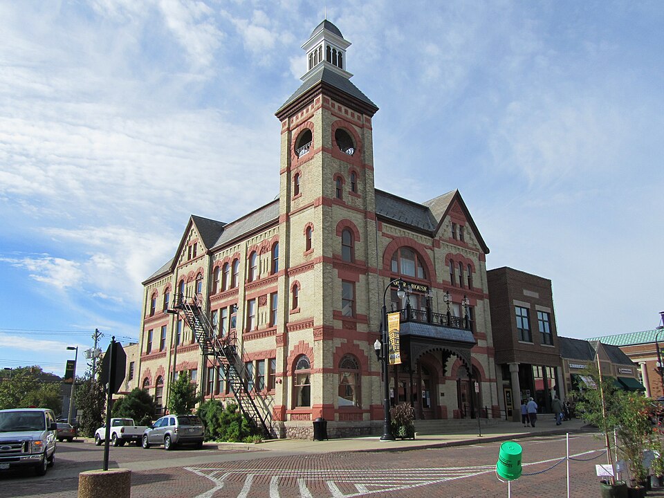
Photograph of Woodstock Opera House
Photograph by HrAtsuo, CC0 1.0. Via Wikimedia Commons.

Woodstock Opera House

Built in 1889. Listed on the National Register of Historic Places in 1974.

From the record

“The Woodstock Opera House is a historical venue for performing arts and receptions located in Woodstock, Illinois. It was built in 1889 and designed as a multi-use facility with space for city administration offices as well as police and fire departments.”

Wikipedia article Woodstock Opera House, CC BY-SA 4.0.

One of 13 National Register listings published here for McHenry County · listed in 1974 · category: Building · built in 1889.

Sources: the Wikipedia article · the case file at the National Archives · the National Register database, National Park Service

The listing

  • What is counted as historic. The nomination lists 1 building as contributing to the listing.
  • Address. 119 Van Buren St., Woodstock, 60098
  • When was it listed? July 1974
  • Category. building
  • Township. Greenwood township
  • When was it built? 1889
  • National Register reference number. 74002184 - the number the National Park Service assigned this property when it was listed, and the key its nomination file is catalogued under at the National Archives.

The ground it stands on

14,976 words

The chapter on Greenwood Township in History of McHenry County, Illinois : Together with Sketches of Its Cities, Villages and Towns : Educational, Religious, Civil, Military, and Political History : Portraits of Prominent Persons, and Biographies of Representative Citizens, Also a Condensed History of Illinois .., published 1885 names Woodstock. This is what it says, exactly as the scans read.

Mrs. S. T. Bryan is a native of Norway, born Sept. 5, 1820. She was married in Chicago, 111., to S. T. Bryan, being his third wife. They had no children. In 1843 Mr. Bryan came to Illinois and settled on the farm now occupied by his widow. He was one of the first Norwegian settlers of the county, and was one of its most respected citizens. He was influential in promoting many of the improvements of the township. The church opposite his farm was commenced and nearly finished by him. He was born Jan. 1, 1808, and died March 10, 1884, and was buried in the Scandinavian Cemetery. Mrs. Bryan's property is very valuable, being situated near Woodstock, and in the best farming portion of the county.

Passage source: History of McHenry County, Illinois : Together with Sketches of Its Cities, Villages and Towns : Educational, Religious, Civil, Military, and Political History : Portraits of Prominent Persons, and Biographies of Representative Citizens, Also a Condensed History of Illinois .., published 1885.

Henry Eckert. - Jacob Eckert and wife, whose maiden name was Margaret Smith, sailed from France in March, 1838, with one son, Henry, who at that time was but eleven years of age. In the fall of the same year he located in what is now called Greenwood Township, McHenry County, 111. His first purchase consisted of 160 acres of land which he at once set about to improve and resided there till his death in L872, at the age of eighty-six years and six months. His wife died in 1860. To them had been born three sons, two of whom came to America, Jacob and Henry, and one, Michael, died in France. Henry now owns and occupies the old Eckert homestead, half of the property coming by heirship, and the balance he purchased of his brother Jacob at $6 per acre, which at present is all under cultivation with line improvements comparing well with the best in Greenwood Township. Mr. Eckert has been constantly adding to the pioneer home until his possessions now number 466£ acres, comprising three separate farms, two of which are carried on by his sons William H. and Frank. The home place is conducted by George W . Our subject, until attaining his majority, was under the kind care and guidance of fond parents, which he in turn reciprocated when old age bade them retire from active life. Mr. Eckert was. married in 1847 to Miss Catharine Senger, daughter of Jacob and Magdaline (Neuhardt) Senger. To them were born seven children, four sons and three daughters - William H., George W., Frank, Charles F., Catharina (deceased), Catherine (deceased), and Linda, the wife of George Burger, of Hebron, who has two children, a son and daughter. George W. married Miss Bertha Sigwald and has two children, a son and daughter. Charles graduated from Northern Indiana Business Institute, Valparaiso, in 1884. Our subject is of pioneer stock and is one of the most prosperous and influential citizens of his town and county. Shortly after his marriage he was elected the second Tax Collector of his town, iu which capacity he acted two years. At the expiration of this service he was chosen by the people as Commissioner of Highways, which position (although not lucrative) he enjoyed for a period of fifteen years to the full satisfaction of all fair-minded citizens; was afterward elected Assessor, but declined to act, owing to the fact that he had previously decided to conduct the foundry and machine works in Woodstock, which he continued three years when he again returned to his farm, and the year following was elected as Supervisor of his town, thus bespeaking for him'the full confidence

Passage source: History of McHenry County, Illinois : Together with Sketches of Its Cities, Villages and Towns : Educational, Religious, Civil, Military, and Political History : Portraits of Prominent Persons, and Biographies of Representative Citizens, Also a Condensed History of Illinois .., published 1885.

Machine-read from a century-old scan, so expect the errors a machine makes: misspelled names, dropped words, stray characters.

Read the whole chapter on Greenwood Township - 14,976 words on its settlement, mills, schools and churches.

Fires near this property

1 since 2014

Regional context, not property-specific evidence. The federal wildfire occurrence database lists 1 fire within 5 miles of Woodstock Opera House in 2014, burning about 12 acres in total. None started naturally. None was recorded as arson. Distance is straight-line from the map coordinates, so a fire counted here may appear on a neighbouring settlement's page as well.

Reported cause Fires
Debris and open burning1

The most recent of them, most recent first, with the day each was reported and the service that recorded it.

DateCause SizeReported by Name on the report
26 April 2014Debris and open burning12 acresSavanna District, Upper Mississippi National Wildlife RefugeHACKMATACK PETERSON TRACT

Every fire recorded in McHenry County

Mines and quarries near this property

4 within 5 miles

Regional context, not property-specific evidence. The federal mineral resources record lists 4 workings within 5 miles of Woodstock Opera House: 2 past producers, 1 plant, 1 producer. 2 still produce. What was taken out: Sand and Gravel, Construction. Distance is straight-line from the map coordinates, so a quarry counted here may appear on a neighbouring settlement's page as well.

Where SiteCommodity StatusRecorded
Gavers Pit & MillSand and Gravel, ConstructionPlant
Reed PitSand and Gravel, ConstructionPast Producer
Rose Farm PitSand and Gravel, ConstructionProducer
Woodstock PitSand and Gravel, ConstructionPast Producer

Every working recorded in McHenry County

Storms near this property

60 of 69 shown

Regional context, not property-specific evidence. The National Weather Service names Woodstock, the town this property stands in, in 69 storm reports between 1996 and 2026: 38 thunderstorm wind, 20 hail, 5 lightning, 2 heavy rain. No death or injury is recorded in these reports. Each account below is quoted exactly as the forecast office filed it, from the NOAA Storm Events Database, and each date opens the federal record of that event.

WhenEvent Place namedHarm What the report says
August 2007Flash FloodWoodstock$500,000Intersection of Route 47 and 120 closed due to two feet of standing water. Willow and Clay Streets closed due to waist deep water. Police conducting rescues from stranded vehicles. Basement flooding was reported throughout Woodstock, and as many as 10 properties were flooded as a creek overflowed its banks in McHenry, IL.
August 1996LightningWoodstock$200,000no account filed
June 2009Tornado (EF1)Woodstock$75,000A tornado touched down near Highway 14 and Davis Road. At this location, several pine trees had large branches sheared and topped off with two of the trees partially uprooted. At this point the tornado was rated EF0 with winds estimated near 85 mph and a path width of 20 yards. The tornado continued northeast, crossing Highway 14, into a neighborhood where it increased in intensity and produced damage to structures and trees. Damage in the area was to a garage adjacent to a main house. This well built and fairly new garage was lifted and turned off of its foundation, which was securely bolted to a concrete finish. Damage at this location was rated EF1 with winds estimated near 100 mph and a path width of 75 yards. The tornado proceeded to move northeast through the neighborhood where it uprooted four old but healthy soft and hard wood trees. Just to the northeast of this neighborhood is a commercial district where the tornado produced damage to two buildings. Damage occurred to the roof of one building with the other building sustaining damage to one of its exterior walls. The wall was partially collasped but it was an older structure. EF1 damage was produced at this point with winds estimated near 100 mph and a path width of 30 yards. The tornado weakened as it moved northeast, producing damage to trees near and along Lake Road. The tornado appeared to have lifted with no other damage evident beyond this point.
August 2007Thunderstorm WindWoodstock$30,000A 90 foot tall, 45 inch diameter tree was blown onto a house, causing significant damage to the roof, attic, a bathroom and a bedroom.
July 2011LightningWoodstock$10,000Lightning knocked ornamental stonework from the bell tower of the Woodstock Opera House.
March 2012LightningWoodstock$5,000Lightning struck a satellite dish on the roof of a building of condos, which started a fire in the attic. Only minor damage was reported and the condo remained habitable.
July 2012Thunderstorm WindWoodstock$2,000Utility poles were snapped at Kimball Avenue and Bunker Street.
June 2017Thunderstorm WindWoodstock$1,000Trees and power lines were blown down.
June 2009Thunderstorm WindWoodstock$1,000A large tree was uprooted and blown over along Judd Street. The root ball damaged part of a driveway and sidewalk.
June 2009Thunderstorm WindWoodstock$1,000Tree limbs and power lines were blown down.
May 2006LightningWoodstock$1,000Lightning strike at IL 47 and Donovan Road brought down power lines.
May 2001LightningWoodstock$1,000Lightning ignited the wooden roof of an historic old home causing one thousand dollars damge. The house was built in 1852.
April 2026Thunderstorm WindWoodstock-Broadcast media reported a tree down on a house on the 600 block of S Jefferson St in Woodstock.
March 2025Thunderstorm WindWoodstock-Multiple reports were received of tree and fence damage in Woodstock.
June 2025Thunderstorm WindWoodstock-A 6 to 8 inch diameter tree branch was downed onto power lines near the intersection of Jackson and Douglas streets in Woodstock.
August 2025Thunderstorm WindWoodstock-A tree had fallen onto a house along Clay St in Woodstock.
August 2025Thunderstorm WindWoodstock-Woodstock PD reported multiple power lines downed around Woodstock.
June 2024HailWoodstock-One inch hail was reported on the 300 block of N Rose Farm Rd in Woodstock.
June 2024HailWoodstock-One inch hail was reported on the 400 block of Shannon Dr in Woodstock.
June 2024Heavy RainWoodstock-Storm total rainfall of 4.68 was recorded in Woodstock.
June 2024Heavy RainWoodstock-Mesonet station DW7142 recorded 3.8 of rain.
July 2024Thunderstorm WindWoodstock-Several trees and power lines were blown down near Washington Street and Lamb Road, blocking roadways.
August 2024HailWoodstock-A trained spotter reported 1.75 hail near US Rt. 14 and Dean St.
August 2024Thunderstorm WindWoodstock-Several trees were reported down in and around Woodstock.
April 2023Thunderstorm WindWoodstock-A wind gust to 58 mph was measured near Woodstock.
March 2023Thunderstorm WindWoodstock-Strong winds had blown down a tree west of Woodstock. Wind magnitude and time were estimated based on radar.
July 2023Thunderstorm WindWoodstock-Part of a tree was reported uprooted near Flagg Lane and Hickman Lane in Woodstock.
July 2022Thunderstorm WindWoodstock-A photo showed tree damage at Emricson Park near South Street.
July 2021Thunderstorm WindWoodstock-A photo shared on social media showed a large tree snapped at its base in Emricson Park.
August 2021Thunderstorm WindWoodstock-A large tree was snapped halfway up.
August 2020Thunderstorm WindWoodstock-A couple of large trees were blown down between Woodstock and Bull Valley.
September 2018FloodWoodstock-Water from retention ponds overflowed onto some streets with about 3 inches of standing flood waters.
June 2017Thunderstorm WindWoodstock-Multiple trees were blown down between Woodstock and Wonder Lake. A tree was blocking the road at Banford and Queen Anne and another tree was blocking Thompson north of Route 120.
April 2014HailWoodstock-Dime to quarter size hail covered the ground near Queen Anne Street and Todd Avenue.
July 2012Thunderstorm WindWoodstock-Wind gusts were estimated to 65 mph.
May 2011HailWoodstock-Dime to nickel size hail was reported at the intersection of Route 14 and Route 47.
June 2009Thunderstorm WindWoodstock-A large tree was blown over onto train tracks and a passenger car near a train station.
June 2009Thunderstorm WindWoodstock-A large tree was blown down blocking South Street.
July 2007Thunderstorm WindWoodstock-A tree was blown down.
July 2007Thunderstorm WindWoodstock-A gust to 67 mph was measured.
July 2007Thunderstorm WindWoodstock-A gust to 60 mph was measured near Route 47 and Lucus.
December 2007Thunderstorm WindWoodstock-A tree was blown down blocking Mcconnell Road at Lily Pond.
August 2007Thunderstorm WindWoodstock-Measured wind gust to 62 mph.
August 2007Thunderstorm WindWoodstock-A spotter measured a wind gust to 63 mph.
May 2006Thunderstorm WindWoodstock-A six inch tree limb was blown down near Country Club Road and a tree was blown down on Dean Street.
July 2006Thunderstorm WindWoodstock-Trees were blown down in Bull Valley.
February 1999Thunderstorm WindWoodstock-Shingles were blown off a house and tree limbs were blown down in Woodstock and Lake in the Hills.
May 1998Thunderstorm WindWoodstock-Strong thunderstorm winds gusted to 68mph in McHenry and 70mph in Richmond.
July 1998Thunderstorm WindWoodstock-Trees were blown down in Woodstock. Trees were uprooted and limbs blown down in Mc Henry. One tree fell through the roof of a house. A metal shed was blown 150 yards.
August 2025HailWoodstock-no account filed
August 2024HailWoodstock-no account filed
September 2021HailWoodstock-no account filed
April 2020HailWoodstock-no account filed
April 2015HailWoodstock-no account filed
March 2012HailWoodstock-no account filed
July 2009Funnel CloudWoodstock-no account filed
April 2006HailWoodstock-no account filed
May 2006HailWoodstock-no account filed

Every storm recorded in McHenry County

Map coverage status

No historic map-sheet match is published for this property yet. That does not mean no map exists. This record needs a coordinate-quality review before it can be joined to a sheet boundary. Browse the county's mapped places while that work is pending.

Listed places nearby

4 within 8 miles

Other National Register properties close enough to walk or drive between, ordered by distance from this one. Both positions come from the same geocoding pass that matched these properties to their map sheets.

Photograph PropertyDistance Listed
Woodstock Square Historic District1.1 miles1982
Old McHenry County Courthouse1.1 miles1974
Terwilliger House5.1 miles1979
George Stickney House5.3 miles1979

Sources for this property

National Archives recordThe nomination case file for reference 74002184 in Record Group 79.
Wikipedia articleCommunity-written account of this property, licensed CC BY-SA.
McHenry CountyAll 13 listed properties in this county.

Provenance

  • Listing record. National Park Service National Register of Historic Places, listed-properties dataset, current to 2026-05-22.
  • Map join. Address geocoded through the United States Census geocoder, then tested against the published boundary of every sheet in the USGS Historical Topographic Map Collection.
  • How this page is made. Listing fields come from federal records; map-sheet coverage is a labelled coordinate-to-boundary calculation, not a source-field claim.
  • Wildfire. Short, Karen C. 2022. Spatial wildfire occurrence data for the United States, 1992-2020 [FPA_FOD_20221014]. 6th Edition. Fort Collins, CO: Forest Service Research Data Archive. https://doi.org/10.2737/RDS-2013-0009.6 Collected with United States Government funding and usable without additional permissions or fees.
  • Mines and quarries. USGS Mineral Resources Data System (MRDS) https://mrdata.usgs.gov/mrds/ A work of the United States government, no copyright under 17 U.S.C. 105.
  • Storms. NOAA National Centers for Environmental Information, Storm Events Database https://www.ncei.noaa.gov/stormevents/ A work of the United States government, no copyright under 17 U.S.C. 105. Narratives are quoted verbatim from the National Weather Service report and are not edited or summarised.