BlockBefore
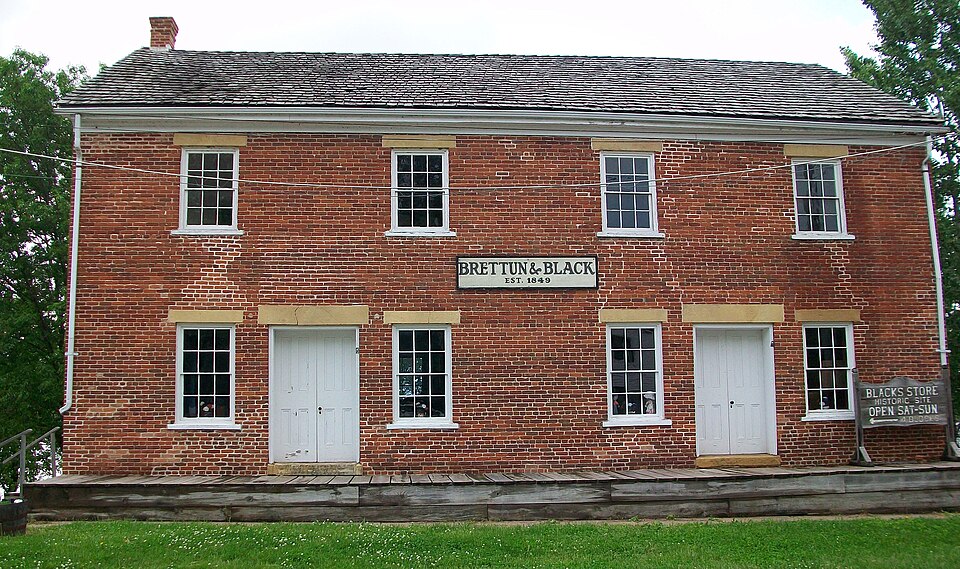
Photograph of Black's Store
Photograph by Ctjf83, CC BY-SA 3.0. Via Wikimedia Commons.

Black's Store

Listed on the National Register of Historic Places in 1976.

From the record

“Black's Store, also known as the Brettun & Black Museum, is an historic building located in Hampton, Illinois, United States. The mercantile store was built in 1849 and was the largest store in Northwest Illinois when it opened.”

Wikipedia article Black's Store, CC BY-SA 4.0.

One of 29 National Register listings published here for Rock Island County · listed in 1976 · category: Building.

Sources: the Wikipedia article · the case file at the National Archives · the National Register database, National Park Service · the Wikipedia article


The listing

  • What is counted as historic. The nomination lists 1 building as contributing to the listing.
  • Address. 1st Ave., Hampton, 61256
  • When was it listed? May 1976
  • Category. building
  • Township. Hampton township
  • National Register reference number. 76000727 - the number the National Park Service assigned this property when it was listed, and the key its nomination file is catalogued under at the National Archives.

The ground it stands on

807 words

The chapter on Hampton Township in Historic Rock Island County; History of the Settlement of Rock Island County from the Earliest Known Period to the Present Time ... Embracing References of Importance, and Including a Biography of Rock Island County's Well-known Citizens, published 1908 names Hampton. This is what it says, exactly as the scans read.

The Village of Hampton, in Hampton Township, was surveyed and platted soon after the organization of Rock Island County. Among the earliest business men were Joel Thompson, Alonzo P. Clapp, Dower and Hammond, Samuel and David Lambert, M. W. Wright and Francis Black, followed by L. F. Baker, H. F. Thomas, H. O. Norton, Dr. George Vincent, S. L. Brettun, and Wm. B. Webster. The first postoffice was established in the winter of 1837, Joel Thompson being commissioned postmaster, followed by Francis Black, Samuel Heagy and L. F Baker. From the earliest settlement Hampton was one of the principal points for supplies for the farmers in the upper end of the county, and even considerable territory in Henry County. Here they brought their grain and sold their pork, which was packed by M. W. Wright and Francis Black, and shipped down the river by the steamboats. In after years the coal interests were the principal business reliance; Heagy and Stoddard and Taylor Williams being extensive operators. In 1884 Heagy and Stoddard were succeeded by the Northern Mining & Railway Company, who ceased operations about fifteen

Passage source: Historic Rock Island County; History of the Settlement of Rock Island County from the Earliest Known Period to the Present Time ... Embracing References of Importance, and Including a Biography of Rock Island County's Well-known Citizens, published 1908.

The assessors' plats show there exists in the Village of Hampton, an old village called Milan, which was platted in 1837. The plat showing about thirty blocks. In this district at the present time are only four or five houses. In that year the postoffice department at Washington, D. C, was petitioned for a postoffice at this place to be called Milan. There being a postoffice of that name already in the state, the department established the postoffice under the name of Hampton, from which name the township and village derive their names.

Passage source: Historic Rock Island County; History of the Settlement of Rock Island County from the Earliest Known Period to the Present Time ... Embracing References of Importance, and Including a Biography of Rock Island County's Well-known Citizens, published 1908.

Machine-read from a century-old scan, so expect the errors a machine makes: misspelled names, dropped words, stray characters.

Read the whole chapter on Hampton Township - 807 words on its settlement, mills, schools and churches.

Fires near this property

4 since 2008

Regional context, not property-specific evidence. The federal wildfire occurrence database lists 4 fires within 5 miles of Black's Store between 2008 and 2017, burning about 12 acres in total. None started naturally. None was recorded as arson. Distance is straight-line from the map coordinates, so a fire counted here may appear on a neighbouring settlement's page as well.

Reported cause Fires
Debris and open burning3
Missing data/not specified/undetermined1

The most recent of them, most recent first, with the day each was reported and the service that recorded it.

DateCause SizeReported by Name on the report
4 July 2008Debris and open burningunder an acreIllinois Division of Forestry ResourcesTREE
3 July 2017Debris and open burning1.0 acresIllinois Division of Forestry Resources17-111
3 April 2011Missing data/not specified/undetermined10 acresIowa Department of Natural ResourcesH AVE AND E 49, IA
16 December 2017Debris and open burningunder an acreIllinois Division of Forestry Resources17-200

Every fire recorded in Rock Island County

Mines and quarries near this property

3 within 5 miles

Regional context, not property-specific evidence. The federal mineral resources record lists 3 workings within 5 miles of Black's Store: 2 past producers, 1 producer. 1 still produces. What was taken out: Stone, Crushed/Broken. Distance is straight-line from the map coordinates, so a quarry counted here may appear on a neighbouring settlement's page as well.

Where SiteCommodity StatusRecorded
Bettendorf Stone Co. QuarryStone, Crushed/BrokenPast Producer
Le Claire QuarryStone, Crushed/BrokenProducer
UnknownStone, Crushed/BrokenPast Producer

Every working recorded in Rock Island County

Storms near this property

3 since 2010

Regional context, not property-specific evidence. The National Weather Service names Hampton, the town this property stands in, in 3 storm reports between 2010 and 2023: 1 thunderstorm wind, 1 lightning, 1 hail. No death or injury is recorded in these reports. Each account below is quoted exactly as the forecast office filed it, from the NOAA Storm Events Database, and each date opens the federal record of that event.

WhenEvent Place namedHarm What the report says
June 2010LightningHampton$2,000Lightning struck a house, setting fire to the attic. Time is estimated.
September 2010Thunderstorm WindHampton-Wind gusts estimated to be 60 mph blew down a 3 inch diameter tree branch across a road in Hampton, IL around 335 pm CDT September 21.
March 2023HailHampton-no account filed

Every storm recorded in Rock Island County

Map coverage status

No historic map-sheet match is published for this property yet. That does not mean no map exists. This record needs a coordinate-quality review before it can be joined to a sheet boundary. Browse the county's mapped places while that work is pending.

Listed places nearby

6 within 8 miles

Other National Register properties close enough to walk or drive between, ordered by distance from this one. Both positions come from the same geocoding pass that matched these properties to their map sheets.

Photograph PropertyDistance Listed
LeClaire Hotel6.0 miles1994
Moline Downtown Commercial Historic District6.3 miles2007
Rock Island National Cemetery6.4 miles1997
John Deere House6.7 miles2003
Skelly Service Station6.8 miles2024
Garfield Elementary School7.1 miles2017

Sources for this property

National Archives recordThe nomination case file for reference 76000727 in Record Group 79.
Wikipedia articleCommunity-written account of this property, licensed CC BY-SA.
Rock Island CountyAll 29 listed properties in this county.

Provenance

  • Listing record. National Park Service National Register of Historic Places, listed-properties dataset, current to 2026-05-22.
  • Map join. Address geocoded through the United States Census geocoder, then tested against the published boundary of every sheet in the USGS Historical Topographic Map Collection.
  • How this page is made. Listing fields come from federal records; map-sheet coverage is a labelled coordinate-to-boundary calculation, not a source-field claim.
  • Wildfire. Short, Karen C. 2022. Spatial wildfire occurrence data for the United States, 1992-2020 [FPA_FOD_20221014]. 6th Edition. Fort Collins, CO: Forest Service Research Data Archive. https://doi.org/10.2737/RDS-2013-0009.6 Collected with United States Government funding and usable without additional permissions or fees.
  • Mines and quarries. USGS Mineral Resources Data System (MRDS) https://mrdata.usgs.gov/mrds/ A work of the United States government, no copyright under 17 U.S.C. 105.
  • Storms. NOAA National Centers for Environmental Information, Storm Events Database https://www.ncei.noaa.gov/stormevents/ A work of the United States government, no copyright under 17 U.S.C. 105. Narratives are quoted verbatim from the National Weather Service report and are not edited or summarised.