
BlockBefore
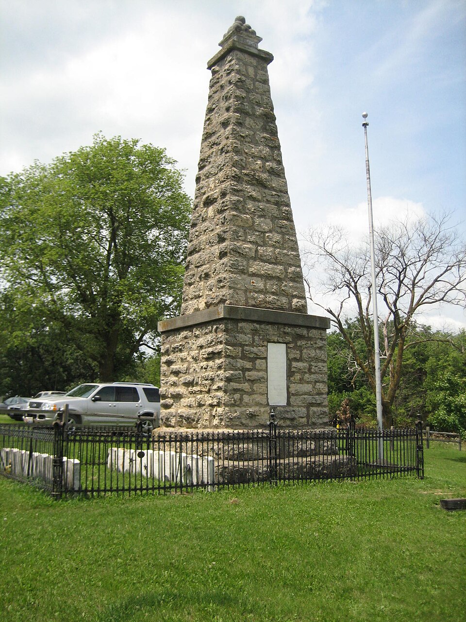
Photograph of Kellogg's Grove
Photograph by IvoShandor, CC BY 2.5. Via Wikimedia Commons.

Kellogg's Grove

Listed on the National Register of Historic Places in 1978.

From the record

“Kellogg's Grove is an area in western Stephenson County, Illinois, United States near the present-day unincorporated town of Kent. The grove is considered historically significant because it was the site of two minor skirmishes during the Black Hawk War in 1832.”

Wikipedia article Kellogg's Grove, CC BY-SA 4.0.

One of 16 National Register listings published here for Stephenson County · listed in 1978 · category: Site.

Sources: the Wikipedia article · the case file at the National Archives · the National Register database, National Park Service · the Wikipedia article
The listing

  • Address. SE of Kent, Kent, 61062
  • When was it listed? June 1978
  • Category. site
  • Township. Kent township
  • National Register reference number. 78001191 - the number the National Park Service assigned this property when it was listed, and the key its nomination file is catalogued under at the National Archives.

The ground it stands on

4,342 words

The chapter on Kent Township in The History of Stephenson County, Illinois : Containing ... Biographical Sketches ... War Record ... Statistics ... Portraits of Early Settlers ... History of the Northwest, History of Illinois, &c. .., published 1880 names Kent. This is what it says, exactly as the scans read.

Previous to this last date, a mill had been erected on Yellow Creek by John and Frederick Reber, and, as it was near the center of the township, it was liberally patronized. Before its completion, the settlers had been obliged to procure the grinding of their cereals at Craig's mill, on Apple River, at Buffalo Creek in Ogle County, and elsewhere. The inhabitants obtained their supplies of bacon from Galena or Dixon, and when short of " hog-meat," indulged an appetite for game, which was to be found in abundance in the winter, on barrens and prairie. In 1837, a school was opened by William Ensign in the house of James Timras, where he taught the young idea, acknowledged by the Timms, Maginnis, Giddings and Willet families, the rudiments of reading, writing and arithmetic. By these and kindred means did the early pioneers of Kent Township not only dissipate dull care, but contributed in providing substantial means for future wealth and civilization.

Passage source: The History of Stephenson County, Illinois : Containing ... Biographical Sketches ... War Record ... Statistics ... Portraits of Early Settlers ... History of the Northwest, History of Illinois, &c. .., published 1880.

Among others who settled up the township was Thomas Carter, Isaac Rand, etc. ; Samuel Bailey settled across Yellow Creek ; Jacob Gable came in and purchased the Maginnis place ; L. L. L. Pitcher, who is still living near the old Timms place ; a man named Lathrop, with some few others, were among the number who became identified with the cultivation and development of the county in that portion subsequently allotted to Kent.

Passage source: The History of Stephenson County, Illinois : Containing ... Biographical Sketches ... War Record ... Statistics ... Portraits of Early Settlers ... History of the Northwest, History of Illinois, &c. .., published 1880.

Machine-read from a century-old scan, so expect the errors a machine makes: misspelled names, dropped words, stray characters.

Read the whole chapter on Kent Township - 4,342 words on its settlement, mills, schools and churches.

Fires near this property

2 since 2004

Regional context, not property-specific evidence. The federal wildfire occurrence database lists 2 fires within 5 miles of Kellogg's Grove in 2004, burning about 22 acres in total. None started naturally. None was recorded as arson. Distance is straight-line from the map coordinates, so a fire counted here may appear on a neighbouring settlement's page as well.

Reported cause Fires
Recreation and ceremony2

The most recent of them, most recent first, with the day each was reported and the service that recorded it.

DateCause SizeReported by Name on the report
7 April 2004Recreation and ceremony20 acresIllinois State Fire Marshal's Officenot named
17 April 2004Recreation and ceremony2.0 acresIllinois State Fire Marshal's Officenot named

Every fire recorded in Stephenson County

Mines and quarries near this property

10 within 5 miles

Regional context, not property-specific evidence. The federal mineral resources record lists 10 workings within 5 miles of Kellogg's Grove: 8 past producers, 2 producers. 2 still produce. What was taken out: Stone, Crushed/Broken, Sand and Gravel, Construction, Limestone, General. Distance is straight-line from the map coordinates, so a quarry counted here may appear on a neighbouring settlement's page as well.

Where SiteCommodity StatusRecorded
Hallelman QuarryLimestone, GeneralPast Producer
A & K Thompson PitSand and Gravel, ConstructionPast Producer
Kent Gravel PitSand and Gravel, ConstructionProducer
Caudle Qy Formerly Msha #1100089Stone, Crushed/BrokenPast Producer
Lena PitStone, Crushed/BrokenProducer
Unnamed Limestone QuarryStone, Crushed/BrokenPast Producer

Every working recorded in Stephenson County

Storms near this property

9 since 2003

Regional context, not property-specific evidence. The National Weather Service names Kent, the town this property stands in, in 9 storm reports between 2003 and 2021: 6 hail, 3 thunderstorm wind. No death or injury is recorded in these reports. Each account below is quoted exactly as the forecast office filed it, from the NOAA Storm Events Database, and each date opens the federal record of that event.

WhenEvent Place namedHarm What the report says
July 2009HailKent$50,000Hail estimated to be 2 inches in diameter fell about 1.5 miles north northeast of Kent, IL around 615 pm July 24. The hail caused widespread crop damage as well as damage to some residences and vehicles in the area.
August 2003HailKent$20,000no account filed
August 2003HailKent$10,000no account filed
July 2021Thunderstorm WindKent-Trees blown down.
June 2010Thunderstorm WindKent-Wind gusts measured to be 60 mph were observed near Kent, IL at 210 pm June 18.
July 2009HailKent-Hail 2 inches in diameter fell about 5 miles west southwest of Lena, IL around 602 pm July 24.
July 2008HailKent-Dime-sized hail fell near Kent, IL at 12:35 pm July 31.
July 2008Thunderstorm WindKent-Wind gusts measured to be 70 mph were observed near Kent, IL at 12:29 pm July 31.

Every storm recorded in Stephenson County

Map coverage status

No historic map-sheet match is published for this property yet. That does not mean no map exists. This record needs a coordinate-quality review before it can be joined to a sheet boundary. Browse the county's mapped places while that work is pending.

Listed places nearby

2 within 8 miles

Other National Register properties close enough to walk or drive between, ordered by distance from this one. Both positions come from the same geocoding pass that matched these properties to their map sheets.

Photograph PropertyDistance Listed
Lena Water Tower6.6 miles1997
Chris Jensen Round Barn7.2 miles1984

Sources for this property

National Archives recordThe nomination case file for reference 78001191 in Record Group 79.
Wikipedia articleCommunity-written account of this property, licensed CC BY-SA.
Stephenson CountyAll 16 listed properties in this county.

Provenance

  • Listing record. National Park Service National Register of Historic Places, listed-properties dataset, current to 2026-05-22.
  • Map join. Address geocoded through the United States Census geocoder, then tested against the published boundary of every sheet in the USGS Historical Topographic Map Collection.
  • How this page is made. Listing fields come from federal records; map-sheet coverage is a labelled coordinate-to-boundary calculation, not a source-field claim.
  • Wildfire. Short, Karen C. 2022. Spatial wildfire occurrence data for the United States, 1992-2020 [FPA_FOD_20221014]. 6th Edition. Fort Collins, CO: Forest Service Research Data Archive. https://doi.org/10.2737/RDS-2013-0009.6 Collected with United States Government funding and usable without additional permissions or fees.
  • Mines and quarries. USGS Mineral Resources Data System (MRDS) https://mrdata.usgs.gov/mrds/ A work of the United States government, no copyright under 17 U.S.C. 105.
  • Storms. NOAA National Centers for Environmental Information, Storm Events Database https://www.ncei.noaa.gov/stormevents/ A work of the United States government, no copyright under 17 U.S.C. 105. Narratives are quoted verbatim from the National Weather Service report and are not edited or summarised.