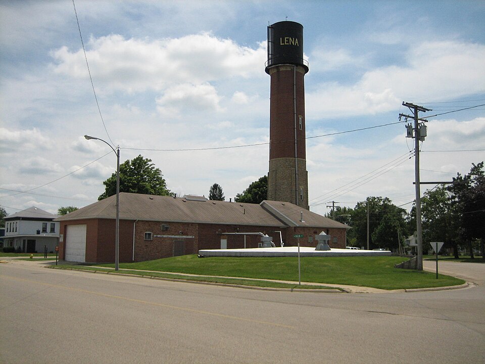
Listed on the National Register of Historic Places in 1997.
From the record
“The Lena Water Tower is a water tower located in the village of Lena, Illinois, United States. It was built in 1896 following two decades of problems with structure fires in the village.”
Wikipedia article Lena Water Tower, CC BY-SA 4.0.
One of 16 National Register listings published here for Stephenson County · listed in 1997 · category: Structure.
National Register reference number.97000034- the number the National Park Service assigned this property when it was listed, and the key its nomination file is catalogued under at the National Archives.
JACOB ACKER, farmer; P.O. Lena; born Sept. 28, 1814, in Mifflin Co., Penn.; he learned the carpenter trade in Union Co., Penn., following the business until 1843, when he came to Stephenson Co. ; he has followed farming and the carpenter's trade since coming to this county ; he now owns 65 acres ; part of this land is inside the corporation, and he owns other town property ; he has been Justice of the Peace and County Superintendent ; he was Postmaster in Lowell, Jefferson Township ; he also was School Treasurer and Director. Married Amelia Himes in 1839 ; she was born in Union Co., Penn., in 1818; they had nine children, six living - George H., Mary E., Kate, Margaret A., Jane and Viola F. ; George H. enlisted in 1861, in the 92d T. V. I.; served about one year, and was discharged on account of sickness.
H. W. ALLEN, nursery and farmer, Sec. 32 ; P. 0. Lena ; born Aug. 4, 1842, in Galena, 111.; when about three years of age, he came with his parents to his present locality ; his father formerly owned about 400 acres of land ; part of this land is now occupied by the lumber yard, depot, etc.; they own now 80 acres, and he is largely engaged in the nursery business, consisting of fruit and ornamental trees, it is equal to any nursery in the county. Married Miss Cordelia Aurand, in 1865 ; she was born in Carlisle, Penn.; they have six children, three sons and three daughters. He enlisted in 1864, in Co. A, 14:2d I. V. I., as Sergeant, and served about six months. His father died in November, 1864, aged 50 years.
Regional context, not property-specific
evidence. The
federal wildfire occurrence database
lists 6 fires within 5 miles of Lena Water Tower
between 2004 and 2008, burning about 99 acres in total. None started naturally. 1 was recorded as arson.
Distance is straight-line from the map coordinates, so a fire counted
here may appear on a neighbouring settlement's page as well.
Reported cause
Fires
Recreation and ceremony
4
Debris and open burning
1
Arson/incendiarism
1
The most recent of
them, most recent first, with the day each was reported and the service
that recorded it.
Regional context, not property-specific
evidence. The federal mineral resources record lists
15 workings within 5 miles of Lena Water Tower: 10 past producers, 3 producers, 1 occurrence, 1 prospect.
3 still produce. What was taken out: Stone, Crushed/Broken, Sand and Gravel, Construction, Copper. Distance is straight-line from the
map coordinates, so a quarry counted here may appear on a neighbouring
settlement's page as well.
Regional context, not property-specific
evidence. The National Weather Service names
Lena, the town this property stands in, in 43 storm reports between 1997 and 2026: 19 thunderstorm wind, 7 heavy rain, 7 hail, 6 flash flood.
No death or injury is recorded in these reports. Each account below is quoted exactly as the forecast office
filed it, from the NOAA Storm Events Database, and each date
opens the federal record of that event.
Wind gusts estimated to be 65 mph blew down four utility poles near the intersection of N 5 Corners Rd and Highway 20 about 2 miles south southwest of Lena, IL around 9:30 pm July 7. A power outage was observed in several surrounding communities. This report was relayed by the Freeport Journal Standard newspaper.
Heavy rains of 3 to 7 inches fell across Stephenson County during the early morning hours of August 7th resulting in flash flooding. Two feet of water was coving parts of Highway 20 east of Highway 73. Some motorists were stranded in high water in Freeport, IL. Several gravel roads east of the Highway 20 and Highway 73 intersection were washed out. The US Bank and Health Department buildings in Freeport had flooded basements.
Downburst leveled several trees 2.5 to 3 feet in diameter along with power lines. The trees were solid but had been weakened by severe storms back in August.
A high-end EF2, possible multi-vortex, tornado with estimated peak winds around 130 mph started along Highway 20, southwest of Lena IL, and tracked through Lena before lifting just southwest of Orangeville. The tornado caused significant damage to trees along its path, including uprooting and snapping trees. When the tornado begun it immediately caused EF1 damage to trees, gaining strength to an EF2 tornado snapping many power poles southwest of Lena. The tornado turned to the right, into town causing a lot of roof damage and tree damage. A lot of houses had shingle and siding damage. The most significant damage occurred on Grove Street, where three houses lost their entire roof structure. Two of the homes experienced partial exterior wall collapses. Damage in this area is consistent with 130 MPH winds. In Lena, the damage footprint in Lena is approximately 1250 yards wide. As the tornado moved to the northeast, damage to farm structures was noted. Even towards the end of the path, the tornado was causing EF1 damage to trees.
A trained spotter reported widespread flooding. A road was underwater for at least the length of a football field in a location does not normally flood.
Local law enforcement reported 4 road closures in Stephenson County due to flash flooding. Highway 20 west was closed at Damier Road. Highway 20 was closed at Kiever Road. Highway 20 was closed west of Galena Road to the county line. Highway 73 was closed west of Louisa Road.
No historic map-sheet match is published
for this property yet. That does not mean no map exists. This record needs
a coordinate-quality review before it can be joined to a sheet boundary.
Browse the county's mapped places while that work is
pending.
Listed places nearby
4 within 8 miles
Other National Register properties close
enough to walk or drive between, ordered by distance from this one. Both
positions come from the same geocoding pass that matched these properties
to their map sheets.
Listing record. National Park Service National Register of Historic Places, listed-properties dataset, current to 2026-05-22.
Map join. Address geocoded through the United States Census geocoder, then tested against the published boundary of every sheet in the USGS Historical Topographic Map Collection.
How this page is made. Listing fields come from federal records; map-sheet coverage is a labelled coordinate-to-boundary calculation, not a source-field claim.
Wildfire. Short, Karen C. 2022. Spatial wildfire occurrence data for the United States, 1992-2020 [FPA_FOD_20221014]. 6th Edition. Fort Collins, CO: Forest Service Research Data Archive. https://doi.org/10.2737/RDS-2013-0009.6 Collected with United States Government funding and usable without additional permissions or fees.
Mines and quarries. USGS Mineral Resources Data System (MRDS) https://mrdata.usgs.gov/mrds/ A work of the United States government, no copyright under 17 U.S.C. 105.
Storms. NOAA National Centers for Environmental Information, Storm Events Database https://www.ncei.noaa.gov/stormevents/ A work of the United States government, no copyright under 17 U.S.C. 105. Narratives are quoted verbatim from the National Weather Service report and are not edited or summarised.
 Block