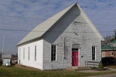
Listed on the National Register of Historic Places in 1978.
From the record
“The Illinois Traction System Mackinaw Depot is a former in use 1909 to 1953 Illinois Terminal Railroad interurban passenger depot in Mackinaw, Illinois that still stands. The Illinois Terminal Railroad ran an over head trolley wire powered railroad from Peoria on the north to St.”
Wikipedia article Mackinaw station, CC BY-SA 4.0.
One of 16 National Register listings published here for Tazewell County · listed in 1978 · category: Building.
National Register reference number.78001192- the number the National Park Service assigned this property when it was listed, and the key its nomination file is catalogued under at the National Archives.
The early history of the villags of Mackinaw is very fully detailed in the second chapter of this History, we therefore deem it unnecessary to record it here. The present population of the town is about 800. It is on the line of the I., B. & W., and I. M. Railroads. The first post-office was established in 1827. Mordecai Mobley was the first postmaster ; the present postmaster is James E. Hill. There is one drug store, three grocery stores, one furniture store, one hardAvare store, and two of general merchandise, one hotel, one large agricultural implement house, three wagon shops, and a grist-mill. There is a Masonic lodge, which was organized over a half century ago, and is now in a flourishing condition. The Trustees of the town are as follows : Daniel Beckly, James H. Porter, J. L. Davis, Thomas Higgins, and J. H. Wilson.
Christian Church. - From the earliest settlement of Mackinaw township, dating as for back as 1826, there were occasional religious meetings held at private houses and subsequently school-houses. Methodist, Cumberland Presbyterian, United Brethren, occasionally a Baptist, a New Light, or Old Christian preacher, living in other settlements, or traveling through, would stop with the friendly pioneers and preach to those who would gather in. These meetings were not without some good effect. In 183-t, Elder James A. Lindsey came from Kentucky and settled in the east part of the township. He was a minister of the Disciples or Christian Church, and was, perhaps, the first resident preacher of the township ; was a man of sterling worth and integrity, kind and genial in disposition, and ardently devotional. He began at once the proclamation of the Gospel as taught by this people. Having a large family, and realizing the importance of regular church influence, he soon made it a special feature of his work to establish the cause in his own neighborhood. He was successful in harmonizing some of other religious views, and baptizing others who had made no profession. These efforts resulted in a meeting for consolidation, which was held at his house in Sept., 1837, and on the 5th day of October, at what was known as Mt. Pleasant school-house, the first Christian Church of the township, and perhaps the first, that was strictly on that basis, in the county. The Methodist Conference had established a station at
Regional context, not property-specific
evidence. The
federal wildfire occurrence database
lists 5 fires within 5 miles of Illinois Traction System Mackinaw Depot
between 2011 and 2012, burning about 17 acres in total. None started naturally. None was recorded as arson.
Distance is straight-line from the map coordinates, so a fire counted
here may appear on a neighbouring settlement's page as well.
Reported cause
Fires
Debris and open burning
2
Missing data/not specified/undetermined
2
Equipment and vehicle use
1
The most recent of
them, most recent first, with the day each was reported and the service
that recorded it.
Regional context, not property-specific
evidence. The federal mineral resources record lists
5 workings within 5 miles of Illinois Traction System Mackinaw Depot: 3 past producers, 2 producers.
2 still produce. What was taken out: Sand and Gravel, Construction. Distance is straight-line from the
map coordinates, so a quarry counted here may appear on a neighbouring
settlement's page as well.
Regional context, not property-specific
evidence. The National Weather Service names
Mackinaw, the town this property stands in, in 35 storm reports between 2000 and 2026: 25 thunderstorm wind, 6 hail, 4 tornado.
No death or injury is recorded in these reports. Each account below is quoted exactly as the forecast office
filed it, from the NOAA Storm Events Database, and each date
opens the federal record of that event.
A 50-foot tall poplar tree approximately 12 to 15 feet in diameter was blown over onto Heritage Drive at Heritage Lake. Numerous trees were snapped around Mackinaw.
A tornado touched down 1.7 miles east-southeast of Mackinaw at 6:09 PM CDT. The tornado tracked northeastward for 2 miles, damaging several pine trees, downing tree limbs onto 3 houses, and damaging crops in a path 50 to 75 yards wide. The tornado dissipated in a wooded area 2.7 miles east-northeast of Mackinaw at 6:11 PM CDT.
A tornado touched down for a few minutes near Mackinaw and moved through a farmstead. The tornado destroyed a pole barn and damaged a house and a few other outbuildings. In addition, a chain link fence and a few tree limbs were blown down.
No historic map-sheet match is published
for this property yet. That does not mean no map exists. This record needs
a coordinate-quality review before it can be joined to a sheet boundary.
Browse the county's mapped places while that work is
pending.
Listed places nearby
1 within 8 miles
Other National Register properties close
enough to walk or drive between, ordered by distance from this one. Both
positions come from the same geocoding pass that matched these properties
to their map sheets.
Listing record. National Park Service National Register of Historic Places, listed-properties dataset, current to 2026-05-22.
Map join. Address geocoded through the United States Census geocoder, then tested against the published boundary of every sheet in the USGS Historical Topographic Map Collection.
How this page is made. Listing fields come from federal records; map-sheet coverage is a labelled coordinate-to-boundary calculation, not a source-field claim.
Wildfire. Short, Karen C. 2022. Spatial wildfire occurrence data for the United States, 1992-2020 [FPA_FOD_20221014]. 6th Edition. Fort Collins, CO: Forest Service Research Data Archive. https://doi.org/10.2737/RDS-2013-0009.6 Collected with United States Government funding and usable without additional permissions or fees.
Mines and quarries. USGS Mineral Resources Data System (MRDS) https://mrdata.usgs.gov/mrds/ A work of the United States government, no copyright under 17 U.S.C. 105.
Storms. NOAA National Centers for Environmental Information, Storm Events Database https://www.ncei.noaa.gov/stormevents/ A work of the United States government, no copyright under 17 U.S.C. 105. Narratives are quoted verbatim from the National Weather Service report and are not edited or summarised.
 Block