
BlockBefore
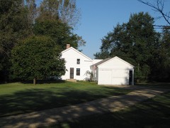
Photograph of Gray-Watkins Mill
Photograph by lester1950, CC BY-SA 3.0. Via Wikimedia Commons.

Gray-Watkins Mill

Listed on the National Register of Historic Places in 1979.

From the record

“The Gray-Watkins Mill or Gray's Mill is a historic structure in Montgomery, in the U.S. state of Illinois. The building was an early turbine mill on the Fox River, and was later used by an automobile parts manufacturer.”

Wikipedia article Gray-Watkins Mill, CC BY-SA 4.0.

One of 86 National Register listings published here for Kane County · listed in 1979 · category: Building.

Sources: the Wikipedia article · the case file at the National Archives · the National Register database, National Park Service

The listing

  • What is counted as historic. The nomination lists 1 building as contributing to the listing.
  • Address. 211 N. River St., Montgomery, 60554
  • When was it listed? December 1979
  • Category. building
  • Township. Sugar Grove township
  • National Register reference number. 79000846 - the number the National Park Service assigned this property when it was listed, and the key its nomination file is catalogued under at the National Archives.

The ground it stands on

89 words

This property stands in Sugar Grove Township. History of Kane County, Ill., published 1908 gives that township a chapter of its own.

The chapter covers the township.

Machine-read from a century-old scan, so expect the errors a machine makes: misspelled names, dropped words, stray characters.

Read the whole chapter on Sugar Grove Township - 89 words on its settlement, mills, schools and churches.

Mines and quarries near this property

7 within 5 miles

Regional context, not property-specific evidence. The federal mineral resources record lists 7 workings within 5 miles of Gray-Watkins Mill: 4 producers, 3 past producers. 4 still produce. What was taken out: Sand and Gravel, Construction, Stone, Crushed/Broken. Distance is straight-line from the map coordinates, so a quarry counted here may appear on a neighbouring settlement's page as well.

Where SiteCommodity StatusRecorded
Big Rock QuarryStone, Crushed/BrokenProducer
Unamed Limestone QuarryStone, Crushed/BrokenPast Producer
Feltes Pit No. 6Sand and Gravel, ConstructionProducer
Feltes Plant No. 7 & PitSand and Gravel, ConstructionPast Producer
Fox Ridge StoneSand and Gravel, ConstructionProducer
Fox Valley Gravel PitSand and Gravel, ConstructionPast Producer
Kane County PitSand and Gravel, ConstructionProducer

Every working recorded in Kane County

Storms near this property

28 since 2003

Regional context, not property-specific evidence. The National Weather Service names Montgomery, the town this property stands in, in 28 storm reports between 2003 and 2026: 17 thunderstorm wind, 8 hail, 2 heavy rain, 1 tornado. No death or injury is recorded in these reports. Each account below is quoted exactly as the forecast office filed it, from the NOAA Storm Events Database, and each date opens the federal record of that event.

WhenEvent Place namedHarm What the report says
April 2008HailMontgomery$5,000Several nickel to quarter size hail reports were received from Aurora. Hail damage was reported at a duplex on Johnston Drive near Jericho Road.
August 2008Thunderstorm WindMontgomery$5,000Sheet metal and insulation were torn off a soap factory by strong winds. Most of the damage was cosmetic, no structual damage was reported.
August 2008Thunderstorm WindMontgomery$1,000A 100 foot tall maple tree fell onto a house on Prairie Street. The tree broke a window and pulled off parts of a gutter.
June 2008Thunderstorm WindMontgomery$500A patio swing was picked up and thrown over a fence. Cast iron patio furniture was mangled. A trampoline was blown several houses down a street.
March 2025Thunderstorm WindMontgomery-Multiple areas with downed power lines were reported across the west side of Aurora.
July 2025Thunderstorm WindMontgomery-Numerous power lines were blown down.
July 2025Thunderstorm WindMontgomery-A photo showed a large tree limb blown down that crushed the hood of a car.
July 2025Thunderstorm WindMontgomery-Wind gusts were estimated to 60 mph.
August 2025Thunderstorm WindMontgomery-A tree and power lines were blown down on Rockwell Rd in Aurora.
August 2025Thunderstorm WindMontgomery-A tree roughly 12 to 14 feet tall and 2 to 3 feet thick fell onto a wire along Stephen Dr in Montgomery.
August 2025Thunderstorm WindMontgomery-Trees were downed onto power lines and vehicles near Prairie St and Edgelawn Dr in Aurora.
August 2025Heavy RainMontgomery-A private weather station recorded 4.94 of 24-hour rainfall, 4.46 of which fell between 2 and 6 AM CST.
April 2023HailMontgomery-Hail up to golf ball size lasted for five minutes. Numerous glass greenhouses were damaged from the hail at a garden center along Lake Street.
March 2023Tornado (EF0)Montgomery-Just a couple of minutes after touching down in far northern Kendall County, this tornado crossed into Kane County in Montgomery just west of Albright Rd. The tornado had caused minor damage to an outbuilding while still in Kendall County but most of the damage in Kane County was to trees. The tornado lifted on the south side of Aurora near the intersection of Hill Ave and Binder St.
March 2022Thunderstorm WindMontgomery-A roof of an industrial building was damaged with debris on a roadway.
August 2021Heavy RainMontgomery-Rainfall of 4.10 inches was measured in 1 hour and 47 minutes.
June 2021Thunderstorm WindMontgomery-Tree damage was reported near Galena Boulevard and Canterbury Road.
July 2019Thunderstorm WindMontgomery-Numerous power lines were blown down on Aucutt Road.
June 2013HailMontgomery-Multiple reports of hail up to the size of 1.5 inches were received between Montgomery and Aurora.
November 2013Thunderstorm WindMontgomery-Winds to 60 mph were estimated near the intersection of Orchard Road and Galena Road.
August 2007Thunderstorm WindMontgomery-Estimated winds to 65 mph.
July 2004HailMontgomery-The hail was reported at the intersection of Rt. 30 and Rt. 31.
March 2026HailMontgomery-no account filed
April 2023HailMontgomery-no account filed
March 2007Thunderstorm WindMontgomery-no account filed
May 2004Thunderstorm WindMontgomery-no account filed
August 2003HailMontgomery-no account filed

Every storm recorded in Kane County

Map coverage status

No historic map-sheet match is published for this property yet. That does not mean no map exists. This record needs a coordinate-quality review before it can be joined to a sheet boundary. Browse the county's mapped places while that work is pending.

Listed places nearby

6 within 8 miles

Other National Register properties close enough to walk or drive between, ordered by distance from this one. Both positions come from the same geocoding pass that matched these properties to their map sheets.

Photograph PropertyDistance Listed
Ephraim Smith House3.0 miles1980
Sam and Ruth Van Sickle Ford House4.4 miles
Aurora College Complex4.9 miles1984
Abraham Lincoln School5.5 miles2022
West Side Historic District6.0 miles1986
Col. Ira C. Copley Mansion6.2 miles1978

Sources for this property

National Archives recordThe nomination case file for reference 79000846 in Record Group 79.
Wikipedia articleCommunity-written account of this property, licensed CC BY-SA.
Kane CountyAll 86 listed properties in this county.

Provenance

  • Listing record. National Park Service National Register of Historic Places, listed-properties dataset, current to 2026-05-22.
  • Map join. Address geocoded through the United States Census geocoder, then tested against the published boundary of every sheet in the USGS Historical Topographic Map Collection.
  • How this page is made. Listing fields come from federal records; map-sheet coverage is a labelled coordinate-to-boundary calculation, not a source-field claim.
  • Mines and quarries. USGS Mineral Resources Data System (MRDS) https://mrdata.usgs.gov/mrds/ A work of the United States government, no copyright under 17 U.S.C. 105.
  • Storms. NOAA National Centers for Environmental Information, Storm Events Database https://www.ncei.noaa.gov/stormevents/ A work of the United States government, no copyright under 17 U.S.C. 105. Narratives are quoted verbatim from the National Weather Service report and are not edited or summarised.