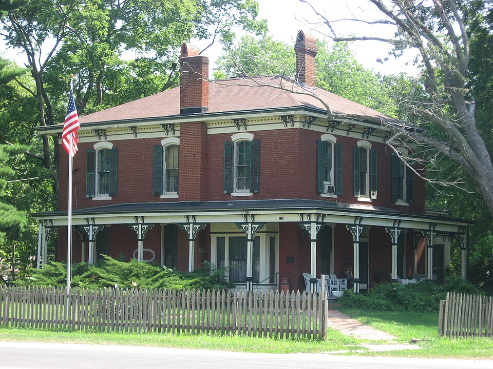
Listed on the National Register of Historic Places in 1979.
From the record
“The Calendar Rohrbough House is a historic house located at 3rd and Washington Streets in Kinmundy, Illinois. The Italianate house was built in 1875 for Calendar Rohrbough, a local merchant and politician.”
Wikipedia article Calendar Rohrbough House, CC BY-SA 4.0.
One of 9 National Register listings published here for Marion County · listed in 1979 · category: Building.
National Register reference number.79000857- the number the National Park Service assigned this property when it was listed, and the key its nomination file is catalogued under at the National Archives.
Kinmundy, a city of about fifteen hundred inhabitants, is situated on the Chicago branch of the Illinois Central Railroad. It was laid out in April, 1857, on section 22, which brings it near the center of the township. W. T. Sprouse laid out the city. Isaac Eagan laid out an addition in 1858. Other additions have been laid out from time to time. In 1895 trie Chicago & Eastern Illinois Railroad, then the Chicago, Peoria & Memphis, was built through the township, and passed through the western part of the city. The city and township are said to be named after a Scotchman, who was a stockholder in the Central when it was built, and visited this part of the county. W. B. Eagan built the first house in 1857, in which he kept a general store and was the first postmaster. The house was two stories and Eagan lived above the store. Eagan had kept a country store two or three years at the old homestead before Kinmundy was laid out. The Illinois depot was built in 1856, and like most Illinois Central depots of that day, was a big barn-like structure. Later a neat little depot was built and the old one used as a freight room. Kinmundy, like nearly all towns along the Illinois Central, is built on both sides of the railroad, and the crossing is dangerous, and deaths from being struck by trains are too often the result of this building of the towns. Several deaths at Kinmundy have resulted, among them that of Miss Cammerer, daughter of Dr. and Mrs. Cammerer, about twelve years ago. Miss Cammerer was walking with her mother, and stepping around the end of a car standing on the track, was struck by a fast train, the mother barely escaping the same fate. About the same time an entire family, except one child, were killed at the crossing at Alma. At the south side of the town Willis Wilburn built a small store room and sold goods for a time, in 1855. He built a hotel south of the present depot, about the same time. Doctor Skilling kept the first drug store, and Dr. W. W. Elliott was the first medical practitioner. Henry Eagan was the first "village blacksmith". In 1858 Sprouse built a saw and grist mill, but it was moved away in a short time, but he buit another in 1864. and in 1868 Songer Brothers built the present brick mill. It too, was moved away. Another mill was built in 1877 and passed into
The building of the Chicago & Eastern Illinois Railroad gave an impetus to business of Kinmundy, and several good brick business houses were built, but an extensive fire in 1904 destroyed about one-half of the business part of the town. It has, however, been rebuilt. A short time later another fire destroyed a large part of the remainder of the town. It too, has been rebuilt.
Regional context, not property-specific
evidence. The federal mineral resources record lists
1 working within 5 miles of Calendar Rohrbough House: 1 occurrence.
None of them still produces. What was taken out: Stone, Crushed/Broken. Distance is straight-line from the
map coordinates, so a quarry counted here may appear on a neighbouring
settlement's page as well.
Regional context, not property-specific
evidence. The National Weather Service names
Kinmundy, the town this property stands in, in 19 storm reports between 1994 and 2017: 8 thunderstorm wind, 6 hail, 4 tornado, 1 flash flood.
No death or injury is recorded in these reports. Each account below is quoted exactly as the forecast office
filed it, from the NOAA Storm Events Database, and each date
opens the federal record of that event.
Up to four inches of rain fell in a short amount of time causing flash flooding. Several roads were flooded including the intersection of Kinlou and Vandeveer Roads.
A tornado briefly touched down in a farm destroying a machine shed and flipped over an unoccupied and unanchored mobile home. Also, the farm house sustained minor roof damage and several trees were blown over.
The damaging winds persisted into northeastern Marion county. About one and a half miles southeast of Farina, another machine shed was completely destroyed by the winds with debris tossed approximately 100 yards. There was also widespread tree damage in this area as well. On Interstate 57, 3 semi tractor trailers were blown over around mile marker 133. One of the drivers sustained minor injuries and was taken to Salem Township Hospital for treatment of the injuries.
Three tornadoes caused damage near Kinmundy. The first tornado caused considerable damage to a 2 story structure near the intersection of Highway 37 and Kinoka Road. The roof and 2 walls of the structure were thrown across Highway 37 into the woods. There was also tree and power line damage along the path.
Three tornadoes caused damage near Kinmundy, Illinois. The second tornado damaged 2 homes. Over 50 percent of the roof of one home was blown 70 yards away. The rest of the damage was to trees and power lines.
Three tornadoes caused damage near Kinmundy, Illinois. The third tornado significantly damaged a mobile home. This tornado also destroyed several large trees.
No historic map-sheet match is published
for this property yet. That does not mean no map exists. This record needs
a coordinate-quality review before it can be joined to a sheet boundary.
Browse the county's mapped places while that work is
pending.
Listed places nearby
1 within 8 miles
Other National Register properties close
enough to walk or drive between, ordered by distance from this one. Both
positions come from the same geocoding pass that matched these properties
to their map sheets.
Listing record. National Park Service National Register of Historic Places, listed-properties dataset, current to 2026-05-22.
Map join. Address geocoded through the United States Census geocoder, then tested against the published boundary of every sheet in the USGS Historical Topographic Map Collection.
How this page is made. Listing fields come from federal records; map-sheet coverage is a labelled coordinate-to-boundary calculation, not a source-field claim.
Mines and quarries. USGS Mineral Resources Data System (MRDS) https://mrdata.usgs.gov/mrds/ A work of the United States government, no copyright under 17 U.S.C. 105.
Storms. NOAA National Centers for Environmental Information, Storm Events Database https://www.ncei.noaa.gov/stormevents/ A work of the United States government, no copyright under 17 U.S.C. 105. Narratives are quoted verbatim from the National Weather Service report and are not edited or summarised.
 Block