
BlockBefore
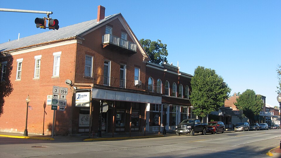
Photograph of Red Bud Historic District
Photograph by Nyttend, Public domain. Via Wikimedia Commons.

Red Bud Historic District

Listed on the National Register of Historic Places in 1979.

From the record

“The Red Bud Historic District is a commercial and residential historic district which includes the originally developed portions of Red Bud, Illinois, United States. The district is centered on Main and Market Streets, the primary roads through the city.”

Wikipedia article Red Bud Historic District, CC BY-SA 4.0.

One of 12 National Register listings published here for Randolph County · listed in 1979 · category: District.

Sources: the Wikipedia article · the case file at the National Archives · the National Register database, National Park Service

The listing

  • Address. Irregular pattern along Main and Market Sts., Red Bud, 62278
  • When was it listed? December 1979
  • Category. district
  • Precinct. Red Bud precinct
  • National Register reference number. 79000865 - the number the National Park Service assigned this property when it was listed, and the key its nomination file is catalogued under at the National Archives.

Mines and quarries near this property

4 within 5 miles

Regional context, not property-specific evidence. The federal mineral resources record lists 4 workings within 5 miles of Red Bud Historic District: 2 occurrences, 2 past producers. None of them still produces. What was taken out: Stone, Crushed/Broken. Distance is straight-line from the map coordinates, so a quarry counted here may appear on a neighbouring settlement's page as well.

Where SiteCommodity StatusRecorded
Limestone ProspectStone, Crushed/BrokenOccurrence
Unnamed Limestone QuarryStone, Crushed/BrokenPast Producer

Every working recorded in Randolph County

Storms near this property

33 since 1996

Regional context, not property-specific evidence. The National Weather Service names Red Bud, the town this property stands in, in 33 storm reports between 1996 and 2026: 21 hail, 8 thunderstorm wind, 3 flash flood, 1 tornado. The reports record 1 injury. Each account below is quoted exactly as the forecast office filed it, from the NOAA Storm Events Database, and each date opens the federal record of that event.

WhenEvent Place namedHarm What the report says
March 2009HailRed Bud1 hurtOne person sustained minor cuts when the large hail shattered a window in their home.
May 2024Thunderstorm WindRed Bud$20,000Thunderstorm winds caused a power pole to fall across a roadway and a tree to fall on a house south of Red Bud. There was minor damage to the house. Several trees and power lines were knocked down in Sparta, and there was a tree down over a roadway near Eden. Cities in the path of the storm include Baldwin and Houston.
March 2026Thunderstorm WindRed Bud-Thunderstorm winds caused snapped softwood trees and a large hardwood tree. A power pole was also snapped, and a machine shed incurred significant damage.
March 2024Thunderstorm WindRed Bud-An emergency manager reported power lines down on the south side of Red Bud, IL. No further information was given on the power lines. This was the same thunderstorm that produced golf ball sized hail in Ruma to the south.
August 2020Flash FloodRed Bud-Up to four inches of rain fell in a two hour period on already saturated soils. This caused flash flooding in northwestern portions of Randolph County. Numerous roads were flooded including Illinois Route 3 near Ruma.
November 2017HailRed Bud-Large hail was reported in a swath from Red Bud, through Baldwin, Houston and into Sparta.
July 2016Thunderstorm WindRed Bud-Thunderstorm winds blew down numerous trees, tree limbs and power lines in Red Bud, Baldwin, and Sparta.
August 2010Thunderstorm WindRed Bud-Four power poles were broken by thunderstorm wind gusts.
April 2008HailRed Bud-One inch hail caused some damage to cars in the Red Bud area. No damage estimates were available.
May 2008HailRed Bud-Numerous reports of hail from nickel to golf ball size were received from storm spotters and the general public.
May 2008Flash FloodRed Bud-Heavy rain quickly flooded local roads with as much as eight inches of water.
January 2006Thunderstorm WindRed Bud-A NWS cooperative observer reported wind damage to a grain bin and a couple of farm outbuildings.
February 2006HailRed Bud-A storm spotter reported 1 inch hail.
May 2004Thunderstorm WindRed Bud-Storm spotters reported a couple of 2 foot diameter pine trees snapped by thunderstorm winds.
July 2004HailRed Bud-Storm spotters reported 1 inch hail.
May 2003Tornado (F1)Red Bud-A small tornado caused damage over a half mile long track southeast of Red Bud. A home located just south of the intersection of Ritchfield and South Prairie Road sustained severe damage. Most of the roof was blown off and the west and south walls were severely damaged. A machine shed was destroyed and another moved off of its foundation. Several large trees in the area were snapped off near the ground.
April 1998HailRed Bud-Spotters reported golfball size hail.
May 2025HailRed Bud-no account filed
February 2017HailRed Bud-no account filed
May 2016HailRed Bud-no account filed
June 2011HailRed Bud-no account filed
October 2010HailRed Bud-no account filed
April 2007HailRed Bud-no account filed
March 2006HailRed Bud-no account filed
May 2006HailRed Bud-no account filed
July 2001Flash FloodRed Bud-no account filed
June 1996Thunderstorm WindRed Bud-no account filed
May 1996HailRed Bud-no account filed

Every storm recorded in Randolph County

Map coverage status

No historic map-sheet match is published for this property yet. That does not mean no map exists. This record needs a coordinate-quality review before it can be joined to a sheet boundary. Browse the county's mapped places while that work is pending.

Sources for this property

National Archives recordThe nomination case file for reference 79000865 in Record Group 79.
Wikipedia articleCommunity-written account of this property, licensed CC BY-SA.
Randolph CountyAll 12 listed properties in this county.

Provenance

  • Listing record. National Park Service National Register of Historic Places, listed-properties dataset, current to 2026-05-22.
  • Map join. Address geocoded through the United States Census geocoder, then tested against the published boundary of every sheet in the USGS Historical Topographic Map Collection.
  • How this page is made. Listing fields come from federal records; map-sheet coverage is a labelled coordinate-to-boundary calculation, not a source-field claim.
  • Mines and quarries. USGS Mineral Resources Data System (MRDS) https://mrdata.usgs.gov/mrds/ A work of the United States government, no copyright under 17 U.S.C. 105.
  • Storms. NOAA National Centers for Environmental Information, Storm Events Database https://www.ncei.noaa.gov/stormevents/ A work of the United States government, no copyright under 17 U.S.C. 105. Narratives are quoted verbatim from the National Weather Service report and are not edited or summarised.