BlockBefore
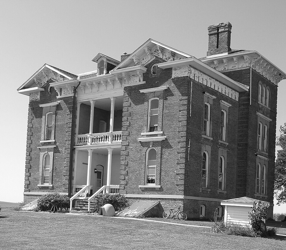
Photograph of Duncan Manor
Photograph by Greerje at en.wikipedia, Public domain. Via Wikimedia Commons.

Duncan Manor

Listed on the National Register of Historic Places in 1979.

From the record

“Duncan Manor is a historic house located in rural McLean County, Illinois, near Towanda. The house was built circa 1866 for William R.”

Wikipedia article Duncan Manor, CC BY-SA 4.0.

One of 35 National Register listings published here for McLean County · listed in 1979 · category: Building.

Sources: the Wikipedia article · the case file at the National Archives · the National Register database, National Park Service
The listing

  • What is counted as historic. The nomination lists 1 building as contributing to the listing.
  • Address. SW of Towanda off IL 4, Towanda, 61776
  • When was it listed? February 1979
  • Category. building
  • Township. Towanda township
  • Architectural style. Italianate architecture
  • National Register reference number. 79003164 - the number the National Park Service assigned this property when it was listed, and the key its nomination file is catalogued under at the National Archives.

The ground it stands on

15,602 words

The chapter on Towanda Township in The Good Old Times in McLean County, Illinois : Containing Two Hundred and Sixty-one Sketches of Old Settlers, a Complete Historical Sketch of the Black Hawk War and Descriptions of All Matters of Interest Relating to McLean County, published 1874; The History of McLean County, Illinois; Portraits of Early Settlers and Prominent Men, published 1879 names Towanda. This is what it says, exactly as the scans read.

He lived on his claim, near the present Trimmer place, for three years, then three years in Mackinaw timber, then three years at Randolph's Grove, and then moved to Smith's Grove, about three miles from the present village of Towanda, and there he has lived ever since. The great sudden change in the weather took place in December, 1836, while Mr. Walden lived at Mackinaw timber. He was about a mile and a-half from home, but jumped on his horse and started on the full run, the intense cold freezing the slush as he traveled. As he passed a slough near his house he saw a lot of pigs belonging to his neighbor Bartholomew, frozen last in it. AVhen he arrived home, he could scarcely pull oil' his overcoat as it was frozen fast. Mr. Bartholomew was obliged to chop his pigs loose from the ice to get them out. During this sudden change, "William Walden, the brother of Jesse, came across the prairie on foot, and the water plashed on his trousers and froze on them so rapidly that he was obliged to cut off his pantaloons below the knee in order to travel. He was driving an ox-team and had a friend with him who wished to resign himself to fate and die, but William pitched the man into the wagon and brought him home.

Passage source: The Good Old Times in McLean County, Illinois : Containing Two Hundred and Sixty-one Sketches of Old Settlers, a Complete Historical Sketch of the Black Hawk War and Descriptions of All Matters of Interest Relating to McLean County, published 1874.

Towanda is pleasantly located on the prairie, less than a mile southwest of Money Creek. The village is on high land, and, judging from its location and the number of its physicians, is a very healthy place in which to live. It is situated on the Chicago, Alton & St. Louis Railroad, about half way between Bloomington and Lexington. The railroad enters the village at the southwest corner, and passes in a northeasterly direction through it. It is surrounded by a good farming and grazing country, and has all the natural facilities for a flourishing inland town. It would have grown much more rapidly, no doubt, had it not been so near to our ambitious county seat, whose shadow reaches far out into the surrounding country, chilling the young life-blood in many smaller towns. The population of Towanda, at present, is about 500.

Passage source: The History of McLean County, Illinois; Portraits of Early Settlers and Prominent Men, published 1879.

Machine-read from a century-old scan, so expect the errors a machine makes: misspelled names, dropped words, stray characters.

Read the whole chapter on Towanda Township - 15,602 words on its settlement, mills, schools and churches.

Fires near this property

1 since 2013

Regional context, not property-specific evidence. The federal wildfire occurrence database lists 1 fire within 5 miles of Duncan Manor in 2013, burning under an acre in total. None started naturally. None was recorded as arson. Distance is straight-line from the map coordinates, so a fire counted here may appear on a neighbouring settlement's page as well.

Reported cause Fires
Missing data/not specified/undetermined1

The most recent of them, most recent first, with the day each was reported and the service that recorded it.

DateCause SizeReported by Name on the report
15 September 2013Missing data/not specified/undeterminedunder an acreIllinois Division of Forestry Resources2013-1467

Every fire recorded in McLean County

Storms near this property

12 since 1994

Regional context, not property-specific evidence. The National Weather Service names Towanda, the town this property stands in, in 12 storm reports between 1994 and 2025: 6 thunderstorm wind, 5 hail, 1 tornado. No death or injury is recorded in these reports. Each account below is quoted exactly as the forecast office filed it, from the NOAA Storm Events Database, and each date opens the federal record of that event.

WhenEvent Place namedHarm What the report says
July 2020Thunderstorm WindTowanda$80,000Numerous trees and tree branches were blown down, including a branch that brought power lines down and caused a fire at a house on North Street. Crops were flattened by strong thunderstorm winds as well.
June 2010Thunderstorm WindTowanda$20,000A large tree was blown onto a house.
May 2007Thunderstorm WindTowanda$7,000Several healthy 12 inch diameter trees were blown down.|
June 2010Thunderstorm WindTowanda$2,000A large maple tree was blown down.
July 2025Thunderstorm WindTowanda-Heavy tree damage occurred in Towanda. County Highway 29 was blocked off from tree debris.
November 2022Thunderstorm WindTowanda-A 65mph thunderstorm wind gust was measured near Towanda.
May 2014HailTowanda-Hail lasted for 3 minutes.
April 2006Tornado (F0)Towanda-The tornado briefly touched down in a field. No damage was reported.
May 2014HailTowanda-no account filed
June 2009HailTowanda-no account filed
July 2004HailTowanda-no account filed
April 1994HailTowanda-no account filed

Every storm recorded in McLean County

Map coverage status

No historic map-sheet match is published for this property yet. That does not mean no map exists. This record needs a coordinate-quality review before it can be joined to a sheet boundary. Browse the county's mapped places while that work is pending.

Listed places nearby

6 within 8 miles

Other National Register properties close enough to walk or drive between, ordered by distance from this one. Both positions come from the same geocoding pass that matched these properties to their map sheets.

Photograph PropertyDistance Listed
Gildersleeve House4.8 miles1977
Children's Village-Illinois Soldiers' and Sailors' Children's School4.9 miles2018
Hubbard House4.9 miles1979
Sprague's Super Service5.1 miles2008
Fairview Sanatorium5.6 miles2021
Normal Theater5.8 miles1997

Sources for this property

National Archives recordThe nomination case file for reference 79003164 in Record Group 79.
Wikipedia articleCommunity-written account of this property, licensed CC BY-SA.
McLean CountyAll 35 listed properties in this county.

Provenance

  • Listing record. National Park Service National Register of Historic Places, listed-properties dataset, current to 2026-05-22.
  • Map join. Address geocoded through the United States Census geocoder, then tested against the published boundary of every sheet in the USGS Historical Topographic Map Collection.
  • How this page is made. Listing fields come from federal records; map-sheet coverage is a labelled coordinate-to-boundary calculation, not a source-field claim.
  • Wildfire. Short, Karen C. 2022. Spatial wildfire occurrence data for the United States, 1992-2020 [FPA_FOD_20221014]. 6th Edition. Fort Collins, CO: Forest Service Research Data Archive. https://doi.org/10.2737/RDS-2013-0009.6 Collected with United States Government funding and usable without additional permissions or fees.
  • Storms. NOAA National Centers for Environmental Information, Storm Events Database https://www.ncei.noaa.gov/stormevents/ A work of the United States government, no copyright under 17 U.S.C. 105. Narratives are quoted verbatim from the National Weather Service report and are not edited or summarised.