BlockBefore
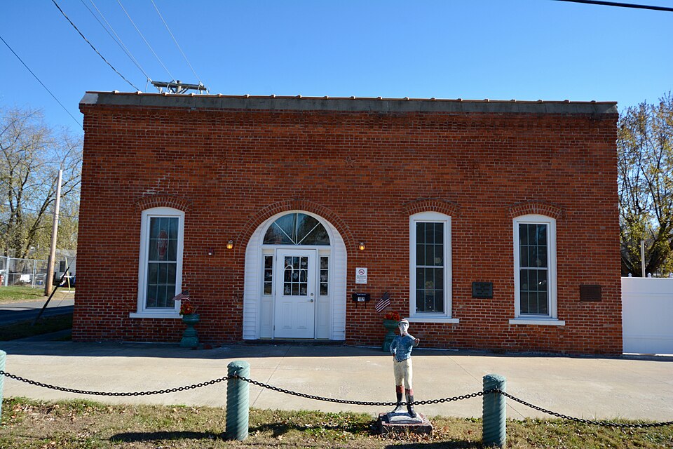
Photograph of White Hall Foundry
Photograph by Boscophotos, CC BY-SA 3.0. Via Wikimedia Commons.

White Hall Foundry

Listed on the National Register of Historic Places in 1980.

From the record

“The White Hall Foundry is a historic iron foundry located at 102 S. Jacksonville St. in White Hall, Illinois.”

Wikipedia article White Hall Foundry, CC BY-SA 4.0.

One of 12 National Register listings published here for Greene County · listed in 1980 · category: Building.

Sources: the Wikipedia article · the case file at the National Archives · the National Register database, National Park Service

The listing

  • What is counted as historic. The nomination lists 1 building as contributing to the listing.
  • Address. 102 S. Jacksonville St., White Hall, 62092
  • When was it listed? May 1980
  • Category. building
  • Township. White Hall township
  • National Register reference number. 80001365 - the number the National Park Service assigned this property when it was listed, and the key its nomination file is catalogued under at the National Archives.

The ground it stands on

37,197 words

The chapter on White Hall Township in History of Greene County, Illinois : Its Past and Present, Containing a History of the County ; Its Cities, Towns, Etc. ; a Biographical Directory of Its Citizens ; War Record.., published 1879 names White Hall. This is what it says, exactly as the scans read.

White Hall, one of the most flourishing towns in Southern Illinois, whose tile, sewer pipe and pottery finds its way all over the Union, was founded by David Barrow, on the 12th day of January, 1832. The town plat which was recorded March 9, 1832, in the presence of J. J. Cavell, a justice of the peace, reveals the fact that White Hall was laid out on the southeast corner of section 35, in township 12, north of range 12 west The plat was surveyed by Jeremiah Smith, Deputy Surveyor of Greene County, and contained forty-eight lots and four streets, known as West street. East street, Main street, and Church street.

Passage source: History of Greene County, Illinois : Its Past and Present, Containing a History of the County ; Its Cities, Towns, Etc. ; a Biographical Directory of Its Citizens ; War Record.., published 1879.

The first settlements in townsliip 12, r. 12, in which White Hall is situated, were probably made about the 3^ear 1820. About that time came Charles Kitchen, afterward a Baptist minister, Lewis Roberts, John Thompson, and others. The next year we hear of the arrival of Absalom Frames and William Hudson.

Passage source: History of Greene County, Illinois : Its Past and Present, Containing a History of the County ; Its Cities, Towns, Etc. ; a Biographical Directory of Its Citizens ; War Record.., published 1879.

Machine-read from a century-old scan, so expect the errors a machine makes: misspelled names, dropped words, stray characters.

Read the whole chapter on White Hall Township - 37,197 words on its settlement, mills, schools and churches.

Mines and quarries near this property

2 within 5 miles

Regional context, not property-specific evidence. The federal mineral resources record lists 2 workings within 5 miles of White Hall Foundry: 1 producer, 1 past producer. 1 still produces. What was taken out: Stone, Crushed/Broken, Clay. Distance is straight-line from the map coordinates, so a quarry counted here may appear on a neighbouring settlement's page as well.

Where SiteCommodity StatusRecorded
Purington Clay Shale PitClayPast Producer
Valstad Quarry #1Stone, Crushed/BrokenProducer

Every working recorded in Greene County

Storms near this property

29 since 1995

Regional context, not property-specific evidence. The National Weather Service names White Hall, the town this property stands in, in 29 storm reports between 1995 and 2024: 13 thunderstorm wind, 13 hail, 1 tornado, 1 funnel cloud. No death or injury is recorded in these reports. Each account below is quoted exactly as the forecast office filed it, from the NOAA Storm Events Database, and each date opens the federal record of that event.

WhenEvent Place namedHarm What the report says
August 2006Thunderstorm WindWhite Hall$10,000The County Sheriff reported large tree limbs down. One fell on and damaged a home.
August 2021Thunderstorm WindWhite Hall$5,000Thunderstorm winds blew down several power lines around town as well as numerous tree limbs.
July 1995Thunderstorm WindWhite Hall$300Wind gusts reached 60 mph with several large trees blown down.
May 1995Tornado (F1)White Hall$145The Illinois State Police and storm spotters followed a tornado from the White Hall area to near Manchester. The tornado lifted off the ground at times but did damage several farm buildings and trees as it traveled nearly parallel to Highway 267.
April 2024HailWhite Hall-Large hail up to 1.75 inches was reported in White Hall and Roodhouse.
May 2019Thunderstorm WindWhite Hall-Thunderstorm winds blew down several trees and power lines around town, as well as numerous tree limbs.
May 2016Thunderstorm WindWhite Hall-Thunderstorm winds blew down several large trees and power lines around town.
June 2014Flash FloodWhite Hall-Up to 4 inches of rain fell in a short amount of time causing flash flooding. The town of Hillview became isolated as all the roads travelling into town were impassable due to flooding from Hurricane Creek. A number of homes in town had water in them.
July 2010Thunderstorm WindWhite Hall-Thunderstorm winds blew down numerous large tree limbs around town. Also, several power lines were blown down.
August 2007Thunderstorm WindWhite Hall-Numerous tree limbs were blown down.
August 2004Funnel CloudWhite Hall-A storm spotter reported a funnel cloud southwest of White Hall.
August 2003HailWhite Hall-The Sheriff Department reported 3/4 inch hail in White Hall.
June 2002Thunderstorm WindWhite Hall-Thunderstorm wind gusts downed trees and power lines.
May 2000Thunderstorm WindWhite Hall-Thunderstorm wind gusts caused damage across much of White Hall. Numerous trees and power lines were down with virtually the entire town without power for at least 4 hours. One small home was destroyed when a large tree fell on it. Numerous vehicles were damaged by falling trees as well.
April 2000HailWhite Hall-Hail up to golfball size was reported from White Hall to Roodhouse .
June 2000Thunderstorm WindWhite Hall-The local newspaper reported trees down in White Hall.
August 2000Thunderstorm WindWhite Hall-Local law enforcement reported trees and power lines down.
April 2012HailWhite Hall-no account filed
April 2010HailWhite Hall-no account filed
June 2008HailWhite Hall-no account filed
March 2006HailWhite Hall-no account filed
May 2003HailWhite Hall-no account filed
April 2002HailWhite Hall-no account filed
June 1998HailWhite Hall-no account filed
November 1998Thunderstorm WindWhite Hall-no account filed
June 1998Thunderstorm WindWhite Hall-no account filed
December 1996HailWhite Hall-no account filed

Every storm recorded in Greene County

Map coverage status

No historic map-sheet match is published for this property yet. That does not mean no map exists. This record needs a coordinate-quality review before it can be joined to a sheet boundary. Browse the county's mapped places while that work is pending.

Listed places nearby

5 within 8 miles

Other National Register properties close enough to walk or drive between, ordered by distance from this one. Both positions come from the same geocoding pass that matched these properties to their map sheets.

Photograph PropertyDistance Listed
White Hall Historic District0.3 miles1987
White Hall Historic District (Boundary Increase)0.4 miles1993
Virginia Tillery Round Barn1.9 miles1982
Hotel Roodhouse3.5 miles1995
Greene County Almshouse7.6 miles1991

Sources for this property

National Archives recordThe nomination case file for reference 80001365 in Record Group 79.
Wikipedia articleCommunity-written account of this property, licensed CC BY-SA.
Greene CountyAll 12 listed properties in this county.

Provenance

  • Listing record. National Park Service National Register of Historic Places, listed-properties dataset, current to 2026-05-22.
  • Map join. Address geocoded through the United States Census geocoder, then tested against the published boundary of every sheet in the USGS Historical Topographic Map Collection.
  • How this page is made. Listing fields come from federal records; map-sheet coverage is a labelled coordinate-to-boundary calculation, not a source-field claim.
  • Mines and quarries. USGS Mineral Resources Data System (MRDS) https://mrdata.usgs.gov/mrds/ A work of the United States government, no copyright under 17 U.S.C. 105.
  • Storms. NOAA National Centers for Environmental Information, Storm Events Database https://www.ncei.noaa.gov/stormevents/ A work of the United States government, no copyright under 17 U.S.C. 105. Narratives are quoted verbatim from the National Weather Service report and are not edited or summarised.