BlockBefore

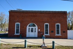
Hotel Roodhouse

Listed on the National Register of Historic Places in 1995.

From the record

“The Hotel Roodhouse was a historic hotel located at 303 Morse St. in Roodhouse, Illinois. John Roodhouse, the founder of the city, opened the hotel in 1895.”

Wikipedia article Hotel Roodhouse, CC BY-SA 4.0.

One of 12 National Register listings published here for Greene County · listed in 1995 · category: Building.

Sources: the Wikipedia article · the case file at the National Archives · the National Register database, National Park Service


The listing

  • What is counted as historic. The nomination lists 1 building as contributing to the listing.
  • Address. 303 Morse St., Roodhouse, 62082
  • When was it listed? November 1995
  • Category. building
  • Township. Roodhouse township
  • Architectural style. Queen Anne style architecture in the United States, Romanesque Revival architecture
  • National Register reference number. 95001238 - the number the National Park Service assigned this property when it was listed, and the key its nomination file is catalogued under at the National Archives.

What happened here

An account from the chapter on Roodhouse township. The inset identifies its exact source book and publication year.

From History of Greene County, Illinois : Its Past and Present, Containing a History of the County ; Its Cities, Towns, Etc. ; a Biographical Directory of Its Citizens ; War Record.., published 1879 - Roodhouse Township

Wolf Scalps

Any person claiming a bounty shall produce the scalp or scalps with the ears thereon, within sixty days after the wolf or wolves shall have been caught, to the Clerk of the County Board, who shall administer to said person the following oath or aflBrmation, to-wit: "You do solemnly swear (or affirm, as the case may be), that the scalp or scalps here produced by you was taken from a wolf or wolves killed and first captured by yourself within the limits of this county, and within the sixty dayslast past."

Read the rest of this passage

The ground it stands on

85,575 words

The chapter on Roodhouse Township in History of Greene County, Illinois : Its Past and Present, Containing a History of the County ; Its Cities, Towns, Etc. ; a Biographical Directory of Its Citizens ; War Record.., published 1879 names Roodhouse. This is what it says, exactly as the scans read.

It was in 1819 that Benjamin Drummond came from Madison County, to the northern part of this county, near wliere Roodhouse is now situated. Dr. Thaxton, Jesse Allen, Jesse Morrow, William Waltrip, William Thaxton, Larkin Thaxton, and others, are also set down as arriving during 1819. This was i-eally the first year during which immigration was at all brisk. The country was rapidly filling up and the red man was almost entirely banished, and rapid growth and improvement were the order of the day.

Passage source: History of Greene County, Illinois : Its Past and Present, Containing a History of the County ; Its Cities, Towns, Etc. ; a Biographical Directory of Its Citizens ; War Record.., published 1879.

The winter of 1819 and '20 proved to be an unusually severe one. The long grass of the prairies had been destroyed by fires lighted by the Indians "or hunters, and much of the undergrowth in the woods was killed by the same element. Before the close of the winter, the provisions gathered by them for their stock, from places where it had escaped the ravages of the fire, gave out and they were compelled to cut down trees, from the boughs of which the cattle and horses could procure a scanty supply of food. Many of these wandered away and were lost, while some of ^tliem died from the effects of cold and hunger. The supply of food for themselves and families proved to be sufficient, yet their suffering from the cold was often intense. Mr. Seymour Kellogg, who lived in the Mauvaisterre settlement, in his search for some of his stock, one bitterly cold night, lost his way and saved his life only by walking vigorously'between two trees standing several rods apart. He did not dare to leave this track during the night for fear of being irrecoverably lost. He did not know how far he was from either his own or his brother's cabin. On the appearance of daylight, he found himself about two miles from the latter place, to which he immediately repaired. His feet were badly frozen during the night, making him a cripple for several months. Notwithstanding these hardships, the residents of the county were not discouraged, l)ut went to work in the Spring with renewed vigor. We hear of very large accessions to the population of the county, in 1820, and important strides were made forward. Immigrants poured in from nearly every direction, and almost every township in the county contained one or more families before the close of the year. Among those whom we find recorded as arrivinii' during this year are Jacob Bowman, Martin Bowman, Silas Eldred and Mrs. Ruth Eldred, soutli and west of Carrollton ; John Greene and James Whitlock, near Kane ; John Lorton, Robert Lorton, Thomas Lorton and Isaac Hill, in the northern part of the county: Ransom and Jesse Flatt, near the Illinois River; Zachariah Allen, James Allen, and David Battle, west of Wrightsville ; Isaac Norton, south of White Hall ; Charles Kitchen, Lewis Roberts and Jolm Thompson, near Roodhouse ; David and James Pinkerton, on tlie pranie named after them ; William J. Brown, east of Carrollton ; Benjamin Taylor and Isaac Taylor, on tlie prairie near Rockbridge. ''Old Benny Taylor," as he was called, was the first settler on Taylor's prairie. Soon after liim came Isaac Taylor with his two sons

Passage source: History of Greene County, Illinois : Its Past and Present, Containing a History of the County ; Its Cities, Towns, Etc. ; a Biographical Directory of Its Citizens ; War Record.., published 1879.

Machine-read from a century-old scan, so expect the errors a machine makes: misspelled names, dropped words, stray characters.

Read the whole chapter on Roodhouse Township - 85,575 words on its settlement, mills, schools and churches.

Mines and quarries near this property

1 within 5 miles

Regional context, not property-specific evidence. The federal mineral resources record lists 1 working within 5 miles of Hotel Roodhouse: 1 past producer. None of them still produces. What was taken out: Clay. Distance is straight-line from the map coordinates, so a quarry counted here may appear on a neighbouring settlement's page as well.

Where SiteCommodity StatusRecorded
Purington Clay Shale PitClayPast Producer

Every working recorded in Greene County

Storms near this property

21 since 1994

Regional context, not property-specific evidence. The National Weather Service names Roodhouse, the town this property stands in, in 21 storm reports between 1994 and 2024: 13 thunderstorm wind, 7 hail, 1 tornado. No death or injury is recorded in these reports. Each account below is quoted exactly as the forecast office filed it, from the NOAA Storm Events Database, and each date opens the federal record of that event.

WhenEvent Place namedHarm What the report says
June 1994Thunderstorm WindRoodhouse$500A second thunderstorm knocked power lines and poles down and produced pea-size hail. Reported by a local newspaper.
July 1995TornadoRoodhouse$200A slow moving tornado touched down between Roodhouse and White Hall. It remained on the ground for about 10 minutes and damaged crops in fields along Highway 267.
May 2024HailRoodhouse-A photo on Twitter showed a measured golf ball sized hailstone.
May 2020Thunderstorm WindRoodhouse-Thunderstorm winds caused minor roof damage to a residence about 2 miles northeast of Roodhouse.
July 2008Thunderstorm WindRoodhouse-Numerous tree limbs and a couple of power lines were blown down in Roodhouse and areas just to the east of Roodhouse.
August 2007Thunderstorm WindRoodhouse-Numerous tree limbs were blown down and some corn was flattened in several fields. One house east of Roodhouse had a few shingles blown off its roof.
July 2006Thunderstorm WindRoodhouse-Thunderstorm winds blew a fire truck of the road 2 miles east of Roodhouse. No injuries were reported.
May 2004Thunderstorm WindRoodhouse-Local law enforcement reported power lines down in Roodhouse.
April 2003HailRoodhouse-The County Sheriff reported 3/4 inch hail.
September 2000Thunderstorm WindRoodhouse-Roodhouse Police reported trees and power lines down.
June 1994HailRoodhouse-The Roodhouse Police Department reported hail the size of half dollars.
March 2017Thunderstorm WindRoodhouse-no account filed
April 2011Thunderstorm WindRoodhouse-no account filed
April 2011HailRoodhouse-no account filed
January 2008HailRoodhouse-no account filed
January 2008Thunderstorm WindRoodhouse-no account filed
April 2006HailRoodhouse-no account filed
May 2003Thunderstorm WindRoodhouse-no account filed
April 2002HailRoodhouse-no account filed
August 1999Thunderstorm WindRoodhouse-no account filed
June 1999Thunderstorm WindRoodhouse-no account filed

Every storm recorded in Greene County

Map coverage status

No historic map-sheet match is published for this property yet. That does not mean no map exists. This record needs a coordinate-quality review before it can be joined to a sheet boundary. Browse the county's mapped places while that work is pending.

Listed places nearby

4 within 8 miles

Other National Register properties close enough to walk or drive between, ordered by distance from this one. Both positions come from the same geocoding pass that matched these properties to their map sheets.

Photograph PropertyDistance Listed
White Hall Historic District3.3 miles1987
White Hall Historic District (Boundary Increase)3.3 miles1993
White Hall Foundry3.5 miles1980
Virginia Tillery Round Barn4.3 miles1982

Sources for this property

National Archives recordThe nomination case file for reference 95001238 in Record Group 79.
Wikipedia articleCommunity-written account of this property, licensed CC BY-SA.
Greene CountyAll 12 listed properties in this county.

Provenance

  • Listing record. National Park Service National Register of Historic Places, listed-properties dataset, current to 2026-05-22.
  • Map join. Address geocoded through the United States Census geocoder, then tested against the published boundary of every sheet in the USGS Historical Topographic Map Collection.
  • How this page is made. Listing fields come from federal records; map-sheet coverage is a labelled coordinate-to-boundary calculation, not a source-field claim.
  • Mines and quarries. USGS Mineral Resources Data System (MRDS) https://mrdata.usgs.gov/mrds/ A work of the United States government, no copyright under 17 U.S.C. 105.
  • Storms. NOAA National Centers for Environmental Information, Storm Events Database https://www.ncei.noaa.gov/stormevents/ A work of the United States government, no copyright under 17 U.S.C. 105. Narratives are quoted verbatim from the National Weather Service report and are not edited or summarised.