BlockBefore
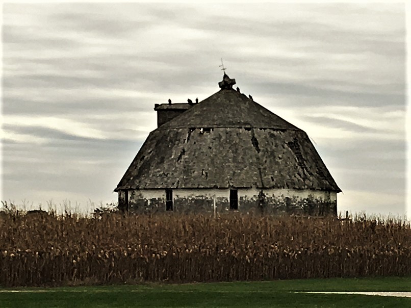
Photograph of Clarence Kleinkopf Round Barn
Photograph by Jon Roanhaus, CC BY-SA 4.0. Via Wikimedia Commons.

Clarence Kleinkopf Round Barn

Listed on the National Register of Historic Places in 1982.

From the record

“The Clarence Kleinkopf Round Barn is a round barn in McDonough County, Illinois, United States. Carpenter Dick Carmack built the barn in 1915 for farmer George Welch.”

Wikipedia article Clarence Kleinkopf Round Barn, CC BY-SA 4.0.

One of 8 National Register listings published here for McDonough County · listed in 1982 · category: Building.

Sources: the Wikipedia article · the case file at the National Archives · the National Register database, National Park Service
The listing

  • What is counted as historic. The nomination lists 1 building as contributing to the listing.
  • Listed as. Kleinkopf, Clarence, Round Barn - the National Register files a house under its owner's surname.
  • Address. N of Colchester, Colchester, 62326
  • When was it listed? August 1982
  • Category. building
  • Also known as. Round Barns in Illinois TR
  • Township. Colchester township
  • National Register reference number. 82002586 - the number the National Park Service assigned this property when it was listed, and the key its nomination file is catalogued under at the National Archives.

Fires near this property

1 since 2008

Regional context, not property-specific evidence. The federal wildfire occurrence database lists 1 fire within 5 miles of Clarence Kleinkopf Round Barn in 2008, burning about 25 acres in total. None started naturally. None was recorded as arson. Distance is straight-line from the map coordinates, so a fire counted here may appear on a neighbouring settlement's page as well.

Reported cause Fires
Debris and open burning1

The most recent of them, most recent first, with the day each was reported and the service that recorded it.

DateCause SizeReported by Name on the report
5 April 2008Debris and open burning25 acresIllinois Division of Forestry ResourcesSILBERER

Every fire recorded in McDonough County

Mines and quarries near this property

5 within 5 miles

Regional context, not property-specific evidence. The federal mineral resources record lists 5 workings within 5 miles of Clarence Kleinkopf Round Barn: 3 producers, 2 past producers. 3 still produce. What was taken out: Clay, Stone, Crushed/Broken. Distance is straight-line from the map coordinates, so a quarry counted here may appear on a neighbouring settlement's page as well.

Where SiteCommodity StatusRecorded
Colchester Plant No. 1 & MineStone, Crushed/BrokenProducer
Mc Clure QuarriesStone, Crushed/BrokenProducer
Colchester Brick & Tile Co.Clay PitClayPast Producer
Colchester PitClayPast Producer
Valentine Welch & Booz PitClayProducer

Every working recorded in McDonough County

Storms near this property

33 since 1993

Regional context, not property-specific evidence. The National Weather Service names Colchester, the town this property stands in, in 33 storm reports between 1993 and 2025: 15 hail, 14 thunderstorm wind, 3 flash flood, 1 heavy rain. No death or injury is recorded in these reports. Each account below is quoted exactly as the forecast office filed it, from the NOAA Storm Events Database, and each date opens the federal record of that event.

WhenEvent Place namedHarm What the report says
July 2003Thunderstorm WindColchester$40,000Trees down
June 2010Thunderstorm WindColchester$25,000Wind gusts estimated to be 70 mph blew a large tree down onto a house in Colchester, IL around 705 pm June 21.
June 2003Thunderstorm WindColchester$20,000Power lines down
August 1993Thunderstorm WindColchester$500Several 8-inch diameter trees were blown down 2 miles south of Colchester. A large tree was blown down at Industry.
July 2000Thunderstorm WindColchester$250Law enforcement reported a large tree limb down on Route 136.
July 2025Flash FloodColchester-Broadcast Media 3-4 inches of standing water in yards and side streets. Ditches have begun overflowing onto side streets.
June 2021Thunderstorm WindColchester-A tree was also reported down.
June 2019Thunderstorm WindColchester-A trained spotter reported that Colchester Illinois was without power. There was also pea sized hail. The time of the event was estimated using radar.
May 2015HailColchester-Mostly dime sized hail fell with a few quarter sized hail stones. Time is estimated from radar.
June 2014Thunderstorm WindColchester-A trained spotter reported small tree limbs down.
June 2014Thunderstorm WindColchester-A trained spotter estimated 58 mph winds.
June 2014Thunderstorm WindColchester-A trained spotter reported 1 to 3 inch diameter tree limbs down. A nearby home weather station reported a peak wind gust of 56 mph.
June 2011Thunderstorm WindColchester-Wind gusts estimated to be 70 mph uprooted a 20 inch diameter, 18 foot tall tree in Colchester, IL around 215 am CDT June 27.
June 2011Thunderstorm WindColchester-Wind gusts estimated to be 70 mph snapped an 18 inch diameter tree off at the base in Colchester, IL around 220 am CDT June 27. Some power lines were also downed resulting in a power outage in Colchester.
July 2010Flash FloodColchester-Heavy rains of 1.50 inches in under an hour resulted in flash flooding of some streets in Colchester, IL during the late morning of July 19.
June 2007Flash FloodColchester-Many county roads in northern McDonough County were covered by 4-6 inches of water.
March 2006HailColchester-Dime to nickel sized hail
May 2006Heavy RainColchester-1.05 inches of rain in 45 minutes
June 2006HailColchester-dime size hail
March 1998Thunderstorm WindColchester-Winds were measured 6 miles north of Argyle Lake State Park.
April 1998HailColchester-Heavy rain and hail from 3/4 to 1 inch in diameter fell over open farm land. No damage was reported.
April 1995HailColchester-Thunderstorms produced large amounts of hail, and large sized hail during this event. Hail ranged in size from dime to golf ball. A combination of ice, wind, rain, and hail wreaked havoc across parts of northwest Illinois. Hardest hit from the storms appeared to be northeast Carroll County where winds nearing 50 mph combined with ice to cause a domino effect as six power poles toppled on Illinois 73 between Payne and Spring Valley roads.
March 2024HailColchester-no account filed
August 2022HailColchester-no account filed
April 2020HailColchester-no account filed
May 2015HailColchester-no account filed
April 2013HailColchester-no account filed
May 1998Thunderstorm WindColchester-no account filed
May 1998HailColchester-no account filed
April 1996HailColchester-no account filed

Every storm recorded in McDonough County

Map coverage status

No historic map-sheet match is published for this property yet. That does not mean no map exists. This record needs a coordinate-quality review before it can be joined to a sheet boundary. Browse the county's mapped places while that work is pending.

Listed places nearby

6 within 8 miles

Other National Register properties close enough to walk or drive between, ordered by distance from this one. Both positions come from the same geocoding pass that matched these properties to their map sheets.

Sources for this property

National Archives recordThe nomination case file for reference 82002586 in Record Group 79.
Wikipedia articleCommunity-written account of this property, licensed CC BY-SA.
McDonough CountyAll 8 listed properties in this county.

Provenance

  • Listing record. National Park Service National Register of Historic Places, listed-properties dataset, current to 2026-05-22.
  • Map join. Address geocoded through the United States Census geocoder, then tested against the published boundary of every sheet in the USGS Historical Topographic Map Collection.
  • How this page is made. Listing fields come from federal records; map-sheet coverage is a labelled coordinate-to-boundary calculation, not a source-field claim.
  • Wildfire. Short, Karen C. 2022. Spatial wildfire occurrence data for the United States, 1992-2020 [FPA_FOD_20221014]. 6th Edition. Fort Collins, CO: Forest Service Research Data Archive. https://doi.org/10.2737/RDS-2013-0009.6 Collected with United States Government funding and usable without additional permissions or fees.
  • Mines and quarries. USGS Mineral Resources Data System (MRDS) https://mrdata.usgs.gov/mrds/ A work of the United States government, no copyright under 17 U.S.C. 105.
  • Storms. NOAA National Centers for Environmental Information, Storm Events Database https://www.ncei.noaa.gov/stormevents/ A work of the United States government, no copyright under 17 U.S.C. 105. Narratives are quoted verbatim from the National Weather Service report and are not edited or summarised.