 Block
From the record
8 National Register listings published here.
Sources: the county history on the Internet Archive · the National Register database, National Park Service
57 topographic sheets cover 28 settlements here, and 8 properties are on the National Register of Historic Places.
8 National Register listings published here.
Sources: the county history on the Internet Archive · the National Register database, National Park Service
Every property in this county listed on the National Register of Historic Places, with the year it was listed and the federal nomination document.
| Photograph | Property | Type | Listed | Reference |
|---|---|---|---|---|
 | William S. Bailey House | building | 2012 | 12000553 |
 | Moses King Brick and Tile Works | district | 2001 | 01000866 |
 | Clarence Kleinkopf Round Barn | building | 1982 | 82002586 |
 | Lamoine Hotel | building | 2010 | 10000760 |
 | Macomb Courthouse Square historic District | district | 2013 | 13000295 |
 | McDonough County Courthouse | building | 1972 | 72001448 |
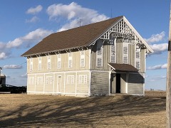 | Welling-Everly Horse Barn | building | 1985 | 85001911 |
| Western Illinois State Normal School Building | building | 1998 | 98000470 |
Every wildfire the federal occurrence database records inside this county: 6 of them, burning about 44 acres. 1 started naturally and none was recorded as arson. Each settlement page carries the fires within five miles of it.
| Reported cause | Fires |
|---|---|
| Debris and open burning | 5 |
| Natural | 1 |
The five largest, by the area the report gives. None of them was recorded as arson.
| Date | Cause | Size | Reported by | Name on the report |
|---|---|---|---|---|
| 5 April 2008 | Debris and open burning | 25 acres | Illinois Division of Forestry Resources | SILBERER |
| 14 March 2008 | Debris and open burning | 15 acres | Illinois Division of Forestry Resources | BROWN |
| 14 March 2008 | Debris and open burning | 4.0 acres | Illinois Division of Forestry Resources | 11 |
| 15 February 2008 | Debris and open burning | under an acre | Illinois Division of Forestry Resources | KIRBY |
| 26 August 2008 | Debris and open burning | under an acre | Illinois Division of Forestry Resources | 45 |
| 30 May 2008 | Natural | under an acre | Illinois Division of Forestry Resources | 27 |
Every settlement page carries the fires within five miles of it - see the settlement index below.
The NOAA Storm Events Database holds 592 reports for this county, causing no deaths, 3 injuries and about $4,756,050 in recorded property damage. Each settlement page carries the reports that name it.
| Kind of event | Reports |
|---|---|
| Thunderstorm Wind | 255 |
| Hail | 196 |
| Flash Flood | 45 |
| Tornado | 43 |
| Heavy Rain | 25 |
| Flood | 20 |
| Funnel Cloud | 4 |
| Lightning | 4 |
The most serious of them, by death, then injury, then recorded damage. The accounts are quoted exactly as the forecast office filed them.
| When | Event | Place named | Harm | What the report says |
|---|---|---|---|---|
| September 1959 | Tornado (F2) | not stated | 1 hurt, $250,000 | no account filed |
| March 1982 | Tornado (F2) | not stated | 1 hurt, $25,000 | no account filed |
| August 1999 | Thunderstorm Wind | Macomb | 1 hurt | 5 year old boy sustained injuries when he was shocked by downed power lines. |
| May 2003 | Tornado (F1) | Tennessee | $400,000 | no account filed |
| April 2013 | Flash Flood | Blandinsville | $250,000 | Several rounds of heavy rain-producing showers and thunderstorms resulted in flash flooding across much of Mc Donough County from mid afternoon on April 17 through the morning of April 18. |
| June 2010 | Flood | Colmar | $250,000 | Heavy rains during the third week of June resulted in the La Moine River at Colmar going above the moderate flood stage level of 22 feet on June 22 around 12 pm. It crested around 22.8 feet around 7 am June 24. It fell below the moderate flood stage level around 1 am June 26. |
| May 2010 | Flood | Colmar | $250,000 | Heavy rains during the second week of May resulted in the La Moine River at Colmar going above the moderate flood stage level of 22 feet on May 13 around 10 pm. It crested around 23.4 feet around 1 am May 15. It fell below the moderate flood stage level around 3 pm May 16. |
| June 2010 | Flood | Colmar | $250,000 | Heavy rains during the second week of June resulted in the La Moine River at Colmar going above the moderate flood stage level of 22 feet on June 14 around 12 pm. It crested around 22.9 feet around 7 pm June 14. It fell below the moderate flood stage level around 9 am June 17. |
| May 2009 | Flood | Blandinsville | $250,000 | Heavy rains from May 13th to May 15th resulted in the La Moine River near Colmar going above the moderate flood stage level of 22 feet around 9 pm on May 15 and the major flood stage level of 24 feet around 1:30 am on May 17. It crested around 24.84 feet around 6 pm on May 17. It fell back below the major flood stage level around 10:30 am on May 18 and the moderate flood stage level around 6 am on May 19. The East Fork of the La Moine River also flooded, resulting in several road closures due to the river flowing over roadways. |
| July 1992 | Tornado (F0) | not stated | $250,000 | no account filed |
| April 1974 | Tornado (F2) | not stated | $250,000 | no account filed |
| May 1957 | Tornado (F3) | not stated | $250,000 | no account filed |
| March 2016 | Tornado (EF2) | Good Hope | $200,000 | An EF-2 tornado with winds estimated at 115 mph touched down north of Good Hope Illinois in McDonough County. It traveled northeast, crossing into Warren County west of Prairie City and eventually into Fulton County. Several homes were severely damaged with most of the damage occurring to farm outbuildings and trees. |
| April 2006 | Tornado (F1) | Blandinsville | $150,000 | Rated F1 |
| June 2011 | Flood | Colmar | $125,000 | Heavy rains from June 13th to June 15th resulted in the La Moine River at Colmar going above the major flood stage level of 24 feet on June 16 around 1246 am CDT. It crested around 24.3 feet around 7 am CDT June 16. It fell below the major flood stage level around 826 pm CDT June 16. |
| June 2010 | Flash Flood | Good Hope | $100,000 | Heavy rains resulted flash flooding in Colchester, IL and Good Hope, IL during the evening of June 21 and early morning of June 22. Some streets were closed in Colchester due to flooding. In addition, Highway 67 in Good Hope was flooded. |
| May 2009 | Flood | Blandinsville | $100,000 | Heavy rains during the last four days of April resulted in the La Moine River near Colmar going above the moderate flood stage level of 22 feet on May 1 around 9:30 am. It crested around 22.8 feet around 2 am May 2. It fell back below the moderate flood stage level around 1 am May 3. |
| June 2009 | Thunderstorm Wind | Walnut Grove | $100,000 | Wind gusts estimated to be 70 mph tossed a grain bin onto the highway and power lines about 1.5 miles southeast of Walnut Grove, IL around 753 pm June 27. A barn in the area was also destroyed with debris tossed about a half mile into the field. |
| May 2003 | Heavy Rain | Blandinsville | $100,000 | Street flooding |
| July 2003 | Thunderstorm Wind | Macomb | $100,000 | Trees & wires down |
| July 2010 | Flood | Colmar | $100,000 | no account filed |
| June 2003 | Heavy Rain | Countywide | $100,000 | no account filed |
| June 2009 | Thunderstorm Wind | Good Hope | $50,000 | Wind gusts estimated to be 65 mph snapped a 15 inch diameter tree onto a residence on Highway 67 near the Warren-Mc Donough county line or about 3 miles south southwest of Swan Creek, IL around 731 pm June 27. |
| May 2004 | Thunderstorm Wind | Blandinsville | $50,000 | Power lines down; one trailer home destroyed and another is missing a roof; semi overturned with a propane tank moved off its foundation. A shed was tipped over. |
| July 2003 | Thunderstorm Wind | Colchester | $40,000 | Trees down |
| July 2003 | Thunderstorm Wind | Tennessee | $40,000 | Trees down |
| July 2003 | Thunderstorm Wind | Macomb | $30,000 | Power lines down 1000 North Rd |
| July 2003 | Thunderstorm Wind | Tennessee | $30,000 | Large trees down |
| June 2010 | Thunderstorm Wind | Colchester | $25,000 | Wind gusts estimated to be 70 mph blew a large tree down onto a house in Colchester, IL around 705 pm June 21. |
| June 2009 | Thunderstorm Wind | Bushnell | $25,000 | Wind gusts estimated to be 70 mph blew down some trees and power lines between Bushnell, IL and Prairie City, IL around 755 pm June 27. |
| August 2009 | Thunderstorm Wind | Doddsville | $25,000 | Wind gusts estimated to be 65 mph blew a barn down about 3 miles south of Industry, IL around 730 am August 4. The farmstead was located on Highway 67 near the McDonough/Schuyler county line. |
| June 2008 | Thunderstorm Wind | Macomb | $25,000 | Winds estimated to be 70 mph blew down several trees and power poles in Macomb, IL. |
| June 2008 | Thunderstorm Wind | Industry | $25,000 | Winds estimated to be 70 mph blew down 7 to 8 utility poles across Highway 67 near Industry, IL. |
| June 1973 | Tornado (F1) | not stated | $25,000 | no account filed |
| July 1971 | Tornado (F1) | not stated | $25,000 | no account filed |
| April 1964 | Tornado (F3) | not stated | $25,000 | no account filed |
| May 1960 | Tornado (F1) | not stated | $25,000 | no account filed |
| April 2006 | Thunderstorm Wind | Bushnell | $20,000 | NWS survey found numerous trees and power lines down with several poles snapped. Several houses and trailers on the southeast side of town had minor roof and siding damage. Major damage was sustained to one mobile home and a metal pole barn. Winds were estimated at 61-70 knots (70-80 mph). |
| June 2003 | Thunderstorm Wind | Bushnell | $20,000 | Power lines down |
| June 2003 | Thunderstorm Wind | Colchester | $20,000 | Power lines down |
| June 2003 | Thunderstorm Wind | Macomb | $20,000 | Trees down |
| June 2003 | Thunderstorm Wind | Industry | $20,000 | Power lines down |
| June 2003 | Flash Flood | Macomb | $20,000 | no account filed |
| July 2003 | Hail | Macomb | $20,000 | no account filed |
| July 2003 | Hail | Tennessee | $20,000 | no account filed |
| April 1997 | Tornado (F1) | Blandinsville | $20,000 | no account filed |
| April 1997 | Tornado (F0) | Industry | $20,000 | no account filed |
| April 2025 | Tornado (EF1) | Sciota | $16,000 | An EF-1 tornado occurred just to the NE of Sciota. Tree damage was found at the beginning of the 3 mile track. The tornado then strengthened and snapped power poles and eventually destroyed a farm outbuilding, with an max estimated speed of 100 MPH. |
| July 2008 | Flash Flood | Industry | $15,000 | Torrential rains resulted in flash flooding of a church in Industry, IL during the evening of July 27. Standing water was also observed in the area. |
| April 2006 | Thunderstorm Wind | Bushnell | $15,000 | Law enforcement reported 6 poles and wires down on highway 41 between Bushnell and Adair. NWS survey estimates winds of 61-70 knots (70-80 mph). |
| July 2003 | Hail | Macomb | $15,000 | no account filed |
| April 2006 | Thunderstorm Wind | Colmar | $12,000 | A trailer was ripped from its foundation and a shed roof was ripped off. The location is 0.5 miles east of Plymouth and just east of the Hancock/McDonough county line. |
| April 2025 | Thunderstorm Wind | Macomb | $10,000 | The Emergency Manager reported that apartment roof was heavily damaged with the middle section of the roof removed on both sides. In coordination with Emergency Management and reviewing photos of the damage and areas around it, this was determined to be from straight line winds with a speed of 80 mph. the time of the event was estimated using radar. |
| June 2010 | Thunderstorm Wind | Prairie City Arpt | $10,000 | Wind gusts estimated to be 65 mph snapped off one utility pole and blew another 5 to 6 over into a leaning position near the intersection of 2100N and 2300E or about 2.5 miles south of Prairie City, IL around 525 pm June 4. |
| April 2006 | Hail | Blandinsville | $10,000 | Relayed by media |
| June 2005 | Thunderstorm Wind | Bushnell | $10,000 | Law enforcement reported 6 power poles and power lines down on IL 41 between IL routes 9 and 95. One pole fell on a car but the driver was not injured. |
| June 2006 | Hail | Macomb | $8,000 | dime to quarter size hail covering the ground. |
| September 2005 | Thunderstorm Wind | Macomb | $7,000 | measured gust |
| April 2025 | Tornado (EF1) | Blandinsville | $6,000 | An EF-1 tornado started just south of Blandinsville and tracked to NE along a 7 mile path. Tree damage was noted at numerous locations with large branches and some trees snapped. Power poles in two locations were snapped, resulting in an estimated max wind speed of 100 MPH. |
| September 2005 | Thunderstorm Wind | Macomb | $6,000 | Branches down on Western Illinois University campus and in other parts of the city. There was a report of a measured 57 knot (65 mph) wind gust with the storms. |
The Survey's mineral resources record lists 8 workings inside this county. 3 still produce and 5 are closed or unrecorded. Each settlement page carries the workings within five miles of it.
| Commodity | Workings |
|---|---|
| Stone, Crushed/Broken | 4 |
| Clay | 3 |
| Stone | 1 |
The least common of them first, because a county's hundredth gravel pit says nothing its first ten did not.
| Where | Site | Commodity | Status | Recorded |
|---|---|---|---|---|
| Mcdonough Hwy Pit | Stone | Past Producer | ||
| Colchester Brick & Tile Co.Clay Pit | Clay | Past Producer | ||
| Colchester Pit | Clay | Past Producer | ||
| Valentine Welch & Booz Pit | Clay | Producer | ||
| Colchester Plant No. 1 & Mine | Stone, Crushed/Broken | Producer | ||
| Limestone Prospect | Stone, Crushed/Broken | Occurrence | ||
| Limestone Prospect | Stone, Crushed/Broken | Occurrence | ||
| Mc Clure Quarries | Stone, Crushed/Broken | Producer |
One book written about this county, cut here where the book itself is cut, at its printed chapters: 37 chapters in all. Every chapter is public domain, machine-read from the scan and reproduced complete. A chapter already given under one of the county's towns is not repeated in this list.
Named settlements recorded in the Geographic Names Information System, each with the topographic sheets covering it. Villages, hamlets and abandoned places alike. Each is shown with the nearest named watercourse or landform and the survey quadrangle it falls on.
Colchester township · 62326 · Near Argyle Hollow (historical) · Colchester quadrangle
14 sheets, 1913 to 1990
Macomb City township · 61455 · Near Wigwam Hollow · Macomb quadrangle
20 sheets, 1912 to 1997
Macomb City township · 61455 · Near Wigwam Hollow · Macomb quadrangle
20 sheets, 1912 to 1997
Tennessee township · 62374 · Colchester quadrangle
14 sheets, 1913 to 1990
No longer a settlement
Macomb City township · 61455 · Near Wigwam Hollow · Macomb quadrangle
20 sheets, 1912 to 1997
Emmet township · 61455 · Macomb quadrangle
20 sheets, 1912 to 1997
No longer a settlement
Mound township · 61459 · Near Dyers Mound · Adair quadrangle
18 sheets, 1918 to 1990
Colchester township · 62326 · Near Argyle Hollow (historical) · Colchester quadrangle
14 sheets, 1913 to 1990
No longer a settlement
Walnut Grove township · 61422 · On Short Fork · Bushnell West quadrangle
16 sheets, 1916 to 1990
Emmet township · 61475 · Blandinsville quadrangle
16 sheets, 1918 to 1990
No longer a settlement
Industry township · 61440 · Industry quadrangle
16 sheets, 1912 to 1990
No longer a settlement
Macomb City township · 61455 · Near Wigwam Hollow · Macomb quadrangle
20 sheets, 1912 to 1997
The vanished settlements of McDonough County: the places named above that are no longer on the map.