
BlockBefore
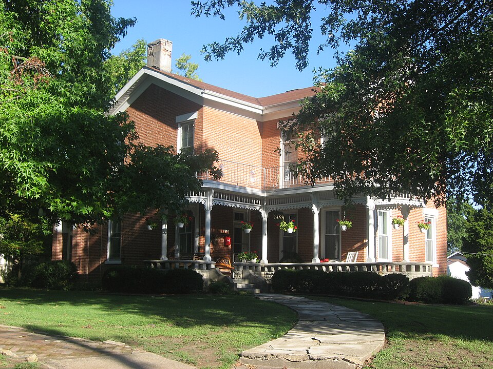
Photograph of Sparta Historic District
Photograph by Nyttend, Public domain. Via Wikimedia Commons.

Sparta Historic District

Listed on the National Register of Historic Places in 1982.

From the record

“The Sparta Historic District is a residential historic district in Sparta, Illinois. The district consists of fourteen homes in a neighborhood of southern Sparta known as Bricktown.”

Wikipedia article Sparta Historic District (Sparta, Illinois), CC BY-SA 4.0.

One of 12 National Register listings published here for Randolph County · listed in 1982 · category: District.

Sources: the Wikipedia article · the case file at the National Archives · the National Register database, National Park Service · the Wikipedia article
The listing

  • Address. S. St. Louis, W. 3rd and S. James Sts., Sparta, 62286
  • When was it listed? June 1982
  • Category. district
  • Precinct. Sparta precinct
  • National Register reference number. 82002595 - the number the National Park Service assigned this property when it was listed, and the key its nomination file is catalogued under at the National Archives.

Mines and quarries near this property

1 within 5 miles

Regional context, not property-specific evidence. The federal mineral resources record lists 1 working within 5 miles of Sparta Historic District: 1 past producer. None of them still produces. What was taken out: Stone, Crushed/Broken. Distance is straight-line from the map coordinates, so a quarry counted here may appear on a neighbouring settlement's page as well.

Where SiteCommodity StatusRecorded
Randolph County Highway DepartmentStone, Crushed/BrokenPast Producer

Every working recorded in Randolph County

Storms near this property

48 since 1993

Regional context, not property-specific evidence. The National Weather Service names Sparta, the town this property stands in, in 48 storm reports between 1993 and 2026: 27 hail, 19 thunderstorm wind, 2 tornado. No death or injury is recorded in these reports. Each account below is quoted exactly as the forecast office filed it, from the NOAA Storm Events Database, and each date opens the federal record of that event.

WhenEvent Place namedHarm What the report says
April 1994Thunderstorm WindSparta$50,000County officials reported a garage blown down along Highway 154 in Baldwin. A mobile home was heavily damaged in Sparta and several mobile home roofs were damaged in Coulterville. The county sheriff also reported trees and power lines down through out the county.
February 1999Thunderstorm WindSparta$10,000no account filed
April 1993Thunderstorm WindSparta$5,000A radio station reported downed power lines with wind gusts to 60 mph.
March 1996Thunderstorm WindSparta$5,000no account filed
April 1994Thunderstorm WindSparta$500The county sheriff reported numerous trees down between Sparta and Tilden along Highway 4.
March 2026Thunderstorm WindSparta-Thunderstorm winds downed a tree limb which damaged a mobile home. They also broke 2 power poles near the intersection of Route 154 and Plum Creek Road.
May 2018Thunderstorm WindSparta-Thunderstorm winds blew down several trees around town. One tree fell onto a house causing moderate damage.
May 2017Thunderstorm WindSparta-Thunderstorm winds blew down two trees on north side of town. One of the trees fell onto a house causing moderate roof damage and the other one fell onto power lines.
April 2011Thunderstorm WindSparta-Thunderstorm winds blew down numerous large tree limbs.
June 2011Thunderstorm WindSparta-Thunderstorm winds blew down numerous large tree limbs.
May 2008HailSparta-Storm spotters reported hail up to one inch fell on and off for about 30 minutes.
June 2004Thunderstorm WindSparta-An early morning thunderstorm caused scattered wind damage in Sparta. Large tree limbs and a few power lines were down. At least 1000 people lost power for about 4 hours.
June 2004Thunderstorm WindSparta-Storm spotters reported large tree limbs and power lines down.
November 2004Tornado (F0)Sparta-A small tornado uprooted and snapped off large trees at the Sparta Country Club.
November 2004Thunderstorm WindSparta-Thunderstorm wind gusts caused minor damage at a mobile home part on the south side of Sparta. A couple of trees were downed with one partially falling on a mobile home.
November 2004Tornado (F0)Sparta-A small tornado caused damage in downtown Sparta. Half of the roof of a church was blown off, a chimney was damaged, roof shingles blown off a couple of buildings, and some windows broken.
November 2004Thunderstorm WindSparta-Thunderstorm winds downed some trees, a sign, and damaged the roof of a motel along Highway 154.
May 2003HailSparta-The public reported nickel size hail in Sparta.
May 2003HailSparta-Fire Department personnel from Coulterville reported golfball size hail.
April 2002HailSparta-Storm spotters reported 3/4 inch hail west of Sparta.
April 2002HailSparta-Storm spotters reported 3/4 inch hail.
June 2001HailSparta-Storm spotters reported nickel size hail in Sparta.
May 1998HailSparta-Spotters reported 3/4 inch hail south of Sparta.
March 2008HailSparta-no account filed
April 2007HailSparta-no account filed
March 2006HailSparta-no account filed
April 2006Thunderstorm WindSparta-no account filed
April 2006HailSparta-no account filed
May 2006HailSparta-no account filed
September 2003HailSparta-no account filed
April 2003HailSparta-no account filed
May 2003HailSparta-no account filed
April 2002HailSparta-no account filed
August 2002HailSparta-no account filed
February 1999HailSparta-no account filed
June 1998Thunderstorm WindSparta-no account filed
June 1998HailSparta-no account filed
March 1997HailSparta-no account filed
April 1997HailSparta-no account filed
June 1996HailSparta-no account filed
July 1996Thunderstorm WindSparta-no account filed
March 1996HailSparta-no account filed

Every storm recorded in Randolph County

Map coverage status

No historic map-sheet match is published for this property yet. That does not mean no map exists. This record needs a coordinate-quality review before it can be joined to a sheet boundary. Browse the county's mapped places while that work is pending.

Listed places nearby

1 within 8 miles

Other National Register properties close enough to walk or drive between, ordered by distance from this one. Both positions come from the same geocoding pass that matched these properties to their map sheets.

Photograph PropertyDistance Listed
Charter Oak Schoolhouse5.3 miles1978

Sources for this property

National Archives recordThe nomination case file for reference 82002595 in Record Group 79.
Wikipedia articleCommunity-written account of this property, licensed CC BY-SA.
Randolph CountyAll 12 listed properties in this county.

Provenance

  • Listing record. National Park Service National Register of Historic Places, listed-properties dataset, current to 2026-05-22.
  • Map join. Address geocoded through the United States Census geocoder, then tested against the published boundary of every sheet in the USGS Historical Topographic Map Collection.
  • How this page is made. Listing fields come from federal records; map-sheet coverage is a labelled coordinate-to-boundary calculation, not a source-field claim.
  • Mines and quarries. USGS Mineral Resources Data System (MRDS) https://mrdata.usgs.gov/mrds/ A work of the United States government, no copyright under 17 U.S.C. 105.
  • Storms. NOAA National Centers for Environmental Information, Storm Events Database https://www.ncei.noaa.gov/stormevents/ A work of the United States government, no copyright under 17 U.S.C. 105. Narratives are quoted verbatim from the National Weather Service report and are not edited or summarised.