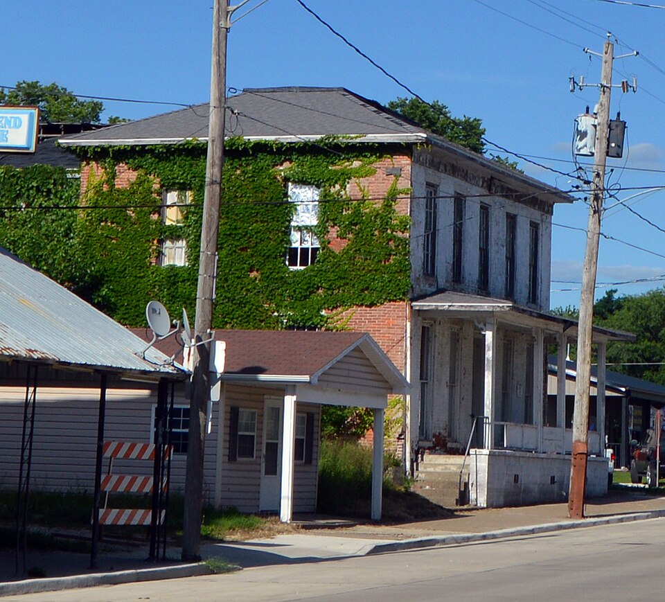
Built in 1849 (Italianate architecture). Listed on the National Register of Historic Places in 1983.
From the record
“The Commercial House is a historic hotel located at the intersection of 5th and Main Streets in Keithsburg, Illinois. Patterson built the hotel to be his own house in 1849; however, he sold it the next year to Samuel Phelps and moved to California, where he died.”
Wikipedia article Commercial House (Keithsburg, Illinois), CC BY-SA 4.0.
One of 12 National Register listings published here for Mercer County · listed in 1983 · category: Building · built in 1849, Italianate architecture.
National Register reference number.83000332- the number the National Park Service assigned this property when it was listed, and the key its nomination file is catalogued under at the National Archives.
The second settler of the county was John Vanatta, who located at Keithsburg in May, 1827. He opened a supply yard to furnish wood for the steamboats. A year or two afterwards his brother Benjamin joined him. He had preempted a claim on the southeast quarter of section 22 in 1833. John Bates settled on section 34 and a few years later Isom Lakey located on the same farm. About the spring of 1835 Samuel Vanatta, a brother of John, arrived, but in the fall of the same year all the Vanattas sold out to Robert Keith, a Scotchman, and removed to Muscatine, which was then called Bloomington. In the spring of 1836 Abner Martin built a house on section 13, but sold out the same vear to John McH. Wilson. In the same year William and Paul Sheriff settled on section 24. The next year William Sheriff built a sawmill on Pope Creek on section 23. He built a large dam and at first the mill seemed destined to become very useful, but it was located on quick sand, which undermined the structure and the mill was abandoned and finally rotted down. A. B. Sheriff arrived about 1836 and Matthew Sheriff a year or two later. T. B. Cabeen came about this date. Daniel Justice located on section 1 in 1836; John W. Nevius arrived the next year. William Wilson, the father of John McH. Wilson, arrived in 1836 also and settled on section 13. Bennett Hurst located a claim on section 2. Joel A. Hall, a millwright, arrived in 1838 and established a farm on section 13. In 1837 Benjamin F. Gruwell built a home on section 1. Later he kept a hotel in Keithsburg. Joseph J. Wordin arrived in 1837. Rev. James Ross reached the township about 1841. James Garner arrived about 1842 and started a small store at Keithsburg. He sold whisky and merchandise and was one of the first business men of the village. Robert Keith was the founder of Keithsburg. The place at first was nothing but a woodyard for the steamboats and was known as such, apparently not having any other name. In the spring of 1835 it became known as Keith's Landing. In July, 1837, Hiram Hardie, deputy county surveyor, laid off the Town of Keithsburg on section 23. The original plat shows Main and Washington streets east and west and crossed by First, Second, Third, etc., streets. In all thirteen blocks were surveyed and the first sale of lots occurred in July. 1837. They brought from twenty to sixty dollars each, but the place could hardly yet be called a village. The landing made it what it was and not any stores or shops. Garner sold out in 1839 to David Bower and moved out on section 25. In 1847 he returned and opened a hotel, was justice of the peace and sheriff. Bower went to Rock Island. A Frenchman named Rochelle arrived early in the '40s, and with a small quantity of goods brought up on a steamboat, started a store. Omy Brothers succeeded to this store. In 1842 Zephaniah Wade arrived and located on section 14 and the following year Nicholas Edwards settled on section 5 at the mouth of Edwards River. The previous year William Willett and Josiah Brown built a sawmill on the river, but in 1843 Willett sold his interest to Brown. In 1837 a Mr. Gavitt established a claim about a mile below the landing at Keithsburg and immediately laid off a small tract, which he named Columbia City. It was located on a high plateau and was the site of an old Indian encampment where yet could be seen the fields used in growing corn and vegetables by the Indians. Numerous evidences of their presence were shown, among which were pits of ashes and a few wigwam poles or bark of houses. This plat was not recorded and Columbia City, amounted to nothing. The claim passed to Alexander Davis. In 1837 Bluff postoffice was established at the house of Frederick Frick in Abington Township, keithsburg mail came there until 1846. The village amounted to very little until about 1846. Another early settler in the township was Rousy Bower, who arrived about 1834. He occupied a small house on the river bank and was employed by the Vanattas in chopping wood for the steamboats. Jesse Mount arrived about 1835.
Keithsburg became the county seat in 1847 and thereafter was a pretentious and promising place. However, the settlement of the township was still in progress. A body of farmers in 1844 formed an organization and endeavored to build a warehouse in Keithsburg for the storing and handling of grain. In those years the farmers back on the river brought their grain to river points because it could there be shipped to the large markets. Robert Keith assisted in this warehouse movement and contributed several lots upon which to erect the building. William Willett succeeded in getting title to the property soon after the frame was up and Col. J. B. Patterson, of Oquawka, secured an interest therein about the time it was finished. Patterson soon after this opened a store in the Keith Building and with him was associated Booth Nettleton. They sold dry goods and groceries on Washington Street. Patterson really came to Keithsburg in 1845 lor permanent residence, although he still had a home in Oquawka. His location at Keithsburg was for business purposes. His firm immediately began to buy large quantities of produce, grain, etc., from the farmers, and in turn thev sold enormous quantities of store goods to the farmers back from the river for many miles. They had a large establishment here, including one frame house, one log house and three cabins. His trade in 1845 was 3,690 bushels of wheat, 512 barrels flour and 2,250 bushels corn. Patterson himself had other interests and left after a year or two and the management of the concern passed to Noble & Gayle, who built a one-story frame store on Main and Second streets and a large warehouse on Lot 10. In 1848 they erected a brick packing house and at that time McConaha & Rife established a combined saloon and grocery. In 1848 also Jonathan Juda established a store. He was a Jew and a successful merchant. In 1848 also Wilford J. Ungles established a store on Washington Street and built a large warehouse in 1855, at which time he had become very prosperous. Seth Redman built a brick business block about 1855. Before it was finished he sold to Dr. A. B. Campbell. In 1849 McConaha & Rife dissolved, the latter engaging in the grocery business, but later added dry goods. Still later he put up a brick building. In 1848 T. B. Cabeen built the brick block on Main and Second streets. It was a three-story structure, his family occupying the upper stories. Below Miss E. Smith kept a store. She had come from New Boston and was a successful business woman.
Regional context, not property-specific
evidence. The
federal wildfire occurrence database
lists 3 fires within 5 miles of Commercial House
between 2013 and 2016, burning under an acre in total. None started naturally. None was recorded as arson.
Distance is straight-line from the map coordinates, so a fire counted
here may appear on a neighbouring settlement's page as well.
Reported cause
Fires
Recreation and ceremony
3
The most recent of
them, most recent first, with the day each was reported and the service
that recorded it.
Regional context, not property-specific
evidence. The federal mineral resources record lists
1 working within 5 miles of Commercial House: 1 occurrence.
None of them still produces. What was taken out: Stone, Crushed/Broken. Distance is straight-line from the
map coordinates, so a quarry counted here may appear on a neighbouring
settlement's page as well.
Regional context, not property-specific
evidence. The National Weather Service names
Keithsburg, the town this property stands in, in 20 storm reports between 1997 and 2024: 7 flood, 4 thunderstorm wind, 4 hail, 2 flash flood.
No death or injury is recorded in these reports. Each account below is quoted exactly as the forecast office
filed it, from the NOAA Storm Events Database, and each date
opens the federal record of that event.
The Mississippi River at Keithsburg rose above its major flood stage of 17 feet around 2 PM on July 2nd and crested at 19.02 feet on July 11th. The river fell back below major flood stage around 5 PM on July 20th.
The Mississippi River at Keithsburg (KHBI2) rose above its major flood stage of 17 feet during the early morning of May 20th and continued into June. The river crested in June, with the stage rising to 22.6 feet at the end of May 31st.
The Mississippi River at the KHBI2 gage rose above major flood stage of 17.0 feet on the 13th, and crested at 17.12 feet at 1 AM CST on the 15th. It fell back below 17.0 feet on the 17th.
The Mississippi River at Keithsburg and New Boston began June above their respective major flood stages of 15.5 feet and 18.5 feet. The river at New Boston crested on June 2nd at 24.40 feet and fell below its major flood stage on June 14th around 7 AM. This is preliminarily the 4th highest crest on record. The river at Keithsburg fell back below major flood stage on June 15th around 10 PM. The river crested at 22.95 feet on June 2nd. This is preliminarily the 3rd highest crest on record.
Episodes of heavy rainfall of about 5 to 15 inches in a 10 day period in much of northeast Iowa and southwest Wisconsin caused the Mississippi River to rise above major flood stage at at Keithsburg. The extended duration between the forecast and actual lower end major river flooding allowed preparations to preclude major damage downstream. Keithsburg rose above major flood stage of 17.0 feet at 11 PM CST on 8 September. Then crested around 17.27 feet at 915 PM CST on September 10th and fell below 17.0 feet at approximately 300 AM CST on 12 September.
The river rose above flood stage at Keithsburg on October 3 at 745 am cst and fell below flood stage on October 13 at 340 pm cst. Minor flooding occurred with the crest reaching 15.39 feet on October 7 at 800 pm cst. Flood stage is 14 feet.
Heavy rain of near 3 inches brought Pope creek out of it's bank near Keithsburg, closing a few gravel roads. Back water from the flooded Mississippi river also contributed to the minor flooding along the creek.
Heavy rain of 2 to 3 inches fell in a short period of time, which produced widespread street flooding in Keithsburg. Several county roads were closed due to standing water.
No historic map-sheet match is published
for this property yet. That does not mean no map exists. This record needs
a coordinate-quality review before it can be joined to a sheet boundary.
Browse the county's mapped places while that work is
pending.
Listed places nearby
5 within 8 miles
Other National Register properties close
enough to walk or drive between, ordered by distance from this one. Both
positions come from the same geocoding pass that matched these properties
to their map sheets.
Listing record. National Park Service National Register of Historic Places, listed-properties dataset, current to 2026-05-22.
Map join. Address geocoded through the United States Census geocoder, then tested against the published boundary of every sheet in the USGS Historical Topographic Map Collection.
How this page is made. Listing fields come from federal records; map-sheet coverage is a labelled coordinate-to-boundary calculation, not a source-field claim.
Wildfire. Short, Karen C. 2022. Spatial wildfire occurrence data for the United States, 1992-2020 [FPA_FOD_20221014]. 6th Edition. Fort Collins, CO: Forest Service Research Data Archive. https://doi.org/10.2737/RDS-2013-0009.6 Collected with United States Government funding and usable without additional permissions or fees.
Mines and quarries. USGS Mineral Resources Data System (MRDS) https://mrdata.usgs.gov/mrds/ A work of the United States government, no copyright under 17 U.S.C. 105.
Storms. NOAA National Centers for Environmental Information, Storm Events Database https://www.ncei.noaa.gov/stormevents/ A work of the United States government, no copyright under 17 U.S.C. 105. Narratives are quoted verbatim from the National Weather Service report and are not edited or summarised.
 Block