
BlockBefore
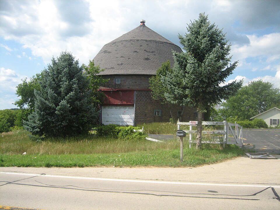
Photograph of Robert Weber Round Barn
Photograph by IvoShandor, CC BY 2.5. Via Wikimedia Commons.

Robert Weber Round Barn

Listed on the National Register of Historic Places in 1984.

From the record

“The Robert Weber Round Barn is a round barn located east of Durand, Illinois, United States along Illinois Route 75 in Harrison Township. The Weber barn was constructed in 1917 and features a roof designed and built by the Haas Brothers, who worked on other area round barns.”

Wikipedia article Robert Weber Round Barn, CC BY-SA 4.0.

One of 43 National Register listings published here for Winnebago County · listed in 1984 · category: Building.

Sources: the Wikipedia article · the case file at the National Archives · the National Register database, National Park Service

The listing

  • What is counted as historic. The nomination lists 1 building as contributing to the listing.
  • Listed as. Weber, Robert, Round Barn - the National Register files a house under its owner's surname.
  • Address. E of Durand, Durand, 61024
  • When was it listed? February 1984
  • Category. building
  • Also known as. Round Barns in Illinois TR
  • Township. Harrison township
  • National Register reference number. 84001172 - the number the National Park Service assigned this property when it was listed, and the key its nomination file is catalogued under at the National Archives.

The ground it stands on

4,958 words

The chapter on Harrison Township in The History of Winnebago County, Illinois : Its Past and Present, Containing ... a Biographical Directory of Its Citizens, War Record of Its Volunteers in the Late Rebellion, General and Local Statistics ... History of the Northwest, History of Illinois ... Etc, published 1877 names Durand. This is what it says, exactly as the scans read.

BODIXE WIL.1.IAM, Farmer; Sec. 18 ; P. O. Durand ; born in Canada in 1820 ; came to this Co. in 1840; owns 160 acres land ; married Harriet S. Babcock in 1843 ; she was born in N. Y. in 1827 ; had two children: Harriet L. and George W.F.; the latter was a member of the 55th I. V. I. ; died in hospital, and is buried at Nashville, Tenn. ; Mrs. B. died in 1846 ; married second time to Francis E. Albright, of O., born in 1831; have eight children living: Martha Z., Jethro J., Charles S., Esther L., Isaac J., Laura E., Arthusa and Anna Louisa; lost three: Joseph C, Dorcus 0. and Jacob ; Mr. B. was ordained a minister in 1852 (Free Will Baptist) ; preached chiefly to the Otter Creek congregation in Leona; his health failed him and he gave up preaching.

Passage source: The History of Winnebago County, Illinois : Its Past and Present, Containing ... a Biographical Directory of Its Citizens, War Record of Its Volunteers in the Late Rebellion, General and Local Statistics ... History of the Northwest, History of Illinois ... Etc, published 1877.

PATTERSON L.E\VIS, Farmer; Sec. 20; P. O. Durand; born in Lower Canada, Feb. 16, 1818; married Emily Blackburn,, in May, 1839; she was born in Ohio, March 5, 1821 ; came to this Co. in 1839; owns 120 acres land; they have two children living: Frederick W., born April 5, 1846, and Marion, Oct. 21, 1855; lost two sons in the army ; John A. was wounded at the battle of Shiloh, and taken prisoner, where it is supposed he died, as he was not heard of afterward ; George C. was killed at the battle of Franklin, Tenn. ; was in Co. B, 72d I. V.*I. ; had served 2 years and 4 months ; Mr. P. has been Justice of the Peace 15 years, served three terms as Collector, four as Assessor, and has been School Director for 20 years ; the only survivng son, Fredric, married

Passage source: The History of Winnebago County, Illinois : Its Past and Present, Containing ... a Biographical Directory of Its Citizens, War Record of Its Volunteers in the Late Rebellion, General and Local Statistics ... History of the Northwest, History of Illinois ... Etc, published 1877.

Machine-read from a century-old scan, so expect the errors a machine makes: misspelled names, dropped words, stray characters.

Read the whole chapter on Harrison Township - 4,958 words on its settlement, mills, schools and churches.

Fires near this property

2 since 2018

Regional context, not property-specific evidence. The federal wildfire occurrence database lists 2 fires within 5 miles of Robert Weber Round Barn between 2018 and 2020, burning about 1 acre in total. None started naturally. None was recorded as arson. Distance is straight-line from the map coordinates, so a fire counted here may appear on a neighbouring settlement's page as well.

Reported cause Fires
Fireworks1
Missing data/not specified/undetermined1

The most recent of them, most recent first, with the day each was reported and the service that recorded it.

DateCause SizeReported by Name on the report
4 May 2020Fireworksunder an acreIllinois Division of Forestry Resources20-0000217
26 March 2018Missing data/not specified/undeterminedunder an acreIllinois Division of Forestry Resources18-0274

Every fire recorded in Winnebago County

Mines and quarries near this property

7 within 5 miles

Regional context, not property-specific evidence. The federal mineral resources record lists 7 workings within 5 miles of Robert Weber Round Barn: 7 past producers. None of them still produces. What was taken out: Stone, Crushed/Broken. Distance is straight-line from the map coordinates, so a quarry counted here may appear on a neighbouring settlement's page as well.

Where SiteCommodity StatusRecorded
Austin QuarryStone, Crushed/BrokenPast Producer
Faulkner QuarryStone, Crushed/BrokenPast Producer
Richardson QuarryStone, Crushed/BrokenPast Producer
Trask Bridge QuarryStone, Crushed/BrokenPast Producer
Unnamed Limestone QuarryStone, Crushed/BrokenPast Producer

Every working recorded in Winnebago County

Storms near this property

23 since 1998

Regional context, not property-specific evidence. The National Weather Service names Durand, the town this property stands in, in 23 storm reports between 1998 and 2026: 13 thunderstorm wind, 8 hail, 1 tornado, 1 flash flood. No death or injury is recorded in these reports. Each account below is quoted exactly as the forecast office filed it, from the NOAA Storm Events Database, and each date opens the federal record of that event.

WhenEvent Place namedHarm What the report says
April 2026Thunderstorm WindDurand-A photo was shared of a tree uprooted in Durand.
April 2026HailDurand-A few hail reports came from south of Durand ranging in size from 1.25 to 2.25 inches in diameter.
April 2026Thunderstorm WindDurand-Softwood trees were snapped near the intersection of Task Bridge Rd and Best Rd north of Pecatonica.
April 2026Thunderstorm WindDurand-Several photos were received of broken windows and damaged siding from in and around Durand due to a combination of severe winds and hail.
July 2024Thunderstorm WindDurand-Multiple reports of tree damage were received southeast of Durand.
April 2024Thunderstorm WindDurand-Power lines were downed in Durand.
May 2022HailDurand-Nickel to quarter size hail was reported near Center and Main Streets.
July 2022Thunderstorm WindDurand-Several large tree limbs were blown down and a large tree was snapped along Laube Road, between Center and Rowley Roads. Some of the large tree limbs fell onto a house, damaging a deck railing.
July 2018Thunderstorm WindDurand-A three foot diameter tree was uprooted on Route 75, one mile east of Wheeler Road.
June 2017Thunderstorm WindDurand-Five trees and numerous tree limbs were blown down.
July 2016Thunderstorm WindDurand-Two trees down across road with one utility pole pulled down by trees. Time estimated.
June 2010HailDurand-Nickel size hail was reported near Lake Summerset.
July 2007Thunderstorm WindDurand-Two trees blown down.
August 2007Thunderstorm WindDurand-A tree and limbs were blown down near Lake Summerset and the Winnebago Stephenson County line.
May 2005HailDurand-Nickel size hail was reported near Lake Summerset.
June 1998Tornado (F0)Durand-A small tornado touched down briefly near Durand. There was no damage.
April 2026HailDurand-no account filed
May 2017HailDurand-no account filed
May 2011HailDurand-no account filed
October 2006HailDurand-no account filed
May 2004Flash FloodDurand-no account filed
August 2002Thunderstorm WindDurand-no account filed
September 2000Thunderstorm WindDurand-no account filed

Every storm recorded in Winnebago County

Map coverage status

No historic map-sheet match is published for this property yet. That does not mean no map exists. This record needs a coordinate-quality review before it can be joined to a sheet boundary. Browse the county's mapped places while that work is pending.

Sources for this property

National Archives recordThe nomination case file for reference 84001172 in Record Group 79.
Wikipedia articleCommunity-written account of this property, licensed CC BY-SA.
Winnebago CountyAll 43 listed properties in this county.

Provenance

  • Listing record. National Park Service National Register of Historic Places, listed-properties dataset, current to 2026-05-22.
  • Map join. Address geocoded through the United States Census geocoder, then tested against the published boundary of every sheet in the USGS Historical Topographic Map Collection.
  • How this page is made. Listing fields come from federal records; map-sheet coverage is a labelled coordinate-to-boundary calculation, not a source-field claim.
  • Wildfire. Short, Karen C. 2022. Spatial wildfire occurrence data for the United States, 1992-2020 [FPA_FOD_20221014]. 6th Edition. Fort Collins, CO: Forest Service Research Data Archive. https://doi.org/10.2737/RDS-2013-0009.6 Collected with United States Government funding and usable without additional permissions or fees.
  • Mines and quarries. USGS Mineral Resources Data System (MRDS) https://mrdata.usgs.gov/mrds/ A work of the United States government, no copyright under 17 U.S.C. 105.
  • Storms. NOAA National Centers for Environmental Information, Storm Events Database https://www.ncei.noaa.gov/stormevents/ A work of the United States government, no copyright under 17 U.S.C. 105. Narratives are quoted verbatim from the National Weather Service report and are not edited or summarised.