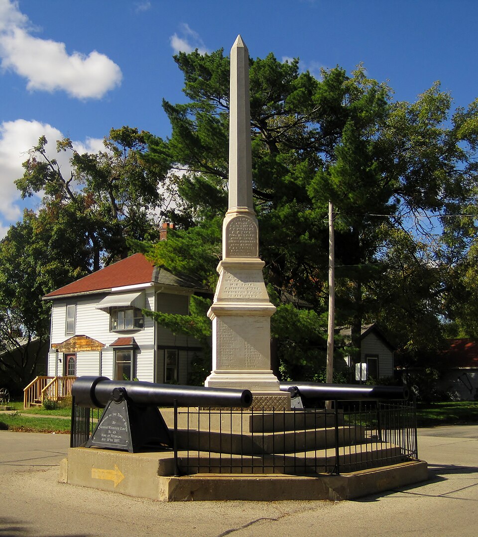
Listed on the National Register of Historic Places in 1985.
From the record
“The Soldier's Monument in Byron, Illinois, is a listing on the National Register of Historic Places. Located in Ogle County, Illinois, the monument is the city of Byron's only National Register listing.”
Wikipedia article Soldier's Monument (Byron, Illinois), CC BY-SA 4.0.
One of 29 National Register listings published here for Ogle County · listed in 1985 · category: Object.
National Register reference number.85000268- the number the National Park Service assigned this property when it was listed, and the key its nomination file is catalogued under at the National Archives.
About the first of July, 1835, Jared W. Sanford came up Rock River from Dixon, on horseback, en roufe (or Rockford - then called "Midway." Noting the excellent water privilege a mile west of the present site of Byron, on Leaf River, he laid claim to it by planting there a claim-stake, and proceeded on up the river. His brother, Joseph, and Perry Norton were then working on Kent's mill at Midway, and when told of the beautiful country south, they were induced to go down and examine it.
Mr. Norton still resides one and a half miles north of Byron, and is the oldest living resident. An account of his trip to the " far West," as it was then called, may be of some interest, showing, as it does, the vast changes time has made. From ocean to ocean is now but a pleasant ride of seven days, in palace coaches. Mr. Norton was from April 26 to May 26, 1835, in traveling from New York to Galena. The route was : to Buffalo by canal, to Detroit bv steamboat, across Michigan to Chicago by stage - all passage seats to Chicago were taken fifteen days in advance, such was the multitude seeking Western homes - from Chicago to Ottawa by stage. Ottawa had one tavern, one store, a few dwellings on the south side of the Illinois River, one on the north, and one between the Fox and Illinois Rivers. He went to Paw Paw Grove by private conveyance, and thence to Dixon on foot. Dixon consisted of a tavern, kept by a man named Black, in the old fort of the Black Hawk War, and five or six dwellings. He then went by stage to Galena, where he hired out to a Mr. Brush, agent for Germanicus Kent, of Midway. He arrived there on the eighth day of June. Rockford then consisted of two families and eight or ten young men ; Mr. Kent on the west, and Mr. Haight on the east side of the river. Mr. Kent had begun improvements there in the Fall of 1834; had commenced building a dam across the creek, near the Holland (now the Tinker) place. During the season of Mr. Norton's arrival immigration became more general ; among the settlers were Montague Dunbar, Fox Wood and family, Boswell and family,Thatcher Blake, still a resident of Rockford, and Joseph Sanford, who came in the Fall or Winter of 1834.
Regional context, not property-specific
evidence. The
federal wildfire occurrence database
lists 1 fire within 5 miles of Soldier's Monument
in 2019, burning about 2 acres in total. None started naturally. None was recorded as arson.
Distance is straight-line from the map coordinates, so a fire counted
here may appear on a neighbouring settlement's page as well.
Reported cause
Fires
Missing data/not specified/undetermined
1
The most recent of
them, most recent first, with the day each was reported and the service
that recorded it.
Regional context, not property-specific
evidence. The federal mineral resources record lists
12 workings within 5 miles of Soldier's Monument: 10 past producers, 2 producers.
2 still produce. What was taken out: Stone, Crushed/Broken, Sand and Gravel, Construction. Distance is straight-line from the
map coordinates, so a quarry counted here may appear on a neighbouring
settlement's page as well.
Regional context, not property-specific
evidence. The National Weather Service names
Byron, the town this property stands in, in 31 storm reports between 1996 and 2026: 18 thunderstorm wind, 6 hail, 3 flood, 1 lightning.
The reports record 1 injury. Each account below is quoted exactly as the forecast office
filed it, from the NOAA Storm Events Database, and each date
opens the federal record of that event.
A local partner shared photos and reports of damage to soffits and fencing in a neighborhood along Southfield Lane in Byron. A garage door was reportedly blown in, as well.
A tornado with estimated peak winds of 80 mph touched down in a corn field just southeast of the intersection of Lightsville Road and Conger Road, as seen in high resolution satellite imagery. The tornado moved southeast and then turned to the east as it moved through Bryon where it produced tree damage. Roofing material was blown off of a car wash near the corner of Route 2 and Colfax Street. The tornado crossed the Rock River and ended just east of Hales Corner Road.
Standing water was reported at the Route 2 railroad underpass around 4:30 am CST which worsened to a depth of four feet an hour later. A private weather station measured 5.29 inches of rain 3 miles east northeast of Bryon.
Major river flooding occurred along portions of the Rock River near Bryon. The river crested at 16.64 feet on March 16th. Moderate flood stage is 14 feet and major flood stage is 16 feet. This crest of 16.64 feet was the third highest on record at Bryon.
Water one foot deep was reported underneath the railroad viaduct on Route 2 where a vehicle was stalled. Water over one foot deep was reported on 2nd Avenue.
Moderate flooding occurred along portions of the Rock River near Bryon. The river crested at 15.39 feet on October 8th. Moderate flood stage is 14 feet and major flood stage is 16 feet. This crest of 15.39 feet was the 6th highest on record at Byron.
No historic map-sheet match is published
for this property yet. That does not mean no map exists. This record needs
a coordinate-quality review before it can be joined to a sheet boundary.
Browse the county's mapped places while that work is
pending.
Listed places nearby
2 within 8 miles
Other National Register properties close
enough to walk or drive between, ordered by distance from this one. Both
positions come from the same geocoding pass that matched these properties
to their map sheets.
Listing record. National Park Service National Register of Historic Places, listed-properties dataset, current to 2026-05-22.
Map join. Address geocoded through the United States Census geocoder, then tested against the published boundary of every sheet in the USGS Historical Topographic Map Collection.
How this page is made. Listing fields come from federal records; map-sheet coverage is a labelled coordinate-to-boundary calculation, not a source-field claim.
Wildfire. Short, Karen C. 2022. Spatial wildfire occurrence data for the United States, 1992-2020 [FPA_FOD_20221014]. 6th Edition. Fort Collins, CO: Forest Service Research Data Archive. https://doi.org/10.2737/RDS-2013-0009.6 Collected with United States Government funding and usable without additional permissions or fees.
Mines and quarries. USGS Mineral Resources Data System (MRDS) https://mrdata.usgs.gov/mrds/ A work of the United States government, no copyright under 17 U.S.C. 105.
Storms. NOAA National Centers for Environmental Information, Storm Events Database https://www.ncei.noaa.gov/stormevents/ A work of the United States government, no copyright under 17 U.S.C. 105. Narratives are quoted verbatim from the National Weather Service report and are not edited or summarised.
 Block