BlockBefore
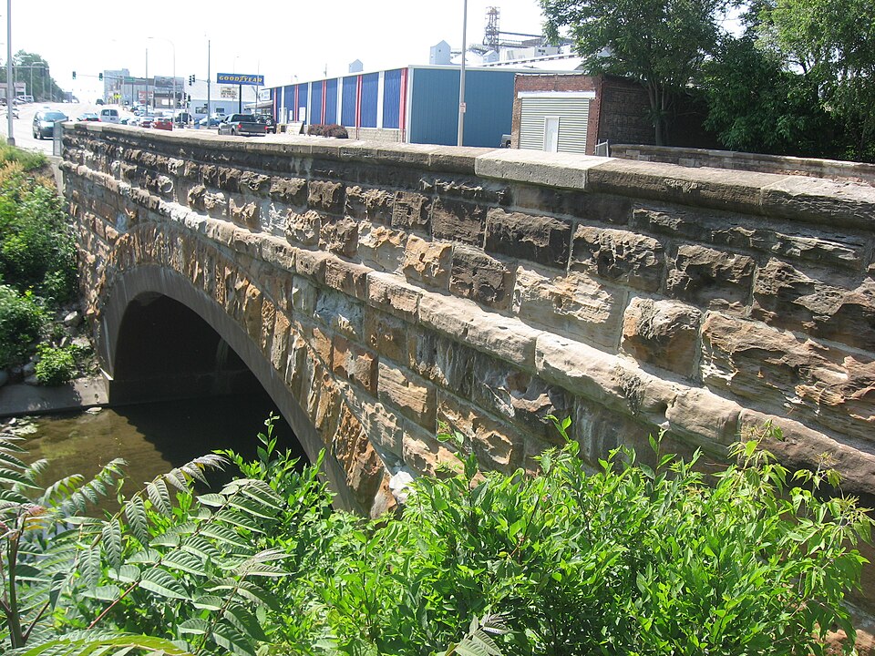
Photograph of Stone Arch Bridge
Photograph by Nyttend, Public domain. Via Wikimedia Commons.

Stone Arch Bridge

Listed on the National Register of Historic Places in 1986.

From the record

One of 13 National Register listings published here for Vermilion County · listed in 1986 · category: Structure.

Sources: the case file at the National Archives · the National Register database, National Park Service · the Wikipedia article

The listing

  • What is counted as historic. The nomination lists 1 structure as contributing to the listing.
  • Address. 760--800 E. Main St., Danville, 61832
  • When was it listed? May 1986
  • Category. structure
  • Township. Danville township
  • National Register reference number. 86001087 - the number the National Park Service assigned this property when it was listed, and the key its nomination file is catalogued under at the National Archives.

The ground it stands on

73,461 words

The chapter on Danville Township in History of Vermilion County, Together with Historic Notes on the Northwest, Gleaned from Early Authors, Old Maps and Manuscripts, Private and Official Correspondence, and Other Authentic, Though, for the Most Part, Out-of-the-way Sources, published 1879 names Danville. This is what it says, exactly as the scans read.

The Illinois Printing Company was organized under the laws of the state in 1874, - it being a continuation, so far as its business is concerned, of the printing firm of G. W. ETynn A: Co., and the "'Danville News." Capital, 850.000. Its business is the carrying on of the printing business, the publication of the ''Danville News," a daily morning paper with a weekly edition ; the printing and binding of county blanks and records, railroad printing, fair and show printing in all its forms, and everything pertaining to the '"art preservative.' G. W. Flynn is president and manager ; W. K. Jewell is vice-president and editor, and J. H. Woo dm an see, secretary and treasurer. The company has a fine building built expressly for the business, and is provided with all latest improved machinery for so large a business. They have the Taylor, Hoe, Gordon and Colter presses, employ about forty hands, and propose to conduct stereotyping as a branch of their business.

Passage source: History of Vermilion County, Together with Historic Notes on the Northwest, Gleaned from Early Authors, Old Maps and Manuscripts, Private and Official Correspondence, and Other Authentic, Though, for the Most Part, Out-of-the-way Sources, published 1879.

The "Danville Commercial" Company was organized under the state law by J. C. Short & Co., for the purpose of publishing the "Danville Commercial, " and earring on a general printing business. Several changes have been made in its officers, but its business has continued to be the same. It publishes the " Daily Commercial " and a weekly edition, carries on a regular printing business in all its branches, has a full supply of all that goes to make up a first-class printing house. In 1874, J. C. Short & Co. having disposed of what stock they still held in the company, a reorganization took place, and A. Harper was elected president ; Park T. Martin, secretary and editor, and later, Mr. A. J. Adams became business manager. Under the management of these gentlemen, who have had large experience in the printing and publishing business, a thriving business is being carried on.

Passage source: History of Vermilion County, Together with Historic Notes on the Northwest, Gleaned from Early Authors, Old Maps and Manuscripts, Private and Official Correspondence, and Other Authentic, Though, for the Most Part, Out-of-the-way Sources, published 1879.

Machine-read from a century-old scan, so expect the errors a machine makes: misspelled names, dropped words, stray characters.

Read the whole chapter on Danville Township - 73,461 words on its settlement, mills, schools and churches.

Fires near this property

5 since 2004

Regional context, not property-specific evidence. The federal wildfire occurrence database lists 5 fires within 5 miles of Stone Arch Bridge between 2004 and 2014, burning about 16 acres in total. None started naturally. None was recorded as arson. Distance is straight-line from the map coordinates, so a fire counted here may appear on a neighbouring settlement's page as well.

Reported cause Fires
Debris and open burning2
Smoking1
Missing data/not specified/undetermined1
Equipment and vehicle use1

The most recent of them, most recent first, with the day each was reported and the service that recorded it.

DateCause SizeReported by Name on the report
23 September 2011Missing data/not specified/undetermined10 acresIllinois Division of Forestry ResourcesDANVILLE
23 March 2004Smokingunder an acreIllinois State Fire Marshal's Officenot named
17 March 2014Debris and open burning3.0 acresIllinois Division of Forestry ResourcesHOLLOWRD92
29 December 2013Debris and open burningunder an acreIllinois Division of Forestry ResourcesJORDAN1
8 October 2010Equipment and vehicle use1.5 acresIllinois Division of Forestry ResourcesHUGHES

Every fire recorded in Vermilion County

Mines and quarries near this property

5 within 5 miles

Regional context, not property-specific evidence. The federal mineral resources record lists 5 workings within 5 miles of Stone Arch Bridge: 3 past producers, 1 occurrence, 1 producer. 1 still produces. What was taken out: Sand and Gravel, Construction, Clay, Fire Clay (Refractory). Distance is straight-line from the map coordinates, so a quarry counted here may appear on a neighbouring settlement's page as well.

Where SiteCommodity StatusRecorded
Danville PitClayPast Producer
Western Brick Co. Shale ExposureFire Clay (Refractory)Occurrence
Sand Valley Sand & GravelSand and Gravel, ConstructionProducer
Thomas PitSand and Gravel, ConstructionPast Producer
Tucker PitSand and Gravel, ConstructionPast Producer

Every working recorded in Vermilion County

Storms near this property

60 of 95 shown

Regional context, not property-specific evidence. The National Weather Service names Danville, the town this property stands in, in 95 storm reports between 1994 and 2024: 67 thunderstorm wind, 24 hail, 3 flash flood, 1 lightning. No death or injury is recorded in these reports. Each account below is quoted exactly as the forecast office filed it, from the NOAA Storm Events Database, and each date opens the federal record of that event.

WhenEvent Place namedHarm What the report says
May 1998Thunderstorm WindDanville$350,000A severe thunderstorm moved south across Vermilion County. It caused considerable damage to the roof of a canning factory in Danville, as well as, destroying a nearby gas station's sign and causing minor damage to a hotel roof. As the storm moved into Georgetown, it blew down several large tree limbs and power lines. No injuries were reported. Damage to the canning factory was estimated around $350,000.
August 2020Thunderstorm WindDanville$100,000Numerous trees and power lines were blown down throughout Danville. Several streets were blocked.
March 2017Thunderstorm WindDanville$80,000Numerous trees and power lines were blown down in Danville.
June 2015Thunderstorm WindDanville$80,000Numerous trees were blown down in Danville causing power outages across the city.
April 2020Thunderstorm WindDanville$70,000Roof damage to buildings on Bensyl and Emerson and the 100 block of North Walnut.
November 2016Thunderstorm WindDanville$70,000Numerous power lines were blown down in Danville.
November 2013Thunderstorm WindDanville$60,000A roof was blown off a house.
June 2015Thunderstorm WindDanville$50,000A 30x50 farm building was destroyed by strong thunderstorm winds.
August 2013Thunderstorm WindDanville$50,000Several trees were blown down in Danville. Approximately 200 people lost power as 50 to 60 mph winds arrived along a gust front.
July 2017Thunderstorm WindDanville$40,000Several trees were snapped or uprooted across Danville.
May 2013Thunderstorm WindDanville$40,000Numerous power lines were blown down around Danville.
May 2011Thunderstorm WindDanville$40,000Several trees and powerlines were blown down near Danville.
May 2011Thunderstorm WindDanville$40,000Numerous powerlines were blown down on the east side of Danville.
June 2016Thunderstorm WindDanville$35,000Several trees were blown down in Danville, including one that fell on a parked car.
June 2011Thunderstorm WindDanville$35,000Several trees were blown down in Danville. In addition, a power pole was knocked down at the intersection of 3rd St. and Highland Blvd.
June 2009Thunderstorm WindDanville$35,000Numerous trees and power lines were blown down. A house was damaged by a falling tree.
July 2013Thunderstorm WindDanville$30,000Numerous trees and tree branches were blown down across Danville.
August 2010Thunderstorm WindDanville$30,000Numerous trees and power lines were blown down on the north side of Danville.
June 2008Thunderstorm WindDanville$30,000Numerous trees down on the south and east side of Danville.
June 2010Thunderstorm WindDanville$25,000Numerous power lines were blown down.
September 2015Thunderstorm WindDanville$20,000Numerous large tree branches were blown down across Danville.
June 2011Thunderstorm WindDanville$20,000Numerous trees were blown down along Grape Creek Road south of Danville.
August 2008Thunderstorm WindDanville$20,000Numerous trees were blown down in Danville.
March 2017Thunderstorm WindDanville$15,000Numerous small trees and tree limbs were blown down. Railroad crossing gates were blown off and broken as well.
June 2013Thunderstorm WindDanville$15,000A 2-foot diameter tree was blown down onto a car in Danville.
July 2008Thunderstorm WindDanville$15,000Power lines were blown down on the southeast side of Danville.
March 2017Thunderstorm WindDanville$14,000Two power poles were blown down.
June 2011Thunderstorm WindDanville$10,000Power lines were blown down on Gilbert Street in Danville.
June 2013Thunderstorm WindDanville$8,000A tree and power lines were blown down at Bowman and Seminary Streets in Danville.
May 2008Thunderstorm WindDanville$5,000A large tree was blown down onto power lines.
July 2012Thunderstorm WindDanville$3,000A large tree was blown down near the intersection of 1750E and 2000N.
May 2015Thunderstorm WindDanville$2,000A tree and a large tree limb were blown down.
July 2015Thunderstorm WindDanville$2,000A tree was blown down across the railroad tracks at 3rd Street in Danville.
March 2012LightningDanville$2,000Lightning struck a power pole, knocking down power lines across a road in Danville.
June 2010Thunderstorm WindDanville$2,000A large tree was blown down.
July 2008Thunderstorm WindDanville$2,000A tree was blown down 1 mile north of the Danville airport.
June 2014Thunderstorm WindDanville$1,500A large tree was blown down at Liberty Lane and Ferndale in Danville.
July 2014Thunderstorm WindDanville$1,000A large tree was blown down onto Franklin Street.
July 2024Thunderstorm WindDanville-A few trees were blown down across powerlines.
July 2024Thunderstorm WindDanville-An 8 to 10-inch diameter 20-foot long tree branch was blown down on Bowman Avenue.
July 2024Thunderstorm WindDanville-Numerous power lines and trees were blown down near Danville.
May 2023Thunderstorm WindDanville-A large tree was blown down.
June 2023Thunderstorm WindDanville-Several trees were blown down, including one that fell onto a house.
June 2023Thunderstorm WindDanville-A large tree was blown over onto power poles.
June 2023Thunderstorm WindDanville-The roof of a business was damaged on the south side of Danville.
June 2023Thunderstorm WindDanville-Memorial Bridge was blocked by downed trees.
July 2022Thunderstorm WindDanville-Power lines downed in Danville.
April 2020Thunderstorm WindDanville-A tree was blown down at Bowman and May Street.
May 2019Thunderstorm WindDanville-A few trees were blown down across Danville.
May 2019Thunderstorm WindDanville-Numerous trees, tree limbs, and power lines were blown down across Danville. At least two houses were damaged by falling trees.
June 2019Thunderstorm WindDanville-Tree limbs were blown down near Lake Vermilion.
June 2019Thunderstorm WindDanville-Several large limbs and power lines were blown down in the 700 block of South Street.
May 2019Thunderstorm WindDanville-A large tree was blown onto a garage.
August 2019Thunderstorm WindDanville-Several trees and tree branches were blown down in Danville.
August 2009Thunderstorm WindDanville-Numerous trees were blown down across Danville.
August 2005Thunderstorm WindDanville-Building under construction damaged by wind gusts and a nearby tree was uprooted.
June 2004Flash FloodDanville-Very heavy rain caused flooding in Danville as well as county roads including IL Route 119 east of IL Route 1.
June 2004Flash FloodDanville-Morin subdivision evacuated due to flooding.
June 2004Thunderstorm WindDanville-Several trees and power lines were blown down.
July 2004Thunderstorm WindDanville-Several power lines and trees were blown down.

Every storm recorded in Vermilion County

Map coverage status

No historic map-sheet match is published for this property yet. That does not mean no map exists. This record needs a coordinate-quality review before it can be joined to a sheet boundary. Browse the county's mapped places while that work is pending.

Listed places nearby

6 within 8 miles

Other National Register properties close enough to walk or drive between, ordered by distance from this one. Both positions come from the same geocoding pass that matched these properties to their map sheets.

Photograph PropertyDistance Listed
Adams Building0.7 miles2000
First National Bank Building0.7 miles2018
United States Post Office and Court House0.7 miles2016
Danville Public Library0.7 miles1978
Holland Apartments0.8 miles1988
Building at 210-212 West North Street0.8 miles2000

Sources for this property

National Archives recordThe nomination case file for reference 86001087 in Record Group 79.
Wikipedia articleCommunity-written account of this property, licensed CC BY-SA.
Vermilion CountyAll 13 listed properties in this county.

Provenance

  • Listing record. National Park Service National Register of Historic Places, listed-properties dataset, current to 2026-05-22.
  • Map join. Address geocoded through the United States Census geocoder, then tested against the published boundary of every sheet in the USGS Historical Topographic Map Collection.
  • How this page is made. Listing fields come from federal records; map-sheet coverage is a labelled coordinate-to-boundary calculation, not a source-field claim.
  • Wildfire. Short, Karen C. 2022. Spatial wildfire occurrence data for the United States, 1992-2020 [FPA_FOD_20221014]. 6th Edition. Fort Collins, CO: Forest Service Research Data Archive. https://doi.org/10.2737/RDS-2013-0009.6 Collected with United States Government funding and usable without additional permissions or fees.
  • Mines and quarries. USGS Mineral Resources Data System (MRDS) https://mrdata.usgs.gov/mrds/ A work of the United States government, no copyright under 17 U.S.C. 105.
  • Storms. NOAA National Centers for Environmental Information, Storm Events Database https://www.ncei.noaa.gov/stormevents/ A work of the United States government, no copyright under 17 U.S.C. 105. Narratives are quoted verbatim from the National Weather Service report and are not edited or summarised.