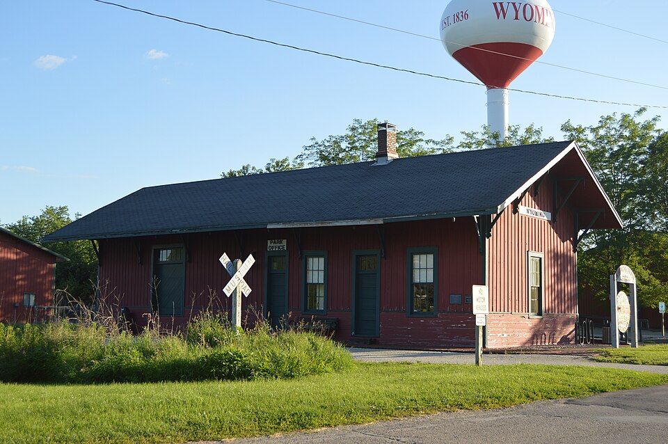
Listed on the National Register of Historic Places in 1987.
From the record
“Wyoming was a Chicago, Burlington and Quincy Railroad station in Wyoming, Illinois. Now the headquarters of the Rock Island Trail State Park, the building is listed on the National Register of Historic Places as the Chicago, Burlington & Quincy Railroad Depot.”
Wikipedia article Wyoming station (Illinois), CC BY-SA 4.0.
One of 2 National Register listings published here for Stark County · listed in 1987 · category: Building.
Architect. Chicago, Burlington and Quincy Railroad
National Register reference number.87000650- the number the National Park Service assigned this property when it was listed, and the key its nomination file is catalogued under at the National Archives.
I II IS division of the county was settled in 1829 by the Essex family, in whose honor the name was given to it in 1853, by Calvin Eastman, Henry Breese and T. F. Hurd, the commissioners under the act of 1851 for dividing the county into townships. Essex forms the center of the trio of Stark's southern divisions. It is a full congressional township ; but owing to the fact that the vagrant Spoon river and rambling Indian creek selected it as a special section for their wanderings, the area under cultivation is not of equal extent. The population in 1880, including part of Wyoming village, was 1,452, the village claiming 434. The villages of Duncan, Slackwater, and Stringtown form the leading settlements. Moulton on its northern border, and Massillon on its western border long since passed away, and their sites were plowed over by the modern husbandman. Princeville township, adjoining on the south, was settled by Daniel Prince, in 1822, but the family of Stephen French was the first there. Miss Esther Stoddard taught'the first school ; Theodore F. Hurd was the first male teacher. Rev. Robert Stewart, a Presbyterian, was the first preacher, while the first death was that of Isaac Essex's father-inlaw. Princeville village was platted for W. C. Stevens, in 1837, where the Presbyterian church of 1834 was built. Monica is a new village. About the time the first settlers came into this district of Spoon river, the Indians were residents. Subsequently they moved some miles westward and did not return until 1830, when they remained a few years. At this time the forest presented its huge trees without underbrush, with Indian trails stretching out in every direction.
The largest log ever cut in Stark county was that cut in Abner Kerns' timber, just west of Thomas Falkner's farm, in 1876. It is known as the " Centennial Walnut Log." It measured 13 feet long, 5A feet in diameter, and 17 feet in circumference. Payne, Thomas, David, James, Richard and Abner Kerns assisted in hauling it to the depot at Wyoming for shipment to Chicago.
Regional context, not property-specific
evidence. The federal mineral resources record lists
1 working within 5 miles of Chicago, Burlington & Quincy Railroad Depot: 1 past producer.
None of them still produces. What was taken out: Sand and Gravel, Construction. Distance is straight-line from the
map coordinates, so a quarry counted here may appear on a neighbouring
settlement's page as well.
Regional context, not property-specific
evidence. The National Weather Service names
Wyoming, the town this property stands in, in 22 storm reports between 1998 and 2025: 14 thunderstorm wind, 5 hail, 2 tornado, 1 flash flood.
No death or injury is recorded in these reports. Each account below is quoted exactly as the forecast office
filed it, from the NOAA Storm Events Database, and each date
opens the federal record of that event.
Widespread wind damage occurred from the north side of Wyoming northeastward to Bradford. Numerous trees, tree branches, and power lines were blown down along this path. In addition, minor damage to a few sheds and outbuildings was reported.
A tornado touched down in a field about 4.6 miles east-southeast of Wyoming in Stark County at 1:08 PM CDT. The tornado traveled northwestward for 1.3 miles, crossing County Road 1500 E, before dissipating 3.5 miles east of Wyoming at 1:11 PM CDT. No damage was reported.
A tornado touched down 6.5 miles east of Wyoming (Stark County). As it traveled east, it blew out 5 windows on a house and damaged the roof of a barn. Also, numerous trees were either uprooted or snapped off. The tornado then crossed from Stark County into Marshall County 7.3 miles east northeast of Wyoming. No injuries were reported.
Numerous large trees were blown down. Several fell down across Hwy 93 five miles west of Bradford. No injuries were reported and no damage estimate was available.
No historic map-sheet match is published
for this property yet. That does not mean no map exists. This record needs
a coordinate-quality review before it can be joined to a sheet boundary.
Browse the county's mapped places while that work is
pending.
Listed places nearby
1 within 8 miles
Other National Register properties close
enough to walk or drive between, ordered by distance from this one. Both
positions come from the same geocoding pass that matched these properties
to their map sheets.
Listing record. National Park Service National Register of Historic Places, listed-properties dataset, current to 2026-05-22.
Map join. Address geocoded through the United States Census geocoder, then tested against the published boundary of every sheet in the USGS Historical Topographic Map Collection.
How this page is made. Listing fields come from federal records; map-sheet coverage is a labelled coordinate-to-boundary calculation, not a source-field claim.
Mines and quarries. USGS Mineral Resources Data System (MRDS) https://mrdata.usgs.gov/mrds/ A work of the United States government, no copyright under 17 U.S.C. 105.
Storms. NOAA National Centers for Environmental Information, Storm Events Database https://www.ncei.noaa.gov/stormevents/ A work of the United States government, no copyright under 17 U.S.C. 105. Narratives are quoted verbatim from the National Weather Service report and are not edited or summarised.
 Block