 Block
From the record
2 National Register listings published here.
Sources: the county history on the Internet Archive · the National Register database, National Park Service
46 topographic sheets cover 16 settlements here, and 2 properties are on the National Register of Historic Places.
2 National Register listings published here.
Sources: the county history on the Internet Archive · the National Register database, National Park Service
Every property in this county listed on the National Register of Historic Places, with the year it was listed and the federal nomination document.
| Photograph | Property | Type | Listed | Reference |
|---|---|---|---|---|
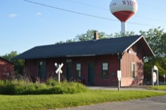 | Chicago, Burlington & Quincy Railroad Depot | building | 1987 | 87000650 |
| Dr. Thomas Hall's Office | building | 2025 | 100012169 |
The NOAA Storm Events Database holds 167 reports for this county, causing no deaths, 1 injury and about $17,143,500 in recorded property damage. Each settlement page carries the reports that name it.
| Kind of event | Reports |
|---|---|
| Thunderstorm Wind | 84 |
| Hail | 44 |
| Flash Flood | 18 |
| Tornado | 16 |
| Flood | 5 |
The most serious of them, by death, then injury, then recorded damage. The accounts are quoted exactly as the forecast office filed them.
| When | Event | Place named | Harm | What the report says |
|---|---|---|---|---|
| June 1998 | Thunderstorm Wind | Countywide | 1 hurt | no account filed |
| June 2013 | Flash Flood | La Fayette | $9,000,000 | Thunderstorms moving over the same areas multiple times resulted in 3.00 to 7.00 inches of rain in nearly all of Stark County during the early morning hours of June 24th. All rural roads were closed and most creeks were flooded out of their banks. State Highway 17, 40, 78, 91 and 93 also had several stretches that were closed. This was the second major flash flood to impact Stark County since mid-April. Most of the flooding subsided by mid-afternoon. |
| April 2013 | Flash Flood | West Jersey | $5,000,000 | Torrential rainfall of 5.00 to 8.00 inches resulted in damage to nearly one thousand houses and businesses in the county. Every creek and stream in the county was flooded. Every road in the county was impassable, and several water rescues were made. |
| July 1972 | Tornado (F1) | not stated | $2,500,000 | no account filed |
| February 2017 | Tornado (EF1) | Castleton | $100,000 | A tornado touched down 0.8 miles southwest of Castleton at 4:12 PM CST. The tornado then tracked northeastward...damaging trees, an outbuilding, and a few homes before crossing into extreme southwestern Bureau County in the National Weather Service Davenport County Warning Area (CWA) at 4:19 PM CST. |
| May 2013 | Thunderstorm Wind | Wyoming | $75,000 | Widespread wind damage occurred from the north side of Wyoming northeastward to Bradford. Numerous trees, tree branches, and power lines were blown down along this path. In addition, minor damage to a few sheds and outbuildings was reported. |
| July 2020 | Thunderstorm Wind | West Jersey | $50,000 | Trees, power lines, and crops were damaged near West Jersey. |
| August 2020 | Thunderstorm Wind | Toulon | $50,000 | Several trees and power lines were blown down. |
| August 2020 | Thunderstorm Wind | Bradford | $50,000 | Several trees and power lines were blown down. |
| August 2020 | Thunderstorm Wind | Wyoming | $40,000 | Several trees and power lines were blown down. |
| August 2020 | Thunderstorm Wind | Elmira | $40,000 | Several trees and power lines were blown down. |
| June 2010 | Thunderstorm Wind | Elmira | $40,000 | Numerous trees were uprooted and blown down. A barn was damaged. |
| August 2007 | Thunderstorm Wind | West Jersey | $35,000 | A swath of thunderstorm wind damage cut across Stark county. The winds blew down numerous trees, power lines, and corn fields. A church in Toulon also had some windows blown out.| |
| May 2013 | Thunderstorm Wind | Toulon | $25,000 | Several trees and power lines were blown down in Toulon. |
| July 1967 | Tornado (F2) | not stated | $25,000 | no account filed |
| September 1959 | Tornado (F2) | not stated | $25,000 | no account filed |
| May 2013 | Thunderstorm Wind | Toulon | $15,000 | A grain bin was blown down in Toulon. |
| June 2010 | Thunderstorm Wind | Toulon | $15,000 | Numerous tree limbs were blown down. |
| August 2007 | Thunderstorm Wind | Toulon | $15,000 | Several trees and numerous corn stalks were blown down. |
| May 2013 | Thunderstorm Wind | Bradford | $12,000 | A shed was blown over in Bradford. |
| June 2017 | Thunderstorm Wind | Wyoming | $10,000 | A tree was blown onto a house. |
| December 2008 | Thunderstorm Wind | Toulon | $10,000 | An outbuilding was damaged between Toulon and Wyoming. |
| June 2014 | Thunderstorm Wind | Bradford | $3,000 | Two trees were blown down onto Route 93. Considerable crop damage was also noted in the area. |
| July 1975 | Tornado (F0) | not stated | $2,500 | no account filed |
| June 2015 | Thunderstorm Wind | West Jersey | $2,000 | A power line was blown down. |
| August 2012 | Thunderstorm Wind | Toulon | $2,000 | A three-foot diameter tree was blown down in Toulon. |
| June 2008 | Thunderstorm Wind | West Jersey | $2,000 | A tree was blown down. |
| March 2026 | Tornado (EF0) | Toulon | - | A tornado touched down just northwest of Toulon at 7:30 PM CDT. The tornado tracked eastward, causing occasional minor tree damage before dissipating east of North Wyoming Road and south of 950 North Road at 7:37 PM CDT. |
| March 2026 | Tornado (EF1) | West Jersey | - | This tornado crossed from far northeastern Knox County into Stark County southwest of Walnut Creek at 7:23 PM CDT. The tornado tracked eastward, damaging a few homes and outbuildings and snapping trees near the intersection of 100 East Road and 450 North Road. It then crossed IL-78 where it caused extensive siding damage, broke windows, and damaged the roof of a home before dissipating north of the intersection of 400 East Road and 400 North Road at 7:29 PM CDT. |
| March 2025 | Thunderstorm Wind | West Jersey | - | Pieces of metal were blown off of farm outbuildings and a small area of drip edge was removed from a home. |
| May 2025 | Tornado (EF0) | Toulon | - | A landspout tornado touched down in a field east of Highway 78 and south of 750 North about 2 miles southwest of Toulon at 5:02 PM CDT. The tornado tracked slowly southwestward causing minor tree damage before dissipating just east of Highway 78 and south of 700 North at 5:06 PM CDT. |
| April 2025 | Thunderstorm Wind | Wyoming | - | The soffit was blown loose from a house. |
| May 2024 | Thunderstorm Wind | Elmira | - | A large tree was blown down across IL-93. |
| May 2024 | Thunderstorm Wind | Toulon | - | Power lines were blown over near the Henry and Stark County border, resulting in power outages. |
| June 2024 | Thunderstorm Wind | Bradford | - | Several trees were blown down on Route 93 in Bradford. |
| June 2024 | Thunderstorm Wind | Toulon | - | A few 6-inch diameter tree limbs were blown down near the Toulon Sheriffs Office. |
| July 2024 | Thunderstorm Wind | Wyoming | - | Trees and power poles blown down. |
| August 2024 | Thunderstorm Wind | Bradford | - | A power pole was snapped and several power lines were blown down. |
| August 2024 | Thunderstorm Wind | West Jersey | - | Several large tree branches were blown down. |
| August 2024 | Tornado (EF1) | West Jersey | - | A tornado touched down along Walnut Creek near the Knox County-Stark County line about 3 miles northwest of West Jersey at 11:06pm CDT. It moved east-northeastward through farm fields before crossing over Walnut Creek again and snapping trees as it progressed across 250 East Road. The tornado then crossed State Route 78 and dissipated in a field at 11:12pm CDT. |
| August 2024 | Thunderstorm Wind | Wyoming | - | A few tree branches were damaged. |
| August 2024 | Thunderstorm Wind | Speer | - | A few silos and grain bins were damaged. |
| July 2024 | Thunderstorm Wind | Osceola | - | Siding was torn off a large shed. |
| June 2022 | Flash Flood | Castleton | - | Water was flowing across the roadway at the intersection of Illinois 17 and Illinois 40 just west of Camp Grove. |
| July 2019 | Thunderstorm Wind | Wyoming | - | A tree was blown down in Wyoming. |
| June 2018 | Thunderstorm Wind | West Jersey | - | A road sign was bent and a corn field was flattened. |
| May 2017 | Thunderstorm Wind | La Fayette | - | A tree was blown down onto Route 78 northeast of La Fayette. |
| June 2017 | Thunderstorm Wind | Toulon | - | Numerous trees were blown down. |
| June 2017 | Thunderstorm Wind | Toulon | - | Numerous trees were blown down. |
| June 2017 | Thunderstorm Wind | Wyoming | - | Numerous trees were blown down. |
| June 2017 | Flash Flood | La Fayette | - | Torrential rain of 2.00 to 3.00 inches in less than two hours produced flash flooding in the southern half of Stark County. Numerous county roads from Toulon to Wyoming and locations to the south were impassable during the evening hours. The flooding dissipated rapidly by late evening. |
| June 2016 | Tornado (EF0) | Bradford | - | A weak tornado briefly touched down in a field 3 miles west-southwest of Bradford at 7:15 PM CDT. No damage was reported. |
| June 2015 | Flash Flood | West Jersey | - | Thunderstorms with rainfall rates of 1.00 to 1.50 per hour persisted for nearly three hours in much of Stark County. Observers reported 3.00 to 4.00 of rain on ground already saturated during the previous week. Many rural roads from West Jersey to Toulon to Wyoming were impassable. |
| July 2014 | Flood | Speer | - | Persistent thunderstorms produced several periods of heavy rainfall. Total accumulations of up to 4.00 of rain were common in most of Stark County. Rainfall rates in Toulon were nearly 4.00 per hour between 2000 and 2015 LST. Many rural roads were closed across Stark County, as were parts of Illinois Routes 17, 40 and 93. Additional rainfall late in the evening of June 30th caused roads to remain closed through the early morning hours of July 1st. |
| June 2014 | Flash Flood | Speer | - | Persistent thunderstorms produced several periods of heavy rainfall. Total accumulations of up to 4.00 of rain were common in most of Stark County. Rainfall rates in Toulon were nearly 4.00 per hour between 2000 and 2015 LST. Many rural roads were closed across Stark County, as were parts of Illinois Routes 17, 40 and 93. |
| June 2014 | Flood | Speer | - | Persistent thunderstorms produced several periods of heavy rainfall. Total accumulations of up to 4.00 of rain were common in most of Stark County. Rainfall rates in Toulon were nearly 4.00 per hour between 2000 and 2015 LST. Many rural roads were closed across Stark County, as were parts of Illinois Routes 17, 40 and 93. Additional rainfall late in the evening of June 30th caused roads to remain closed through the early morning hours of July 1st. |
| May 2013 | Thunderstorm Wind | Bradford | - | A grain bin was blown down. |
| May 2013 | Flood | La Fayette | - | Several rounds of thunderstorms with torrential rainfall produced 3.00 to 6.00 inches of rain in much of Stark County late in the evening of May 26th. This resulted in widespread flash flooding across nearly all of the county. Most roads were impassable and closed through the night. Additional rainfall overnight kept roads closed through the early morning. Flood waters finally subsided by mid-afternoon on the 27th. |
| May 2013 | Flash Flood | La Fayette | - | Several rounds of thunderstorms with torrential rainfall produced 3.00 to 6.00 inches of rain in much of Stark County late in the evening of May 26th. This resulted in widespread flash flooding across nearly all of the county. Most roads were impassable and closed through the night. |
| April 2013 | Flood | West Jersey | - | Torrential rainfall of 5.00 to 8.00 inches resulted in damage to nearly one thousand houses and businesses in the county. Every creek and stream in the county was flooded. Every road in the county was impassable, and several water rescues were made. The flash flooding was so significant that creeks stayed in flood and most roads remained closed until the afternoon of April 22nd. |
The Survey's mineral resources record lists 2 workings inside this county. None of them still produces: all are closed or unrecorded. Each settlement page carries the workings within five miles of it.
| Commodity | Workings |
|---|---|
| Sand and Gravel, Construction | 1 |
| Stone, Crushed/Broken | 1 |
The least common of them first, because a county's hundredth gravel pit says nothing its first ten did not.
| Where | Site | Commodity | Status | Recorded |
|---|---|---|---|---|
| Castleton Pit | Sand and Gravel, Construction | Past Producer | ||
| Stark County Highway Department | Stone, Crushed/Broken | Past Producer |
Documents and Biography Pertaining to the Settlement and Progress of Stark County, Illinois : Containing an Authentic Summary of Records, Documents, Historical Works and Newspapers Relating to Indian History, Original Settlement, Organization and Politics ... devotes a chapter to each township: its boundaries and streams, who settled it and when, the mills, the schools and the churches. All 8 are reproduced here in full. Each row shows the township's own shape and where it lies in the county, drawn from the Census Bureau's boundary. Which settlements belong to which township is computed from that same boundary, not taken from the book.
| Shape and position in the county | Township | Settlements in it | Length | Sections |
|---|---|---|---|---|
| Elmira Township | Elmira, Osceola | 35,788 words | 9 | |
| Essex Township | Duncan, Slackwater | 18,996 words | 1 | |
| Goshen Township | Lafayette | 20,251 words | 1 | |
| Osceola Township | Bradford, Lombardville, Morse | 12,500 words | 5 | |
| Penn Township | Castleton, Waldron | 34,273 words | 12 | |
| Toulon Township | Modena, Toulon, Wyoming | 81,618 words | 6 | |
| Valley Township | Speer, Stark | 13,994 words | 3 | |
| West Jersey Township | West Jersey | 15,449 words | 2 |
3 books written about this county, cut here where the book itself is cut, at its printed chapters: 28 chapters in all. Every chapter is public domain, machine-read from the scan and reproduced complete. A chapter already given under one of the county's towns is not repeated in this list.
| Chapter | Length |
|---|---|
| Chapter 1 | 2,805 words |
| Chapter 2 | 6,422 words |
| Chapter 3 | 9,132 words |
| Chapter 5: The Fauxa of Stark County | 69,864 words in 5 parts |
| Chapter | Length |
|---|---|
| Chapter 23 | 4,069 words |
| Chapter 1: Topography and Natural History | 4,739 words |
| Chapter 2: Indians of Illinois | 5,819 words |
| Chapter with an unread heading (no. 4 of those read) | 14,495 words |
| Chapter 5: Pioneer Associations and Reminiscences | 12,763 words |
| Chapter 6: Organization and Commissioners Court | 16,501 words in 2 parts |
| Schools and Institute | 8,026 words |
| Chapter with an unread heading (no. 8 of those read) | 22,539 words in 2 parts |
| Chapter | Length |
|---|---|
| Chapter 1: Physical Features, Geology, Etc | 4,879 words |
| Chapter 2: Aboriginal Ixiiabitants | 3,457 words |
| Chapter 3: Indian History | 11,198 words |
| Chapter 5: Settleiniext of Stark Couxty | 4,928 words |
| Chapter 6: Stark County Organized | 6,967 words |
| Chapter 8: Cities. Towns and Villages | 9,442 words |
| Chapter 9: Mn.ltary History | 7,588 words |
| Chapter 10: Internal Improvements | 5,776 words |
| Chapter 11: Finance and Industry | 6,434 words |
| Chapter 12: Educational Development | 10,127 words |
| Chapter 13: The Bexcit and Rak | 6,872 words |
| Chapter 14: The Medical Professiox | 3,983 words |
| Chapter 15: Church History | 8,100 words |
| Chapter 16: Societies and Fraternities | 8,023 words |
| Chapter 17: Miscellaneous History | 7,996 words |
| Chapter 18: Statistical Review | 3,705 words |
Named settlements recorded in the Geographic Names Information System, each with the topographic sheets covering it. Villages, hamlets and abandoned places alike. Each is shown with the nearest named watercourse or landform and the survey quadrangle it falls on.
Essex township · 61483 · On Indian Creek · Princeville quadrangle
14 sheets, 1944 to 1990
No longer a settlement
Penn township · 61491 · On Jack Creek · Elmira quadrangle
10 sheets, 1944 to 1985
No longer a settlement
The vanished settlements of Stark County: the places named above that are no longer on the map.