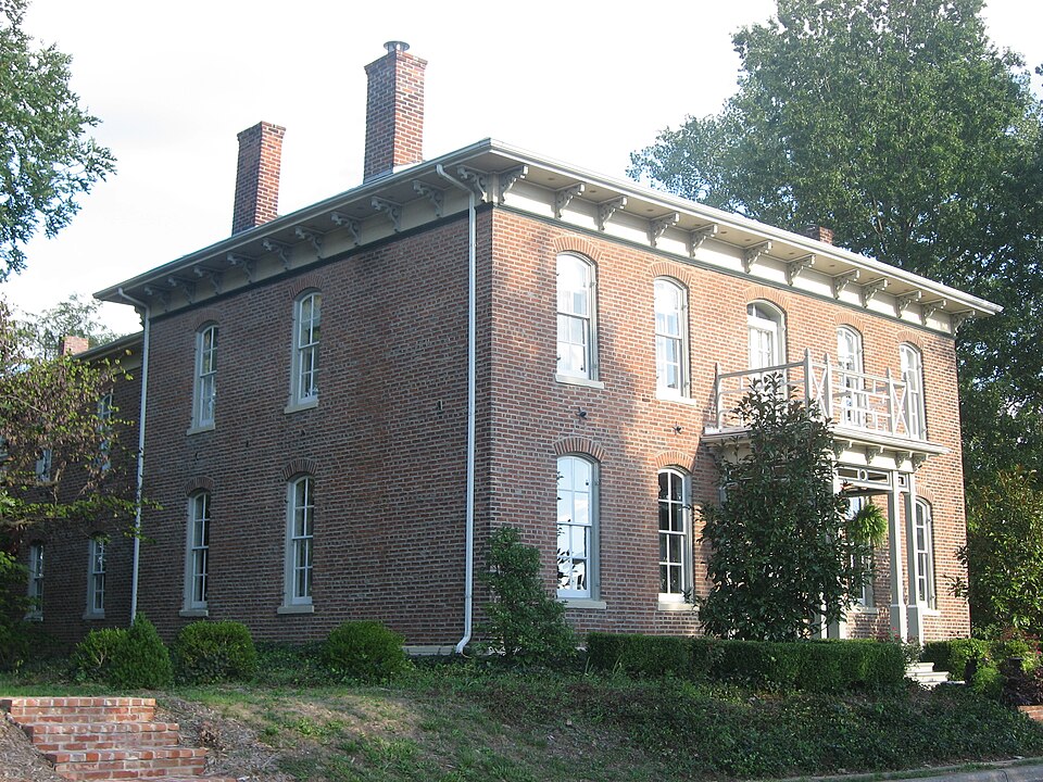
Listed on the National Register of Historic Places in 1990.
From the record
“The Badollet House is one of three properties listed on the National Register of Historic Places in the Marion County, Illinois county seat of Salem. The house was built for businessman Howard Badollet and his wife.”
Wikipedia article Badollet House, CC BY-SA 4.0.
One of 9 National Register listings published here for Marion County · listed in 1990 · category: Building.
National Register reference number.90001839- the number the National Park Service assigned this property when it was listed, and the key its nomination file is catalogued under at the National Archives.
The city of Salem, county seat of Marion county, is within a mile or less from the geographic center of the county, that is, the northeast corner of the city is within less than a mile of the northeast corner of the township, which is at the exact center of the county. The original town was an exact square around which was an alley, twentyfeet wide. The city inside of this alley was divided into four squares by two principal streets at right angles to each other and crossing each other at what is known as the bank corner. Each square was again divided into four equal square blocks by streets fifty feet wide, the two principal streets, Broadway, running north and south and Main street, running east and west, being one hundred feet wide. The blocks in turn were divided into eight lots each fifty-six by one hundred and twelve feet. Block three in square one was reserved as a county square and is still, and forever must be by the terms of the gift, the court-house square. The land within the twenty foot bordering alley, was donated to the county in accordance with the act of the Legislature creating the county, by James Roberts, who was the owner by right of squatter sovereignty and entry in 1819. Although he did not deed the land, but left that to his successors in title, Rufus Ricker and Mark Tully, who confirmed the gift by deed dated June 6, 1826. The Commissioners acting for the county were John S. Davis, Leonard P. Pyles and Benjamin (Blackbear) Vermillion.
The first house in Salem was a log house built by James Roberts ; it stood on the south side of Main street, east of the square, but was not in the original town. It is still standing, having been repaired and weatherboarded and now has the appearance of an old frame house. The second house was built by Mark Tully as a stopping place for the Vincennes stage, which route was in use as early as 1820. This house was built about the time that Ricker and Tully bought Roberts out and stood as the homestead of A. R. Bryan until his death, with, however, many improvements and additions it has sheltered three generations and still stands a commodious and substantial building.
Regional context, not property-specific
evidence. The federal mineral resources record lists
1 working within 5 miles of Badollet House: 1 past producer.
None of them still produces. What was taken out: Stone. Distance is straight-line from the
map coordinates, so a quarry counted here may appear on a neighbouring
settlement's page as well.
Regional context, not property-specific
evidence. The National Weather Service names
Salem, the town this property stands in, in 54 storm reports between 1993 and 2026: 35 thunderstorm wind, 15 hail, 2 tornado, 1 flash flood.
No death or injury is recorded in these reports. Each account below is quoted exactly as the forecast office
filed it, from the NOAA Storm Events Database, and each date
opens the federal record of that event.
The Illinois State Police reported 12-inch diameter tree limbs broken off in Salem. Park officials from Stephen A. Forbes State Park reported hail larger than baseballs fell several minutes later between Omega and Iuka. A total of 10 cars had their windshields and windows either damaged or smashed. Several nearby church windows were also broken and four homes had roof damage. Crops were leveled in a 3 mile long and 0.5 mile wide path.
Thunderstorm winds downed numerous tree limbs and power lines in Salem. At least one large tree was uprooted. Falling branches or a downed tree damaged at least one home. A farm outbuilding was destroyed.
There were numerous public reports of extensive tree damage around Salem. A light pole was also downed in town. The Salem AWOS measured a 64 mph gust as the storm moved through.
The county sheriff's office reported trees and power lines down southwest of Salem. The county ESDA director reported trees and power lines down in Centralia along with numerous mobile homes and a few garages damaged in Central City.
The Illinois State Police reported 12-inch diameter tree limbs broken off in Salem. Park officials from Stephen A. Forbes State Park reported hail larger than baseballs fell several minutes later between Omega and Iuka. A total of 10 cars had their windshields and windows either damaged or smashed. Several nearby church windows were also broken and four homes had roof damage. Crops were leveled in a 3 mile long and 0.5 mile wide path.
Numerous trees were snapped off and roofs damaged south of Odin while a mobile home south of Salem was completely destroyed. Several stores in Centralia also had broken windows and trees were blown down damaging parked cars.
Thunderstorm wind blew down several large trees and numerous tree limbs around town. Several large branches landed on homes causing minor to moderate roof damage.
Thunderstorm winds blew down a large tree, several tree limbs and power lines in town. The tree knocked down a power pole as it fell causing a power outage.
Rainfall of 2 to 4 inches from May 7 into May 8 caused flooding of small streams and low lying areas. Several roads in Salem, including Highway 50 were covered with up to a foot of water. Flooding was also reported along Route 37 just south of Salem. In Centralia, numerous city streets were covered with water making travel difficult.
A tornado first formed about 2:35 PM CST near Hays and Sullivan Road about 10 miles northeast of Salem. The tornado moved northeast and crossed Stephen A. Forbes State Park causing tree damage along the way. Most of the damage was F0 in nature except for one area in the western part of the park where F1 tree damage was noted. After moving across the park, the tornado destroyed a 32 foot travel trailer and a machine shed. The damage in this area was rated F1 and was about 50 yards wide. The tornado continued east and crossed Butts Road just east of Meacham Road. At least 3 farms in this area suffered damage. One home lost its entire roof, several machine sheds and outbuildings were destroyed, and large trees were downed. The damage was rated F1 and was about 100 yards wide. The tornado continued northeast and dissipated just south of Kinlou Road. Total path length was 5 miles.
No historic map-sheet match is published
for this property yet. That does not mean no map exists. This record needs
a coordinate-quality review before it can be joined to a sheet boundary.
Browse the county's mapped places while that work is
pending.
Listed places nearby
3 within 8 miles
Other National Register properties close
enough to walk or drive between, ordered by distance from this one. Both
positions come from the same geocoding pass that matched these properties
to their map sheets.
Listing record. National Park Service National Register of Historic Places, listed-properties dataset, current to 2026-05-22.
Map join. Address geocoded through the United States Census geocoder, then tested against the published boundary of every sheet in the USGS Historical Topographic Map Collection.
How this page is made. Listing fields come from federal records; map-sheet coverage is a labelled coordinate-to-boundary calculation, not a source-field claim.
Mines and quarries. USGS Mineral Resources Data System (MRDS) https://mrdata.usgs.gov/mrds/ A work of the United States government, no copyright under 17 U.S.C. 105.
Storms. NOAA National Centers for Environmental Information, Storm Events Database https://www.ncei.noaa.gov/stormevents/ A work of the United States government, no copyright under 17 U.S.C. 105. Narratives are quoted verbatim from the National Weather Service report and are not edited or summarised.
 Block