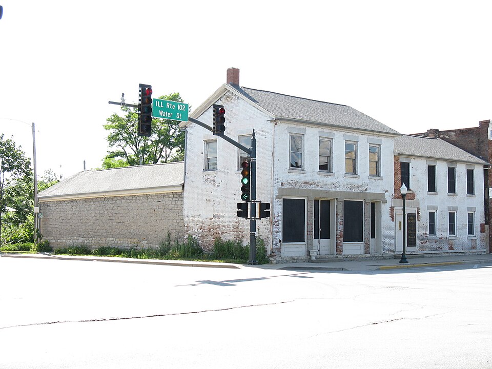
National Register reference number.94000021- the number the National Park Service assigned this property when it was listed, and the key its nomination file is catalogued under at the National Archives.
The ground it stands on
4,757 words
The chapter on Wilmington Township in History of Will County Illinois, published 1878 names Wilmington. This is what it says, exactly as the scans read.
The village of Wilmington was laid out in 1836, and as this and its immediate vicinity was the objective point toward which the early settlers naturally cast their eyes, the early history is necessarily embraced in that of the township. However, in 1854, having attained a population required by law, it was deemed best by most of the leading citizens to organize the village as a separate corporation. It was argued that this would give the village authority to build sidewalks, abate nuisances, control the liquor traffic, and, perhaps, obtain some revenue from the trade in the way of license, and numerous other advantages not enjoyed while merely constituting a portion of the township. Therefore, a notice, signed by '"' Many Citizens,' requesting the residents and freeholders to meet at the schoolhouse on Saturday, the 24th day of June, to take into consideration the incorporation of the town, was posted in various public places by S. W. Munn ten days before the date specified in the notice. At the meeting, Peter Stewart was called to the chair, and James F. Alden was selected as Clerk. The advantages of incorporation were then argued pro and con. (mostly pro), after which a vote was taken, resulting in favor of organization 12 to 1. A day was then appointed for the election of a town board, and on the 3d day of July the election took place. Of the election, Peter Stewart and James F. Allen occupied the position designated at the primary meeting. Sixty-three votes were cast, and D. W. Smead, J. D. Henderson, Samuel C. Thompson, J. A. Seebor and James F. Alden were elected Trustees ; James LL. Young was chosen Clerk; Anthony Riker, Street Commissioner, and Fred. Walrath, Constable. Thus was the incorporation of the village fully accomplished, and under this organization it continued eleven years. D. W. Smead was chosen first President. His successors were as follows: 1855, H. Warner; 1857, Anson Packard; 1858, Israel Massey ; 1859, S. W. Munn; 1860, William Harbottle; 1861, John D. White; 1862, John S. Jessup; 1864 E. H. Jessup.
About the date last named, the question of changing the charter of the town, so as to give the incorporation some additional powers and a more genteel title, began to be agitated, and resulted in obtaining from the Legislature a charter, February 15, 1865, "constituting the inhabitants of said town a body corporate, by the name and style of city of Wilmington." Under this charter, the first election was held on the third Tuesday of March of the year named.
Regional context, not property-specific
evidence. The
federal wildfire occurrence database
lists 17 fires within 5 miles of Eagle Hotel
between 2002 and 2018, burning about 349 acres in total. 1 started naturally. 1 was recorded as arson.
Distance is straight-line from the map coordinates, so a fire counted
here may appear on a neighbouring settlement's page as well.
Reported cause
Fires
Equipment and vehicle use
7
Smoking
4
Debris and open burning
2
Arson/incendiarism
1
Missing data/not specified/undetermined
1
Natural
1
Railroad operations and maintenance
1
The most recent of
them, most recent first, with the day each was reported and the service
that recorded it.
Regional context, not property-specific
evidence. The federal mineral resources record lists
3 workings within 5 miles of Eagle Hotel: 2 past producers, 1 occurrence.
None of them still produces. What was taken out: Stone, Crushed/Broken, Sand and Gravel, Construction. Distance is straight-line from the
map coordinates, so a quarry counted here may appear on a neighbouring
settlement's page as well.
Regional context, not property-specific
evidence. The National Weather Service names
Wilmington, the town this property stands in, in 35 storm reports between 1994 and 2025: 15 hail, 13 thunderstorm wind, 4 flash flood, 1 wildfire.
No death or injury is recorded in these reports. Each account below is quoted exactly as the forecast office
filed it, from the NOAA Storm Events Database, and each date
opens the federal record of that event.
A car drove into flood waters on Ballou Road near Forked Creek and was submerged to the roof of the car. One of the three occupants swam to dry ground to get help. The other two occupants were rescued several hours later.
Numerous reports of tree damage were received in and near Wilmington. Fascia damage occurred to a house. A photo shared on social media showed a large section of roofing material that was blown into the street in the business district.
An ice jam formed on the Kankakee River near the Interstate 55 bridge. This ice jam caused localized flash flooding near the river, downstream of Wilmington.
An ice jam formed on the Kankakee River near the Interstate 55 bridge. This ice jam caused localized flash flooding affecting yards and roads in the Phelan Acres subdivision.
Several roads were flooded and closed including Route 53 at Kankakee Street and Main Street, as well as Main Street and River Street. An observer in nearby Manhattan measured 3.25 inches of rain.
No historic map-sheet match is published
for this property yet. That does not mean no map exists. This record needs
a coordinate-quality review before it can be joined to a sheet boundary.
Browse the county's mapped places while that work is
pending.
Listed places nearby
2 within 8 miles
Other National Register properties close
enough to walk or drive between, ordered by distance from this one. Both
positions come from the same geocoding pass that matched these properties
to their map sheets.
Listing record. National Park Service National Register of Historic Places, listed-properties dataset, current to 2026-05-22.
Map join. Address geocoded through the United States Census geocoder, then tested against the published boundary of every sheet in the USGS Historical Topographic Map Collection.
How this page is made. Listing fields come from federal records; map-sheet coverage is a labelled coordinate-to-boundary calculation, not a source-field claim.
Wildfire. Short, Karen C. 2022. Spatial wildfire occurrence data for the United States, 1992-2020 [FPA_FOD_20221014]. 6th Edition. Fort Collins, CO: Forest Service Research Data Archive. https://doi.org/10.2737/RDS-2013-0009.6 Collected with United States Government funding and usable without additional permissions or fees.
Mines and quarries. USGS Mineral Resources Data System (MRDS) https://mrdata.usgs.gov/mrds/ A work of the United States government, no copyright under 17 U.S.C. 105.
Storms. NOAA National Centers for Environmental Information, Storm Events Database https://www.ncei.noaa.gov/stormevents/ A work of the United States government, no copyright under 17 U.S.C. 105. Narratives are quoted verbatim from the National Weather Service report and are not edited or summarised.
 Block