Listed on the National Register of Historic Places in 1994.
From the record
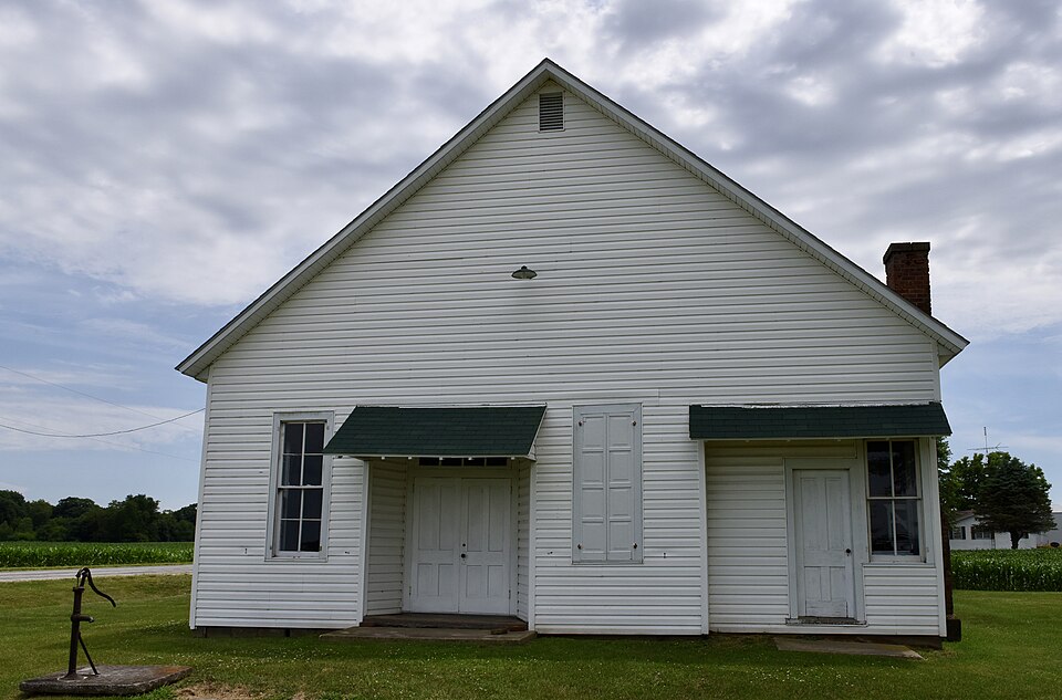
“The South Fulton Churchhouse is a historic church located on Baden Road roughly two miles south of Astoria, Fulton County, Illinois. The church was built in 1879 for the western body of Astoria's German Brethren congregation.”
Wikipedia article South Fulton Churchhouse, CC BY-SA 4.0.
One of 38 National Register listings published here for Fulton County · listed in 1994 · category: Building.
National Register reference number.94001264- the number the National Park Service assigned this property when it was listed, and the key its nomination file is catalogued under at the National Archives.
The ground it stands on
25,340 words
The chapter on Astoria Township in History of Fulton County, Illinois;, published 1879 names Astoria. This is what it says, exactly as the scans read.
Astoria may truly be said to be one of the most flourishing towns in Central Illinois, and only few in the State of the same number of inhabitants excel it in the display of enterprise. In detailing the history of Astoria we shall begin at a very early date in pioneer history.
Louis, in 1837, moved a quarter of a mile westward, where they laid out the present town of Astoria. Mr. Gilbert moved his storebuilding; and located it upon the site now occupied by the store of Lovell & Smith, grocers. In a short time the new village boasted of a postmaster. This gentleman was a Dr. James Owen, who came from Ohio. The postoffico was kept in a small frame building that stood upon the west side of the square. This town was more fortunate than most frontier towns, i'or it was on the line of the daily four-horse stage-coach from Peoria to Quincy, from 1836 till 1843, and was the point at which dinner was taken.
Regional context, not property-specific
evidence. The federal mineral resources record lists
1 working within 5 miles of South Fulton Churchhouse: 1 past producer.
None of them still produces. What was taken out: Sand and Gravel, Construction. Distance is straight-line from the
map coordinates, so a quarry counted here may appear on a neighbouring
settlement's page as well.
Regional context, not property-specific
evidence. The National Weather Service names
Astoria, the town this property stands in, in 31 storm reports between 1996 and 2025: 15 thunderstorm wind, 11 hail, 4 flash flood, 1 tornado.
No death or injury is recorded in these reports. Each account below is quoted exactly as the forecast office
filed it, from the NOAA Storm Events Database, and each date
opens the federal record of that event.
Slow moving thunderstorms produced copious amounts of rainfall in the southern third of Fulton County late in the evening of July 28th. Rainfall amounts of 4.00 to 5.00 were measured in 90 minutes which produced more than two feet of water on many rural roads. A few vehicles were submerged in flooded viaducts, and several water rescues of stranded motorists were made. There were no injuries reported.
Thunderstorms produced 3.00 to 5.00 of rain on extremely saturated ground in southern Fulton County during the evening of June 15th. The biggest impact was the flooding of rural roads from the town of Vermont south to U.S. Highway 24. Parts of U.S. Highway 24 were also flooded from Astoria to the Schuyler County line.
Slow moving thunderstorms with very heavy rainfall produced an average of 3.00 of rain in less than two hours in extreme southern Fulton County. Rural roads within one to two miles of the Schuyler County line were impassable. U.S. Highway 24 from two miles west-southwest of Astoria to the Schuyler County line was closed. The flooding subsided within about three hours by mid-afternoon.
Thunderstorms produced heavy rainfall, with rates of 1.50 inches per hour for at least two hours during the late evening of August 10th in southwest Fulton County. U.S. Route 136 from Ipava to the county line was covered with two to three feet of water in spots and was closed for a few hours.
A tornado touched down half a mile south of town then traveled east northeast. It destroyed several sheds and damaged a business. Numerous trees, tree limbs, power lines and power poles were blown down. No injuries were reported.
Thunderstorm winds blew down numerous trees, including some that were over two feet in diameter at the Anderson Lake State Fish and Wildlife Area. Some buildings sustained minor damage due to the fallen trees.
Numerous trees and tree limbs were blown down in the Astoria area. Some of the trees fell over onto US 24 two miles east northeast of Astoria. As the storms approached the Sepo area, several large trees were blown down across US Route 136 three miles south of Sepo. Several more trees were blown down onto Route 78 one mile south of US Route 24. No injuries were reported.
A line of severe thunderstorms moved through Fulton county. In Astoria, a couple of mobile homes were damaged, several business signs, trees, tree limbs, and power lines were blown down. At the same time in Avon, numerous power lines and tree limbs were blown down and the township garage sustained some damage. Numerous trees, tree limbs, and power lines were blown down throughout the county. No injuries were reported and no damage estimate was available.
No historic map-sheet match is published
for this property yet. That does not mean no map exists. This record needs
a coordinate-quality review before it can be joined to a sheet boundary.
Browse the county's mapped places while that work is
pending.
Listed places nearby
6 within 8 miles
Other National Register properties close
enough to walk or drive between, ordered by distance from this one. Both
positions come from the same geocoding pass that matched these properties
to their map sheets.
Listing record. National Park Service National Register of Historic Places, listed-properties dataset, current to 2026-05-22.
Map join. Address geocoded through the United States Census geocoder, then tested against the published boundary of every sheet in the USGS Historical Topographic Map Collection.
How this page is made. Listing fields come from federal records; map-sheet coverage is a labelled coordinate-to-boundary calculation, not a source-field claim.
Mines and quarries. USGS Mineral Resources Data System (MRDS) https://mrdata.usgs.gov/mrds/ A work of the United States government, no copyright under 17 U.S.C. 105.
Storms. NOAA National Centers for Environmental Information, Storm Events Database https://www.ncei.noaa.gov/stormevents/ A work of the United States government, no copyright under 17 U.S.C. 105. Narratives are quoted verbatim from the National Weather Service report and are not edited or summarised.
 Block